Environment News: March 2026 - Issue 652

Week Three March 2026: Issue 652 (published Sunday March 15)

Great News for Australian Wildlife: APVMA certifies that second generation anticoagulant rodenticides should be restricted chemical products

On Tuesday March 10 2026 the Australian Pesticides and Veterinary Medicines Authority (APVMA) certified that it is in the public interest for chemical products containing any second-generation anticoagulant rodenticides (SGARS) to be declared restricted chemical products (RCPs).

SGARs have a devastating effect on native reptiles and birds, including owls, that receive lethal or crippling doses when they consume already-poisoned rodents. Wildlife carers have been calling for years for the ban due to the poison's risk on native animals.

Pittwater kookaburra - one of the local bird species residents have seen impacted by rat poisons - whole families are killed when parent birds feed poisoned rats to offspring

Declaring SGARs as RCPs will enable tighter controls on their purchase and use, including restricting access to individuals who meet specific training and licensing requirements.

If the certification is accepted by the Australian Department of Agriculture, Fisheries and Forestry (DAFF), the APVMA, together with state and territory control-of-use authorities, will consider how training and licensing requirements could be implemented.

The certification follows the APVMA’s proposed decision of 16 December 2025 to suspend SGAR products, which commenced a targeted 6-week consultation with product holders and state and territory authorities.

During this consultation, state and territory chemical coordinators advised that declaring SGARs as RCPs would provide the most robust legal framework for ensuring access can be restricted to licensed and authorised users in a nationally consistent manner.

Suspension decision

In parallel with the RCP certification, the APVMA has also announced that the registration of all products containing SGARs will be suspended for one year from 24 March 2026.

The suspension will allow stricter controls on the use of SGARs to be implemented quickly, while broader measures to support the potential RCP declaration are progressed.

Between 16 December 2025 and 27 January 2026, the APVMA consulted with state and territory authorities and holders of affected products on the proposed suspension. Fourteen submissions were received.

After carefully reviewing the submissions, the APVMA’s risk conclusions remain unchanged. The APVMA had determined that the current use of SGAR products presents unacceptable risks to non-target animals*, including native wildlife.

During the suspension period, SGAR products may only be supplied or used in accordance with the instructions published in the APVMA Gazette No 5, Tuesday 10 March 2026, or as specified in the notice issued to each product holder.

These instructions are enforceable under state and territory legislation and apply nationally.

The suspension introduces strong risk mitigation measures to protect Australia’s native fauna, pets and livestock while the APVMA finalises its full regulatory consideration of first- and second-generation anticoagulant rodenticides.

Reconsideration 

Public consultation on the proposed reconsideration decisions on all anticoagulant rodenticide products remains open until 16 March 2026, details below.

The proposed decisions include a range of restrictions on how and where all anticoagulant rodenticide products, including first-generation products, may be used. These restrictions are designed to reduce risks to people and non-target animals. The APVMA has also proposed cancelling specific products that pose an unacceptable risk.

Further information is available on their website, including details of the consultation period and guidance on how to make a submission.

*Referred to throughout the scientific, technical and decision reports, non-target animals include native wildlife such as birds and marsupials, pets and livestock.

** SGARs – These are products containing the active ingredients: brodifacoum, bromadiolone, difenacoum, difethialone and floucoumafen.

Protect Aussie birds from lethal SGAR rat poisons: add your voice

Australia’s native birds, wildlife, and even family pets are being poisoned by Second-generation Anticoagulant Rodenticides (SGARs), a dangerous class of chemicals which are still readily available in supermarkets and online. BirdLife Australia is calling for all SGARs to be removed from public sale and restricted to licensed professionals.

BirdLife Australia says:

''Last month, Australia’s national regulator — the Australian Pesticides and Veterinary Medicines Authority (APVMA) — failed to act on mounting evidence of the serious risks posed by SGAR rat poisons. This puts our birds of prey, native wildlife, and household pets at continued risk.

The APVMA has instead proposed a set of inadequate, half-measures. The proposed changes will not deliver any meaningful reduction in wildlife poisoning.''

Submissions are now open! Tell the regulator to remove SGARs from supermarket and retailer shelves, ensuring the general public cannot access these highly toxic products that are killing wildlife.

Add your Voice here - closes March 16, 2026

New ban on dangerous rodent poisons is lifeline for our native animals

A Masked owl killed by rodenticide. Karen Majer
Robert DavisEdith Cowan University

We’ve just had an epic win for our native animals, such as owls, goannas and eagles. And after years contributing to the scientific evidence on the wildlife impact of rodent poisons, it’s a day scientists like myself feared would never come.

This week, the federal pesticides regulator finally announced a ban on the sale of a type of rodent poisons called second-generation anticoagulant rodenticides (SGARs).

This means that some commonly used rat baits will be taken off the shelf at supermarkets and hardware shops. These baits can have a devastating effect on native animals, which receive lethal or crippling doses when they eat poisoned rats and mice.

Let’s look at what these rodent poisons (or rodenticides) are, why they are lethal for wildlife, and why they needed to banned.

Two men look at a row of dead owls on a bench.
Dr Boyd Wykes (left) and Associate Professor Rob David look at dead owls poisoned by rodenticides. Karen MajerCC BY-ND

What’s wrong with “second generation” rodent poisons?

Rat and mouse baits are an essential part of everyday life – people use them without thinking. Most baits are anticoagulants, which stop the blood coagulating or clotting and cause animals to bleed to death.

The first over-the-counter baits (developed in the 1940s) used chemicals such as warfarin and coumatetralyl, and are the first-generation anticoagulant rodenticides (FGARs). Notably, these chemicals break down relatively quickly, both in the environment and the livers of animals who consume them. For example, warfarin only lasts 35 days.

But as rats and mice developed resistance to these baits, second-generation anticoagulant rodenticide (SGARs) were developed. The active chemicals in these baits persist much longer in the tissues of the animals who eat them. They can last up to 217 days (brodifacoum) and 248 days (bromodiolone).

This means poisoned rodents move around with these persistent chemicals in their body until they die. And when predators such as owls or goannas eat them, these chemicals accumulate in their livers. The more rodents an animal eats, the higher the concentrations of chemicals that builds up. Eventually, this makes them sick, and often leads to death from poisoning.

When our lab starting working on this issue a decade ago, the problem was well known overseas but poorly studied in Australia. In our first review of the topic, we identified the need for stronger regulation of SGARs in Australia, noting many instances of wildlife exposure here. Australia was lagging behind other countries in awareness and regulation.

My then-PhD student Mike Lohr, now an independent researcher, undertook the first dedicated study on wildlife exposure in Australia. He found 73% of 73 Australian boobook owls were poisoned. We were alarmed enough look more broadly. Sadly, our work identified high rates of exposure and lethal poisoning in native reptiles and threatened carnivores. And colleagues have documented poisoning of many of our night birdspossumseagles and even frogs.

Endless review had disappointing outcome

The science is unequivocal but Australia fell behind many countries in refusing to withdraw these products from sale to domestic consumers. A regulatory review due in 2015 was delayed multiple times. In the meantime, faced with a lack of action from the regulator, there has been a people-led “owl-friendly” movement, in which councils took action to educate citizens and retailers on the issue and encourage them to stop using SGARs.

In July 2024, I was part of a scientific delegation to Parliament House in Canberra to meet with politicians and the federal pesticides regulator, the Australian Pesticides and Veterinary Medicines Authority, to present our scientific evidence. The review was delayed another year, and finally released just before the end of 2025.

Unfortunately, it fell short of what many of us had expected. It relied on simple label changes and the use of tamper-proof bait boxes to present wildlife from being poisoned. It even suggested removing most of the less-harmful rodent poisons from sale because they lacked required bitter-tasting ingredients to be compliant. But it proposed no regulation of the dangerous second-generation poisons.

Our own research (currently under peer review), proves native wildlife is at risk of eating bait directly from tamper-proof bait boxes. We recorded up to 21 species of native wildlife interacting with bait boxes (investigating, feeding in close proximity or even with their heads in bait boxes). Furthermore, poisoned mice and rats are still being eaten by native predators as long as SGARs are being used.

Finally, Australia goes from laggard to leader

Unexpectedly, on March 10 2026, the pesticides authority announced that after consulting with states and retailers, SGARs sales would be suspended for a year, with regulatory controls put in place to prevent sale to consumers. SGARs will still be available to licensed and trained pest controllers.

This news is very welcome, however after the year-long suspension we need SGARs to be defined as a “restricted chemical product” (RCP). This means they can be removed from sale to consumers permanently, and only be accessible to commercial providers.

The removal of these toxic rodent baits from public sale will save countless native animals from suffering, and improve the outlook for many threatened species. First-generation rodent poisons and non-coagulant baits that are better for wildlife will remain available for home users.

And there are many alternatives to try first before reaching for those baits. These include cage traps, snap traps, electric traps, good hygiene practices and rodent-proofing. The owls and goannas will thank you.The Conversation

Robert Davis, Associate Professor in Wildlife Conservation, Edith Cowan University

This article is republished from The Conversation under a Creative Commons license. Read the original article.


Council - local politicians back Ingleside fauna corridor land campaign: Update

Local MPs have joined councillors in calling for land next to the wildlife crossings at Ingleside to be protected from residential development.

The land adjacent to the fauna bridge across Mona Vale Rd East enables wildlife to cross from the bushland of Ingleside Chase Reserve, via the overpass or fauna underpass, to Ku-ring-gai Chase National Park.

Fauna overpass on Mona Vale Road East looking towards Ingleside Chase Reserve   Photo D Palmer

However, under the draft Northern Beaches Council Local Environment Plan, the land, owned by the NSW Planning Department, will be zoned C3 which will allow houses to be built on it.

Council staff say the state Planning Department would have to grant permission for the land to be “downzoned” to C2 - which would prevent that development. 

At its meeting on February 17, Cr Miranda Korzy proposed a motion asking Council to take action to find ways to protect the bushland corridor, which was passed by councillors.

Council has now sent correspondence to a number of state government departments, including Planning, seeking their co-operation.

Pittwater Natural Heritage Association has also gained the support of Pittwater state MP Jacqui Scruby and Wakehurst state MP Michael Regan.

Ms Scruby said she supported Pittwater Natural Heritage Association’s call for the land next to the fauna crossings on Mona Vale Road East to be protected.

“If this doesn’t happen, the significant investment already made in building the wildlife crossings will effectively have been wasted,” she said.

Pittwater Natural Heritage Association secretary David Palmer welcomed the action by Northern Beaches Council.

“Thanks to Cr Korzy and all Northern Beaches Councillors for resolving to take action, and MPs Jacqui Scruby and Michael Regan for supporting us,” Mr Palmer said.

“This is a significant step on the way to preventing native animals which use the fauna bridge and underpass to cross Mona Vale Road East from being blocked by houses and backyard fences.”

Ms Korzy said she was grateful for the strong support on the issue.

“The unanimous vote by councillors and now the support of our local MPs indicates the high priority that residents place on wildlife protection,” Ms Korzy said.

See February 2026 report: The fauna bridge on Mona Vale Road East – will it be a bridge to nowhere?

Fauna bridge on Mona Vale Road East. Ingleside Chase Reserve is on left. Photo David Palmer

The land is a critical element in the pathway for native fauna populations in Ingleside Chase reserve to cross Mona Vale Road east and disperse through bushland in Ingleside to Ku-ring-gai Chase National Park. 

The land was set aside in the 2016 Ingleside Precinct Structure Plan, and marked as a fauna corridor. This was part of an agreement between Transport for NSW, (then RMS) and the NSW Department of Planning to create a corridor, fauna underpass and fauna bridge over Mona Vale Road East which would link Ingleside Chase Reserve with Ku-ring-gai Chase National Park. 

However, in the new Local Environment Plan for the Northern Beaches this land has been zoned C3 which allows housing. If houses are built on it, then native animals which cross the fauna bridge or use the underpass will have nowhere to go.

Pittwater Natural Heritage Association secretary David Palmer is calling for action by the Department of Planning to remedy the situation. 

PNHA member Jacqui Marlow has been involved in rescuing native fauna in the area for many years. She says that protection of the fauna corridor land is critical for the long-term survival of native animals. 

She explained that “If native animals are not able to move between habitats, they will face gradual population decline leading to local extinction. We have many threatened mammals and birds in Ingleside Chase reserve including Eastern Pygmy Possums, which are listed as vulnerable in NSW. They depend on being able to move safely through the landscape to find food, shelter and mates.”

Eastern Pygmy possum near the fauna bridge on Mona Vale Road East. Photo David Palmer

The map below shows recorded sightings of Eastern Pygmy Possums on both sides of the fauna bridge and underpass on Mona Vale Road East.

Eastern Pygmy Possum sightings near the fauna bridge and underpass on Mona Vale Rd east. Image: Atlas of living Australia 2025

Native animals have been photographed using the fauna bridge, showing that it is working, and as the vegetation on and around it grows thicker, more animals will use it. But if, after crossing the fauna bridge, animals encounter back yards, fences and domestic pets, then it will prove to be a bridge to nowhere.

Previous to 2026 reports:

Mona Vale Road (East) Upgrade: Fauna Bridge Supports Installed - August 2023

Mona Vale Road Upgrade Update: Fauna fencing to be installed during construction  + June night works - June 2019

Sydney's first Fauna Overpass to be installed on Mona Vale Road - March 2018

Reducing Roadkill On Mona Vale Road - September 2017

Bill to Facilitate Mona Vale Road Upgrades Passes: Vital Fauna Bridge Discussed - June 2016

Connecting Wildlife Habitats to Prevent Road Kill - August 2014

Once Was Barrenjoey - August 2014

Background

In 2014 Pittwater Natural Heritage Association, Wildlife Roadkill Prevention Association (Northern Beaches) and Katandra Bushland Sanctuary Trust began campaigning to connect threatened bushland reserves in the Pittwater area in a bid to help stop the decline of our native fauna.

According to information gathered by local wildlife volunteers in 2015 – 2016 over 53 wallabies died on Mona Vale Road between Terrey Hills and Mona Vale. Although Wallabies were counted as an indicator species, many other native species have also died on Mona Vale Road, including possums and echidnas. These distressing statistics sparked members of these community groups into calling for action to reduce roadkill on this road.

In May 2016, when the National Parks and Wildlife Amendment (Adjustment of Areas) Bill 2016 was passed on Tuesday, May 31st, 2016 part of the speeches during the Reading of this Bill focused on the necessity to make provision for a fauna bridge or bridges.

In September 2017, after years of lobbying NSW Roads and Maritime Services to get more fauna underpasses and overpasses included in the upgrade of Mona Vale Road East, Jacqui Marlow, Marita Macrae and David Palmer of Pittwater Natural Heritage Association were told at a meeting with NSW Roads and Maritime Services that the fauna crossings they had been campaigning for were now included in the final plans for the eastern section of the road upgrade.

This completed the suite of fauna road crossings that have been planned for the upgraded Mona Vale Road between Mona Vale and Terrey Hills. This included both sides of the road being fenced along its entire length to guide native animals to the crossing sites.

In March 2018 the officially announcement confirming the MVR West Upgrade fauna bridge was made.

There were actually 4 fauna passes - 2 for East and 2 for West - 2 x bridges and 2 x underpass, as stated in 2018. This is the result of work by PNHA and WRPA in concert with the great staff at Transport for NSW/RMS over a few years - they commenced talks about this soon after the project was announced - along with support and backing from former Pittwater MP Rob Stokes.


Land and Environment Court Proponents Appeal: Moran Seniors Development at Ocean Street, Narrabeen - Update 

A Land Environment Court Appeal by Moran was the subject of a directions hearing on Thursday 12 February 2026: 'Indigo by Moran Pty Ltd v Minister for Planning and Public Spaces'.

The developer has applied for "deemed refusal" even though it had not provided responses to the objections by the community.

The matter has been set for a Conciliation Conference at the Court on 21 July, and a further Directions Hearing on 28 July. 

An interim Directions Hearing was also set for March 12 and again on April 2, as the solicitor from the NSW Department of Planning and Environment has formally raised the contention the appeal is premature because of an outstanding request for response to public submissions. 

It is understood the developer disputes this contention. 

The additional listings allows the parties to continue correspondence on this aspect of the dispute.

The exhibition of the development application and environmental impact statement (EIS) for Indigo By Moran at 156 Ocean Street Narrabeen (SSD-76220734) ended on 6 November 2025.

As of November 10 2025 the NSW Dept. of Planning required a written response to issues raised in the submissions, as required under section 59(2) of the Environmental Planning and Assessment Regulation 2021. The written response must be in the form of a submissions report that has been prepared having regard to the State Significant Development Guidelines including Appendix C - Preparing a Submissions Report.

The  submissions report must also incorporate responses to agencies’ advice.

The submissions report was required within two months via the NSW Planning Portal.

All 746 submissions have been placed on the NSW Planning Portal at: www.planningportal.nsw.gov.au/major-projects/projects/indigo-moran-156-ocean-street-narrabeen

Indigo by Moran is seeking a proposed maximum height of the new buildings on 156 Ocean Street of  21.1 metres. The standard height granted under the State Environment Planning Policy is 8.5 metres.

This means the project is seeking a 71.5 per cent increase on the local building height limit.

Under the proposed plans for Indigo by Moran, the DA proposes an existing seniors housing development ( W. G. Taylor Retirement Home and Village) and three adjacent residential dwellings be demolished and a “5 to 6 storey” senior housing development, set to cost north of $140 million, with three levels of basement for 192 car spaces, including seven visitor spaces.

There will be 149 independent living units with access to a fitness centre, pool, sauna, cinema, wine room, library, lounge and roof top terrace with a pavilion.

Ten beds have been earmarked for a “residential care facility”.

The project seeks to remove 69 trees (24 of which are significant) and will retain 13 trees (7 significant trees and 6 non-significant).  The trees to be retained are neighbouring trees and those on the periphery of the site including the well-established Norfolk Island Pine trees located along the Ocean Street and Octavia Street frontage. Any understory of these trees will likely be removed and re-landscaped, the EIS states.

The proponents documents showed they were applying for a BDAR Waiver Request, which was granted by a Director Greater Sydney, of the Department of Climate Change, Energy, the Environment and Water, under section 7.9(2) of the Biodiversity Conservation Act 2016, in July 2025, months before any input from the community was invited

A BDAR Waiver Request is an application to the NSW Department of Planning and Environment to waive the requirement for a Biodiversity Development Assessment Report (BDAR) for a project, which can only be applied for by a proponent of a State Significant Development (SSD) or State Significant Infrastructure (SSI) project. So any impact on wildlife that feeds on the trees and landscape elements to be removed, or lives in these trees, is considered to be not 'significant'.

A comment during the November submissions period from a previous owner of 8 Octavia Street Narrabeen said they wanted to make it known there are two significant black bean trees side-by-side on the property which are of considerable value to the ecology and history of this site. 

''It would be of great benefit to the area if they could be retained.'' the prior owner commented

This pair of culturally significant black bean trees are to be destroyed, as listed (35 and 36) in the Arboricultural Impact Appraisal and Method Statement lodged with the NSW Planning Department, as part of the proposal. 

Another contractor is undertaking the Aboriginal community consultation and preparing an Aboriginal cultural heritage assessment report (ACHAR) to meet the Secretary's environmental assessment requirements (SEARs) for the proponent. 

A report lodged so far found that is 'no built environmental heritage' the proposal may impact on.  A Redacted ACHAR report for 156-164 Ocean St Narrabeen dated June 2025 identified that the study area holds high potential for Aboriginal artefacts as it is situated atop a Holocene-aged coastal sand barrier near resources rich marine and terrestrial ecologies.

Further reports would require taking into account potentially uncovering First Nations peoples materials and objects should the proposed 'up to 11m of excavations' go ahead in this sand landscape.

John Grainger, former Murdoch and Manly Daily photographer, took this one of 'Narrabeen Man's remains being uncovered on the corner of Octavia and Ocean streets in 2005.


Bones Ocean st, Narrabeen. Now known as the Narrabeen Man  20-1-05. Photo: John Grainger

The Narrabeen Man was found by contractors digging for electricity cables near the corners of Octavia Street and Ocean Street, Narrabeen. A forensic investigation was undertaken and bone samples were sent to Lawrence Livermore National Laboratory in California to determine the age of the remains. Radiocarbon dating of the bone suggested an age of around 14,000 years for the skeleton. The Narrabeen man was suspected to be 30–40 years old when he died. This is recorded to be Sydney's oldest skeleton and is Australia's third oldest skeletal remains behind Mungo Man and Mungo Lady.

An archaeological dig at the site revealed that Narrabeen Man was found in a posture unlike a tribal ceremonial burial. Rather than lying on his front with hands by the side or across the chest, the Narrabeen Man was on his side with one arm across his head. Further investigation of the skeletal remains revealed evidence of spear ends found embedded into his vertebrae and near other parts of the body. This indicated death by spearing and suggested to archaeologist Dr Jo McDonald that Narrabeen Man was perhaps the first physical evidence of ritual murder in Australia.

Further examination revealed that Narrabeen Man was approximately 183 cm tall, estimated from the length of his limbs, and 30–40 years old. His height was above average for Aboriginal men at this time. It is also speculated that Narrabeen Man was not from a tribe from the greater Sydney region, and Narrabeen, as his two front teeth were not removed - in line with a regional initiation rite at the time of European settlement (unless the rite was introduced locally in more recent times than Narrabeen Man's demise).

There is no conclusive evidence as to why he was killed. A Narrabeen cultural heritage officer, Allen Madden, suggested in 2008 that a ritualistic murder of this type represents the farthest extent of tribal law, indicating that his offence, whatever it was, must have been serious.

Narrabeen Man's remains are currently lying under care at Sydney University's Shellshear Museum.

The bulk of the submissions lodged with the Department, which allowed 2 weeks for these, have objected to the proposal. 

More than 1700 have also signed a change.org submission against the development and over a thousand attended a beside the site protest on November 8 2025. Since then a NSW Parliamentary petition was also made available, with posters for the same shared on social media platforms.

Domain stated in November 2025 it had sighted a copy of an email sent by a representative of Indigo by Moran to their database calling on those in this list to submit positive submissions about the project.

Several submissions from 'Caringbah South' and Oyster Bay in southern Sydney by respondents who work in the industry and even some from Queensland, are among those available on the Dept. of Planning's webpage for the project.

There are a number submissions of support from Narrabeen, Collaroy and Mona Vale residents who may be able to afford a retirement unit.

Objections point out this is luxury housing for more privileged residents, sits within mapped Coastal Environment and Coastal Vulnerability Areas (on a sandspit), an excavation over 11m deep poses flooding, groundwater, and structural risks, and that the BASIX assessment barely meets minimum standards with little passive design or energy efficiency.

Residents are Pro-appropriate Development

Members of Better Planning for Northern Beaches have stated:

‘’It’s important to note Narrabeen is not anti-development or anti seniors living — we are pro-appropriate development. 

Our community has always embraced thoughtful, well-scaled projects that strengthen the area. But developments that overwhelm infrastructure, disregard planning controls, overshadow neighbours and erode coastal character are simply not in the public interest. Beyond the planning concerns, what the community wants most is a fair, transparent, independent process.''

The Proponent was advised on November 10 they are now required to provide the NSW Planning Department with a written response to issues raised in the submissions, as required under section 59(2) of the Environmental Planning and Assessment Regulation 2021. The written response must be in the form of a submissions report that has been prepared having regard to the State Significant Development Guidelines including Appendix C - Preparing a Submissions Report.

The submissions report must also incorporate responses to agencies’ advice and the Department’s forthcoming letter.

The submissions report must be lodged within two months of a forthcoming letter from the Department’s via the NSW Planning Portal.

The time between the date of  that notice to the proponent and the date the Planning Secretary receives the response is not included in the ‘assessment period’ under section 94(1) of the Environmental Planning and Assessment Regulation 2021.

Previous reports:

Community Calls for Narrabeen Seniors Proposal to be Referred to IPC - Mona Vale Save Our Suburb Residents Group Formed - 2 Motions passed at council meeting

Over the Top Narrabeen DA Draws Large Crowd to Peaceful Protest: 'This is about Community Standing up For Community'

The W. G. Taylor Memorial Home at Narrabeen: Some History

Council Stands With Community on Objections to State Significant Development at Ocean Street Narrabeen - Culturally Significant Black Bean Trees to be destroyed - Site is Adjacent to Former grave of 'Narrabeen Man'

Scruby slams government and opposition teaming up to make it easy for developers as NSW Planning System Reform Bill passes - community asks: who are these elected Representatives actually representing? - November 2025

Wesley Taylor Narrabeen to close – will be sold to Developers: + a few history insights into the 93 year run of this home for the elderly - April 2023

Signs of the Times at Narrabeen, November 1 2025. Pic: ELG/PON

The Avenue Newport DA Approved through Land and Environment Court 

On March 12 2026 Commissioner Horton upheld the appeal for the proponents in 57 The Avenue Pty Ltd v Northern Beaches Council [2026] NSWLEC 1125

The Court orders that Development application DA2024/1409 for the partial demolition and removal of an existing marina, subdivision into eight lots, construction of a six berth marina on Lots 1-6, and construction of two water recreation structures (piers) on Lots 7 and 8, associated landscaping, works to the existing seawall and reinstatement of the natural foreshore within the W1 Zone is determined by the grant of development consent, subject to those conditions of consent at Annexure A.

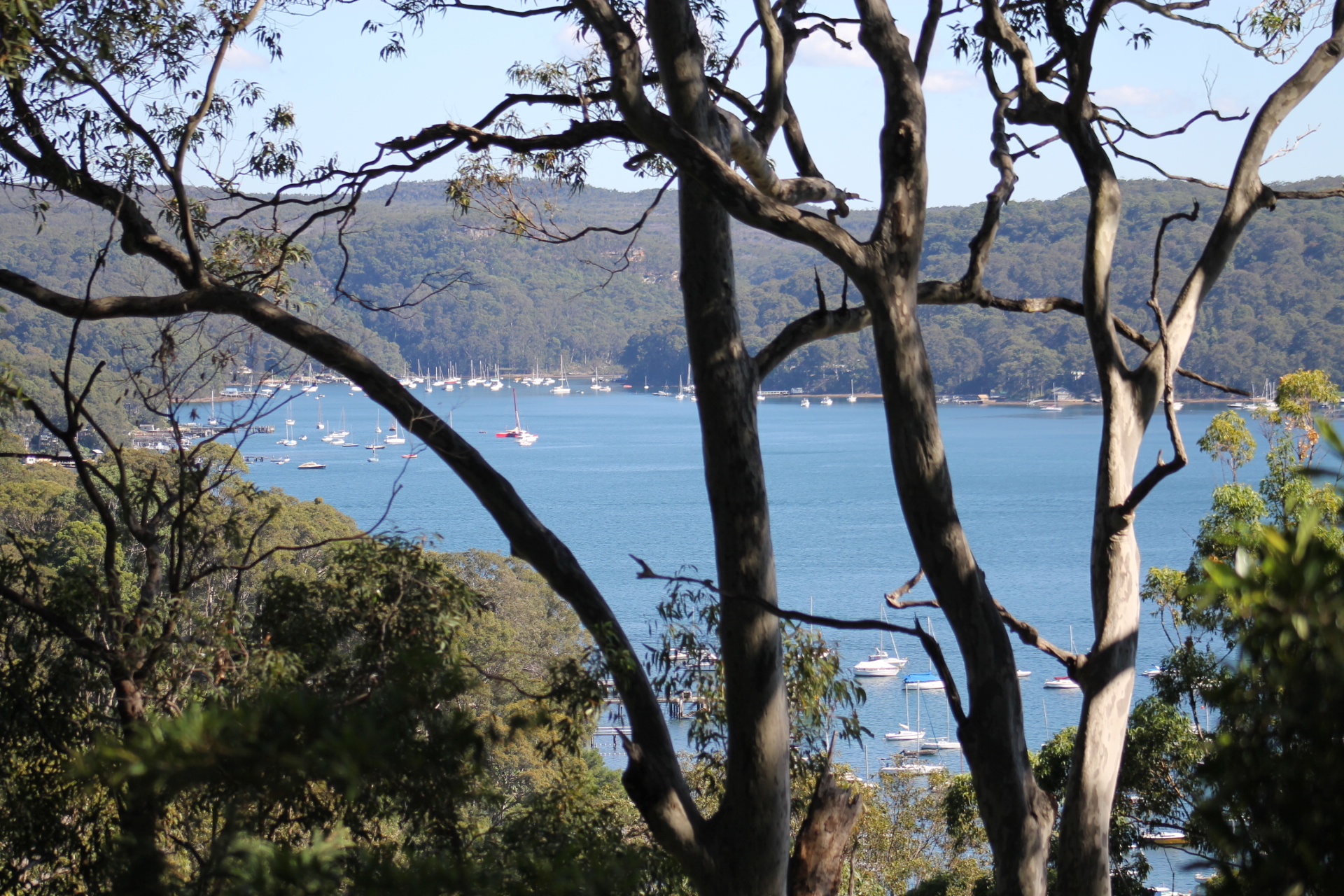
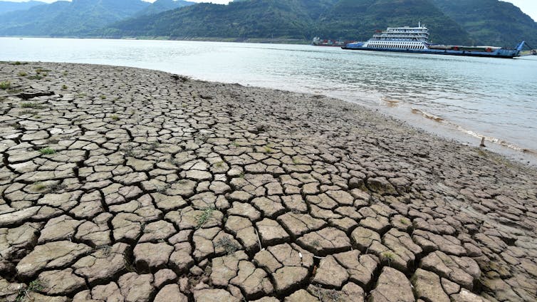
To the south east of Pittwater lies the waters of Winji-Jimmi Bay of Newport. An existing commercial marina formerly known to some as the Newport Marina was proposed to be demolished to make way for the construction of a new 9-berth marina, floating pontoon walkways, a new seawall, landscaping works and subdivision into 8 lots at a site known as 122A Crescent Road, Newport.

August 1 2025 runoff - photo supplied - details below

Commissioner Horton found it is relevant to note at the outset that the Newport Marina has been operating on land adjoining the subject site, known as Nos 122, 124, 126, 128 Crescent Road and 55 and 57 The Avenue (the adjoining site), also in the ownership of the Applicant in these proceedings, 57 The Avenue Pty Ltd (The Avenue).

On 6 December 2023, Northern Beaches Council granted consent to development application DA/2022/2152 for demolition works and subdivision of the land into 8 lots, tree removal and infrastructure works on the adjoining site.

The development, the subject of these proceedings, is that development described in development application DA2024/1409, lodged by The Avenue with Northern Beaches Council on 21 October 2024 seeking consent for the following:

  • Reconfiguration of the existing Marina to a nine-berth marina and subdivision into 8 lots;
  • Concept building envelopes for boat sheds on Proposed lots 5 and 6;
  • Associated landscaping and demolition removal of existing vertical slipway and boat ramp and extension to an existing seawall; and
  • Subdivision of the site.

The Council notified the development application in accordance with the relevant Community Participation Plan from 31 October 2024 to 28 November 2024, in response to which several submissions from residents were received.

The Council also provided preliminary feedback to The Avenue in February 2025. However, as the development application was otherwise undetermined, The Avenue appealed its deemed refusal on 19 March 2025 under s 8.7 of the Environmental Planning and Assessment Act 1979 (NSW) (EPA Act).

On the eve of the hearing, The Avenue sought to further amend the development the subject of the development application by Notice of Motion that sought, unopposed, to amend the proposal as follows:

  • Reduce number of berths from 9 to 8 – 6 of which are to be marina berths and 2 identified as water recreation structures.
  • Reduce the size of boat proposed, and reduce the lateral extension of structures into the waterway to reduce the development footprint and increase the area of rehabilitation of the foreshore.
  • Improve foreshore treatment and enhance visual amenity due to smaller hardstand area and foreshore repatriation, creation of intertidal benches and coastal riparian planting.

The Court granted The Avenue leave to amend the development application by relying on the following amended plans and other documents contained in the Notice of Motion:

  • Amended Draft Plan of subdivision (Exhibit B).
  • Amended architectural plans prepared by Scott Carver (Exhibit C).
  • Amended Landscape Plans prepared by Site Image (Exhibit D).
  • Amended Aboricultural Impact Assessment prepared by RainTree Consulting (Exhibit E).
  • Materials Investigation Report prepared by BG&E (Exhibit F).

In opening submissions, the Council advised the Court that 'as a result of the amendments to the development, being more than minor, those matters originally contended for by the Council in the Statement of Facts and Contentions filed 2 May 2025 are resolved other than the impacts on overhead electricity wires and a power pole located nearby but not within the site the subject of these proceedings'.

Development is, therefore, permitted with consent

The Council initially contended that the proposed development was not permissible as is it located partly within Zone W1 Natural Waterways zone within the Pittwater Local Environmental Plan 2014 (PLEP) and therefore constitutes prohibited development.

However, in its opening submissions, the Council took the Court to Sch 1 of the PLEP in which Additional Permitted Uses are identified within an area marked Area 23. Clause 23(2) of Sch 1 provides that, within Area 23:

23   Use of certain land in Zone W1 Natural Waterways

(2) Development for the purposes of boat sheds, jetties or water recreation structures is permitted with development consent.

The two proposed structures within the W1 zone are nominated as water recreation structures, defined in the Dictionary of the PLEP in the following terms:

water recreation structure means a structure used primarily for recreational purposes that has a direct structural connection between the shore and the waterway, and may include a pier, wharf, jetty or boat launching ramp.

As such, it was held that the two water recreation structures proposed within the W1 zone are development permitted with consent.

The site is located in an area identified in the PLEP as part W1 Natural Waterways and W2 Recreational Waterways. The site adjoins, and is generally surrounded by, land zoned C4 Environmental Living.

The objectives for development in the W1 zone are as follows:

1   Objectives of zone

  • To protect the ecological and scenic values of natural waterways.
  • To prevent development that would have an adverse effect on the natural values of waterways in this zone.
  • To provide for sustainable fishing industries and recreational fishing.
  • To ensure development does not adversely impact on the natural environment or obstruct the navigation of the waterway.
  • To provide opportunities for private access to the waterway where these do not cause unnecessary impact on public access to the foreshore.

The objectives for development in the W2 zone are as follows:

1   Objectives of zone

  • To protect the ecological, scenic and recreation values of recreational waterways.
  • To allow for water-based recreation and related uses.
  • To provide for sustainable fishing industries and recreational fishing.
  • To provide for amateur and professional recreational yachting or boating clubs and the like that serve Pittwater and the wider region.
  • To ensure development does not adversely impact on the enjoyment and use of the waterway or adjoining land.
  • To provide for a variety of passive and active recreational pursuits and water-based transport while preserving the environmental setting of the waterway.
  • To ensure that public access to the waterway and foreshore areas suitable for public recreational and transport purposes is maintained.

The site is identified at Section A4.15 of the Pittwater 21 Development Control Plan (Pittwater DCP) to be within the Waterways Locality, in which the following desired future character is described:

“The Waterway locality will remain primarily a recreational boating area. Waterfront businesses, yacht clubs and the like will meet the waterway recreational and boating needs of the community.

Future development is to be located so as to be supported by adequate infrastructure, including roads, water and sewerage facilities, and public transport.

Future development should ensure that access is available at all times to public boating facilities, such as launching ramps. Future development will not restrict public access adjoining the foreshore, or pedestrian access along the foreshore.

Future development will maintain a building height limit below the tree canopy and minimise bulk and scale. Existing and new native vegetation, including canopy trees, will be integrated with the development. Contemporary buildings will utilise façade modulation and/or incorporate shade elements, such as pergolas, verandahs and the like. Building colours and materials will harmonise with the natural environment. Development will be designed to be safe from hazards. Development will co-exist with adjoining residential areas. Development will not restrict public access adjoining the foreshore, and will not obstruct navigation within the waterway.

A balance will be achieved between maintaining the landforms, landscapes and other features of the natural environment, and the development of land. As far as possible, the locally native tree canopy and vegetation will be retained and enhanced to assist development blending into the natural environment, and to enhance wildlife corridors. Future development will include measures to ensure protection of the water quality and estuarine habitats of the locality, including mangroves, sea grasses, intertidal sand/mud flats, rocky shorelines, and beaches.

Heritage items and conservation areas indicative of the Guringai Aboriginal people and of early settlement in the locality will be conserved.”

Section D15.1 of the Pittwater DCP sets out the following outcomes for development sought in this locality when viewed from the public domain:

“To achieve the desired future character of the Locality.

To ensure new development responds to, reinforces and sensitively relates to the spatial characteristics of the existing built and natural environment. (En, S, Ec)

To enhance the existing streetscapes and promote a scale and density that is in scale with the height of the natural environment.

To ensure the visual impact of the built form above mean high water mark is secondary to landscaping and vegetation, or in commercial areas and the like, is softened by landscaping and vegetation. (En, S, Ec)

High quality buildings designed and built for the natural context and any natural hazards. (En, S)

Buildings do not dominate the streetscape or waterway and are at human scale. (S)

To preserve and enhance district and local views which reinforce and protect the Pittwater's natural context.

To enhance the bushland vista of Pittwater as the predominant feature of the landscape with built form, including parking structures, being a secondary component.

To ensure that development adjacent to public domain elements such as waterways, streets, parks, bushland reserves and other public open spaces, compliments the landscape character, public use and enjoyment of that land. (En, S)

Built structures are minimised below mean high water mark. (S)

A balance between use of the waterway and conservation of the natural environment is achieved. (En, S, Ec)”

For development on the seaward side of the MHWM, Section D15.12 contains controls that relevantly provide:

“Controls

Only structures associated either with the accommodation, servicing or provision of access to boats shall be permitted seaward of mean high water mark.

In instances where it is proposed to alter, extend or rebuild existing buildings seaward of mean high water mark, any further encroachment of such buildings onto the waterway is to be minimised. Where development seaward of mean high water mark is proposed to occur, especially during the refurbishment of existing structures, proponents need to ensure that the structure will not harm marine vegetation, and must consult with the Department of Primary Industries.

…”

To ensure that fair and equitable enjoyment of the waterway is achieved between neighbouring waterfront landowners, controls at Section D15.13 of the Pittwater DCP apply to what is termed the lateral limits and setbacks, including the setback of any vessel in the water.

Controls relating to waterfront development at Section D15.15 state that ramp and pontoon structures are preferred in place of jetties, where practicable, and provide for berthing areas and orientation.

Section D15.18 of the Pittwater DCP is also relevant to the development proposing seawalls. For completeness, these provisions at Section D15.18 are in the following terms:

“Outcomes

Any adverse impact upon the marine flora, fauna or water quality of the locality is minimised. (En)

Development has due regard for other existing water based activities in the locality, particularly those which have recreational, residential or economic significance. (S, Ec)

Alienation of public foreshore land below mean high water mark is minimised. (S)

The impact of development may on the physical processes acting in the locality is minimised. (En)

Development is sympathetic to the natural character of the Pittwater Waterway. (En, S)

The occurrence of dredging in the Pittwater Waterway other than for general navigation purposes is minimised. (En)

Controls

Seawalls shall not be permitted.

Variations

Council may consider the construction of seawalls where there is potential for erosion from coastal process and protection of property is necessary.

In such instances, the following criteria shall apply:

i. where possible, maintain the curvature of the existing shoreline;

ii. incorporate low profile walls, battered or stepped back from the foreshore wherever practicable, with a maximum recommended height of 1 metre above mean high water mark. (1.5 metres AHD);

iii. constructed of or faced in rectangular shaped sandstone, being either dressed or rough-cut in order to promote a uniform treatment along the foreshore. Alternative building materials, such as reconstructed sandstone concrete blocks or similar, which reflect a sandstone character shall also be suitable, particularly where greater structural strength may be required. Materials such as timber, concrete (including nylon mattress structures) gabions or other materials not in keeping with the character of the area shall not be permitted. Concrete/nylon mattress structures may be suitable for public drainage and associated bank stabilisation works where it can be demonstrated that such structures will not detract from the visual amenity of the locality.

iv. only clean fill is to be used behind sea walls.

v. where practicable, sandy beach areas should be incorporated in front of seawalls.

vi. be designed so that the existing footprint is maintained (i.e. does not encroach any further into the intertidal zone) and the seawall is sloped back towards the property. There must be no additional reclamation of water land (requires a permit from the Department of Primary Industries) or replacement of the existing wall with a vertical seawall;

vii. that there is no mortaring of the seawall and a geotextile fabric is used behind the seawall to prevent loss of sediment through the seawall;

viii. should be rock rip rap, boulders or similar complex structures, and where possible incorporate further vertical and horizontal complexity.

ix. maximise the incorporation of native riparian and estuarine vegetation;

x. create low sloping seawalls and/or incorporate changes of slope; and

xi. it is recommended that proponents consult with both the Coasts & Estuaries section of the Office of Environment and Heritage, and with the Aquatic Habitat Protection unit of the Department of Primary Industries.

xii. compliance with Environmentally Friendly Seawalls – A Guide to Improving the Environmental Value of Seawalls and Seawall-lined Foreshores in Estuaries (2009) available at the Office of Environment & Heritage website.

Within the Crystal Bay Foreshore area, the following controls shall specifically apply:

i. only dwarf seawalls shall be permitted along the foreshore of the Bay.

ii. be wholly constructed or faced in regular dressed sandstone blocks, reconstructed sandstone face blocks or reconstructed sandstone tiles; and

iii. have a battered slope located in front of it constituting the intertidal beach zone; and

iv. be flush to the top of the seawall with the reclamation located behind it (Diagram 1); and

v. not have a height greater than 0.75 metres above mean high water mark (1.26 AHD); and

vi. be aligned generally in a position which accords with the physical high water mark (Diagram 2) and form a continuous and uniform alignment with any existing adjoining, approved seawall.”

Foreshore Impacts are considered

A number of the contentions initially pressed by the Northern Beaches Council dealt with the likely environmental impacts of development proposed on or in the vicinity of the foreshore of Winji-Jimmi Bay.

In considering those contentions, the Court was assisted by experts in planning, Mr Stephen Gouge on behalf of The Avenue and Mr Nic England on behalf of the Council who conferred, along with Mr Rohan Dickson, expert on visual impact on behalf of the Applicant, in the preparation of a joint expert report filed with the Court on 17 February 2026.

The Court was also assisted by Mr Mark Kokot, expert in arboriculture on behalf of The Avenue and Mr Torin Calf, Landscape expert on behalf of the Council who conferred in the preparation of a joint expert report filed with the Court after close on 12 February 2026.

In considering those matters in respect of the environmental impacts on, and natural character of, the Pittwater waterway, the Court was assisted by Ms Katie Smythe, expert in ecology on behalf of The Avenue and Mr David Hellot, water management expert on behalf of the Council who conferred in the preparation of a joint expert report filed with the Court on 13 February 2026.

The judgement states that 'In short, the experts reached agreement on all matters in contention'.

And that 'In broad terms, the experts agree the demolition of the existing concrete hardstand and the alternative interface with the water by means of low-sloping rock revetment incorporating intertidal benches, varied rock sizes, habitat features and estuarine vegetation is an appropriate treatment when regard is had to the provisions at ss 2.10 and 2.11 of State Environmental Planning Policy (Resilience and Hazards) 2021 (Resilience and Hazards SEPP) that apply to the development (Exhibit 4, pars 46-47).

In particular, Mr England considers the reinstatement of around 28m of the foreshore, measured at the MHWM, to be an enhancement consistent with the objectives of the W2 zone that allow for water-based recreation and related uses (Exhibit 4, pars 49-51).

Likewise, the amendments summarised at are agreed to be both an appropriate footprint and lateral extension into the waters of Winji-Jimmi Bay and serve to improve the potential access to the foreshore by the public (Exhibit 3, par 62).

The reduction of that extension and in the number of berths, and the configuration of the berth areas to accommodate smaller vessels perpendicular to the shoreline, also significantly reduce the visual impact such that the objectives and outcomes sought by relevant provisions at Section D15 of the Pittwater DCP are achieved.'

The Council initially contended that fill associated with a retaining wall proposed to the north of the site would adversely impact three trees within the foreshore area, requiring their removal contrary to provisions dealing with development on foreshore area at cl 7.8 of the PLEP.

However, the Council also accepts that no development in this application is proposed between the foreshore building line and the MHWM. As such, the provisions of cl 7.8 do not apply to the proposal. This is because foreshore area is defined as the land between the foreshore building line and the MHWM of the nearest natural waterbody shown on the Foreshore Building Line Map.

Nevertheless, the affected trees are identified in the Amended Arboricultural Impact Assessment Report prepared by Raintree dated 20 February 2026 (Exhibit E) as follows:

  • Tree 64: a Eucalyptus capitallata or Brown Stringbark (T64).
  • Tree 66: Eucalyptus pariculata, or Grey Ironbark (T66).
  • Tree 69: Eucalyptus pariculata, or Grey Ironbark (T69).

The experts considered amended plans that showed the removal of proposed fill and retaining structures, and the area naturalised instead using soil, plantings, rocks and boulders. As a result of the amended plans, the experts agreed that the impacts on Tree 64 are minor and acceptable and while the impact on Tree 66 is classified as major, it is not necessary to remove it.

However, the experts agree the impact on Tree 69 is such that it will need to be removed. The Avenue proposes to replace it with two of the same species, Eucalyptus pariculata, or Grey Ironbark.

In respect of the estuarine habitat, the experts agree that the amendments incorporate measures that collectively enhance the habitat value of the site by virtue of the rock revetment mimicking natural shoreline conditions, providing intertidal benches to allow the colonising of this area by various ‘biodiverse assemblages’ and because of the enhanced visual amenity and stability of the shoreline provided by the riparian planting proposed.

In respect of the natural character, the judgement stated the experts once again rely on the rock revetment and riparian vegetation as the basis for agreement that the visual presentation is a significant improvement on the existing presentation and so improves the natural appearance of the foreshore.

In respect of the seawall design and slipway, the judgement found 'the experts cite conformity with a document titled Environmentally Friendly Seawalls: A Guide to Improving the Environmental Value of Seawalls and Seawall-lined Foreshores in Estuaries, Office of Environment and Heritage on behalf of Sydney Metropolitan Catchment Management Authority (June 2009) as the basis for agreement that the proposal is consistent with the provisions of Section D15.18 of the Pittwater DCP'.

A recurring concern of residents arises from what is described by them as poor design and technical compliance of the berth locations and layout, and the risks associated with variables like wind, tide, depth and turning circles of vessels in the vicinity of the proposed berths.

One submission expressed concern at the proximity of the proposed development to that of the berthing area at 50 The Avenue. However, Commissioner Horton noted the Navigation Report includes this vessel in its assessment and that subsequent amendments propose vessels of no more than 9m x 5m to those water recreation structures at Lots 7 and 8.

In respect of safety concerns held by a resident opposite the site, the Court observed that 'fire service requirements are contained in Section 6 of AS3962:2020, and the Court is advised the Rural Fire Service operates fire fighting vessels'.

Inconsistency of the development with the residential character of the area and overdevelopment of the site, impacts of the development upon significant trees, traffic and parking impacts along with vehicular access, remain contentious points with residents.

The full judgment and decision may be accessed here.

The modified documents may be found on the council webpage for Section 455 Modifications Mod2025/0220 here

Developments are now often approved by the Land and Environment Court, bypassing community objections. Local residents associations state that the detailed judgement and amended plans should go on the Council website. 

However, it is part of the legal process that both parties need to agree to the publication of these documents as they are not Court documents which are generally made available. Therefore, the modifications referred to in the above judgement are not, as yet available on the council website.

Modifications to development applications are normally not notified to nearby residents even though they might have a considerable impact on neighbouring houses. Many state that they should be treated in the same way as the original development application and neighbours notified. At present, only those who have made a submission are advised of a modification by the council posting them a letter. 

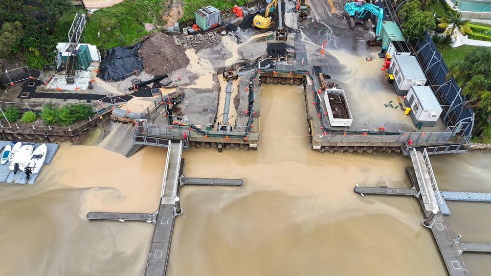
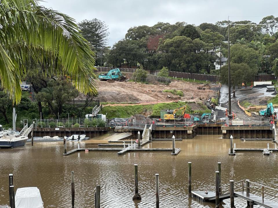
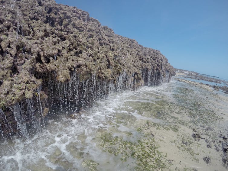
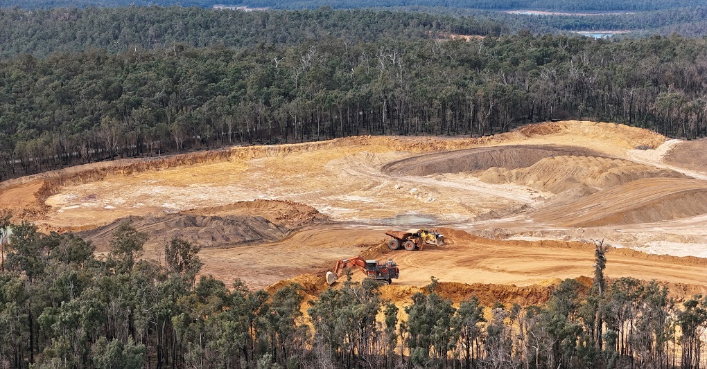
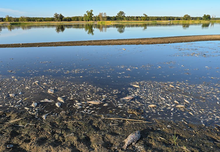
Worth noting is this item sent in last August:

Newport job site: run off into Pittwater

Dear Editor

This is the old Sirsi Marina at the Crescent Road Newport on August 1 2025 - every time it rains this is what washes into the Bay. Council have warned them but still it happens. This affects all the fish, people, kayaks, dragon boats, sailors, and birdlife that enjoy the bay.  And the development that they are still trying to get approved is for 8 houses with 9 x 22 meter boats that will intrude further into the bay past these original pens.

Pittwater Resident, August 2, 2025


Update on Heard Island’s H5 bird flu outbreak

Friday, 27 February 2026: by BirdLife Australia

Scientists onboard the research vessel RSV Nuyina have returned from a second expedition to Australia’s Heard Island in the remote sub-Antarctic and have confirmed that H5 bird flu is spreading among the island’s wildlife. The virus was detected in samples from Southern Elephant Seals, Antarctic Fur seals and Gentoo Penguins. 

At this stage we don’t know how many Gentoo Penguins are affected or whether other bird species on the island have also contracted the virus, owing to the difficulties associated with monitoring species on remote sub-Antarctic islands. Expedition scientists have reported that they didn’t observe any signs of mass mortality in mammals or birds while they were on the island. Data from aerial surveys is currently being analysed by scientists and may reveal a clearer picture about the extent of the outbreak.  

While there is still much we don’t know about the impact H5 bird flu will have in these remote Australian territories, it’s clear that Australia has reached a bleak milestone. 

According to Dr Yuna Kim, BirdLife Australia’s Seabird Project Coordinator, it is difficult to predict the possible impact of H5 bird flu on the island’s bird populations, including the Heard Island Shag (Leucocarbo atriceps nivalis) and Heard Island Sheathbill (Chionis minor nasicornis). 

“Experience from other Antarctic regions shows that impacts vary significantly by species and location.” Dr Kim says that lacking the baseline data needed to assess disease related mortality and population level impacts from threats such as H5 bird flu is an ongoing challenge in seabird conservation, and that long-term monitoring programs are required to address it. “The detection of H5 bird flu highlights an opportunity to strengthen long term monitoring of seabird populations at priority sites such as Heard Island”. 

Although Heard Island is over 4000 kilometres away, it is considered to only be a matter of time before the virus arrives on the Australian continent. Migratory seabirds such as Skuas, with their scavenging behaviour, give them a higher likelihood of carrying H5 bird flu closer to the mainland, and to other Antarctic colonies such as the incredibly wildlife-rich haven of Macquarie Island. 

While there is still much we don’t know about the impact H5 bird flu will have in these remote Australian territories, it’s clear that Australia has reached a bleak milestone. 

 “The Gentoo Penguins of Heard Island are now the first birds in an Australian territory to test positive for this virus that has devastated wildlife around the world. They will certainly not be the last,” said Professor Hugh Possingham, Vice President BirdLife Australia. “This confirmation is a critical reminder that Australian birds remain at risk”. 

While Australia remains on watch for signs of H5 bird flu, we can all play a part in the preparedness effort by following these steps: 

Avoid, record, report. Avoid contact, record and report any signs of unusual sickness or death in waterbirds, seabirds or shorebirds. Raptors around water such as white-bellied sea eagles and ospreys could also be vulnerable.  For more info see here. 

The looming threat of H5 bird flu must sharpen our focus on protecting Australian birds and the habitats they depend on. Healthy bird populations have the best chance to withstand the effects of mortality from H5 bird flu outbreaks. Everything we do as an organisation and a community to protect waterbirds, seabirds and shorebirds is vital preparation.

Family of Gentoo Penguins. Photo: Antoine Lamielle, 2020

Boguls Being Returned to local Bush Reserves

Boguls are coming back to northern Sydney!

During February and March 2026, we’ll begin reintroducing the bogul (Dharug language) - the native bush rat (Rattus fuscipes) - to bush resreves at Twin Creeks (at Turramurra) and Allenby Park (Allambie Heights, Beacon Hill and Brookvale) and bolstering a population at North Head (Manly).

Small but mighty, boguls help suppress invasive black rats and disperse seeds, pollen and fungi - restoring balance to urban bushland.

This ARC Linkage project is delivered with researchers from the University of Sydney and Macquarie University, alongside the Taronga Zoo Sydney Conservation Society and NSW Government agencies.

Project lead: Mareshell Wauchope with University of Sydney's Rewilding Project

Follow along as we get closer to release!: sydneyrewildinginitiative.com

More in:

Translocation and reintroduction of native bush rats (Rattus fuscipes) into Sydney Harbour National Park : restoring ecosystem function  by Megan Callander, Western Sydney University, Western Sydney University thesis: Doctoral thesis, 2018

Abstract

With habitat destruction and invasive species comes the loss of biodiversity and ecosystem function. Animal translocations and reintroductions are one of the key options available to conserve and restore wildlife populations and ecosystems. Translocation is relatively new within the broader context of conservation and has only become a commonly used scientific tool within the past 40 years, as such, there are no definitive guidelines for best practice. Wildlife translocations and reintroductions are complex, expensive, and time-consuming, often meaning that many of them fail to establish viable populations. The low success rate has been attributed to inadequate knowledge of species-specific behaviour, poor release site selection, environmental pressures, predation, competition and stress. Monitoring populations after reintroduction is important to identify the success or potential causes for failure, to adapt and improve management strategies. Ideally, successful translocation is indicated by the ability of the translocated, or augmented population, to become self-sustaining, free-ranging and viable in the long term. 

The Bush Rat Project was the first study to translocate and reintroduce the native bush rat (Rattus fuscipes) into Sydney Harbour National Parks (SHNP) in an attempt to restore the ecosystem and reduce invasive species (black rat, Rattus rattus) populations. 100 bush rats (60 females and 40 males) were released in August 2011 into four sites in SHNP. Bush rats were released in familiar groups and 20 animals were radio tracked for two months. Nine trapping sessions were conducted, the last in May 2014. Ear tissue was taken from all bush rats for use in microsatellite genetic analysis. Sibships and parent-offspring relatedness were determined through this process. Prior to bush rat release each of the four sites were intensively trapped for ten nights to remove black rats. 

Using these methods, factors that influenced bush rat translocation success were examined, including sex, body condition, weight, virus status, dispersal and establishment of home range, genetic relatedness and structure. These factors were assessed in relation to population dynamics and survival rates, breeding success and habitat. Possible biological control of an invasive species via competition was also examined by comparing persistence of bush rats to number of black rats, avoidance patterns and spatial segregation. Success of translocation in this study can be shown through sex, reproduction, body condition, habitat suitability, site fidelity, relatedness and competition. In the initial stages (within the first year), populations of bush rats had established on all sites and juvenile recruitment occurred, indicating survival, growth and evidence of reproduction. Over the entire study period bush rats persisted in three of the four sites but the remaining numbers were low (less than the numbers released), thus maintaining a viable, self-sustaining population would be difficult. Although animals remained after three or four generations, long-term persistence could be affected by major environmental change or demographic stochasticity if populations remain small. 

Common species are important in ecosystem structure and function. Declines in their abundance and distribution can lead to loss of less common species and ecosystem function. Wildlife restoration and thus ecosystem function can be restored to ecosystems that are biodiversity poor or have a high element of invasive species. Wildlife restoration increases the functional diversity of remnant habitats, making them more resistant to invasion. As well as being far more cost-effective than reactive management in reversing declines, this proactive approach also helps to determine underlying mechanisms that are required for successful translocation, thus, producing best practice for the reintroduction of rarer species. 

Bush rat reintroduction into SHNP uses the wildlife restoration concept to reintroduce a common species to restore ecosystem function, increase biodiversity and control invasive species. Bush rats are good candidates for translocation and reintroduction, because they are adaptable and not endangered, therefore can be safely used for multiple reintroductions. Bush rats existed in SNHP as recently as 100 years ago and have conspecifics close by in comparable habitats. They can be sourced from original sites and usually display a rapid population recovery. Therefore bush rat characteristics make them ideal for investigating translocation, colonisation, recovery and competition, within a fragmented habitat. 

The sites in this study are too new, therefore more introductions to stabilise population would assist bush rat persistence if changes in the environment occur. This is supported by other studies that have shown that repeated releases of large numbers of individuals were generally required to successfully establish a translocated population and create a self-sustaining ecosystem where minimal intervention is required. Wildlife restoration via bush rats creates a situation in which less resources need to be invested in ecological management, as the environment will eventually be capable of self-maintenance. Thus, creating a self-sustaining ecology that does not require further interventions. By reintroducing locally-extirpated animals into modified landscapes, wildlife restoration is a proactive approach that will maintain biodiversity, ecosystem function and avoid future species decline.

Help protect the Red Goshawk from extinction

The endangered Red Goshawk is Australia’s rarest bird of prey.

They are rusty red, stealthy, high-speed hunters, with powerful talons perfectly adapted for catching prey mid-flight – put simply, they’re extraordinary.

They’re a specialist hunter, and where they occur is a sign that Country is healthy.

But today, this endangered bird is disappearing.

BirdLife Australia says:

''There are now less than 1,000 Red Goshawks, with the remaining population largely confined to northern Australia, including the Pilbara region, Top End, and Cape York Peninsula.

Despite their formidable nature, Red Goshawks are likely completely lost from New South Wales and southern Queensland.

Hot wildfires are burning down the tall trees they rely on for nesting. These fires also alter the structure of the forest, reducing their ability to effectively hunt the prey they need to survive. Ongoing land clearing further shrinks the areas of suitable habitat left for Red Goshawks.

Help us protect their habitat, strengthen partnerships with Indigenous rangers, and secure a future for this remarkable bird.

Without help, we are facing a world without the Red Goshawk. Please donate today and help protect what’s left.''

Donate here

The red goshawk (Erythrotriorchis radiatus) is a bird of prey found in Australia. It is found mainly in the savanna woodlands of northern Australia, particularly near watercourses. 

The red goshawk was first described by the English ornithologist John Latham in 1801 under the binomial name Falco radiatus.

Plumage is generally rufous; on the head streaked with black and white, having more white on the face and throat; on the upper surfaces (body and upperwings) marked with black. Flight feathers and tail are barred grey, dark above and light below. Underside (belly and underwing coverts) are rufous with slight black ticking. The female has a paler belly than the male. Juveniles (first year) have less streaking on the head.

Red Goshawk male in York Peninsula. Photo: JJ Harrison 

Red Goshawk female in York Peninsula. Photo: JJ Harrison 

Wings are long, broad and fingered at the tips. Its tail is long and broad; square-tipped and about half its total length. It has a robust bill, slight brow ridge, and very heavy feet with bare tarsi having scutellate scale pattern. 

Pattern of direct flight is described as "sometimes leisurely, rather heavy and crow-like, with sustained flapping". Pursuit is "powerful and energetic with deep, fluid wing beats, like a fast-flying Brown Falcon". It soars with wings raised in a slight dihedral, almost flat; glides with wings flat or slightly bowed; and sometimes stoops with closed wings.

Size is 45–60 cm long, with 110–135 cm wingspan. Males weigh 635 g, females 1100–1400 g. The female is similar in size to a whistling kite, and the male to a female brown falcon.

The nest is built in an exposed fork of a tall emergent tree. It is a stick platform lined with green leaves, 60–120 cm across and 30–50 cm deep.

The egg-laying season is from May to October in the tropical north, and August to October in the east. Incubation takes 40 days, the nestling period 51–53 days, and juveniles remain dependent for 2–3 months.

Red Goshawks inhabit open woodland and forest, preferring a mosaic of vegetation types, a large population of birds as a source of food, and permanent water, and are often found in riparian habitats along or near watercourses or wetlands. In NSW, preferred habitats include mixed subtropical rainforest, Melaleuca swamp forest and riparian Eucalyptus forest of coastal rivers.

Adults appear to occupy territories throughout the year and breeding territories are traditionally used from year to year. Adults have large home-ranges, estimated in the Northern Territory to be as great as about 120 km2 for females and 200 km2 for males.

Red Goshawks mainly eat medium to large birds, including species as large as Australian Brush-turkeys, Kookaburras, Tawny Frogmouths, Sulphur-crested Cockatoos and Rainbow Lorikeets, but they also take mammals, reptiles and insects.

In NSW

The Red Goshawk (Erythrotriorchis radiatus) is listed as an Endangered species in NSW as of December 2023, having been upgraded from previous listings due to a severe range contraction and population decline. 

A Saving Our Species conservation project is currently being developed for this species and will be available soon. For information on how you can contribute to this species' recovery, see the Activities to assist this species section below. - from OEH webpage updated 14 Oct 2024

Macro Lenses Let you see details of hidden worlds

Finally bought a macro lens, a cheap $200 version, not the one that costs thousands, and had a test out this week. Although the first two subjects and photos aren't great, professional photographers have shared they often take several photos to get one good one - worth bearing in mind if you like taking photos and want to get into it more.

Macro lenses are specialised optics designed for extreme close-up photography, offering 1:1 (life-size) or higher magnification to capture intricate details with superior sharpness from a safe, non-disturbing distance. 

So in the instance of this white moth with yellow markings and two dots on the wings, you get to see that it actually has four wings - or the tiny little black ants - you can see they're having a bit of a conversation about something or other as the whole nest gathers food.

These images also make it easier to look up what species you're actually finding in your garden. Simply upload the image to Google Lens and find out more.

The moth is actually a Notarcha aurolinealis moth, also known as the yellow-lined moth. 

It is found in various locations including Hong Kong, Thailand, and parts of New South Wales. Specimens of this species have also been found in  Western Australia, the Northern Territory, and Queensland.

The snout moth species belongs to the Crambidae family. The name 'Notarcha aurolinealis' was given by Francis Walker, in 1859. 

Notarcha chrysoplasta and Notarcha polytimeta are also found in Australia, but records show they have only been seen and photographed in Queensland and the Northern Territory so far.

Notarcha chrysoplasta. Photo: Ian McMaster via iNaturalist

The name is derived from the Greek words notos (back/south) and archos (ruler/leader), often interpreted in scientific naming to reflect distinctive markings on the back or thorax of the insect, or/and referring to its geographic origin.

The name aurolinealis is derived from a combination of Latin and Neo-Latin terms describing the appearance of the moth, from Auro- (Latin aurum) meaning "gold" or "golden" and -linealis (Latin linea) meaning "linear" or "line," often used in entomology to indicate the presence of lines or stripes.

Notarcha is a genus of moths in the family Crambidae described by Edward Meyrick in 1884 - an indication those that come afterwards often build on the work of those who worked in the same field prior to them.

The family name Crambidae is derived from the New Latin genus name Crambus (from Greek krambos, meaning dry or parched, likely referring to their habitat or appearance), combined with the standard zoological suffix -idae to denote a family.

Crambidae comprises the grass moth family of lepidopterans. They are variable in appearance, with the nominal subfamily Crambinae (grass moths) taking up closely folded postures on grass stems where they are inconspicuous, while other subfamilies include brightly coloured and patterned insects that rest in wing-spread attitudes.

Francis Walker (31 July 1809 – 5 October 1874) was an English entomologist. He was one of the most prolific authors in entomology, and stirred controversy during his later life as his publications resulted in a huge number of junior synonyms. His assiduous work on the collections of the British Museum had great significance.

Between June 1848 and late 1873 Walker was contracted by John Edward Gray, Director of the British Museum, to catalogue their insects (except Coleoptera) that is Orthoptera, Neuroptera, Hemiptera, Diptera, Lepidoptera and Hymenoptera. 

Walker is notable in the present time for the large number of synonymous taxa he described. A careless taxonomist by today's standards, he often gave more than one name to the same species. In this respect, however, he was no worse than many entomologists of his time; what makes for the more common occurrence of Walker's taxa in synonymy is the sheer volume of his work.

Edward Newman described him as the "most voluminous and most industrious writer on Entomology this country has ever produced" and said of him:

"I never met anyone who possessed more correct, more diversified, or more general information, or who imparted that information to others with greater readiness and kindness."

Kenneth G.V. Smith wrote: 

''[Walker's] 'Catalogues of Insects in the British Museum Collections' will always stand as a tribute to his industry. Walker (1836) also described the Diptera from Captain P. P. King's collection made on the first surveying voyage of Adventure and Beagle. Fortunately, many of his descriptions of Darwin's insects will endure because they were of little-known groups from little-worked regions and most of his types are still in the British Museum (Natural History).''

The Notarcha aurolinealis moth typically has a wingspan of approximately 1.5 cm to 20 mm. The moth has white and yellow patterned wings with one black dot near the centre and three on the costa of each forewing. 

The Caterpillar is green with a brown head. It has been found in a shelter made by rolling a leaftip of its foodplant, Paddy's Lucerne.

The larvae feed on Sida rhombifolia, a perennial or sometimes annual plant in the Family Malvaceae, native to the Old World tropics and subtropics. Other common names include 'rhombus-leaved sida' and 'Paddy's lucerne'. Sida rhombifolia is native to tropical and subtropical areas of Africa through India and southeast Asia to Japan, as well as Indonesia and the Philippines. It has been introduced to tropical and subtropical parts of both north and south America, Australia, islands of the Pacific, and some parts of Europe.

So.... there will be more and hopefully better closeups of the beauty in these hidden worlds after we've figured out a little bit more on how these macro lenses work - it's amazing stuff and allows us to find out more about what is living here in the garden and what comes into the house.

Pioneering entomologist gifts $12.6m to create Sydney Insect Hub

Professor Aola Richards' donation to advance insect research.

March 7 2026

A bequest of $12.6m from Professor Aola Richards, a remarkable pioneering entomologist, whose research fundamentally shaped our knowledge of Australasian insect fauna, is creating the Aola Richards Sydney Insect Hub at the University of Sydney. 

Professor Aola Richards with Giant Weta, New Zealand, photo by Steve Rumsey. Te Papa (E.006714)

“Professor Richards, the first woman in New Zealand to gain a PhD in biology, who went on to a lifetime of achievement in insect study, has entrusted us with her vision of continuing important research in this field, including with critical funding for early- and mid-career researchers, and the appointment of a Chair,” Vice-Chancellor and President Professor Mark Scott said.  

“We are deeply grateful for this donation to the University, establishing the Sydney Insect Hub. Insects sit at the centre of most terrestrial ecosystems and hold a deep fascination for the general public. The generosity of Professor Richards will allow us to continue her mission to contribute meaningfully to urgent matters in biodiversity, conservation and sustainability across Australia and globally.” 

Professor Richards specialised in Australian ladybird beetles and New Zealand cave wētā (crickets), once spending seven weeks underground in the Waikato caves of New Zealand, with only cave wētā and water rats for company. The wētā, which can measure up to 35cm (from antennae tip to back legs) avoid light so Aola had to turn off her torch for extended periods and observe them in the dark. 

She was a key figure in connecting entomology research with the scientific study and exploration of caves (speleology) in Australia and New Zealand. She studied cave crickets and glow worms in the caves of Tasmania and also studied fauna in the huge caves  beneath  the Nullabor Plain, driving a Land Rover across Australia accompanied by two students.

She spent 33 years in the Biology Department at the University of New South Wales and published more than 80 papers, many as sole author. She described over 20 new species while making discoveries about insect behaviour and ecology. 

“This donation allows us to build on the outstanding work of our current entomologists at the University by advancing insect ecology, evolution, genomics and applied entomology. It will also support sustainable agriculture, an issue Professor Richards strongly believed entomologists could play a leading role in, as well as biodiversity and biosecurity,” said Associate Professor Thomas White, Inaugural Chair of the Sydney Insect Hub. 

“Her enduring legacy will not only be her remarkable body of work that anchors modern taxonomy and natural history but this generous act to secure the future of her field.  It is Australia’s first hub dedicated to training the next generation of insect scientists through training, scholarships, fellowships and grants, working across the full breadth of entomology.”

Professor Richards bequest will be applied to research on:

  • how insect pollinator communities function and can be harnessed for sustainable agriculture including biological control
  • tackling invasive species ecology and biosecurity threats, including the impact of invasive parasites on the viral landscape of honey bees
  • how insects perceive their world, evaluate options and translate information into action
  • how invertebrate communities and ecological networks persist under environmental change, and how to conserve not only species but the interactions that sustain ecosystems
  • understanding insect ecology and evolution in a changing world 
  • advancing taxonomy, classification, natural history and species discovery.

“Aola Richards achieved excellence in entomology at a time when the field was heavily male-dominated. She devoted her life to deepening our knowledge of insects and her ground- breaking research is an inspiration. She is truly one of the giants of Australian entomology and her legacy of excellence will now also live on through her generous bequest,” said Associate Professor Tanya Latty, from the Faculty of Science and Sydney Insect Hub. 

Meanwhile Professor Richards’ gift is already supporting entomology students following the completion of their higher degree by research. 

Two beneficiaries of this funding have been Dr Braxton Jones,  the only Australian scientist wholly dedicated to studying stick insects and Zhuzhi Zhang, who works on cockroach phylogenetics (evolutionary relationship between organisms). 

Dr Jones is receiving funding from the Aola Richards Bequest to substantially support his three-year National Taxonomy Research Grant Fellowship. 

"The generous funding has allowed me to continue my research focused on discovering new species of Australian stick and leaf insects, focusing on arid adapted species." 

Sydney Insect Hub team

  • Associate Professor Thomas White (Chair)
  • Associate Professor Tanya Latty
  • Professor Dieter Hochuli
  • Professor Nathan Lo
  • Dr Emily Remnant
  • Dr Timothy Lee
  • Dr Ros Gloag

Further biography: Millions gifted to Three Universities

Professor Aola Mary Richards (1927–2021) was born December 16 1927, in Wellington, New Zealand, the only child of Hinemoa C C Hopkins, a lawyer, and David James Richards, a university mathematics professor from Wales. In Wellington she trained in zoology, completing an MSc in 1954 and, in 1958, becoming the first woman in New Zealand to earn a PhD in biological science. She worked at UNSW for more than three decades before retiring to London in 1994. A cave wētā species, Miotopus richardsae, was named in her honour in 2018. 

She described five genera from New Zealand and more than twenty new species comprising almost all of the known Australian taxa. 

In Australia, Richards also studied ladybird beetles. Her taxonomic work is highly cited and her studies of feeding biology revealed novel plant-insect interactions. Richards and her colleague Filewood were the first to describe how beetles can avoid toxic plant compounds by chewing through the leafstalk of their food plant. Referred to as "trench warfare", this behaviour allows ladybird beetles to isolate a region of the plant, preventing toxic plant compounds reaching them.

Aola left significant bequests to her alma mater, then Victoria College of the University of New Zealand (now Te Herenga Waka—Victoria University of Wellington), the University of Sydney — and the Department of Zoology at the University of Cambridge. 

Aola’s father went to Trinity College and Aola had the ambition to do postdoctoral work with V.B. Wigglesworth, a leading entomologist and Quick Professor of Biology at the University. Circumstances prevented this plan’s coming to fruition, however, so she developed her entomology research in Australia and New Zealand instead – even living in a cave with the wētā to better study them.

Malcolm Burrows, Emeritus Professor of Zoology at Cambridge’s Department of Zoology, recalls meeting Aola for the first time at a dinner party and their ensuing 30-year friendship: ‘Our relationship was very much based on the science, and she was a trove of stories about her work. She kept her private self buried quite deep, however. It may well have been because of her experience as one of the only women in a very male-dominated academic environment, which largely wasn’t fair to women at that time. She was certainly determined and thick-skinned, and a good scientist.’

Aola never forgot the opportunity to study at Cambridge University that had slipped through her grasp. She decided to make it possible for other students to fulfil their dreams. The £5m Aola Mary Richards Fundannounced in 2024, will be one of the biggest departmental postgraduate funds in the whole University. It will further education and research in the zoological sciences by supporting studentships for PhD students and research grants for postdoctoral researchers, called respectively Aola Mary Richards Studentships and Aola Mary Richards Grants.

Professor Richards’ estate has contributed to two other institutions globally. The School of Biological Sciences at Te Herenga Waka—Victoria University of Wellington has received a transformational $13.5 million (NZ $) gift and she has generously also left the University of Sydney $12.6 million, or an additional $13.5 million (NZ $). She gifted much of her insect collection to the CSIRO.

Aola Richards passed away November 2 2021 at the age of 93.

Reef Pods

This week the team at Sydney Institute of Marine Science's Project Restore installed their Reef Pods at 4 sites across Sydney Harbour; Vaucluse, Bottle & Glass Point, Parsley Bay and Watsons Bay. 

This is a key component of the project to achieve fish habitat enhancement through specifically designed and positioned Reef Pods. This initiative explores innovative approaches to increasing marine biodiversity and supporting native species on Sydney Harbour. 

The Reef Pods are expertly designed by the Reef Design Lab. 

This work is all made possible by the generous funding from the  NSW Trust and in partnership with the NSW Department of Environment and Heritage as part of the Seabirds to Seascapes Program.

 The Reef Pods initiative aims to explore new ways to increase marine biodiversity and support native species in Sydney Harbour.

Photo: Project Restore

About Project Restores' Reef Pods Project

Sydney Harbour’s natural benthic habitats such as rocky reefs have been reduced and degraded as the harbour has become urbanised, with over 60% of the foreshore lined with seawalls and docks. This has reduced fish habitat complexity and opportunity to breed and grow.

The University of Technology Sydney Fish Ecology lab has researched the impacts of artificial structures on fish and fisheries. This has included impacts of offshore oil and gas infrastructure a well as coast and benefits of breakwall structures and legacy WWII sunken infrastructure.

This led to a 2018 collaboration with the Sydney Opera House (SOH), where the team installed a series of small “reef pods” near the walls of the SOH, and since then surveys of the reefs have shown that the introduction of the reefs has enhanced fish assemblages in the area. This includes the sighting of new species including the endangered White’s Seahorse. 

Building on this success Project Restore will use “reef pods” in arrays at a number of nearshore sites in outer Sydney Harbour. Pairs of the units will be spread 10m apart to create new complex hard substrate habitat in areas where rocky reef have been degraded.

It is expected the new habitat will promote benthic habitat growth and increase fish biodiversity Regular surveys using underwater transects and stationary GoPro videos will reveal the fish life at these sites compared to nearby control sites.

Created in partnership with Reef Design Lab these units are designed to mimic the natural environment and encourage algal growth. The swim throughs and details are carefully designed to create areas of refuge and complexity for marine species to utilise. Once in place, Reef Pods will increase complexity and vertical relief in areas where rocky reefs have been degraded by urbanisation and siltation. This will create new refuge and breeding ground areas for marine biodiversity, and promote native shellfish and algae growth.

Project Restore aims to combine the methods and technologies of four SIMS flagship projects, which to date have operated largely independently of one another.

Together, these key projects provide a template for restoration of whole seascapes within urban harbours and waterways:

  • Operation Posidonia
  • Operation Crayweed
  • Living Seawalls
  • Fish Habitat enhancement

See February 2026 Update: Project Restore at Balmoral: Modern Moorings May Protect Sydney’s Endangered Seagrass

Or February 2025 report: Project Restore: seagrass from Palm Beach Going to Sydney Harbour - Join the Storm Squad + Environmentally Friendly Moorings – Free Trial Available

Find out more about how you can support these projects or get involved, at: projectrestore.sims.org.au

March 2026 at Kimbriki

Mondays to Thursdays:

Tuesdays: Avalon Boomerang Bags
November 5 2025: 
It is with great sadness that we announce that we can no longer operate out of the community centre in Avalon after 10 wonderful years, as we are finding the rent too expensive. 

We will move to The Hub at Kimbriki Resource Recovery Center in January 2026 and would still love you to come and visit us there, drop off fabric or buy a bag. We will be there on a Tuesday from 11-3pm.


ECO WORKSHOP – Beginners Composting & Worms
Composting and worm farming are great alternatives to disposing of your food waste in the rubbish bin while creating natural fertiliser for your garden. By recycling food scraps in a compost bin or worm farm you can help reduce organic waste disposed in landfill, in turn reducing the production of leachate and greenhouse gases from landfills. Compost and worm ‘castings’ are both ideal natural fertiliser for your garden.

*Northern Beaches Residents attending the entire Composting & Worms workshop: Northern Beaches Council would like to support its residents in recycling food waste at home by giving you a voucher towards buying a worm farm or compost bin. Northern Beaches Council will issue a $90 voucher to Northern Beaches residents who attend a Kimbriki Composting and Worms workshop and who have not had a free worm farm, compost bin or voucher from Council in the past. One voucher per household (not per person) is issued irrespective of number of workshops attended. The vouchers are issued directly from Council after you have attended the workshop. Please allow up to 3-4 weeks for the voucher to be issued and posted to your residential address. Voucher can be used at New Leaf Nursery in Ingleside or at the Kimbriki Eco House & Garden Eco shop.

Polystyrene Drop Off Collection Day
Venue: The HUB, Kimbriki (1 Kimbriki Road, Ingleside 2101)
Halfway down the hill on the left-hand side
Northern Beaches Council are encouraging residents to bring their rigid pieces of 100% clean, white and dry expanded polystyrene (EPS) used for packaging of appliances and electronics to Kimbriki Resource Recovery Centre for recycling on our collection day for free.

The polystyrene must not be contaminated with dirt, soil, tape, concrete, food, labels, plastic cardboard, ink printing and no bean bag beads to ensure the product can be recycled.
If you can bend the polystyrene and it snaps then it is EPS.

Waste & Sustainability in Early Childhood Centres
The day has been developed in line with the Early Years Learning Frameworks with particular focus on the new sustainability principle incorporated into the frameworks.


Whether you have been engaged with sustainability at your centre for some time or are just beginning to engage in response to the revised frameworks, there will be plenty on offer for all to engage further and learn from each other. We advocate for a shared and collaborative approach in this professional development day, which will allow educators to build confidence in integrating sustainability into their centre’s everyday activities and programs; learn from case studies from other centres; hear from guest speakers who can support your programs in biodiversity and water saving gardening; provide guidance on setting up effective systems at your centre to minimise and manage waste and access to a whole host of resources to take back to your centre.

Includes:
  • 5 hours of educator elected professional development, meeting standards appropriate to your context and needs and contributes to your ongoing professional learning
  • Morning tea and light lunch
  • Goodie bag
  • Lucky door prizes
  • Mountains of opportunity for collaboration and support 😊
To book immediately & receive an invoice/receipt for your credit card payment click “BUY TICKETS”  and fill in your details and to proceed to the check out.

If you prefer an invoice to be sent to your Centre, Email Event Organiser –  ECO.house@kimbriki.com to send us your request. We will send you a Booking Form to complete and return to us with your Purchase Order. Your place will be held and an invoice will be issued.

Council's Wildflower Project + Bushcare Volunteers

The council are stepping up to promote habitat by finding areas to re-wild suitable council-owned public land with meadows of low growing native wildflowers and grasses.


The following council information provides an overview:


What is it?

We're looking to re-wild some suitable Council-owned public land with meadows of low growing native wildflowers and grasses.

Where?

On Council-owned land which is currently being mown and offers little recreational use - such as road verges, around bus stops, council strips and edges of reserves.

Why?

Flowers and grasses benefit the environment in many ways - increased biodiversity, habitat for fauna, and assisting ecosystems in areas such as filtration, carbon capture and the flow of genetic material.

We also hope to create a self-sustaining native seed bank for wildflowers and grasses.

How will it work?

Each site will be run by volunteer groups from the community. Council will support the groups and assist with necessities such as preparation advice, notifying nearby residents, provision of plants and fencing or protectors if required.

How can I get involved?

If you have an area in mind that you’d like to transform, talk to some friends or neighbours to see if they’re interested in forming a group. Fill out the Expression of Interest Form here and we will be in touch. There are a number of criteria that your site will need to fulfil that we can discuss with you.

Bushcare Volunteers

Can't see a site you'd like to nominate? You can still contribute to keeping this place beautiful and a great home for local wildlife,

Our area is fortunate in having many areas of natural beauty. Council partners with local residents to preserve and maintain these areas through our Bushcare program. Bushcare involves removing weeds and encouraging regeneration of native plants. 

Bushcare is all about community volunteers working with Council to conserve and rehabilitate publicly owned natural bushland. There are over 450 volunteers who work at over 50 different sites throughout the Manly to Barrenjoey pennsula. 

Bushcare encompasses:

  • Dunecare – revegetating and restoring our dune systems
  • Creekcare – caring for and cleaning up our creeks
  • Lagooncare – limiting litter and creating healthy lagoons
  • Forestcare – promoting diversity, canopy and habitat for native animals and insects
  • Wetlandcare – protecting vital habitat and healthy waterways 

Bushcare groups work at set times through the year, for just two or three hours each month.

No experience is needed. We have activities to suit all levels of participation.

Tools, training and guidance in bush regeneration techniques, and morning or afternoon tea are provided! 

View the Position Description - Bushcare(Opens in a new window) 

Bushcare Site Map

View an interactive map of all local sites

Become a Bushcare Volunteer

  • Check out the site map and select a preferred site.
  • Join the council Bushcare Group on the Volunteer Platform - Be Collective - Join Here
  • You can select the opportunity that is right for you and we will get in contact with you to book you into one of our regular Bushcare sessions.
  • Complete an onsite induction with one of our qualified supervisors.
  • Start your first volunteer shift.

Community Nurseries

Our Community Nursery Program enlists the help of dedicated volunteers who propagate thousands of indigenous plants (including rare species) each year. These plants can then be used by Bushcare volunteers or by Council as part of our ongoing works program.

Manly Dam Community Nursery - Every Friday morning from 8.30am to 12.30pm

North Curl Curl Community Nursery - Every Monday from 9am to 12pm

More information

Contact the Bushcare Team: bushcare@northernbeaches.nsw.gov.au 

NSW Government's Heat Pump Feasibility Grant for businesses: closes March 31

Learn how heat pumps could lower your energy costs and emissions here.

Key information

  • Status: open now
  • Grant amount: up to $30,000 to cover up to 75% of the project costs
  • Application closing date: Tuesday, 31 March 2026 at 5 pm (AEDT) or earlier, if funding is exhausted
  • Total funding amount: $1 million

Heat pumps are an effective solution to cut costs and decarbonise heating systems. Switching to heat pumps can benefit your businesses in many ways, including:

  • lowering energy costs
  • reducing exposure to volatile global energy prices
  • reducing carbon emissions.

Discover energy savings that were identified during the NSW Government's Heat Pump Feasibility pilot program. 

The Heat Pump Feasibility Grant is a great opportunity for eligible NSW businesses to assess whether a heat pump is a feasible option for your site. You can apply for up to $30,000 to cover 75% of the project costs.

What’s included in the grant funding

The grant provides funding to help you work with a specialist consultant who will first assess your site for any major barriers to installing a heat pump. If these barriers can be overcome, you will receive funding for a detailed feasibility study. This will help you make an informed decision about whether a heat pump is the right fit for your site.  

The grant includes 3 milestones:

  • Milestone 1: Up to $5,000 to cover up to 75% of the cost to identify if a heat pump is suitable for your business site. This is an opportunity to identify potential barriers to heat pump implementation and assess possible solutions. The results of milestone 1 will determine your progression to milestone 2.
  • Milestone 2: Develop the heat pump design against the site’s current process requirements. There is no payment of Grant funding at milestone 2.
  • Milestone 3: Up to $25,000 (covering up to 75% of costs) to develop a detailed heat pump feasibility study (for milestone 2 and 3).  

For full details about what is included and what is not, please read the funding guidelines (PDF, 637KB). 

Who can apply  

To be eligible for this Grant, you must meet all the following criteria:    

  • You have an Australian Business Number (ABN) and are registered for goods and services tax (GST).    
  • You are delivering your heat pump project at a NSW business site address.  
  • You use between 5,000 and 100,000 gigajoules (GJ) of gas (liquified natural gas, liquified petroleum gas, natural gas) per year at your business site, excluding fuel for transport. You must be able to provide evidence of your annual gas use, such as energy bills. You must submit the most recent available evidence, no more than 2 years old at the time you apply.      
  • You have identified a specialist consultant(s) to complete the Grant milestones.  

You are not eligible for this Grant if you:  

  • are a Commonwealth, state or local government entity  
  • have already been approved for this Grant funding  
  • have received or are going to receive funding from the NSW Government for the same activities.  

Have your say on the Murray-Darling Basin Plan Review

The Murray-Darling Basin Authority (MDBA) has released a Discussion Paper to support public consultation on the Basin Plan Review.

As part of the 2026 Basin Plan Review, the Murray-Darling Basin Authority (MDBA) are inviting you to share your views by making a submission. Your feedback will help shape water management for future generations.

The 12-week public consultation is open until 1 May 2026. The MDBA want to hear your thoughts on: 

  • The issues and options presented in the Discussion Paper
  • Any other issues and options we should consider
  • What you see as the priorities, and why.

“The release of the Discussion Paper kicks off the Basin Plan Review” MDBA Chief Executive Andrew McConville said.

“Through the Discussion Paper the Authority has explored progress that has been made to date and considered some of the issues and challenges for the Basin as we look forward over the next decade.”

“The Basin Plan has delivered real benefits, and we are starting to see improvements in some of the Basin’s most important rivers and wetlands.

“But the evidence is also clear that climate change, ageing infrastructure, disconnected floodplains, declining native fish and poor water quality mean we need to do some things differently.

Looking ahead we need a Plan that supports greater adaptation to a changing climate.''

Mr McConville explained that the release of the Discussion Paper is the start of the consultation process on the Basin Plan Review.

“We’ve been transparent about the evidence we’ve gathered from governments, basin communities and industries, First Nations and scientists, to get to this point. We’ve used this evidence to propose ideas and actions for the future – now we want to know what the community thinks of that.

“At this point it is a discussion, not a set of decisions. Nothing in the Review is yet settled, and we want to have a genuine conversation with communities, informed by their lived experience.”

Consultation on the Discussion Paper will run for 12 weeks from 5 February 2026 until 1 May 2026, during which the Authority will be encouraging individuals, communities, peak bodies and anyone with an interest in achieving better outcomes for the Basin, to make a submission.

“Our consultation over the coming few months will be extensive. We will be out in the Basin listening to people to understand what is working, what isn’t and what might need to change. We will be explaining what is in the Discussion Paper and outlining how people might get involved by making a submission,” said Mr McConville.

At the conclusion of the public consultation period, the submissions received will help inform the Authority as it develops the Review which is to be finalised and delivered to the Commonwealth Government before the end of the year.

Minister for the Environment and Water, Senator Murray Watt said that a healthy Murray-Darling Basin means resilient ecosystems, stronger industries, thriving communities and opportunities for future generations.

“Our challenge in the Basin is to balance competing pressures: reducing stress on major ecological systems, supporting Basin economies and communities, and adapting to a drying climate with increased scarcity and competition for water,” Minister Watt said.

“For well over a decade, the Basin Plan has been the blueprint for restoring the health of the Murray−Darling Basin while supporting communities and industry.

“As we near its final stages we want to be clear on what has worked and take honest and frank feedback on what can be improved.

“The Review will inform the future of the Basin Plan, to secure long-term sustainability for the environment and for Basin communities.

I encourage everyone in the Basin to get involved in the Review to have your say on how the Basin should be managed.

More information

Birdwood Park Bushcare Group Narrabeen

The council has received an application from residents to volunteer to look after bushland at 199/201 Ocean street North Narrabeen.

The group will meet once a month for 2-3 hours at a time to be decided by the group. Activities will consist of weeding out invasive species and encouraging the regeneration of native plants. Support and supervision will be provided by the council.

If you have questions or are interested in joining the group please email the council on bushcare@northernbeaches.nsw.gov.au

Sydney Wildlife (Sydney Metropolitan Wildlife Services) Needs People for the Rescue Line

We are calling on you to help save the rescue line because the current lack of operators is seriously worrying. Look at these faces! They need you! 

Every week we have around 15 shifts either not filled or with just one operator and the busy season is around the corner. This situation impacts on the operators, MOPs, vets and the animals, because the phone line is constantly busy. Already the baby possum season is ramping up with calls for urgent assistance for these vulnerable little ones.

We have an amazing team, but they can’t answer every call in Spring and Summer if they work on their own.  Please jump in and join us – you would be welcomed with open arms!  We offer lots of training and support and you can work from the office in the Lane Cove National Park or on your home computer.

If you are not able to help do you know someone (a friend or family member perhaps) who might be interested?

Please send us a message and we will get in touch. Please send our wonderful office admin Carolyn an email at sysneywildliferesxueline@gmail.com

2025-26 Seal Reveal underway

Photo: Seals caught on camera at Barrenjoey Headland during the Great Seal Reveal 2025. Montage: DCCEEW

The 2025 Great Seal Reveal is underway with the first seal surveys of the season taking place at known seal breeding and haul out sites - where seals temporarily leave the water to rest or breed.

The NSW Department of Climate Change, Energy, the Environment and Water (DCCEEW) is using the Seal Reveal, now in its second year, to better understand seal populations on the NSW coast.

Drone surveys and community sightings are used to track Australian (Arctocephalus pusillus doriferus) and New Zealand (Arctocephalus forsteri) fur seals.  Both Australian and New Zealand fur seals have been listed as vulnerable under the NSW Biodiversity Conservation Act 2016.

Survey sites
Scientific surveys to count seal numbers will take place at:
  • Martin Islet
  • Drum and Drumsticks
  • Brush Island
  • Steamers Head
  • Big Seal Rock
  • Cabbage Tree Island
  • Barrenjoey Headland
  • Barunguba (Montague) Island.
Seal Reveal data on seal numbers helps to inform critical marine conservation initiatives and enable better management of human–seal interactions.

Results from the population surveys will be released in early 2026.

Citizen science initiative: Haul-out, Call-out
The Haul-out, Call-out citizen science platform invites the community to support seal conservation efforts by reporting sightings along the NSW coastline.

Reports from the public help identify important haul-out sites so we can get a better understanding of seal behaviour and protect their preferred habitat.

The Great Seal Reveal is part of the Seabirds to Seascapes (S2S) program, a four-year initiative led by NSW DCCEEW and funded by the NSW Environmental Trust to protect, rehabilitate, and sustainably manage marine ecosystems in NSW.

NSW DCCEEW is a key partner in the delivery of the Marine Estate Management Strategy (MEMS), with the S2S program contributing to MEMS Initiative 5 to reduce threats to threatened and protected species.

622kg of Rubbish Collected from Local Beaches: Adopt your local beach program

Sadly, our beaches are not as pristine as we'd all like to think they are. 

Surfrider Foundation Northern Beaches' Adopt A beach ocean conservation program is highlighting that we need to clean up our act.

Surfrider Foundation Northern Beaches' states:
''The collective action by our amazing local community at their monthly beach clean events across 9 beach locations is assisting Surfrider Foundation NB in the compilation of quantitative data on the volume, type and often source of the marine pollution occurring at each location.

In just 6 sessions, clear indicators are already forming on the waste items and areas to target with dedicated litter prevention strategies.

Plastic pollution is an every body problem and the solution to fixing it lies within every one of us.
Together we can choose to refuse this fate on our Northern beaches and turn the tide on pollution. 
A cleaner coast together !''

Join us - 1st Sunday of the month, Adopt your local for a power beach clean or donate to help support our program here. https://www.surfrider.org.au/donate/

Event locations 
  • Avalon – Des Creagh Reserve (North Avalon Beach Lookout)
  • North Narrabeen – Corner Ocean St & Malcolm St (grass reserve next to North Narrabeen SLSC)
  • Collaroy– 1058 Pittwater Rd (beachfront next to The Beach Club Collaroy)
  • Dee Why Beach –  Corner Howard Ave & The Strand (beachfront grass reserve, opposite Blu Restaurant)
  • Curl Curl – Beachfront at North Curl Curl Surf Club. Shuttle bus also available from Harbord Diggers to transport participants to/from North Curl Curl beach. 
  • Freshwater Beach – Moore Rd Beach Reserve (opposite Pilu Restaurant)
  • Manly Beach – 11 South Steyne (grass reserve opposite Manly Grill)
  • Manly Cove – Beach at West Esplanade (opposite Fratelli Fresh)
  • Little Manly– 55 Stuart St Little Manly (Beachfront Grass Reserve)
… and more to follow!

Surfrider Foundation Northern Beaches

This Tick Season: Freeze it - don't squeeze it

Notice of 1080 Poison Baiting

The NSW National Parks and Wildlife Service (NPWS) will be conducting a baiting program using manufactured baits, fresh baits and Canid Pest Ejectors (CPE’s/ejectors) containing 1080 poison (sodium fluoroacetate) for the control of foxes. The program is continuous and ongoing for the protection of threatened species.

This notification is for the period 1 August 2025 to 31 January 2026 at the following locations:

  • Garigal National Park
  • Lane Cove National Park (baits only, no ejectors are used in Lane Cove National Park)
  • Ku-ring-gai Chase National Park
  • Sydney Harbour National Park – North Head (including the Quarantine Station), Dobroyd Head, Chowder Head & Bradleys Head managed by the NPWS
  • The North Head Sanctuary managed by the Sydney Harbour Federation Trust
  • The Australian Institute of Police Management, North Head

DO NOT TOUCH BAITS OR EJECTORS

All baiting locations will be identifiable by signs.

Please be reminded that domestic pets are not permitted on NPWS Estate. Pets and working dogs may be affected (1080 is lethal to cats and dogs). Pets and working dogs must be restrained or muzzled in the vicinity and must not enter the baiting location. Penalties apply for non-compliance.

In the event of accidental poisoning seek immediate veterinary assistance.

For further information please call the local NPWS office on:

NPWS Sydney North (Middle Head) Area office: 9960 6266

NPWS Sydney North (Forestville) Area office: 9451 3479

NPWS North West Sydney (Lane Cove NP) Area office: 8448 0400

NPWS after-hours Duty officer service: 1300 056 294

Sydney Harbour Federation Trust: 8969 2128

Volunteers for Barrenjoey Lighthouse Tours needed

Details:

Johnson Brothers Mitre 10 Recycling Batteries: at Mona Vale + Avalon Beach

Over 18,600 tonnes of batteries are discarded to landfill in Australia each year, even though 95% of a battery can be recycled!

That’s why we are rolling out battery recycling units across our stores! Our battery recycling units accept household, button cell, laptop, and power tool batteries as well as mobile phones! 

How To Dispose Of Your Batteries Safely: 

  1. Collect Your Used Batteries: Gather all used batteries from your home. Our battery recycling units accept batteries from a wide range of products such as household, button cell, laptop, and power tool batteries.
  2. Tape Your Terminals: Tape the terminals of used batteries with clear sticky tape.
  3. Drop Them Off: Come and visit your nearest participating store to recycle your batteries for free (at Johnson Brothers Mitre 10 Mona Vale and Avalon Beach).
  4. Feel Good About Your Impact: By recycling your batteries, you're helping support a healthier planet by keeping hazardous material out of landfills and conserving resources.

Environmental Benefits

  • Reduces hazardous waste in landfill
  • Conserves natural resources by promoting the use of recycled materials
  • Keep toxic materials out of waterways 

Reporting Dogs Offleash - Dog Attacks to Council

If the attack happened outside local council hours, you may call your local police station. Police officers are also authorised officers under the Companion Animals Act 1998. Authorised officers have a wide range of powers to deal with owners of attacking dogs, including seizing dogs that have attacked.

You can report dog attacks, along with dogs offleash where they should not be, to the NBC anonymously and via your own name, to get a response, at: https://help.northernbeaches.nsw.gov.au/s/submit-request?topic=Pets_Animals

If the matter is urgent or dangerous call Council on 1300 434 434 (24 hours a day, 7 days a week).

If you find injured wildlife please contact:
  • Sydney Wildlife Rescue (24/7): 9413 4300 
  • WIRES: 1300 094 737

Plastic Bread Ties For Wheelchairs

The Berry Collective at 1691 Pittwater Rd, Mona Vale collects them for Oz Bread Tags for Wheelchairs, who recycle the plastic.

Berry Collective is the practice on the left side of the road as you head north, a few blocks before Mona Vale shops . They have parking. Enter the foyer and there's a small bin on a table where you drop your bread ties - very easy.

A full list of Aussie bread tags for wheelchairs is available at: HERE 


Stay Safe From Mosquitoes 

NSW Health is reminding people to protect themselves from mosquitoes when they are out and about.

NSW Health states Mosquitoes in NSW can carry viruses such as Japanese encephalitis (JE), Murray Valley encephalitis (MVE), Kunjin, Ross River and Barmah Forest. The viruses may cause serious diseases with symptoms ranging from tiredness, rash, headache and sore and swollen joints to rare but severe symptoms of seizures and loss of consciousness.

A free vaccine to protect against JE infection is available to those at highest risk in NSW and people can check their eligibility at NSW Health.

People are encouraged to take actions to prevent mosquito bites and reduce the risk of acquiring a mosquito-borne virus by:
  • Applying repellent to exposed skin. Use repellents that contain DEET, picaridin, or oil of lemon eucalyptus. Check the label for reapplication times.
  • Re-applying repellent regularly, particularly after swimming. Be sure to apply sunscreen first and then apply repellent.
  • Wearing light, loose-fitting long-sleeve shirts, long pants and covered footwear and socks.
  • Avoiding going outdoors during peak mosquito times, especially at dawn and dusk.
  • Using insecticide sprays, vapour dispensing units and mosquito coils to repel mosquitoes (mosquito coils should only be used outdoors in well-ventilated areas)
  • Covering windows and doors with insect screens and checking there are no gaps.
  • Removing items that may collect water such as old tyres and empty pots from around your home to reduce the places where mosquitoes can breed.
  • Using repellents that are safe for children. Most skin repellents are safe for use on children aged three months and older. Always check the label for instructions. Protecting infants aged less than three months by using an infant carrier draped with mosquito netting, secured along the edges.
  • While camping, use a tent that has fly screens to prevent mosquitoes entering or sleep under a mosquito net.
Remember, Spray Up – Cover Up – Screen Up to protect from mosquito bite. For more information go to NSW Health.

Mountain Bike Incidents On Public Land: Survey

This survey aims to document mountain bike related incidents on public land, available at: https://www.surveymonkey.com/r/K88PSNP

Sent in by Pittwater resident Academic for future report- study. 

Report fox sightings

Fox sightings, signs of fox activity, den locations and attacks on native or domestic animals can be reported into FoxScan. FoxScan is a free resource for residents, community groups, local Councils, and other land managers to record and report fox sightings and control activities. 

Our Council's Invasive species Team receives an alert when an entry is made into FoxScan.  The information in FoxScan will assist with planning fox control activities and to notify the community when and where foxes are active.


marine wildlife rescue group on the Central Coast

A new wildlife group was launched on the Central Coast on Saturday, December 10, 2022.

Marine Wildlife Rescue Central Coast (MWRCC) had its official launch at The Entrance Boat Shed at 10am.

The group comprises current and former members of ASTR, ORRCA, Sea Shepherd, Greenpeace, WIRES and Wildlife ARC, as well as vets, academics, and people from all walks of life.

Well known marine wildlife advocate and activist Cathy Gilmore is spearheading the organisation.

“We believe that it is time the Central Coast looked after its own marine wildlife, and not be under the control or directed by groups that aren’t based locally,” Gilmore said.

“We have the local knowledge and are set up to respond and help injured animals more quickly.

“This also means that donations and money fundraised will go directly into helping our local marine creatures, and not get tied up elsewhere in the state.”

The organisation plans to have rehabilitation facilities and rescue kits placed in strategic locations around the region.

MWRCC will also be in touch with Indigenous groups to learn the traditional importance of the local marine environment and its inhabitants.

“We want to work with these groups and share knowledge between us,” Gilmore said.

“This is an opportunity to help save and protect our local marine wildlife, so if you have passion and commitment, then you are more than welcome to join us.”

Marine Wildlife Rescue Central Coast has a Facebook page where you may contact members. Visit: https://www.facebook.com/profile.php?id=100076317431064


Watch out - shorebirds about

Pittwater is home to many resident and annually visiting birds. If you watch your step you won't harm any beach-nesting and estuary-nesting birds have started setting up home on our shores.

Did you know that Careel Bay and other spots throughout our area are part of the East Asian-Australasian Flyway Partnership (EAAFP)?

This flyway, and all of the stopping points along its way, are vital to ensure the survival of these Spring and Summer visitors. This is where they rest and feed on their journeys.  For example, did you know that the bar-tailed godwit flies for 239 hours for 8,108 miles from Alaska to Australia?

Not only that, Shorebirds such as endangered oystercatchers and little terns lay their eggs in shallow scraped-out nests in the sand, NSW National Parks and Wildlife Service (NPWS) Threatened Species officer Ms Katherine Howard has said.
Even our regular residents such as seagulls are currently nesting to bear young.

What can you do to help them?
Known nest sites may be indicated by fencing or signs. The whole community can help protect shorebirds by keeping out of nesting areas marked by signs or fences and only taking your dog to designated dog offleash area. 

Just remember WE are visitors to these areas. These birds LIVE there. This is their home.

Four simple steps to help keep beach-nesting birds safe:
1. Look out for bird nesting signs or fenced-off nesting areas on the beach, stay well clear of these areas and give the parent birds plenty of space.
2. Walk your dogs in designated dog-friendly areas only and always keep them on a leash over summer.
3. Stay out of nesting areas and follow all local rules.
4. Chicks are mobile and don't necessarily stay within fenced nesting areas. When you're near a nesting area, stick to the wet sand to avoid accidentally stepping on a chick.


Possums In Your Roof?: do the right thing

Possums in your roof? Please do the right thing 
On the weekend, one of our volunteers noticed a driver pull up, get out of their vehicle, open the boot, remove a trap and attempt to dump a possum on a bush track. Fortunately, our member intervened and saved the beautiful female brushtail and the baby in her pouch from certain death. 

It is illegal to relocate a trapped possum more than 150 metres from the point of capture and substantial penalties apply.  Urbanised possums are highly territorial and do not fare well in unfamiliar bushland. In fact, they may starve to death or be taken by predators.

While Sydney Wildlife Rescue does not provide a service to remove possums from your roof, we do offer this advice:

✅ Call us on (02) 9413 4300 and we will refer you to a reliable and trusted licenced contractor in the Sydney metropolitan area. For a small fee they will remove the possum, seal the entry to your roof and provide a suitable home for the possum - a box for a brushtail or drey for a ringtail.
✅ Do-it-yourself by following this advice from the Department of Planning and Environment: 

❌ Do not under any circumstances relocate a possum more than 150 metres from the capture site.
Thank you for caring and doing the right thing.


Sydney Wildlife photos

Aviaries + Possum Release Sites Needed

Pittwater Online News has interviewed Lynette Millett OAM (WIRES Northern Beaches Branch) needs more bird cages of all sizes for keeping the current huge amount of baby wildlife in care safe or 'homed' while they are healed/allowed to grow bigger to the point where they may be released back into their own home. 

If you have an aviary or large bird cage you are getting rid of or don't need anymore, please email via the link provided above. There is also a pressing need for release sites for brushtail possums - a species that is very territorial and where release into a site already lived in by one possum can result in serious problems and injury. 

If you have a decent backyard and can help out, Lyn and husband Dave can supply you with a simple drey for a nest and food for their first weeks of adjustment.

Mona Vale Dunes bushcare group: 2026 Dates

What’s Happening? Mona Vale Dunes Bushcare group catch-up. 

In 2026 our usual work mornings will be the second Saturday and third Thursday of each month. You can come to either or both. 

We are maintaining an area south of Golf Avenue. This was cleared of dense lantana, green cestrum and ground Asparagus in 2019-2020. 600 tubestock were planted in June 2021, and natural regeneration is ongoing. 

Photos: The site In November 2019, chainsaws at the ready. In July 2025, look at the difference - coastal dune vegetation instead of dense weeds. But maintenance continues and bushcarers are on the job. Can you join us?

(access to this southern of MV Dunes  - parking near Mona Vale Headland reserve, or walk from Golf Ave.) 

For comparison, see this image of MV dunes in 1969!, taken from atop the home units at the end of Golf Avenue. 

2026 Dates

Bangalley Headland WPA Bushcare 2026

Watch out for PNHA signs telling you about bush regeneration and our local environment. This is one of many coming up.

Bushcare in Pittwater: where + when

For further information or to confirm the meeting details for below groups, please contact Council's Bushcare Officer on 9970 1367 or visit Council's bushcare webpage to find out how you can get involved.

BUSHCARE SCHEDULES 
Where we work                      Which day                              What time 

Avalon     
Angophora Reserve             3rd Sunday                         8:30 - 11:30am 
Avalon Dunes                        1st Sunday                         8:30 - 11:30am 
Avalon Golf Course              2nd Wednesday                 3 - 5:30pm 
Careel Creek                         4th Saturday                      8:30 - 11:30am 
Toongari Reserve                 3rd Saturday                      9 - 12noon (8 - 11am in summer) 
Bangalley Headland            2nd Sunday                         9 to 12noon 
Catalpa Reserve              4th Sunday of the month        8.30 – 11.30
Palmgrove Park              1st Saturday of the month        9.00 – 12 

Bayview     
Winnererremy Bay                 4th Sunday                        9 to 12noon 

Bilgola     
North Bilgola Beach              3rd Monday                        9 - 12noon 
Algona Reserve                     1st Saturday                       9 - 12noon 
Plateau Park                          1st Friday                            8:30 - 11:30am 

Church Point     
Browns Bay Reserve             1st Tuesday                        9 - 12noon 
McCarrs Creek Reserve       Contact Bushcare Officer     To be confirmed 

Clareville     
Old Wharf Reserve                 3rd Saturday                      8 - 11am 

Elanora     
Kundibah Reserve                   4th Sunday                       8:30 - 11:30am 

Mona Vale     
Mona Vale Beach Basin          1st Saturday                    8 - 11am 
Mona Vale Dunes                     2nd Saturday +3rd Thursday     8:30 - 11:30am 

Newport     
Bungan Beach                          4th Sunday                      9 - 12noon 
Crescent Reserve                    3rd Sunday                      9 - 12noon 
North Newport Beach              4th Saturday                    8:30 - 11:30am 
Porter Reserve                          2nd Saturday                  8 - 11am 

North Narrabeen     
Irrawong Reserve                     2nd Saturday                   2 - 5pm 

Palm Beach     
North Palm Beach Dunes      3rd Saturday                    9 - 12noon 

Scotland Island     
Catherine Park                          2nd Sunday                     10 - 12:30pm 
Elizabeth Park                           1st Saturday                      9 - 12noon 
Pathilda Reserve                      3rd Saturday                      9 - 12noon 

Warriewood     
Warriewood Wetlands             1st Sunday                         8:30 - 11:30am 

Whale Beach     
Norma Park                               1st Friday                            9 - 12noon 

Western Foreshores     
Coopers Point, Elvina Bay      2nd Sunday                        10 - 1pm 
Rocky Point, Elvina Bay           1st Monday                          9 - 12noon

Friends Of Narrabeen Lagoon Catchment Activities

Bush Regeneration - Narrabeen Lagoon Catchment  
This is a wonderful way to become connected to nature and contribute to the health of the environment.  Over the weeks and months you can see positive changes as you give native species a better chance to thrive.  Wildlife appreciate the improvement in their habitat.

Belrose area - Thursday mornings 
Belrose area - Weekend mornings by arrangement
Contact: Phone or text Conny Harris on 0432 643 295

Wheeler Creek - Wednesday mornings 9-11am
Contact: Phone or text Judith Bennett on 0402 974 105
Or email: Friends of Narrabeen Lagoon Catchment : email@narrabeenlagoon.org.au

Gardens and Environment Groups and Organisations in Pittwater


Ringtail Posses 2023

5 top tips for the perfect compost – according to science

Gregory MooreThe University of Melbourne

As a young boy, I had to contend with my grandfather’s compost heap. It was a veritable Vesuvius of foul-smelling, putrescible plant waste, a metre high and hidden behind a privet hedge.

We had placed all the weedy waste in it a year before. As we started the annual spring gardening day, the first area we had to clear was the now weed-covered and unsightly compost heap.

By the time we had cleared the weeds sprouting from it, half the day and most of our energy was gone.

We were doing everything wrong. But it’s not too late for you. You can learn from our mistakes.

Making compost is a cornerstone of sustainable gardening, yet few of us understand the great science behind it.

It all comes down to understanding the requirements of the bacteria and fungi that do most of the decomposing and the processes of cellular respiration. Here’s how to work with them, not against them.

Your compost’s little helpers

For the most part, plant material is broken down by bacteria and fungi, aided by worms, other soil organisms and microbiota.

However, there are different types of bacteria and fungi, and the rates they break down organic matter vary enormously.

Some will completely break down plant material into clean, high-grade compost in just six to eight weeks.

Others, as my grandfather and I saw, could not complete the job in a year or more.

That’s in large part due to the big differences between anaerobic and aerobic respiration.

What’s the difference?

Respiration doesn’t just mean breathing. Biologically, is the metabolic process by which cells break down the energy stored in organic molecules (such as sugar and fats) to release energy.

There are two types of respiration:

  • aerobic respiration, which occurs when oxygen is available, and
  • anaerobic respiration, which occurs when there is little or no oxygen available.

In our cells and those of larger plants and animals, both forms of respiration can take place.

But in some micro-organisms, only anaerobic respiration is possible.

Anaerobic respiration is an ancient metabolism that evolved early in the development of life on Earth, well before larger multi-cellular organisms existed.

The processes involved in anaerobic respiration are relatively inefficient. Its chemical reactions result in the incomplete breakdown of the food and plant waste; very little energy and heat are produced along the way.

For composting, that’s a problem.

It means the plant material breaks down very slowly. Worse, the temperature is so low that weedy contaminants can survive and germinate.

This explains why my grandfather’s compost heap failed to decompose after a year, grew so many weeds and was a slimy, smelly mess. The conditions inside the heap were anaerobic from the start.

We ended up being very good at spreading weeds around his garden.

Aerobic is better

Aerobic respiration, which evolved when oxygen was more readily available on Earth, consists of many linked chemical reactions that cause plant material to completely break down.

It produces almost 20 times more energy than anaerobic respiration and generates much more heat.

This high level efficiency produces a more rapid metabolism, which quickly breaks down plant material and the heat generated kills most of the weedy contaminants in the plant litter.

This results in lovely, clean compost.

So the key to good composting is to ensure conditions are right for aerobic respiration and for crucial aerobic bacteria and fungi.

It’s vital to provide oxygen.

My top tips are:

  1. if you have a compost heap, ensure it is wide, long and low (which ensures a high surface area to volume ratio), and introduce air by dragging a hoe or rake through it
  2. if you use a compost tumbler or container, then rotate or stir it often
  3. keep the compost moist (but not wet) over the dry summer months
  4. keep your compost warm over colder months by ensuring it gets some winter sunlight
  5. add some “browns”, such as dry leaves, or shredded cardboard or paper; the carbon-rich browns, added to the high-nitrogen green waste, gives a better carbon to nitrogen ratio and results in better compost.

If your compost is happy, the heat will be high enough to kill most pest eggs and parasites, and may even kill worms.

Don’t add worms to aerobic compost unless you have a worm-friendly composting system; you may end up committing wormicide. Let worms enter the compost naturally.

Rarely, heat from aerobic compost can damage thin-barked trees. So if you’re spreading it around the garden, keep it 20-50mm from the trunks of your trees.

Compost systems and heaps need not be unsightly if you follow the rules for clean and rapid composting.

Aerobic composting is rapid and is neither smelly nor slimy.

The bacteria and fungi that generate your compost efficiently need air, moisture and warmth to be their best selves.

If you resolve to provide the right conditions, you are not only recycling efficiently but getting a product every good gardener wants and needs.The Conversation

Gregory Moore, Senior Research Associate, School of Agriculture, Food and Ecosystem Sciences, The University of Melbourne

This article is republished from The Conversation under a Creative Commons license. Read the original article.

Too valuable to burn? Chemical and plastic industries will rely on oil far longer than motorists

Jan Zakelj/PexelsCC BY-NC-SA
Mehdi SeyedmahmoudianSwinburne University of Technology

Every year, the world uses roughly 37 billion barrels of oil. Most is burned to power cars, trucks, planes, ships and other types of transport. For more than a century, this energy-dense hydrocarbon has shaped the modern world, from geopolitics to electricity systems.

But this dependence on oil for transport comes with clear vulnerabilities. Combustion engines burning petrol, diesel or gas worsen climate change. Oil accounts for a third of all greenhouse gas emissions from fuel. Many countries rely on oil imports, which means oil has to be extracted and shipped long distances. Right now, oil prices are soaring after Iran closed the Strait of Hormuz, through which 20% of the world’s oil and gas is shipped. In response, governments may have to release strategic reserves, while stock markets have fallen and analysts are warning of sudden inflation.

As electric vehicles rise to 25% of new car sales globally, demand for oil as a fuel is expected to plateau and eventually decline. We can already see this in China’s very rapid shift to electric vehicles, trucks and bullet trains, which has slowed its oil demand growth.

This doesn’t mean an end to oil. We will likely need it as a raw material for useful products for decades yet. The International Energy Agency predicts petrochemicals will become the main driver of demand this year. Researchers have argued oil is likely to become increasingly important as a feedstock – and could become too valuable to burn.

Oil is far more than a fuel

Crude oil is an extremely versatile substance, able to be refined and separated into many different products. Two of these products – naptha and ethane – are the main feedstock for huge petrochemical industries manufacturing plastics such as polyethylene and polypropylene, synthetic fibres such as polyester, industrial solvents and cosmetics.

Oil is also essential for advanced materials such as carbon fibre, synthetic graphite and plastics embedded in electric vehicles, wind turbines, power electronics, insulation systems and grid infrastructure.

You might have seen this fact pointed out on social media to score points against environmentalists. But there are clear differences between burning oil for fuel – which can only be done once – and using it for materials that will stay in use for years or decades. Some of these materials can be recycled.

Oil used in this way is more like a mined product than a fuel. It is stored in products rather than immediately released as emissions.

The main way we make plastics requires oil as a feedstock.

Electrification is changing demand for oil

Electric vehicles charge their batteries with electricity, which is typically produced domestically. Electricity production, too, is shifting to clean sources – renewables, grid-scale batteries and digital energy management. These two trends should reduce demand for oil as fuel.

This isn’t a given. It relies on networks of EV chargers and new charging hubs for electric trucks and buses. The power grid has to be expanded and strengthened. Microgrids and community energy systems can boost resilience and cut demand for diesel generators in remote areas.

Other sectors will remain dependent on oil as a fuel for longer. While pure electric planes and ships are emerging, range limitations mean hybrid electric-fuel models are more likely to succeed until technologies improve.

Petrochemicals still cost the environment

While manufacturing plastics from oil does less damage to the atmosphere than burning it for fuel, it still comes at an environmental cost. Refining oil to make plastics accounts for 3.4% of the world’s carbon emissions as of 2019, and this is likely to rise significantly.

If petrochemical industries such as plastics expand as dramatically as predicted, it will intensify existing problems with plastic pollution, marine plastic and microplastics. Strong recycling and waste management can counter this, but only to a degree.

oil refinery seen from air. smokestacks with smoke, complex industrial buildings.
Oil has become ubiquitous in modern life – not just as an energy dense fuel, but as a feedstock for thousands of petrochemical products. Tom Fisk/PexelsCC BY-NC-ND

If oil shifts from fuel to feedstock, governments will have to amp up circular economy efforts to ensure products can be reused or recycled, boost recycling rates and avoid waste entering the environment.

In the longer term, we will need to look for alternatives to oil across its many uses. These could involve using pyrolysis to turn plastics back into oil so they can be used again, or looking to green chemistry approaches to convert biomass into feedstock.

What should we do?

Shifting away from using oil as fuel won’t happen overnight.

To soak up more renewables, power grid operators are adding energy storage and using digital tools and advanced control to maintain reliability and quality. This will be essential if transport is to go electric and petrol and diesel use is to fall.

The public EV charger network has to be widespread and reliable. Emerging very fast charge technologies could slash charging times. Allowing EVs to feed power back to the grid can help keep the grid stable and power prices reasonable – while rewarding owners.

Oil is not going to disappear any time soon. But over time, it’s likely to shift from a ubiquitous commodity sold at every service station to a more specialised role as a feedstock.

It will count as real progress on climate change if oil is no longer routinely burned as fuel. But if the oil industry simply shifts to petrochemicals, there will still be a significant environmental cost to pay.The Conversation

Mehdi Seyedmahmoudian, Professor of Electrical Engineering, School of Engineering, Swinburne University of Technology

This article is republished from The Conversation under a Creative Commons license. Read the original article.

Your cat is likely to live longer if you don’t let them roam – new study

Louis Droege/UnsplashCC BY
Mike CalverMurdoch UniversityHeather M. CrawfordMurdoch University, and Trish FlemingMurdoch University

Warning: some readers might find images in this article disturbing

We all know cats represent a major threat to native animals and birds. Australia’s 5.3 million domestic cats kill a total of 546 million animals each year in Australia. What’s less well known is allowing your domestic cat to roam outside exposes them to considerable danger – and the risk of a short life.

About two-thirds of all Australian cat owners have had a cat die while out roaming. The top risks are road traffic accidents, fighting and falls.

Our recent research review found keeping your cat at home at all times isn’t just good for wildlife – it’s much safer for your cat.

Losing a cat is tragic. But there are other risks too. Many owners rack up large veterinary bills while their cats are left with lifelong health conditions. Our review also found this situation is not unique to Australia, but reflects the global risk faced by free-roaming cats.

What are the risks?

Cameras mounted on collars provide a cat’s-eye view of the hazards roaming cats face. In one study of 55 free-roaming felines in the United States, 25% risked poisoning by eating or drinking while away from home – any substance could be hazardous. Nearly half (45%) crossed roads, 25% encountered other cats, 20% crawled under houses and 20% explored storm drains.

This isn’t just American feline bravado. When cameras were fitted to 37 cats in New Zealand, 59% drank away from home, 40% ate away from home, 32% crossed roads and 21% risked falling by climbing onto roofs.

Australian cats are no exception. In one study, 428 radio-tracked cats averaged 4.8 road crossings per day.

What are the outcomes?

If you’re a fan of The Simpsons you might recall the fate of their family cats: Snowball I and Snowball II died on the road, Snowball III drowned, Coltrane (AKA Snowball IV) fell to his death, and Snowball V is still with us. The reality is uncomfortably similar. Our review found that trauma – mainly road traffic accidents, fighting and falls – kills or injures many free-roaming cats globally.

In a recent UK study, road traffic accidents were the leading cause of death for cats aged less than one year old all the way to eight-year-old cats.

This aligns with European estimates, which suggest 18–24% of cats are struck by a car during their lifetime, with around 70% of those incidents proving fatal. Victims are often under five years old and predominantly male. Risks are higher for those not desexed, as they tend to roam wider and more frequently.

Love and status offer no protection. Former New Zealand Prime Minister Jacinda Ardern’s cat, Paddles, colloquially known as New Zealand’s first cat, died after being hit by a car in 2017.

The dangers extend well beyond road accidents. Roaming pet cats face serious infectious diseases, such as Feline Immunodeficiency Virus (FIV), and frequently engage in fights, often developing abscesses that can kill and require expensive veterinary treatment.

While it’s hard to quantify the instances of deliberate human cruelty to cats, there is global evidence for deliberate poisoning and injury to roaming cats, many of which die before receiving medical intervention.

In one study tracking 55 roaming cats in Western Australia over just eight months, two were poisoned, one lost a front leg in a traffic accident, one fractured two canine teeth in a fall, and two required veterinary treatment for fight-related injuries.

Drawing all these factors together, we estimated outdoor pet cats have lives at least 2–3 years shorter than the population of contained pet cats. Those that survive accidents or disease may have lifelong disabilities.

Tugay Aydin/PexelsCC BY

How can you reduce the risks?

The simplest way to protect your cats is to contain them on your property, just as Australians do with other domestic animals. Extensive advice is available on how to keep cats happy and healthy while contained.

Importantly, containment doesn’t mean keeping your cat indoors at all times. Backyards can be modified with fence-top rollers to prevent escape. Some owners enclose part of the yard to create a “catio” – an outdoor cat enclosure – allowing their cats to enjoy fresh air and sunshine while remaining secure.

Many cats can also be trained to walk on a harness or leash, making it possible to take them for supervised outings. A recent report from Norway found providing controlled outdoor access is often important for maintaining cat wellbeing.

Cats need to be entertained when in the house. They enjoy outside views, toys, scratching surfaces, above-ground climbing and sitting spaces, and opportunities for play. They are naturally solitary animals, so places to hide are useful.

If cats can’t go outside to toilet, they will need two indoor litter trays. Because cats are fastidious, trays must be cleaned frequently. In multi-cat households, provide one litter tray per cat, plus an extra. Place the trays in separate, quiet locations, and never beside the food bowl.

Responsible cat ownership

Australians love their cats. In 2019, roughly a quarter of Australian households owned a cat. By 2025, that figure had risen to a third. Over the same period, households reporting they kept their cats indoors rose from 36% to 48%.

Perhaps we are finally valuing our cats as we do our dogs and listening to Aussie songwriter and singer Eric Bogle’s sage advice:

Oh you who love your pussy be sure to keep him in. Don’t let him argue with a truck, the truck is bound to win. And upon the busy road don’t let him play or frolic. If you do I’m warning you it could be CAT-astrophic.The Conversation

Mike Calver, Associate Professor in Biological Sciences, Murdoch UniversityHeather M. Crawford, Assistant researcher, Murdoch University, and Trish Fleming, Professor, Murdoch University

This article is republished from The Conversation under a Creative Commons license. Read the original article.

Which climate policies actually make a difference? Our new analysis has the answer

Trygve Finkelsen/Shutterstock
Xavier Fernández-i-MarínUniversitat de BarcelonaChristoph KnillLudwig Maximilian University of MunichMarkus HinterleitnerUniversité de Lausanne, and Yves SteinebachUniversity of Oslo

Countries worldwide have dramatically ramped up their climate policies over the past two decades. The number of climate measures has quadrupled since 2000, with some datasets showing a fifteen-fold increase.

Governments now deploy dozens of different policies simultaneously – carbon taxes, renewable energy subsidies, building codes, emissions standards, research funding, and more. They all work together, influence each other, and jointly affect emissions.

But when emissions drop (or don’t), how do we tell which policies deserve the credit? Which ones actually make a difference in any circumstances? That’s the challenge facing climate policy researchers today – and we’ve found a way to solve it.

Our new research analysed 1,737 individual climate policies across 40 countries over 32 years, and we identified 28 policies that consistently reduce emissions across diverse contexts. More importantly, we developed a new approach that could transform how researchers evaluate policies in any field where complexity keeps growing.

Old approaches

Traditional approaches to evaluating climate policies struggle with this new reality.

Some researchers study individual policies in isolation. This kind of research can be helpful, but it’s like judging a football player only when they’re playing solo, ignoring their teammates. The results – whether positive or negative – might not apply when the player joins a different team with different tactics.

Other researchers look at entire policy “packages”. To extend our football metaphor, this is like judging a whole team’s performance without identifying which individual players contribute most. Here, you know whether the team is winning or losing, but not why.

high-profile 2024 study applied a different strategy: looking for sudden drops in emissions, then checking what policies were introduced just before. But even this approach risks missing policies that work gradually over time rather than producing dramatic immediate results.

The fundamental problem with analysing all policies simultaneously to see which ones actually work is that you quickly run into a statistical wall. Too many variables, not enough data. It’s like trying to solve an equation with more unknowns than knows.

A statistical filter

Our solution uses a statistical approach which is akin to a series of increasingly strict quality filters.

Think of it this way: when you have too many potential explanations for why something happened, you need filters to separate real effects from statistical noise. To do this, we use what statisticians call “Bayesian priors” – essentially, different sets of assumptions about how policies should behave.

Importantly, our approach doesn’t just pick one filter and stick with it. Instead, we look for policies that pass through multiple different filters. If a policy shows up as effective across different tests with different assumptions, we can be more genuinely confident that it works.

So which policies actually work?

Our conservative approach identified 28 climate policies with high certainty of emission reductions. These span a range of instrument types:

Carbon pricing and taxation (8 policies): Carbon taxes across sectors, emissions trading schemes, congestion charges and fossil fuel excise taxes all show robust effects, even when controlling for all other policies. This counters the claim that carbon pricing only seems effective because it’s usually accompanied by complementary measures.

Energy efficiency and standards (5 policies): Building energy codes, air emission standards, minimum energy performance standards and motorway speed limits consistently reduce emissions.

Renewable energy and research (11 policies): R&D expenditure on carbon capture, nuclear, hydrogen, energy efficiency and renewables, and planning for renewable expansion and auction schemes all reliably drive emission reductions.

Reporting and accountability (3 policies): Greenhouse gas emissions reporting requirements across sectors show significant effects.

Subsidy reduction (1 policy): Eliminating fossil fuel subsidies in transport reduces emissions.

Practical impact

To illustrate real-world implications, we modelled emissions in Portugal across four sectors: buildings, energy, industry and transport. If Portugal had implemented all 28 effective policies at maximum stringency since 2000, cumulative emission savings would total 538 Mt CO₂eq. This is equivalent to an entire emission-free year across these sectors for South Korea, whose economy is about six times larger than Portugal’s.

Country-specific analysis is vital, as it pinpoints clear, targeted opportunities. Germany, for instance, could enhance climate action through stricter motorway speed limits. Australia, Canada and Japan could significantly improve performance via higher fossil fuel excise taxes (taxes levied on manufacturers as opposed to consumers). Our analysis enables policymakers to identify the blind spots in otherwise ambitious climate strategies.

The star players

Our research shows that effective climate action doesn’t depend on finding one perfect solution. Multiple pathways exist, but some instruments prove more reliable than others – carbon pricing, taxation and investment in renewable energy research are the star players who will improve any team they join.

Countries like Sweden and Norway have successfully implemented all 28 effective policies (though with varying intensity), proving this approach is politically viable. But even climate leaders like Germany have blind spots, like the aforementioned motorway speed limits.

As climate policy continues expanding and pressure mounts to ensure it actually delivers results, this approach provides a powerful new tool. It helps policymakers avoid wasting resources on ineffective measures while identifying proven strategies that work across different contexts.

Beyond climate action

While our findings give policymakers a clear list of climate policies that actually work, the approach itself is just as significant.

Policy complexity isn’t unique to climate. Healthcare, education, financial regulation, social policy – in all these areas, governments keep adding new programs, new rules, and new incentives. Researchers everywhere struggle with the same question: which specific interventions actually work when everything’s tangled together?

Our filtering approach offers a template. When policies multiply, traditional evaluation methods struggle to keep up. This new approach lets researchers model everything simultaneously while maintaining statistical rigour: identifying what genuinely works in complex environments.


A weekly e-mail in English featuring expertise from scholars and researchers. It provides an introduction to the diversity of research coming out of the continent and considers some of the key issues facing European countries. Get the newsletter!The Conversation


Xavier Fernández-i-Marín, 'Ramon-y-Cajal' Fellow, Universitat de BarcelonaChristoph Knill, Full Professor of Empirical Theories of Politics, Ludwig Maximilian University of MunichMarkus Hinterleitner, Assistant Professor of Public Administration and Political Institutions, Université de Lausanne, and Yves Steinebach, Professor, University of Oslo

This article is republished from The Conversation under a Creative Commons license. Read the original article.

The UN is turning refugees into carbon offset workers

Nicholas BeuretUniversity of Essex and Matilda FitzmauriceLancaster University

Climate change and related disasters are driving millions from their homes. Now, a new UN initiative aims to put these very refugees to work offsetting the emissions of the world’s biggest producers.

Facing a US$7 billion (£5 billion) funding shortfall, the UN’s refugees agency has launched its Refugee Environmental Protection (REP) fund. The plan? To plant trees and install sustainable cooking stoves in camps, generating carbon credits to sell on the global market.

It sounds like a win for everyone: money for camps, jobs for refugees, and trees for the planet. But our research, carried out with our colleague David Harvie, suggests a darker reality. This is a system that generates questionable climate benefits, while locking refugees into low-wage labour to service the same economies that displaced them.

How the fund works

The fund aims to plant tens of millions of trees to offset carbon emissions elsewhere, while simultaneously providing employment for refugees and funding for UN refugee camps.

It uses donor funding to invest in tree-planting and clean cooking-stove programmes in and around refugee camps. (These cookstoves use electricity or burn liquefied petroleum gas rather than firewood – the cleanness refers to the fact that they’re considered safer for users because there’s less indoor air pollution, not because they are fossil-free).

The claimed carbon savings from these projects are then verified and registered as carbon credits to be sold to people or organisations who want to “offset” their own emissions. Revenues are used to replenish the fund, to improve the camp and finance new projects. Advocates also claim that clean cooking stoves will better protect women against gender-based violence, as they will have a reduced need to collect firewood.

The fund remains at a relatively early stage of development. Following pilots in Uganda and Rwanda, the UN plans to expand it to Brazil, Bangladesh, Kenya, Mozambique, Cameroon and Chad.

The impact on emissions

While the claims sound good, there are significant issues that mean the fund may well fail to reduce carbon emissions – and could possibly even increase them.

Many of the problems with schemes like these are now well known. The carbon credits industry’s self-regulation, combined with its lack of shared methodologies, undermines the credibility of its claims to reduce emissions. Key actors such as the multinationals that buy the credits or the landowners who generate them are also incentivised to overstate the climate benefits.

In addition, carbon credits rely on counterfactual estimates of what would have happened without the project. This is riddled with uncertainty, especially as climate change or reforestation can themselves alter how much carbon is saved.

These issues affect all carbon credits, even including the most rigorously verified – so-called gold standard-certified projects – which is the certification the UN’s fund will use.

The problem with planting trees

Most tree-planting schemes have very high failure rates, often seeing almost half the trees die in the first five years, while some can have mortality rates as high as 90%.

Poorly designed projects can also degrade soils, harm biodiversity and exacerbate water shortages. And as climate change increases the risk of wildfires, stored carbon could be released back into the atmosphere.

These problems have led many researchers to declare carbon offsets as false climate solutions that allow major emitters to continue polluting without any meaningful reductions. Indeed, much research has established that lots of carbon credits are effectively worthless.

The UN’s refugees agency has stated the fund “manages project risks according to high climate standards” and prioritises “measurable improvements in fuel efficiency and emission reductions.” It maintains that revenue is “transparently reinvested in community-driven projects”.

Who gets the carbon credit?

Refugees are paid to plant trees and assemble cookstoves, but the wages are extremely low. Comparable projects in Rwanda and Uganda suggest official wages range from around US$1.30 to US$5 per day, and are often less in practice.

By contrast, gold standard-certified reforestation credits typically sell for US$20–27 per tonne of carbon dioxide equivalent, 2025 prices. Using conservative estimates, the fund’s planned 20,000 hectares of reforestation could generate around US$3.2 million per year, or US$64 million over 20 years.

The UN frames the fund as a way to secure finance for refugee camps, but our analysis of the pilot projects shows a huge disparity between the value of the carbon credits and the money reaching the camps. For the 388,000 people across the three pilot sites, we estimate the US$3.2 million generated annually would contribute roughly 14% of current (insufficient) funding – and less than 5% what is required to provide adequate services.

While the money raised is a fraction of what’s needed to run the camps, the “value” created by refugees doing low- or unwaged labour goes beyond the direct dollar amounts. These credits have enormous strategic value for the buyers. By purchasing gold standard offsets generated by displaced people, major polluters gain a powerful social and environmental license to continue business as usual. That’s why much of the value appears to go not to the refugee workers, but to the companies buying the credits, and to the intermediaries who manage the transactions.

Much of the work involved in generating credits also comes from the use of clean cooking stoves. This labour is entirely unwaged, and is done primarily by women. Where gas is involved as a fuel for these stoves, the companies who provide it also benefit by securing a small but important market for their fuel. That’s one reason why exporting countries such as the US support clean cooking initiatives, even while opposing other climate measures.

The UN’s refugee agency rejects the characterisation of the fund as exploitative, framing it instead as a necessary “innovative financing” mechanism to plug a funding gap.

Ultimately, we worry the fund risks creating a form of climate maladaptation, where something seeks to respond to climate impacts but unintentionally increases vulnerability.

Similar to many aspects of the emerging green economy, the UN’s Refugee Environmental Protection fund risks making climate change worse while exploiting refugee labour. This perversely locks refugees into a green Sisyphean task: producing carbon credits that enable continued emissions, thereby worsening the very conditions that helped displace them in the first place.


Don’t have time to read about climate change as much as you’d like?
Get a weekly roundup in your inbox instead. Every Wednesday, The Conversation’s environment editor writes Imagine, a short email that goes a little deeper into just one climate issue. Join the 47,000+ readers who’ve subscribed so far.The Conversation


Nicholas Beuret, Lecturer in Management and Ecological Sustainability, University of Essex and Matilda Fitzmaurice, Postdoctoral Research Fellow in Human Geography, Lancaster University

This article is republished from The Conversation under a Creative Commons license. Read the original article.

How a grassroots UK campaign sparked a multi‑billion‑dollar exit from public fossil fuel finance

Freddie DaleyUniversity of Sussex

In 2021, dozens of governments quietly agreed to stop using public money to finance fossil fuel projects overseas.

Their pledge – now known as the Clean Energy Transition Partnership (CETP) – has helped drive a 78% reduction in public finance for fossil fuel projects among signatory countries.

What makes this especially striking is where the idea came from: a grassroots campaign in the UK initially targeting the government’s export credit agency.

With governments withdrawing from climate commitments, and some administrations – most notably Trump’s – tying them to security and trade deals, international climate cooperation is increasingly fragile. Yet the CETP stands out as a genuine success among a litany of failed international climate initiatives. My new research set out to understand what made it such a success.

Climate policy (and campaigning) is messy

Many assume that international climate commitments emerge from polite diplomatic negotiations, with small changes accumulating over time. The reality is far messier. Domestic and international climate policy is fiercely contested and victories are only ever provisional, with each settlement shaping the terrain for the next battle.

My research, based on interviews with campaigners and policymakers, shows that the partnership came about through a series of political confrontations – “battle-settlement events” in the academic lingo – moments when activists, governments and institutions clashed and new compromises emerged.

The CETP traces back to a UK grassroots campaign from 2017 onwards led by environmental and human rights campaign organisations including Global Witness and Oil Change International, partly inspired by a parallel European push targeting the European Investment Bank over its fossil fuel financing.

Campaigners initially pushed for a full fossil fuel phase out. However, they soon switched to a more strategic target: UK Export Finance (UKEF). They saw this as a more achievable battle that would provoke less resistance from industry and politicians.

UKEF is a government agency that helps UK companies sell goods and services abroad. It provides loans, guarantees or insurance to reduce the financial risk of exporting.

Campaigners built up evidence and pushed parliament to investigate. The resulting 2019 House of Commons committee report found that 96% of UK Export Finance’s energy sector support went to fossil fuel projects, predominantly in low- and middle-income countries, and called for a halt by 2021. Despite these damning findings, Theresa May’s government initially refused to budge.

So campaigners upped the ante. They drew attention to the contradiction between the UK’s climate leadership rhetoric and its public funding of fossil fuel projects linked to conflict and displacement overseas. Former UN secretary-general Ban Ki-moon weighed in to urge the UK to “recalibrate its export finance policy”, while activists from the climate campaign group Extinction Rebellion covered the Treasury in red paint to symbolise its claims the government was complicit in violence and suffering. People I interviewed who were involved at the time said this created “insurmountable pressure” on the government to act.

The Cop spotlight

The announcement in August 2019 that Glasgow would host a major UN climate summit transformed the campaign. The summit, known as Cop26, became an opportunity to both expose the gap between UK climate ambition and its export policy, and to use any domestic win as a launchpad for coordinated international action.

The government felt it too. The then prime minister, Boris Johnson, wanted to use the summit to cement his image as a climate-friendly conservative, and a restructured “Cop Unit” within the Cabinet Office had genuine agency to develop ambitious policy ideas and secure buy-in across government.

Though Cop26 was delayed until 2021 due to COVID, this gave campaigners more time to build internal support and sustain the narrative that the UK government was a “climate hypocrite” in reputable outlets like the Financial Times and The Times. Johnson’s government eventually conceded, announcing a unilateral ban on public finance for overseas fossil fuel projects in December 2020. Given that his government was simultaneously consumed by Brexit and internal power struggles, it was a massive achievement.

Glasgow and beyond

With the UK ban secured, attention turned to getting other countries on board. The Cop Unit used the UK’s diplomatic relationships to convince other governments to make similar commitments at Cop26, pointing to the UK ban as proof of concept.

person holds 'don't cop out' placard
Protesters outside the UN climate summit in Glasgow, November 2021. Toby Parkes / shutterstock

On the conference floor, campaigners and UK officials played ambitious governments off each other in a spirit of friendly competition. Those I interviewed for my research noted that some countries signed up before fully understanding what was required, causing some delegations to get a shock when they realised.

As the summit closed, 34 countries and five public finance institutions signed the Glasgow Statement on aligning international public finance with climate change goals. Signatories to this statement, which would go on to become the CETP, included major fossil fuel funders like Canada and the US.

Walking the talk

Then came the hard part. Keeping up momentum meant regular meetings with signatories to troubleshoot implementation, while domestically the initiative had to survive an attempt by Liz Truss’s short-lived government to kill it altogether. That threat was repelled, and arguably strengthened the initiative by reinforcing signatories’ commitment.

Implementation remains uneven. Most signatories have ended or curtailed fossil fuel finance, and the CETP has cut between US$11.3 billion (£8.4 billion) and US$16.3 billion in annual public finance to fossil fuel production.

But the critical counterpart – scaling up public finance for clean energy – has lagged badly. The CETP’s own data shows clean energy financing actually fell between 2022 and 2023. The US has since exited under Trump and some signatories, including Italy and Switzerland, are still way behind on both stopping fossil finance and scaling up finance for renewables.

Yet the CETP’s impact is real. It has redirected tens of billions away from projects that would have locked in fossil fuel infrastructure for decades, and demonstrated that coordinated civil society pressure can shift both domestic policy and international norms. In a political environment where climate ambition is being systematically dismantled, that matters.

The partnership’s future is uncertain. But its journey – from a small UK campaign targeting export finance to a global coalition of governments – shows that domestic activism can still lead to ambitious and durable policy change.The Conversation

Freddie Daley, Research Associate, Centre for Global Political Economy, University of Sussex

This article is republished from The Conversation under a Creative Commons license. Read the original article.

Alaska’s glacial lakes are expanding, increasing the risk of destructive outburst floods

A study explored the evolution of several glacial lakes near Bering Glacier, Alaska. Google Earth, AirbusMaxar Technologies, CNES/Airbus
Dan McGrathColorado State University

Every summer, people living near the Mendenhall River in Juneau, Alaska, keep a close eye on the water level. When the river level begins to rise rapidly, it’s a sign that Suicide Basin, a small glacier-dammed lake 5 miles up the mountains, has broken through the glacier again and a glacial lake outburst flood is underway.

After nearly 15 straight years of ever-larger and more damaging floods in Alaska’s capital city, the U.S. Army Corps of Engineers is discussing an ambitious and expensive solution: create a permanent drain from the lake that would prevent it from reaching outburst stage.

The initial cost estimates for the project range from US$613 million to $1 billion.

Scientists discuss the glacial outburst floods from Suicide Basin on Mendenhall Glacier above Juneau.

Suicide Basin is just one example of a growing problem from glacial lakes that threaten communities around the world, particularly in the Himalayas and Andes, and is transforming Alaska’s landscape as global temperatures rise.

In a new study, colleagues and I documented the evolution of 140 of the largest glacial lakes in Alaska between 2018 and 2024. We found they are expanding about 120% faster on average today than they were from 1986 to 1999 – more than twice as fast.

Using ice thickness data to reconstruct the shape of the land beneath these glaciers, we found that these glacial lakes could become more than four times larger than they are today as the glaciers melt, increasing the potential for damage to downstream ecosystems and infrastructure from glacial lake outburst floods.

A large glacier terminates in a lake.
Spencer Glacier in the Kenai Mountains: This lake, and the icebergs in the lake, have become a significant tourist attraction along the Alaska Railroad. Louis Sass

The hazards of glacial lakes

Glacial lakes, often the color of aquamarine gems and sparkling with icebergs, are common around the margins of glaciers around the world. Years of satellite images have documented a dramatic increase in their number, area and volume – a direct response to glaciers retreating as global temperatures rise.

Tenuously held back by moraines – the jumble of rock and sediment deposited by glaciers at their edges – or dammed by glacier ice, these lakes are anything but stable.

A glacial lake with a large cut in the side of its moraine.
Tam Pokhari glacial lake in Nepal had an outburst flood in 1998 after the basin filled with water and broke through its moraine, leaving a deep gash. The resulting flood was estimated at more than 350,000 cubic feet per second, equivalent to approximately 60% of the Mississippi River’s flow. Jonathan Jacquet/Scott McCoy

Between 1985 and 2020, ice-dammed lakes in Alaska alone broke through their barriers and drained more than 1,150 times. Alaska’s vast landscape and low population density means that the impact of these drainages on human infrastructure was fairly minimal, with a few notable exceptions, including Suicide Basin and Snow Lake, on the Kenai Peninsula.

However, the enormous amount of icy water rushing down rivers with each outburst can transform ecosystems, altering river channels through erosion and sediment deposition, tearing out trees and other vegetation, and damaging fish habitat.

Video shot from a helicopter shows several glacial lakes in Nepal and the aftermath of a glacial lake outburst flood. Nepal Investigative Multimedia Journalism Network

A recent study found that glacial lake outburst floods from moraine-dammed lakes are occurring at an accelerating rate. In the steep, narrow valleys of the Himalayan Mountains, the impact of these events are acute: destroyed hydropower stations, roads and entire villages wiped away, taking hundreds of lives over the years.

More than 15 million people globally live in areas at risk of glacial lake outburst floods. Mapping where these lakes might form and expand can help people living downstream prepare. That’s what we did in Alaska.

Mapping Alaska’s expanding lakes

Glacial lakes can form in a variety of settings: on the surface of glaciers, in side valleys, and at the terminus, or toe, of the glacier. We found that the fastest-growing lakes are those at the toe, and in our work, we showed that many of these lakes reside in deep depressions carved by glacial flow.

We mapped these depressions – known as glacial-bed overdeepenings – by subtracting ice thickness estimates from surface elevations measured by satellites.

We found that more than 80% of the lake growth has occurred in the mapped basins, illustrating how this approach can help locate glacial lakes that are likely to form and expand in the future.

With this information, we found that existing glacial lakes in the region may ultimately expand fourfold, growing by as much as 1,640 square miles (4,250 square kilometers). A glacial lake at the terminus of Malaspina Glacier, the largest glacier by area in southeast Alaska, could expand to cover an additional 570 square miles (1,475 square kilometers) alone. That would create what would be the second-largest lake in Alaska.

As glaciers continue to retreat, new basins will be exposed, many of which could fill with water. In total, more than 5,500 square miles (about 14,200 square kilometers) of overdeepened basins exist in Alaska, pointing to a landscape that is going to look very different in the coming decades to centuries.

When a glacier terminates in a lake, the warmth of the water can speed up the ice’s melting, making the glacier flow faster, thin and retreat, thereby expanding the size of the lake. We found that glaciers that terminate in lakes are shrinking 23% to 56% faster than land-terminating glaciers.

The future as glaciers retreat

Future climate projections combined with sophisticated glacier models indicate that glaciers will cumulatively retreat by 26% to 41% by 2100, spelling the loss of 49% to 83% of all glaciers globally.

This is concerning for numerous reasons. Glacier mass loss is currently the largest contributor to sea-level rise. Melting glaciers also change the water quantity and timing of ice melt that feed major rivers, particularly Asian rivers such as the Indus and Ganges. And they create hazards, such as the outburst floods that originate from glacial lakes.

The landscapes that we know and love are transforming before our eyes, and with these changes come growing concerns about hazards.The Conversation

Dan McGrath, Associate Professor of Cryospheric Sciences, Colorado State University

This article is republished from The Conversation under a Creative Commons license. Read the original article.

Bird losses are accelerating across North America, particularly in farming regions where agriculture is most intensive

Eastern meadowlark populations across the U.S. grasslands have dropped by about three-quarters since 1970. lwolfartist via Wikimedia CommonsCC BY
François LeroyThe Ohio State University

Since the 1970s, the U.S. has lost billions of birds. We now know that those losses aren’t just growing – they are accelerating in places with intensive human activity, particularly where agriculture and expanding communities are changing the landscape.

Bird population declines have been closely linked to pollution, use of chemicals and physical changes to their habitats.

But human pressures on nature are not just continuing; they are increasing at an accelerating rate. Indicators of human activity, such as population growth, economic growth and transportation use, rose more rapidly after the 1950s, as did measures of environmental change, from atmospheric carbon dioxide levels to tropical forest loss.

In a new study published in the journal Science, my colleagues and I found that bird populations are responding in the same way: Their declines are speeding up, particularly in regions dominated by intensive agriculture.

It’s not just that there are fewer birds each year. In some places, each year brings larger losses than the one before.

Where bird populations are shrinking faster

Using data from the North American Breeding Bird Survey, we analyzed bird population changes for 261 species across the contiguous U.S. between 1987 and 2021.

We found that, on average, bird numbers declined by about 15% – for every six birds in 1987, there were only five three decades later. Nearly half of the species we examined showed significant population declines, with the strongest declines observed for the common grackle, the European starling and the red-winged blackbird.

A bird with bright red spots on its wings closest to its body takes off from a twig.
The red-winged blackbird showed one of the most pronounced declines, together with one of the strongest accelerations of that decline. Walter Siegmund via Wikimedia CommonsCC BY

The North American Breeding Bird Survey is one of the longest-running wildlife monitoring programs in the world. Since 1969, trained volunteers have counted birds along thousands of fixed routes across the U.S. and Canada during the breeding season, when birds are reproducing, nesting, laying eggs or raising young.

Because the survey spans decades, a continent and hundreds of species, it provides an unparalleled window into how bird populations are changing over time.

Most studies using this data focus on whether populations are increasing or decreasing. In our study, we asked a different question: Are those trends themselves speeding up or slowing down?

When we examined how the decline of birds evolved over time, a striking pattern emerged.

Maps show greatest losses through the Great Plains and Florida, but fastest acceleration in the Midwest and Northeast.
Maps from a new study show changing bird population sizes and where those losses are accelerating. François Leroy, Marta A. Jarzyna and Petr Keil, 2026

The losses were strongest in southern parts of the United States – a pattern consistent with previous research that linked bird declines to warm and warming regions. Many species have been found to struggle in hotter temperatures, or they shift their ranges toward cooler climates.

The Midwest, California and parts of the Mid-Atlantic region stood out as areas where bird declines are accelerating. Populations that were already shrinking in the late 1980s are now losing birds more rapidly than they did three decades ago.

These regions share a common feature: intensive agriculture. We measured agricultural intensity using indicators such as cropland area, fertilizer application and pesticide use around survey locations. Areas with higher agricultural intensity were more likely to have accelerating bird declines.

Why agriculture intensity can amplify decline

Modern agriculture transforms landscapes. Large cropland areas replace diverse habitats. Herbicides and pesticides used on farms reduce weeds and insects that many bird species depend on for food. Heavy machinery and reduced habitat diversity can limit nesting opportunities.

We cannot disentangle which agricultural practices are most responsible for the accelerating declines. Fertilizer use, pesticide application and land-use change often occur together. It is likely that multiple pressures interact to affect birds. However, studies have linked higher pesticide use to reductions in bird numbers, both directly through toxicity and indirectly through declines in insect prey. These findings suggest that chemicals may play an important role in amplifying population declines in agricultural regions.

A plane flies lower over a field spraying a liquid from a bar of sprayers.
A crop duster sprays chemicals on an alfalfa field in California in 2023. Pesticides kill the pests that eat crops, but they also take away a food supply for birds. Bill & Brigitte Clough/Design Pics Editorial/Universal Images Group via Getty Images

We also found that agricultural intensity and temperature change may reinforce each other. Agricultural landscapes often lack shade trees, so they warm more than natural areas, potentially compounding climate-related stress on bird populations.

Why acceleration matters

Accelerating population declines are an early warning sign about birds’ well-being. A steady decline is concerning, but when losses grow larger year after year, it means the situation is getting worse faster.

Monitoring acceleration can help identify emerging hot spots before populations reach low levels, providing an early warning for conservation action.

A bird with a blue tail and iridescent purple feathers.
Grackles eat a lot of insects, from beetles to grasshoppers, and help control pest populations in agricultural fields. Their numbers are also falling in North America. Rhododendrites via WikimediaCC BY-SA

Birds are more than just familiar backyard species. They help control insect pests, disperse seeds and regulate ecosystems. Because they are well monitored and sensitive to environmental change, they often provide an early indication of broader ecological shifts.

Nearly 40% of U.S. land is used for agriculture. How these landscapes are managed will shape the future for many birds, and farmers are thus at the forefront to address the biodiversity crisis. It’s also important to remember that agricultural workers themselves are the most exposed to the same chemicals that affect ecosystems, and a growing body of research has examined the health implications of pesticide exposure. Balancing food production, environmental sustainability and human health is a shared challenge.

Biodiversity responses to land management changes can occur quickly. So when habitats are restored or chemical pressures are reduced, birds and insects can return within years.

That potential for relatively rapid ecological recovery makes agricultural landscapes especially important. Our findings suggest that looking not only at how much biodiversity is changing, but also at how much those changes are speeding up, may offer a clearer picture of the pressures facing wildlife today.The Conversation

François Leroy, Postdoctoral Researcher in Ecology, The Ohio State University

This article is republished from The Conversation under a Creative Commons license. Read the original article.

In its hunt for critical minerals, the US is misconstruing what is and is not America’s

A metal claw reaches for an iron and manganese nodule on the seabed for testing. USGS Pacific Coastal and Marine Science Center
Coalter G LathropDuke University

Americans have a reputation for being bad at world geography, and the current U.S. administration is no exception, particularly when it comes to correctly identifying what is – and is not – part of the United States of America.

President Donald Trump’s April 2025 executive order “unleashing America’s offshore critical minerals” provides an example. It purports to “unleash” seabed minerals both within and far outside U.S. jurisdiction.

The minerals on the U.S. seabed are America’s. The minerals on the international seabed are not “America’s.” The administration plans to authorize companies to mine in international areas, nonetheless.

A submersible shines a light on many potato-sized lumps on the seafloor.
The Deep Discoverer rover explores a field of iron and manganese nodules in the North Atlantic. NOAA

I have studied the international agreements and customary rules governing the oceans since the Law of the Sea Convention entered into force in 1994. The Trump administration’s attempt to unilaterally exploit the seabed resources of the global commons will severely undermine part of the rules-based international order that the U.S. built and of which it has been the main beneficiary.

The scramble for critical minerals

The U.S. has been trying to secure access to critical minerals that are essential for modern technology. These materials include nickel, manganese and cobalt for large batteries and copper for the power grid. All can be found on land, but some can also be found at the bottom of the sea.

Of particular interest are polymetallic nodules – agglomerations, typically smaller than a potato, containing manganese and other metals and found in the silt of the deep ocean floor. An Australian mining executive described these nodules as “an EV battery in a rock.”

A map shows the Clarion Clipperton Zone in the central Pacific, southeast of Hawaii.
The Clarion Clipperton Zone is rich in ancient polymetallic nodules, found loose on the seafloor. The zone, southeast of Hawaii, covers approximately 1.7 million square miles (4.5 million square kilometers). U.S. Geological Survey

The Clarion Clipperton Zone, in the middle of the Pacific Ocean, contains one of the highest concentrations of polymetallic nodules. But whose nodules are they?

My ocean

In September 1945, President Harry Truman claimed for America a large part of the seabed extending from its shores, areas that, before Truman’s claim, were shared by the international community.

In reaction, countries around the world spent the next five decades hammering out a system to limit how much of the seabed that coastal countries could claim, and establishing rules that would govern the remaining shared areas of the oceans.

The resulting arrangement, finalized in 1994, gives countries that border the ocean authority over the resources in the water and seabed within 200 nautical miles (370 kilometers) of their coasts, known as “exclusive economic zones,” and, for some countries, additional areas of seabed beyond that limit.

A map shows large areas around the US that the nation claims for its exclusive use.
America’s exclusive economic zones, outlined in yellow, extend out 200 nautical miles and include rings around several islands in the Pacific Ocean. NOAA National Center for Environmental Information, 2020

The United States enjoys one of the world’s largest exclusive economic zones today. It includes an area totaling over 4 million square miles (10 million square kilometers) – larger than all 50 U.S. states combined – and an additional nearly 400 million square miles (1 million square kilometers) of seabed extending even farther offshore.

In those areas, the United States controls the exploitation and management of living and nonliving natural resources, including seabed minerals.

Our ocean

But exclusive economic zones were only one part of what the Law of the Sea Convention negotiators called a “package deal.”

The other part of the deal retains the remaining areas – approximately half of the planet’s seabed – for the international community. It’s known as “the Area,” and its resources are considered the common heritage of mankind. To prevent a free-for-all, no single country can authorize mining in the Area. Instead it is managed by the International Seabed Authority for the benefit of humankind as a whole. To date, the ISA has executed 31 contracts with countries and companies to explore the mineral resources in the Area.

An illustration showing ships on the surface with deep pipes extending down to equipment on the seafloor.
Examples of proposed seabed mining methods. Congressional Research Service, modification of Kathryn Miller et al., 2018

One hundred and seventy-one countries have joined the Convention so far. However, the United States, despite being one of its primary architects, is the only industrialized nation remaining outside the treaty.

Nonetheless, the U.S. has long considered the treaty to reflect rules of customary international law. Where the Area is concerned, the U.S. respected the terms of the package deal – until now.

‘America’s’ offshore critical minerals

Trump’s offshore mining order relies on a U.S. statute enacted in 1980 as an interim measure pending completion of negotiations related to the Area. It authorized the National Oceanic and Atmospheric Administration to license exploration and permit commercial recovery of polymetallic nodules on the seabed in areas outside U.S. jurisdiction.

When that 1980 statute was enacted, there was a spurt of commercial interest. The U.S. issued four exploration licenses. Two were relinquished in the 1990s. In the 30-plus years since the international community finalized the package deal, even the company holding the two remaining NOAA licenses – Lockheed Martin – has considered them largely worthless unless the U.S. ratifies the Law of the Sea Convention.

That changed in April 2025 when Trump, citing the 1980 U.S. law, ordered the NOAA to “expedite the process for reviewing and issuing seabed mineral exploration licenses and commercial recovery permits in areas beyond national jurisdiction.”

The Metals Company tests its equipment, pulling up small nodules from the seafloor in the Clarion Clipperton Zone.

A few days later, Canadian mining firm The Metals Company submitted an application via its wholly-owned subsidiary TMC USA to mine polymetallic nodules in the Area under U.S. unilateral authority. TMC USA touted its application for mining areas in the nodule-rich Clarion Clipperton Zone – in the middle of the Area – as a “world first”.

The International Seabed Authority condemned the move and reminded countries that “unilateral exploitation of resources that belong to no single State but to all of humanity is prohibited.”

Is that legal?

So, does the Trump administration’s plan violate U.S. international obligations?

The answer is maybe.

The U.S. is not a party to the Law of the Sea Convention, so it is not bound by the treaty. But scholars disagree on whether U.S. unilateral mining would violate obligations arising from rules of customary international law.

A cross-section shows a central core with rings of metallic materials that very slowly accumulated around it.
The cross-section of a small manganese nodule, about 3 inches (8 centimeters) across, shows how metals very slowly accumulate around a core. Hannes Grobe/AWI via WikimediaCC BY-SA

The United States is not the only player in this game. If any of the 171 countries that have subscribed to the treaty were to participate in or allow their citizens to participate in U.S.-authorized mining activity in the Area, they would violate their treaty obligations. Any other Convention partner could bring them before the International Tribunal for the Law of the Sea in Hamburg, Germany.

Canada, home of TMC, could find itself in that position. So could many nations whose citizens or companies have worked with TMC. If those partners continued their work with TMC USA under U.S. authorization, their home countries could be exposed to legal action.

The Area is not a domestic source

In announcing an expedited seabed mining application process in January 2026, NOAA Administrator Neil Jacobs mischaracterized polymetallic nodules in the Area as “a domestic source of critical minerals for the United States.”

To be clear, the United States has critical minerals on its land territory and within its area of exclusive seabed jurisdiction. It is beginning to explore those resources with an eye to possible future mining. These are domestic American sources of critical minerals – they are “America’s.” The minerals in the Area are not.

Yes, America needs critical minerals, but it should not undermine the system of international ocean governance – a system it engineered and from which it benefits perhaps more than any other nation – to get them.The Conversation

Coalter G Lathrop, Senior Lecturing Fellow in International Law, Duke University

This article is republished from The Conversation under a Creative Commons license. Read the original article.

Animals can talk over huge distances – but humans might be changing their range

Ben JJ Walker / UNSW SydneyCC BY-NC-ND
Ben JJ WalkerUNSW Sydney

Animals are noisy. And their noises can travel a long way.

But making sounds can be a double-edged sword: it can help them communicate, sometimes over long distances, but it can also reveal them to predators.

In new research published in the Journal of Mammalian Evolution, my colleague and I studied how far the sounds of 103 different mammal species travel, and discovered some surprising patterns.

What’s more, these patterns hint at an overlooked impact humans may be having on our fellow creatures: not only changing their sonic landscapes through our own noise, but also changing the world their sounds are travelling through, with unknown effects.

What’s happening in the water?

In aquatic mammals, the relationship between the size of an animal and the farthest distance its call travels is simple. Bigger animals can be heard farther away.

On a perfect day in perfect conditions, the call of a blue whale (the largest animal in history) can travel up to 1,600 kilometres. Its (slightly smaller) cousin the fin whale can be heard over a similar distance.

These are the longest-travelling animal sounds ever reported.

What’s happening on land?

On land, the story is very different. Environmental factors are crucial to how far the sound of a terrestrial mammal travels.

Things that matter include the size of an animal’s home range (the area in which it lives and defends resources), whether a call is territorial (to defend against other animals), whether the environment is open versus densely vegetated, and if the animal is very social or solitary.

On a good day in the savannah, lions and elephants have sounds that travel 8km and 10km, respectively.

A female lion
Lions call to announce their presence in the landscape and to defend territories. Ben JJ Walker / UNSW SydneyCC BY-NC-ND

Lions Chorusing. Ben J.J. WalkerCC BY-SA422 KB (download)

How does this work?

Our research is centred around the idea that your sound reveals you to predators, and that revelation leads to a higher risk of injury and death (potentially before you pass on your genes, and hence reducing what evolutionary biologists call “fitness”). This would be because the predator can more quickly locate its calling prey.

There is a delicate balance between using sounds to communicate and using sounds in the wrong place and at the wrong time.

If sound is revealed at the wrong distance, it may mess up the reason an animal uses the sound in the first place.

Animals that cannot adapt to changes in the sound environment may reveal themselves and be eaten, or may be unable to find their friends.

Where does this fit?

In the midst of human-induced environmental and species change, understanding how animals use sounds to communicate and find each other has become valuable to conservation. Many ecosystems are being cleared on land to make way for development and agriculture.

Our finding that land mammals in closed habitats have evolved to have relatively farther sound distances is important because of what happens when the environment changes.

If a possum has evolved in a eucalyptus forest, for example, and the forest is cleared, its sounds will travel farther (because there are fewer trees to muffle it). As a result, the possum may reveal itself to a predator when it doesn’t mean to.

This in turn means the animal’s call leaves it more exposed than it “should” in evolutionary terms. The animal may not have the same tools to escape predators that animals evolved for open environments do, and so may be more easily eaten.

What are humans doing?

Many species have reduced in body size due to things like harvesting activities and climate change.

It’s a well documented fact that many whale species have been getting smaller as a result of human whaling activities and environmental impacts.

Since 1981, for example, the length of northern right whales has become about 7% smaller. Among gray whales, animals born in 2020 are estimated to be 1.65 metres shorter than animals born in the 1980s.

Given our finding that larger body sizes mean farther-travelling sounds in aquatic mammals, smaller whales may not be able to be heard as far away.

This means that when smaller whales call to their friends or family members, their calls may not reach these individuals over the enormous distances the species travel.

What can humans change?

Our findings add a new dimension to our understanding of how humans are affecting animals, and may help inform future conservation decisions.

Do they mean anything in our everyday lives?

For one thing, they remind us to take a moment to listen to the world around us.

Leopards’ sawing call. Ben J.J. WalkerCC BY-SA303 KB (download)

We might find out where an animal is. We might observe a new species.

We might even find a quiet space in the landscapes around us to sit and connect again with the world and ourselves.The Conversation

Ben JJ Walker, Researcher, UNSW Sydney

This article is republished from The Conversation under a Creative Commons license. Read the original article.

What’s it like to be a bat? Scientists develop new solution to the puzzle of animal minds

Graham Holtshausen/Unsplash
Cristina Luz WilkinsUniversity of New EnglandAmy LykinsUniversity of New EnglandCathrynne HenshallCharles Sturt UniversityMelanie FilliosUniversity of New England, and Paul McGreevyUniversity of Sydney

In 1974, philosopher Thomas Nagel posed a deceptively simple question: “what is it like to be a bat?”. His point wasn’t really about bats. He was offering a provocative challenge about the limits of understanding another mind: no matter how much we try, we cannot access what it feels like to experience the world as another.

This might seem like an abstract philosophical puzzle. But it’s crucial when we consider the billions of animals in our care – whether in farms, laboratories, homes or zoos. We make daily decisions about their lives, from their environment, to separation from companions, to whether they are suffering. Still, we face Nagel’s problem. We cannot directly access their experience. We can only infer it.

For decades, animal welfare science has grappled with this challenge. But in a recent paper published in the journal Frontiers in Animal Science, we’ve developed a framework called the “teleonome” that provides a way forward – not by transcending the limits Nagel identified, but by understanding each species on its own evolutionary terms.

It’s hard to see the whole

Currently, when we assess animal welfare, we’re like mechanics checking individual car parts without understanding how the engine works.

Physiologists measure stress hormones. Behaviourists count how often animals move or vocalise. And veterinarians check for disease.

Each specialist produces valuable data. But what’s missing is a way to evaluate these data from the animals’ lived experience.

A horse might have normal cortisol concentrations, show no abnormal repetitive behaviour, and appear physically healthy. But it might still be chronically distressed by separation from its companions.

A chicken in a cage might produce eggs efficiently. But she might be suffering chronic frustration because she cannot scratch, bathe in dust, flap her wings, explore and nest – behaviours the cage makes impossible.

Enter the ‘teleonome’

The teleonome is an animal’s integrated system of perceptual, physiological, behavioural and emotional capabilities. It is shaped by evolution to enable adaptation, survival and reproduction.

Back to the bat. Its DNA doesn’t “contain” echolocation like a blueprint contains a house plan. What exists is an integrated auditory-brain-body-behaviour system that only emerges when genes encounter the right environmental conditions.

That’s the bat’s teleonome: not just the genetic potential, but the living, functioning survival system.

The teleonome operates through a continuous four-step process. It detects change, evaluates whether it’s a threat or opportunity, forecasts the best response and, finally, acts.

This isn’t conscious deliberation but an embodied system guiding physiology and behaviour across timescales from milliseconds to months.

Emotions are central to the teleonome. An animal’s feelings of fear, frustration, contentment, or curiosity are evolved mechanisms for prioritising what matters, guiding learning and coordinating adaptive responses. These emotions reflect welfare and also actively maintain it. Negative experiences stimulate animals to resolve problems; positive experiences prompt them to carry on their activities.

Of course, the behaviour of individual animals of the same species will vary. This can be explained by the “expressed teleonome”: genes provide biological potential, but lifetime experiences, current stress load, and environmental context shape expression.

The teleonome also recognises that animals need environments that offer what their bodies and brains evolved to anticipate, use and learn. A hen doesn’t just prefer to dust-bathe; she does so to keep her feathers and skin in good condition. Remove that opportunity and you disrupt the process, creating ongoing biological stress – even if the bird appears healthy.

Why this matters

The teleonome provides welfare science with a biological north star.

Instead of arguing whether enrichment is “necessary” or debating which behaviours matter most, we can ask: does this behaviour support the animal’s evolved way of functioning, and does the environment enable it?

This has immediate practical applications.

For separation anxiety in dogs, we can identify and even rank the events and contexts which, in combination, trigger distress. We can then design interventions that fully support, rather than override, evolved social systems.

For farm animals, it explains why productivity doesn’t equal welfare. Domestication creates animals that are highly productive, producing a lot of milk, eggs or meat, but that also suffer chronic stress because we’ve disrupted animal-environment relationships that evolved over millions of years.

Perhaps most importantly, the teleonome transforms the ethics debate.

Treating animals as “ends in themselves” isn’t just philosophy. Rather it means recognising what matters to them based on how they have evolved.

The teleonome provides the biological foundation for making welfare decisions grounded in the animal’s perspective, rather than human preferences or industry convenience.

We may never solve Nagel’s philosophical puzzle. But animals are not black boxes either. Understanding their teleonome gives us a practical guide for care: not just to keep them alive and productive, but to enable the lives their biology prepared them for.The Conversation

Cristina Luz Wilkins, PhD Candidate, Department of Environmental Studies, University of New EnglandAmy Lykins, Professor of Clinical Psychology, University of New EnglandCathrynne Henshall, Post-doctoral Fellow, School of Agricultural, Environmental and Veterinary Sciences, Charles Sturt UniversityMelanie Fillios, Professor, Department of Archaeology and Palaeoanthropology, University of New England, and Paul McGreevy, Professor, School of Veterinary Science, University of Sydney

This article is republished from The Conversation under a Creative Commons license. Read the original article.

Persian Gulf desalination plants could become military targets in regional war

The Ras al-Khair water desalination plant in eastern Saudi Arabia is just one of many along the Persian Gulf coast. Fayez Nureldine/AFP via Getty Images
Michael Christopher LowUniversity of Utah

Saudi Arabia, the United Arab Emirates and neighboring countries in the Persian Gulf region use the fossil fuels under their desert lands not only to make money, but also to make drinking water. The petroleum they produce powers more than 400 desalination plants, which turn seawater into drinkable water.

In the war that began on Feb. 28, 2026, with U.S. and Israeli attacks on Iran, retaliatory attacks from Iranian forces have hit oil refineries and natural gas plants and disrupted tourism and aviation. Those attacks all hurt Gulf nations’ economies and their hard-won reputations for safety and stability.

But Iranian strikes have also already hit close to a key desalination plant in Dubai. Iranian strikes on March 2 on Dubai’s Jebel Ali port hit about 12 miles (20 kilometers) away from a massive complex with 43 desalination units that are key to the city’s production of more than 160 billion gallons of water each year.

And there has already been reported damage to the UAE’s Fujairah F1 power and water plant – though one of its owners says there was no damage and operations were not interrupted – and at Kuwait’s Doha West plant. In both cases, the reports seem to have stemmed from attacks on nearby ports or from falling debris from drone interceptions.

Three people walk through a massive space with many large pipes and valves.
The internal workings of desalination plants can be massive and very complex. Fayez Nureldine/AFP via Getty Images

Saltwater kingdoms

The region’s monarchies are often described as petro-states, but they have also become what I call saltwater kingdoms, global superpowers in the production of human-made fresh water drawn from the sea. Desalination is part of the reason there are golf courses, fountains, water parks and even indoor ski slopes with manufactured snow.

All together, eight of the 10 largest desalination plants in the world are in the Arabian Peninsula. Israel’s two Sorek plants round out the list.

The countries of the Arabian Peninsula have about 60% of global water-desalination capacity. And plants close to Iran, around the Persian Gulf and the Arabian Sea, produce more than 30% of the world’s desalinated water.

Roughly 100 million people in the Gulf region rely on desalination plants for their water. Without them, almost nobody would be able to live in Kuwait, Qatar and the UAE – or much of Saudi Arabia, including its capital, Riyadh.

Under a massive roof, skiers slide down snow-covered slopes while others sit in a chairlift.
A massive indoor ski area in Dubai is just one of the ways Gulf nations use desalinated water. Karim Sahib/AFP via Getty Images

Sabotage of water supplies

CIA worries about attacks on Gulf region desalination plants date back to the 1980s. During Saddam Hussein’s 1990 invasion of Kuwait, those worries became real.

After coalition forces began bombing Iraqi positions in January 1991, part of Iraqi troops’ response was to release millions of barrels of crude oil into the Persian Gulf. As the massive oil slick drifted south, U.S. and Saudi officials feared it was meant to sabotage desalination systems.

Workers installed protective booms to shield intake valves at major plants, especially the one that supplies much of Riyadh’s water. In Kuwait, Iraqi sabotage damaged or destroyed much of the country’s desalination capacity.

Kuwaiti authorities also turned to Turkey and Saudi Arabia to supply some 750 water tankers and 200 trucks to import an 18-ton emergency supply of bottled water. U.S.-supplied generators and mobile desalination units provided additional temporary relief, though the full recovery took years.

A beach with black oil on it and large buildings in the background.
Oil washes up on a Persian Gulf beach near a Saudi desalination plant in late January 1991. Chris Lefkow/AFP via Getty Images

More recent threats

Fears of attacks on desalination plants resurfaced after Yemen’s Houthi movement launched drones and missiles at Saudi facilities at Al-Shuqaiq in 2019 and 2022 – though they did no lasting damage.

Iran’s weapons are far more numerous and sophisticated than the Houthis’, though, so if it attacked desalination plants, the damage could be significant.

There is an irony here: Iran’s capital city of Tehran has a water shortage crisis so serious that in 2025 the government reportedly considered relocating the drought-stricken capital to the coast. But Iran is less vulnerable to attacks on desalination, because its water supply relies instead on dams and wells.

Whatever else the war may be about, water could well become a major factor in the violence and leave lasting political scars. And if either side were to intentionally attack water sources or desalination plants, it would clearly be a human-rights violation.

This article was updated March 9, 2026, to reflect a statement from a company that is a partial owner of a desalination plant in Fujairah.The Conversation

Michael Christopher Low, Associate Professor of History; Director, Middle East Center, University of Utah

This article is republished from The Conversation under a Creative Commons license. Read the original article.

Week Two March 2026: Issue 652 (published Sunday March 8)

Protect Aussie birds from lethal SGAR rat poisons: add your voice

Australia’s native birds, wildlife, and even family pets are being poisoned by Second-generation Anticoagulant Rodenticides (SGARs), a dangerous class of chemicals which are still readily available in supermarkets and online. BirdLife Australia is calling for all SGARs to be removed from public sale and restricted to licensed professionals.

BirdLife Australia says:

''Last month, Australia’s national regulator — the Australian Pesticides and Veterinary Medicines Authority (APVMA) — failed to act on mounting evidence of the serious risks posed by SGAR rat poisons. This puts our birds of prey, native wildlife, and household pets at continued risk.

The APVMA has instead proposed a set of inadequate, half-measures. The proposed changes will not deliver any meaningful reduction in wildlife poisoning.''

Submissions are now open! Tell the regulator to remove SGARs from supermarket and retailer shelves, ensuring the general public cannot access these highly toxic products that are killing wildlife.

Add your Voice here - closes March 16, 2026


We discovered lethal new fungal diseases in wild Australian reptiles. It’s time to act fast

Shelly ButcherThe University of Queensland and Laura GroganThe University of Queensland

When a coastal carpet python was brought into a wildlife hospital in South East Queensland in August 2024, vets were confronted with something they didn’t recognise. The python had damaged scales, crusted lesions across its body and a mysterious fungal infection that defied explanation.

When the results from skin tests came back, they revealed snake fungal disease, caused by Ophidiomyces ophidiicola, an emerging fungal pathogen linked to snake declines overseas. This was the first confirmed report in free-ranging wild Australian snakes.

In our new research, we detail this finding and two more novel fungal pathogens detected in skin samples taken from sick reptiles. All three infections produce disfiguring skin lesions. Two of the three new threats were not previously known to affect wild reptiles in Australia.

This isn’t a welcome discovery. Australia is home to an extraordinary diversity of reptiles – the highest of any country. But many species are in decline, due to climate change, habitat loss, invasive species and urbanisation.

Fungal infections aren’t usually a problem for warm-blooded animals, as most fungi can’t survive our high body temperatures. But for ectothermic (cold-blooded) reptiles and amphibians, fungi can pose a devastating threat. Chytrid fungus has triggered an ongoing wave of frog extinctions – including in Australia. We must protect reptiles from similar threats.

close-up of a sick snake's scales infected by a fungal disease
Snake fungal disease (Ophidiomyces ophidiicola) can be lethal. This wild coastal carpet python shows the disease’s characteristic brown crusted skin lesions and shedding issues. Shelly ButcherCC BY-NC-ND

What did we find?

We analysed skin samples from ten sick reptiles between April 2023 and September 2024. Each had mild to severe skin lesions. They included an eastern water dragon, two eastern bearded dragons, one eastern bandy-bandy snake, one white-crowned snake and five coastal carpet pythons.

In some cases, their infection was so severe it caused crusted lesions along the entire body, prevented normal skin shedding, and caused extreme emaciation and weakness. Tragically, many reptiles had deteriorated so badly that euthanasia was the most humane option.

When we tested skin samples from these sick reptiles, we found three fungal threats from the Onygenaceae family cropping up in new hosts or locations.

  1. Ophidiomyces ophidiicola – commonly known as snake fungal disease. We detected it for the first time in free-ranging Australian wildlife, causing debilitating disease in three native Australian snake species.
  2. Nannizziopsis barbatae – a pathogen already known to affect wild Australian lizards, and recently highlighted in water dragons in Queensland. We report its first global detection in a snake.
  3. Paranannizziopsis spp. – detected for the first time in free-ranging Australian wildlife, causing disease in eastern bearded dragons and coastal carpet pythons.
close up of the scales of a sick snake with a skin infection.
These skin lesions looked almost identical in a different coastal carpet python, but this time we found Nannizziopsis barbatae infection. Shelly ButcherCC BY-NC-ND

Reptiles are vulnerable

As climate change boosts global temperatures, alters ecosystems and stresses wildlife, a dangerous combination emerges. Stressed animals become more susceptible to infection, and the fungi themselves become more widespread.

Losing reptile and amphibian species to fungal diseases is devastating. Reptiles play crucial roles in our ecosystems, quietly keeping pest populations in check and helping to maintain healthy landscapes.

In recent years, herping – the reptile equivalent of birding – has become more popular.

As interest has risen, so has public concern. The only reason we know about these fungal diseases is because observant community members noticed unwell animals and sought help. Early detection remains one of our most powerful tools for understanding and containing wildlife disease.

close-up image of spiky skin of a bearded dragon with an infection.
This eastern bearded dragon has been infected with Paranannizziopsis (yellow discolouration). Shelly ButcherCC BY-NC-ND

What can you do?

Citizen scientists, wildlife enthusiasts and members of the community can all contribute.

By recognising signs of illness, reporting sick animals and practising responsible behaviour around wildlife, Australians can help protect our reptiles from these emerging fungal threats.

Report sick reptiles to track disease spread

  • If you see a sick reptile, keep your distance and look for brown or yellow crusty skin lesions, abnormal shedding, swelling, wounds that don’t heal or unusually lethargic behaviour.
  • If it’s safe, take clear photos and record the location.
  • Contact your local wildlife rescue group, wildlife hospital or vet.
  • Submit sightings to local wildlife authorities or citizen science platforms such as iNaturalist.
  • Early reporting helps researchers track and manage disease spread.

Never release pet reptiles

  • Captive reptiles can carry pathogens which can be harmless to them but devastating to wild populations.
  • If you can’t care for your pet reptile, contact an animal rescue organisation or registered rehoming group. Never release pets into the wild.

Observe responsibly

  • Avoid handling wild reptiles. In many regions this requires specific permits.
  • If you are an authorised and trained handler and must move an animal, ensure your hands and equipment are cleaned between animals and locations.

What’s next?

Our novel findings in free-ranging Australian reptiles from one region in Queensland suggests there may be a hidden crisis.

We’re now surveying reptiles more broadly to understand how widespread these fungal infections are, which species are most at risk, and what environmental conditions favour disease spread.

Left unmanaged, these fungal infections could spread to threatened reptiles such as leaf tailed geckos, blind snakes, earless dragons and Nangur spiny skinks with disastrous consequences.

Understanding these diseases and controlling their spread will be essential if we are to protect Australia’s remarkable reptiles.

Wildlife vet Dr Bertrand Ng contributed to writing this article.The Conversation

Shelly Butcher, PhD candidate in Wildlife Disease, The University of Queensland and Laura Grogan, Senior Lecturer in Wildlife Science, The University of Queensland

This article is republished from The Conversation under a Creative Commons license. Read the original article.

Help protect the Red Goshawk from extinction

The endangered Red Goshawk is Australia’s rarest bird of prey.

They are rusty red, stealthy, high-speed hunters, with powerful talons perfectly adapted for catching prey mid-flight – put simply, they’re extraordinary.

They’re a specialist hunter, and where they occur is a sign that Country is healthy.

But today, this endangered bird is disappearing.

BirdLife Australia says:

''There are now less than 1,000 Red Goshawks, with the remaining population largely confined to northern Australia, including the Pilbara region, Top End, and Cape York Peninsula.

Despite their formidable nature, Red Goshawks are likely completely lost from New South Wales and southern Queensland.

Hot wildfires are burning down the tall trees they rely on for nesting. These fires also alter the structure of the forest, reducing their ability to effectively hunt the prey they need to survive. Ongoing land clearing further shrinks the areas of suitable habitat left for Red Goshawks.

Help us protect their habitat, strengthen partnerships with Indigenous rangers, and secure a future for this remarkable bird.

Without help, we are facing a world without the Red Goshawk. Please donate today and help protect what’s left.''

Donate here

The red goshawk (Erythrotriorchis radiatus) is a bird of prey found in Australia. It is found mainly in the savanna woodlands of northern Australia, particularly near watercourses. 

The red goshawk was first described by the English ornithologist John Latham in 1801 under the binomial name Falco radiatus.

Plumage is generally rufous; on the head streaked with black and white, having more white on the face and throat; on the upper surfaces (body and upperwings) marked with black. Flight feathers and tail are barred grey, dark above and light below. Underside (belly and underwing coverts) are rufous with slight black ticking. The female has a paler belly than the male. Juveniles (first year) have less streaking on the head.

Red Goshawk male in York Peninsula. Photo: JJ Harrison 

Red Goshawk female in York Peninsula. Photo: JJ Harrison 

Wings are long, broad and fingered at the tips. Its tail is long and broad; square-tipped and about half its total length. It has a robust bill, slight brow ridge, and very heavy feet with bare tarsi having scutellate scale pattern. 

Pattern of direct flight is described as "sometimes leisurely, rather heavy and crow-like, with sustained flapping". Pursuit is "powerful and energetic with deep, fluid wing beats, like a fast-flying Brown Falcon". It soars with wings raised in a slight dihedral, almost flat; glides with wings flat or slightly bowed; and sometimes stoops with closed wings.

Size is 45–60 cm long, with 110–135 cm wingspan. Males weigh 635 g, females 1100–1400 g. The female is similar in size to a whistling kite, and the male to a female brown falcon.

The nest is built in an exposed fork of a tall emergent tree. It is a stick platform lined with green leaves, 60–120 cm across and 30–50 cm deep.

The egg-laying season is from May to October in the tropical north, and August to October in the east. Incubation takes 40 days, the nestling period 51–53 days, and juveniles remain dependent for 2–3 months.

Red Goshawks inhabit open woodland and forest, preferring a mosaic of vegetation types, a large population of birds as a source of food, and permanent water, and are often found in riparian habitats along or near watercourses or wetlands. In NSW, preferred habitats include mixed subtropical rainforest, Melaleuca swamp forest and riparian Eucalyptus forest of coastal rivers.

Adults appear to occupy territories throughout the year and breeding territories are traditionally used from year to year. Adults have large home-ranges, estimated in the Northern Territory to be as great as about 120 km2 for females and 200 km2 for males.

Red Goshawks mainly eat medium to large birds, including species as large as Australian Brush-turkeys, Kookaburras, Tawny Frogmouths, Sulphur-crested Cockatoos and Rainbow Lorikeets, but they also take mammals, reptiles and insects.

In NSW

The Red Goshawk (Erythrotriorchis radiatus) is listed as an Endangered species in NSW as of December 2023, having been upgraded from previous listings due to a severe range contraction and population decline. 

A Saving Our Species conservation project is currently being developed for this species and will be available soon. For information on how you can contribute to this species' recovery, see the Activities to assist this species section below. - from OEH webpage updated 14 Oct 2024

Mona Vale Dunes bushcare group: 2026 Dates

What’s Happening? Mona Vale Dunes Bushcare group catch-up. 

In 2026 our usual work mornings will be the second Saturday and third Thursday of each month. You can come to either or both. 

We are maintaining an area south of Golf Avenue. This was cleared of dense lantana, green cestrum and ground Asparagus in 2019-2020. 600 tubestock were planted in June 2021, and natural regeneration is ongoing. 

Photos: The site In November 2019, chainsaws at the ready. In July 2025, look at the difference - coastal dune vegetation instead of dense weeds. But maintenance continues and bushcarers are on the job. Can you join us?

(access to this southern of MV Dunes  - parking near Mona Vale Headland reserve, or walk from Golf Ave.) 

For comparison, see this image of MV dunes in 1969!, taken from atop the home units at the end of Golf Avenue. 

2026 Dates

Bangalley Headland WPA Bushcare 2026

Watch out for PNHA signs telling you about bush regeneration and our local environment. This is one of many coming up.

March 2026 at Kimbriki

Mondays to Thursdays:

Tuesdays: Avalon Boomerang Bags
November 5 2025: 
It is with great sadness that we announce that we can no longer operate out of the community centre in Avalon after 10 wonderful years, as we are finding the rent too expensive. 

We will move to The Hub at Kimbriki Resource Recovery Center in January 2026 and would still love you to come and visit us there, drop off fabric or buy a bag. We will be there on a Tuesday from 11-3pm.


ECO WORKSHOP – Beginners Composting & Worms
Composting and worm farming are great alternatives to disposing of your food waste in the rubbish bin while creating natural fertiliser for your garden. By recycling food scraps in a compost bin or worm farm you can help reduce organic waste disposed in landfill, in turn reducing the production of leachate and greenhouse gases from landfills. Compost and worm ‘castings’ are both ideal natural fertiliser for your garden.

*Northern Beaches Residents attending the entire Composting & Worms workshop: Northern Beaches Council would like to support its residents in recycling food waste at home by giving you a voucher towards buying a worm farm or compost bin. Northern Beaches Council will issue a $90 voucher to Northern Beaches residents who attend a Kimbriki Composting and Worms workshop and who have not had a free worm farm, compost bin or voucher from Council in the past. One voucher per household (not per person) is issued irrespective of number of workshops attended. The vouchers are issued directly from Council after you have attended the workshop. Please allow up to 3-4 weeks for the voucher to be issued and posted to your residential address. Voucher can be used at New Leaf Nursery in Ingleside or at the Kimbriki Eco House & Garden Eco shop.

Polystyrene Drop Off Collection Day
Venue: The HUB, Kimbriki (1 Kimbriki Road, Ingleside 2101)
Halfway down the hill on the left-hand side
Northern Beaches Council are encouraging residents to bring their rigid pieces of 100% clean, white and dry expanded polystyrene (EPS) used for packaging of appliances and electronics to Kimbriki Resource Recovery Centre for recycling on our collection day for free.

The polystyrene must not be contaminated with dirt, soil, tape, concrete, food, labels, plastic cardboard, ink printing and no bean bag beads to ensure the product can be recycled.
If you can bend the polystyrene and it snaps then it is EPS.

Waste & Sustainability in Early Childhood Centres
The day has been developed in line with the Early Years Learning Frameworks with particular focus on the new sustainability principle incorporated into the frameworks.


Whether you have been engaged with sustainability at your centre for some time or are just beginning to engage in response to the revised frameworks, there will be plenty on offer for all to engage further and learn from each other. We advocate for a shared and collaborative approach in this professional development day, which will allow educators to build confidence in integrating sustainability into their centre’s everyday activities and programs; learn from case studies from other centres; hear from guest speakers who can support your programs in biodiversity and water saving gardening; provide guidance on setting up effective systems at your centre to minimise and manage waste and access to a whole host of resources to take back to your centre.

Includes:
  • 5 hours of educator elected professional development, meeting standards appropriate to your context and needs and contributes to your ongoing professional learning
  • Morning tea and light lunch
  • Goodie bag
  • Lucky door prizes
  • Mountains of opportunity for collaboration and support 😊
To book immediately & receive an invoice/receipt for your credit card payment click “BUY TICKETS”  and fill in your details and to proceed to the check out.

If you prefer an invoice to be sent to your Centre, Email Event Organiser –  ECO.house@kimbriki.com to send us your request. We will send you a Booking Form to complete and return to us with your Purchase Order. Your place will be held and an invoice will be issued.

Sydney Basin Koala Network praises Wollondilly Shire Council's 'significant concerns over CPCP 'modifications' impact Koala corridors

The NSW Government is currently processing modifications to the Cumberland Plain Conservation Plan (CPCP), including mapping updates and 'enhanced mitigation measures for koala protection, urban-capable land, and vegetation management', with a new round of changes expected to be finalised in 2026.

However, those living in these areas state this is about removig more koala habitat and will cause their extinction.

They state 'The Plan should be amended to put conservation of the many threatened plant and animal species and new parks securely in place before new development'. 

'As usual wildlife and environment features last'.

The most recent public exhibition (closed Jan 2026) proposes adding approximately 26 hectares of 'certified urban-capable land'. 

Locla councils scrutinising the imapcts in their LGA's have 'significant concerns'.

Sydney Basin Koala Network said on March 5 2026:

'We thank Wollondilly Shire Council councillors for their leadership in unanimously passing a motion that expresses 'significant concerns' about proposed Cumberland Plain Conservation Plan modifications that impact Koala corridors in their LGA in Appin and Wilton.

We echo their call for Paul Scully MP to request updated advice from the NSW Chief Scientist to prevent large developers continually reinterpreting guidelines in order to remove more and more Koala habitat in an area where there is not nearly enough.

We urge Penny Sharpe MLC to reject these attempts to undermine Koala connectivity within this landscape level plan, before most of the promised CPCP "enhancements" by the Planning and Environment departments have even been delivered.'

The Cumberland Plain Conservation Plan began under the previous Coalition NSW Government and is considered, in reality, a 'plan for extinction of all flora and fauna'. 

A koala trying to survive in the Appin precinct 'developers first' policy being run under successive NSW Governments. Photo courtesy of Sydney Basin Koala Network.

See: Cumberland Plain Conservation Plan To Facilitate Housing 'Enhanced' - March 18 2024 Update

Previous PON reports:

New Research Shows Koalas In The Sydney Basin Are In Decline: NSW State Government Seeking Feedback On Reviewing The NSW Koala Strategy

New research released by the Sydney Basin Koala Network: State of Koalas in the Sydney Basin, First Annual Assessment shows the area where koalas are found in the Sydney Basin is declining and the areas supporting long standing breeding populations of koalas is also reducing. In the time since koalas were listed as endangered, things have gone from bad to worse with growing threats from development set to push koalas into further decline. The need for protection is becoming ever more urgent.  

The research, conducted by koala ecologists Biolink, compared the extent of occurrence, area of occupancy, and areas of generational persistence of koalas in the Sydney Basin Bioregion from 2021-2023. All measures showed a trend of decline in the Sydney Basin. Important populations in Cessnock and Southern Highlands are of particular concern with generational persistence in Cessnock halving and the area occupied by koalas decreasing significantly in both LGAs between 2021-2023. The only relatively stable koala populations are threatened by impending urban sprawl outwards from Sydney, so they won’t stay stable for long. 

Policy and legal analysis for SBKN by the Environmental Defenders Office concludes that existing measures are not enough to prevent the extinction of koalas in the Sydney Basin by 2050. There are several key steps available to the Government that would immediately halt this decline and protect koalas. These steps are outlined in the SBKN 2024 Policy Recommendations and Sydney Basin Koala Network states it will use these recommendations to benchmark progress in future reports. 

''The NSW government needs to put their foot on the accelerator for Koala protection. The threats are multiplying while effective protections languish. The decline can’t continue and must be reversed; new laws enacted and conservation reserves and migratory corridors protected; and the state’s Koala Strategy made effective.'' Sydney Basin Koala Network stated

SUMMARY OF KEY FINDINGS FROM STATE OF KOALAS IN THE SYDNEY BASIN, FIRST ANNUAL ASSESSMENT 2024 REPORT:

Key Scientific Findings (Biolink):
  • Overall, the proportional area where koalas are found in the Sydney Basin has slightly declined and there are fewer areas supporting long-standing breeding populations.
  • The geographic extent (Extent of Occurrence) of koalas across the Sydney Basin has remained relatively stable from 2021 – 2023, though with a slight overall trend towards decline (0.75%). This represents a decrease of 35,857ha.
  • The proportion of this extent which is occupied by koalas (Area of Occupancy) across the Sydney Basin shows a small but significant decline from 12.81% ± 0.18% (2021) to 12.55% ± 0.13% (2023).
  • Areas of Generational Persistence (long standing source populations) across the Sydney Basin are dynamic, though there is an overall decrease in the number of cells of Generational Persistence between the time frames 2021 (n = 141) and 2023 (n = 125).
  • When considering the six Focal Areas, patterns are variable with some areas showing small increases or relative stability e.g. Hawkesbury LGA and Liverpool LGA respectively, while other areas show significant declines e.g. Cessnock LGA and Wingecarribee LGA.
  • The results of this study may be impacted by delays in entering koala sightings records into government databases, though we note that significant decreases in Cessnock occur despite high numbers of records.
Key Legal Findings (EDO): Overall, there has been a lack of specific action by the NSW and Federal governments to implement EDO recommendations during the past 12-month period. In particular:
  • The majority of relevant councils still have no Comprehensive Koala Plan of Management (KPoM) in place.
  • Disparities in koala protection remain, with progress towards returning to a single State Environmental Planning Policy (SEPP) for koalas stalled.
  • The new Labor government has not detailed its plans for environmental reform, including in relation to its commitments around land clearing and biodiversity offsets, and is still preparing its response to the 5-year statutory reviews of the BC Act and Part 5A of the Local Land Services Act 2013 (NSW) (LLS Act).
  • The Commonwealth government continues to work on legislative reform to the Commonwealth Environment Protection and Biodiversity Conservation Act 1999 (EPBC Act), yet progress is slow and, at this stage, it is still unclear how the reforms will ensure improvements in threatened species conservation, including koalas.
Urgent Policy Reforms Needed (SBKN):

Immediately:
  • Finalise the Koala SEPP Guideline - applying a full list of koala habitat trees to rural and urban land.
  • Add all LGAs in the Sydney Basin with koala sightings to the Koala SEPP i.e. Sutherland Shire, Penrith, and Hills Shire.
  • Give recognised koala corridors legal protection e.g. via relevant SEPP changes, by following Chief Scientist recommendations to protect, restore, and zone appropriately sized corridors as conservation land (C2).
  • Reform the Cumberland Plain Conservation Plan
  • Scrap the Rural Boundary Clearing Code (RBCC) in the Sydney Basin Bioregion, to prevent further fragmentation of koala habitat.
  • Urgently adopt interim controls on koala habitat in Areas of Regional Koala Significance (ARKS) to prevent clearing of koala habitat across public, and private land.
By end of 2024:
  • Fund councils via NSW Koala Strategy to develop Comprehensive Koala Plans of Management (CKPoM) ensuring all councils have a CKPoM in place.
  • Reform the Local Land Services (LLS) Act to end code based clearing and strictly limit allowable activities on koala habitat.
  • Reform the Biodiversity Conservation Act (BCA) and Biodiversity Offsets Scheme (BOS) to strengthen protection for koalas (and other species).
  • Support Wildlife Rescue Groups to enable timely data to be uploaded to Bionet.
  • Incorporate wildlife mitigation measures such as overpasses and underpasses into plans for all new roads and upgrades.
  • Undertake a strategic supply plan to reduce ad-hoc quarry development on koala habitat.
On Thursday March 21 2024 the Sydney Basin Koala Network stated:  · 
''We finally received our long awaited response from the NSW Roads Ministry to our calls to reduce speed limits in Koala vehicle strike hotspots while mitigation measures are put in place. We have been told that current road speed limits on roads like Appin Road and Heathcote Road are "appropriate". We do not think these figures, compiled by the Southwest Sydney Koala Project, are at all "appropriate".

Council's Wildflower Project + Bushcare Volunteers

The council are stepping up to promote habitat by finding areas to re-wild suitable council-owned public land with meadows of low growing native wildflowers and grasses.


The following council information provides an overview:


What is it?

We're looking to re-wild some suitable Council-owned public land with meadows of low growing native wildflowers and grasses.

Where?

On Council-owned land which is currently being mown and offers little recreational use - such as road verges, around bus stops, council strips and edges of reserves.

Why?

Flowers and grasses benefit the environment in many ways - increased biodiversity, habitat for fauna, and assisting ecosystems in areas such as filtration, carbon capture and the flow of genetic material.

We also hope to create a self-sustaining native seed bank for wildflowers and grasses.

How will it work?

Each site will be run by volunteer groups from the community. Council will support the groups and assist with necessities such as preparation advice, notifying nearby residents, provision of plants and fencing or protectors if required.

How can I get involved?

If you have an area in mind that you’d like to transform, talk to some friends or neighbours to see if they’re interested in forming a group. Fill out the Expression of Interest Form here and we will be in touch. There are a number of criteria that your site will need to fulfil that we can discuss with you.

Bushcare Volunteers

Can't see a site you'd like to nominate? You can still contribute to keeping this place beautiful and a great home for local wildlife,

Our area is fortunate in having many areas of natural beauty. Council partners with local residents to preserve and maintain these areas through our Bushcare program. Bushcare involves removing weeds and encouraging regeneration of native plants. 

Bushcare is all about community volunteers working with Council to conserve and rehabilitate publicly owned natural bushland. There are over 450 volunteers who work at over 50 different sites throughout the Manly to Barrenjoey pennsula. 

Bushcare encompasses:

  • Dunecare – revegetating and restoring our dune systems
  • Creekcare – caring for and cleaning up our creeks
  • Lagooncare – limiting litter and creating healthy lagoons
  • Forestcare – promoting diversity, canopy and habitat for native animals and insects
  • Wetlandcare – protecting vital habitat and healthy waterways 

Bushcare groups work at set times through the year, for just two or three hours each month.

No experience is needed. We have activities to suit all levels of participation.

Tools, training and guidance in bush regeneration techniques, and morning or afternoon tea are provided! 

View the Position Description - Bushcare(Opens in a new window) 

Bushcare Site Map

View an interactive map of all local sites

Become a Bushcare Volunteer

  • Check out the site map and select a preferred site.
  • Join the council Bushcare Group on the Volunteer Platform - Be Collective - Join Here
  • You can select the opportunity that is right for you and we will get in contact with you to book you into one of our regular Bushcare sessions.
  • Complete an onsite induction with one of our qualified supervisors.
  • Start your first volunteer shift.

Community Nurseries

Our Community Nursery Program enlists the help of dedicated volunteers who propagate thousands of indigenous plants (including rare species) each year. These plants can then be used by Bushcare volunteers or by Council as part of our ongoing works program.

Manly Dam Community Nursery - Every Friday morning from 8.30am to 12.30pm

North Curl Curl Community Nursery - Every Monday from 9am to 12pm

More information

Contact the Bushcare Team: bushcare@northernbeaches.nsw.gov.au 

Independent Reviewer appointed to Water Act Review

On 5 March 2026 Ms Anthea Harris was appointed as the Independent Reviewer to lead the Water Act Review. The terms of reference for the review have also been released today.

The Water Act 2007 provides the legislative framework for managing Australia’s largest water resource - the Murray–Darling Basin - in the national interest, as well as for providing information on national water resources.

The Water Act requires that a review must occur before the end of 2027, to consider whether the current Act is fit for purpose and can respond to challenges like climate change.

Ms Harris is a recognised and respected figure across the climate change, energy and environmental sectors, most recently working as the founding Chief Executive Officer of the Climate Change Authority and CEO of the Australian Energy Regulator.

She has been a key advocate and advisor for both government and industry for more than two decades and was a leading expert in the establishment of carbon pollution reduction policies.

The independent review will be supported by a First Nations Adviser, who will work with Ms Harris to provide guidance on First Nations perspectives and priorities.

This will ensure First Nations Peoples’ views are embedded in the review’s analysis, recommendations, and engagement.

Minister for Water, Murray Watt said the review will ensure the best possible management of Australia’s major water source.

“The Albanese Government is delivering the most significant modernisation of national water policy in almost two decades,” Minister Watt said.

“Alongside the review currently underway on the Murray-Darling Basin Plan, the Water Act Review will examine opportunities to improve how we safeguard our water resources while supporting communities, driving agricultural and industrial growth, and protecting the environment.

“As with all major reviews, it’s essential we consider the progress made under existing policies, to look at what’s working and where we can do better.

“The independent Water Act Review will include meaningful engagement with stakeholders from across agriculture, industry, local government, community and environmental groups, and First Nations.”

Several other Commonwealth-led statutory water reviews and processes will take place through to the end of 2027, including reviews of the Basin Plan, Inspector General of Water Compliance and Snowy Water Inquiry Outcomes Implementation Deed.

The Water Act Review will consider and build on these bodies of work, enabling Government to set the next phase of the Basin Plan for the coming decade.

The Water Act Review is due to be delivered to Government by 28 February 2027.

More information about public consultation and the Terms of Reference for the review are available on the department’s website: Water Act Review - DCCEEW

support for saltmarshes on NSW South Coast

The Australian Government announced on March 3 2026 it is investing $600,000 to monitor and restore saltmarshes and riparian habitat across three locations on the NSW South Coast.

The commitment, made by the Albanese Government during the 2025 election campaign, will improve the condition of at least 60 hectares of coastal saltmarsh and associated threatened ecological communities on the Clyde River at Batemans Bay, Burrill Lake and Lake Illawarra.

Saltmarshes provide important habitat for fish, birds and crustaceans, while acting as a filter for nutrients and sediment to reduce erosion and maintain water quality.

The project will be led by OzFish, and includes weed removal, planting native species, community workshops and events, debris removal and ecosystem health assessments. 

It will engage at least 100 local OzFish members and volunteers, allowing the community to contribute to meaningful environmental restoration and fostering community stewardship. 

The funding is part of the Albanese Government’s Local Environmental Projects Program that is protecting and improving our environment and heritage. 

Minister for the Environment and Water, Murray Watt stated:

“This funding will deliver meaningful action to conserve, protect and sustainably manage saltmarshes along the NSW South Coast.

“The Government is investing in projects that encourage local communities to connect and care for nature, empowering Australians to achieve improved outcomes for the environment around the country.”

Member for Gilmore, Fiona Phillips MP stated: 

“Being a coastal electorate, our local waterways are so important to our community.

“We have many community groups engaged with keeping our waterways clean, and I am pleased to support OzFish, so that local volunteers can help maintain our important saltmarshes in the Clyde River and Burrill Lake.”

Member for Whitlam, Carol Berry MP said: 

“Lake Illawarra is a treasured part of our community, and its saltmarshes play an important role in keeping the lake healthy. The Local Environmental Projects Program will give local volunteers the support they need to continue their long standing work to restore and protect this fragile habitat. 

“It’s a great example of investing in the environment while strengthening our community’s connection to Country, each other and to the places we care about.”

NSW Government moves to make feral pig and deer management bigger

Thursday March 5, 2026

The Minns Labor Government has announced it sought a technical review of feral pig and deer management to build on the historic levels of success that have seen almost a quarter of a million pigs culled across NSW in the past three years.

Minister for Agriculture, Tara Moriarty has announced following the Government’s record $40 million investment in the program, the appointment of a feral pig coordinator and implementation of the Biosecurity Action Plan, the Government is doing even more to support farmers across NSW.

The program, which has seen some 240,000 feral pigs controlled over the past three years, has been built on increased aerial culling, a huge free bait program, and the promotion of landholders working together to address the common problem.

Responding to feral pigs and pests is a key part of the Government’s $1 billion biosecurity program designed to protect the State’s $25 billion primary industries sectors.

The Government states it will continue to work with landholders who have responsibility to manage feral pests on their properties.

To ensure the Government can continue to build on the success of its pest control program, Minister Moriarty has tasked the Independent Biosecurity Commissioner, Dr Katherine Clift, to investigate ways to further improve feral pig and deer management in NSW.

Minister Moriarty will be requesting the Independent Commissioner to consider and recommend actions that will:

  • Examine the best available tools and techniques for controlling feral pigs and deer at a regional scale, including new and emerging technologies.
  • Work through the challenges of delivering feral pest programs across different landscapes and land tenures
  • Increase landholder participation in regional programs, to ensure landholders deliver on their biosecurity duty and improve the success of on-ground management efforts including trapping and baiting.

Preliminary advice will be delivered to the NSW Government in June 2026 and a final report will be delivered in October 2026.

The review comes in the wake of another highly successful aerial shooting operation which removed 2,276 feral pigs over five days in the Mungery and Dandaloo area, near the Bogan River, an hour west of Dubbo.

The Government’s Local Land Services carried out the shoot across more than 149,000 hectares of land, including private farmland and publicly managed travelling stock reserves and State Forest.

The government said that since 2023, coordinated aerial shooting, trapping and baiting programs in this area has seen more than two tonnes of baited grain provided to landholders and undertaken three aerial shooting programs.

'Over the next two months, Local Land Services is planning to undertake another 17 aerial shooting operations in different locations across NSW, targeting feral pigs and other pest animals.

Aerial shooting is a key component of coordinated control programs, that follows months of work being undertaken with primary control measures such as baiting and trapping.

These primary control methods are currently the most effective at reducing large feral pig numbers, with aerial shooting used in combination to address any remaining pigs.

Local Land Services helps facilitate broadscale, cross-tenure pest animal control programs across NSW in line with Regional Strategic Pest Animal Management Plans, working closely with landholders to coordinate control efforts.' the statement says

Minister for Agriculture and Regional NSW, Tara Moriarty, said:

“The NSW Government’s feral pig and pest program is culling more pigs than ever before but there is still more work to be done.

“The recent aerial shoot west of Dubbo demonstrates that feral pigs will continue to be a problem particularly when conditions are favourable and numbers are increasing.

“We are supporting landowners to carry out coordinated ground control before and after the aerial shoot, to deliver best practice pest animal management.

“Dr Katherine Clift’s review into our feral pig program is an important next step in making sure we are getting the most out of the program.

“The findings will help refine how public and private land managers work together, ensuring control programs are consistent, practical and responsive to local needs.”

“Feral pigs and pests are not a problem for government alone, everyone needs to work together.

ACCC authorises Sydney Water and a group of Sydney councils to procure the development of an organic waste bio-refinery

On 4 February 2026, the ACCC issued a final determination granting authorisation to Sydney Water Corporation, Campbelltown City Council, Wingecarribee Shire Council and Wollondilly Shire Council to engage in certain conduct related to the procurement of the development of an organic waste bio-refinery in south-western Sydney. The bio-refinery will process food and garden organic waste and wastewater organics. Specifically, the authorised conduct is for the parties to:

  • jointly evaluate request for proposal responses for the development of the biorefinery
  • collectively negotiate non-exclusive, long-term supply agreements with the chosen developer
  • enter and give effect to those agreements.

The ACCC considers that the conduct is likely to result in a public benefit and that this public benefit would outweigh any likely public detriment.

The ACCC has decided to grant authorisation until 31 December 2052.

Further information is available on the ACCC's public register at: Sydney Water Corporation & Ors


NSW Government's Heat Pump Feasibility Grant for businesses: closes March 31

Learn how heat pumps could lower your energy costs and emissions here.

Key information

  • Status: open now
  • Grant amount: up to $30,000 to cover up to 75% of the project costs
  • Application closing date: Tuesday, 31 March 2026 at 5 pm (AEDT) or earlier, if funding is exhausted
  • Total funding amount: $1 million

Heat pumps are an effective solution to cut costs and decarbonise heating systems. Switching to heat pumps can benefit your businesses in many ways, including:

  • lowering energy costs
  • reducing exposure to volatile global energy prices
  • reducing carbon emissions.

Discover energy savings that were identified during the NSW Government's Heat Pump Feasibility pilot program. 

The Heat Pump Feasibility Grant is a great opportunity for eligible NSW businesses to assess whether a heat pump is a feasible option for your site. You can apply for up to $30,000 to cover 75% of the project costs.

What’s included in the grant funding

The grant provides funding to help you work with a specialist consultant who will first assess your site for any major barriers to installing a heat pump. If these barriers can be overcome, you will receive funding for a detailed feasibility study. This will help you make an informed decision about whether a heat pump is the right fit for your site.  

The grant includes 3 milestones:

  • Milestone 1: Up to $5,000 to cover up to 75% of the cost to identify if a heat pump is suitable for your business site. This is an opportunity to identify potential barriers to heat pump implementation and assess possible solutions. The results of milestone 1 will determine your progression to milestone 2.
  • Milestone 2: Develop the heat pump design against the site’s current process requirements. There is no payment of Grant funding at milestone 2.
  • Milestone 3: Up to $25,000 (covering up to 75% of costs) to develop a detailed heat pump feasibility study (for milestone 2 and 3).  

For full details about what is included and what is not, please read the funding guidelines (PDF, 637KB). 

Who can apply  

To be eligible for this Grant, you must meet all the following criteria:    

  • You have an Australian Business Number (ABN) and are registered for goods and services tax (GST).    
  • You are delivering your heat pump project at a NSW business site address.  
  • You use between 5,000 and 100,000 gigajoules (GJ) of gas (liquified natural gas, liquified petroleum gas, natural gas) per year at your business site, excluding fuel for transport. You must be able to provide evidence of your annual gas use, such as energy bills. You must submit the most recent available evidence, no more than 2 years old at the time you apply.      
  • You have identified a specialist consultant(s) to complete the Grant milestones.  

You are not eligible for this Grant if you:  

  • are a Commonwealth, state or local government entity  
  • have already been approved for this Grant funding  
  • have received or are going to receive funding from the NSW Government for the same activities.  

Have your say on the Murray-Darling Basin Plan Review

The Murray-Darling Basin Authority (MDBA) has released a Discussion Paper to support public consultation on the Basin Plan Review.

As part of the 2026 Basin Plan Review, the Murray-Darling Basin Authority (MDBA) are inviting you to share your views by making a submission. Your feedback will help shape water management for future generations.

The 12-week public consultation is open until 1 May 2026. The MDBA want to hear your thoughts on: 

  • The issues and options presented in the Discussion Paper
  • Any other issues and options we should consider
  • What you see as the priorities, and why.

“The release of the Discussion Paper kicks off the Basin Plan Review” MDBA Chief Executive Andrew McConville said.

“Through the Discussion Paper the Authority has explored progress that has been made to date and considered some of the issues and challenges for the Basin as we look forward over the next decade.”

“The Basin Plan has delivered real benefits, and we are starting to see improvements in some of the Basin’s most important rivers and wetlands.

“But the evidence is also clear that climate change, ageing infrastructure, disconnected floodplains, declining native fish and poor water quality mean we need to do some things differently.

Looking ahead we need a Plan that supports greater adaptation to a changing climate.''

Mr McConville explained that the release of the Discussion Paper is the start of the consultation process on the Basin Plan Review.

“We’ve been transparent about the evidence we’ve gathered from governments, basin communities and industries, First Nations and scientists, to get to this point. We’ve used this evidence to propose ideas and actions for the future – now we want to know what the community thinks of that.

“At this point it is a discussion, not a set of decisions. Nothing in the Review is yet settled, and we want to have a genuine conversation with communities, informed by their lived experience.”

Consultation on the Discussion Paper will run for 12 weeks from 5 February 2026 until 1 May 2026, during which the Authority will be encouraging individuals, communities, peak bodies and anyone with an interest in achieving better outcomes for the Basin, to make a submission.

“Our consultation over the coming few months will be extensive. We will be out in the Basin listening to people to understand what is working, what isn’t and what might need to change. We will be explaining what is in the Discussion Paper and outlining how people might get involved by making a submission,” said Mr McConville.

At the conclusion of the public consultation period, the submissions received will help inform the Authority as it develops the Review which is to be finalised and delivered to the Commonwealth Government before the end of the year.

Minister for the Environment and Water, Senator Murray Watt said that a healthy Murray-Darling Basin means resilient ecosystems, stronger industries, thriving communities and opportunities for future generations.

“Our challenge in the Basin is to balance competing pressures: reducing stress on major ecological systems, supporting Basin economies and communities, and adapting to a drying climate with increased scarcity and competition for water,” Minister Watt said.

“For well over a decade, the Basin Plan has been the blueprint for restoring the health of the Murray−Darling Basin while supporting communities and industry.

“As we near its final stages we want to be clear on what has worked and take honest and frank feedback on what can be improved.

“The Review will inform the future of the Basin Plan, to secure long-term sustainability for the environment and for Basin communities.

I encourage everyone in the Basin to get involved in the Review to have your say on how the Basin should be managed.

More information

Australians scorn this fish once adored by monks and kings

Paul HumphriesCharles Sturt University and Katie DoyleCharles Sturt University

In many parts of Europe, the common carp is a prized table fish. But the common carp (Cyprinus carpio) is arguably Australia’s most vilified fish. Nicknamed the “river rabbit” for its prolific breeding, carp is blamed for degrading rivers, lakes and billabongs.

Despite its popularity overseas, and among catch-and-release anglers and koi enthusiasts, carp in Australian rivers cause significant damage to aquatic plants, denuding the riverbanks and riverbeds when they feed.

In the 1960s, a European strain of carp entered Victoria’s Latrobe Valley and the Murray River near Mildura, believed to originate from a fish farm in Boolarra, in the south east of the state. This strain spread through the Murray–Darling Basin, prompting extensive research and attempted control programs, including the proposed cyprinid herpesvirus.

While debate continues over management, a question rarely asked is why carp was a strong candidate for introduction in the first place? For this, we need to take a two-thousand-year trip back in time.

A fisher holding a large carp in a river. Thirdman/Pexels

Roman troops needed food

Common carp comprises two subspecies: the European form (Cyprinus carpio carpio) and East Asian form (Cyprinus carpio haematopterus). Historically, the former’s range extended as far west as present-day Vienna, along the River Danube and as far east as Central Asia and Kazakhstan.

Archaeological remains suggest carp were especially abundant where a breakpoint in the Danube’s gradient and its tributaries, the Morava, Váh, Hron, Drava and Tisza rivers, converged. For millennia, large permanent and seasonal floodplains provided ideal conditions for carp.

Two thousand years ago, after crossing the Alps and pushing north to the Danube, the Roman army established military bases between modern-day Vienna and Budapest. Across the river, Celts and Germans watched with gritted teeth and weapons at the ready. Although only 240 km long, the frontier needed four Roman garrisons to hold out. Around 20,000 legionnaires, accompanied by families, slaves and tradespeople, meant a population of more than 100,000. And they all needed food.

Fortresses upstream and downstream of the Morava River lined one of the Danube’s largest floodplains. Czech-Canadian fish biologist Eugene Balon argues this frontier marked the beginning of Western Europe’s enduring love affair with carp. Archaeological excavations of these forts have uncovered abundant fish remains, predominantly carp, supporting his hypothesis.

A 16th century engraving of carp.
Whether legionnaires carried carp back toward Rome remains uncertain, but by the early Medieval period, carp was steadily spreading westward. Nicolaes de Bruyn/Rijksmuseum

Carp becomes European fish du jour

Whether legionnaires carried carp back toward Rome remains uncertain, but by the early Medieval period, carp was steadily spreading westward. Evidence from monastic latrine deposits (poo, to you and me) has shown carp moving through what are now France, Netherlands, Belgium and Luxembourg by the late 13th century. By 1400, carp was the fish du jour in Parisian cuisine. The “Carpocene” had arrived.

Canadian historian Richard Hoffmann has documented carp’s westward spread, as it followed sweeping changes to European riverine landscapes, especially the rise of water mills. From about 1000 CE, an energy revolution of sorts shifted grain milling and paper production from oxen to water power. Thousands of mill dams transformed free-flowing streams into ponds and races, disrupting habitats and effectively expunging the previously abundant trouts, salmons and sturgeons. These heavily modified riverscapes proved ideal for carp.

This growing dominance of carp in Western Europe coincided with the rise of Christianity and founding of monasteries. Carp domestication in China may date back thousands of years, but Western European aquaculture probably had its origins in 11th and 12th century France, through monasteries and the nobility.

Christian precepts restricted meat on holy days and Fridays, but fish and laurices (unborn rabbit) were exempt. Monastic ponds, perhaps initially adapted from drainage works, were soon stocked with local fish. Monasteries with their own ponds meant monks could harvest carp and other fish for fasting days.

The techniques of pond construction and fish keeping by the Normans in continental Europe made their way over the Channel with the Norman Invasion in 1066, and were adopted in England. Carp arrived around the mid-1300s, and English monasteries quickly embraced this hardy, tasty and fast-growing new fish on the block.

Carp’s transformation from a monastic delicacy to national favourite in England came in 1536 through Henry VIII. During the “Dissolution”, Henry closed more than 600 monasteries as part of the Protestant Reformation. These changes formed part of the wider political and religious manoeuvres of Henry in England, including his effort to annul his marriage to Catherine of Aragon to marry Anne Boleyn. Monastic wealth was redirected to the Crown, with lands and buildings commonly purchased by nobles and elites.

In England, fishponds became status symbols, with aristocratic owners keeping ponds for private use and sport. But as pond upkeep lost its appeal, many were leased to commoners who operated them as commercial enterprises. Fish, including carp, entered expanding markets, especially in fashionable London. By then, carp had spread across the Kingdom, outperforming other cultured species by growing faster and reaching market size years earlier.

Carp was now the most popular fish in England, widely recognised for its hardiness, and even appearing in Shakespeare’s All’s Well That Ends Well (c. 1603–06), in which Parolles is compared to a carp that can survive in a pool of excrement. Fifty years before Izaak Walton’s The Compleat Angler (1653), carp was as familiar to the average English person as it had become on continental Europe centuries earlier.

Carp comes to Australia

Fast forward to mid-1800s Australia. Environmental destruction wrought by gold mining, especially in Victoria, was widespread. Acclimatisation societies were founded to introduce familiar “useful” species and “renovate” degraded ecosystems.

For those wanting a fish tolerant of heavily altered rivers, that provided sport, grew rapidly and was good eating, they had to look no further than carp. A fish that had once been on the outskirts of Western Europe, virtually unknown, was now an obvious candidate for introduction to the other side of the world.

The first carp arrived in Hobart on February 22 1858 aboard the Heather Bell and was released into Cascades Reservoir. And so began the story of carp in Australia.

An aerial photo of the winding Murray River.
An aerial view of the Murray River. The Murray Darling Basin is now home to an estimated 375 million carp. Flickr

This is an edited extract from Carp in Australia, by Paul Humphries and Katherine Doyle, published by CSIRO Publishing.The Conversation

Paul Humphries, Associate Professor in Ecology, Charles Sturt University and Katie Doyle, Freshwater Ecologist, Charles Sturt University

This article is republished from The Conversation under a Creative Commons license. Read the original article.

Birdwood Park Bushcare Group Narrabeen

The council has received an application from residents to volunteer to look after bushland at 199/201 Ocean street North Narrabeen.

The group will meet once a month for 2-3 hours at a time to be decided by the group. Activities will consist of weeding out invasive species and encouraging the regeneration of native plants. Support and supervision will be provided by the council.

If you have questions or are interested in joining the group please email the council on bushcare@northernbeaches.nsw.gov.au

Sydney Wildlife (Sydney Metropolitan Wildlife Services) Needs People for the Rescue Line

We are calling on you to help save the rescue line because the current lack of operators is seriously worrying. Look at these faces! They need you! 

Every week we have around 15 shifts either not filled or with just one operator and the busy season is around the corner. This situation impacts on the operators, MOPs, vets and the animals, because the phone line is constantly busy. Already the baby possum season is ramping up with calls for urgent assistance for these vulnerable little ones.

We have an amazing team, but they can’t answer every call in Spring and Summer if they work on their own.  Please jump in and join us – you would be welcomed with open arms!  We offer lots of training and support and you can work from the office in the Lane Cove National Park or on your home computer.

If you are not able to help do you know someone (a friend or family member perhaps) who might be interested?

Please send us a message and we will get in touch. Please send our wonderful office admin Carolyn an email at sysneywildliferesxueline@gmail.com

2025-26 Seal Reveal underway

Photo: Seals caught on camera at Barrenjoey Headland during the Great Seal Reveal 2025. Montage: DCCEEW

The 2025 Great Seal Reveal is underway with the first seal surveys of the season taking place at known seal breeding and haul out sites - where seals temporarily leave the water to rest or breed.

The NSW Department of Climate Change, Energy, the Environment and Water (DCCEEW) is using the Seal Reveal, now in its second year, to better understand seal populations on the NSW coast.

Drone surveys and community sightings are used to track Australian (Arctocephalus pusillus doriferus) and New Zealand (Arctocephalus forsteri) fur seals.  Both Australian and New Zealand fur seals have been listed as vulnerable under the NSW Biodiversity Conservation Act 2016.

Survey sites
Scientific surveys to count seal numbers will take place at:
  • Martin Islet
  • Drum and Drumsticks
  • Brush Island
  • Steamers Head
  • Big Seal Rock
  • Cabbage Tree Island
  • Barrenjoey Headland
  • Barunguba (Montague) Island.
Seal Reveal data on seal numbers helps to inform critical marine conservation initiatives and enable better management of human–seal interactions.

Results from the population surveys will be released in early 2026.

Citizen science initiative: Haul-out, Call-out
The Haul-out, Call-out citizen science platform invites the community to support seal conservation efforts by reporting sightings along the NSW coastline.

Reports from the public help identify important haul-out sites so we can get a better understanding of seal behaviour and protect their preferred habitat.

The Great Seal Reveal is part of the Seabirds to Seascapes (S2S) program, a four-year initiative led by NSW DCCEEW and funded by the NSW Environmental Trust to protect, rehabilitate, and sustainably manage marine ecosystems in NSW.

NSW DCCEEW is a key partner in the delivery of the Marine Estate Management Strategy (MEMS), with the S2S program contributing to MEMS Initiative 5 to reduce threats to threatened and protected species.

622kg of Rubbish Collected from Local Beaches: Adopt your local beach program

Sadly, our beaches are not as pristine as we'd all like to think they are. 

Surfrider Foundation Northern Beaches' Adopt A beach ocean conservation program is highlighting that we need to clean up our act.

Surfrider Foundation Northern Beaches' states:
''The collective action by our amazing local community at their monthly beach clean events across 9 beach locations is assisting Surfrider Foundation NB in the compilation of quantitative data on the volume, type and often source of the marine pollution occurring at each location.

In just 6 sessions, clear indicators are already forming on the waste items and areas to target with dedicated litter prevention strategies.

Plastic pollution is an every body problem and the solution to fixing it lies within every one of us.
Together we can choose to refuse this fate on our Northern beaches and turn the tide on pollution. 
A cleaner coast together !''

Join us - 1st Sunday of the month, Adopt your local for a power beach clean or donate to help support our program here. https://www.surfrider.org.au/donate/

Event locations 
  • Avalon – Des Creagh Reserve (North Avalon Beach Lookout)
  • North Narrabeen – Corner Ocean St & Malcolm St (grass reserve next to North Narrabeen SLSC)
  • Collaroy– 1058 Pittwater Rd (beachfront next to The Beach Club Collaroy)
  • Dee Why Beach –  Corner Howard Ave & The Strand (beachfront grass reserve, opposite Blu Restaurant)
  • Curl Curl – Beachfront at North Curl Curl Surf Club. Shuttle bus also available from Harbord Diggers to transport participants to/from North Curl Curl beach. 
  • Freshwater Beach – Moore Rd Beach Reserve (opposite Pilu Restaurant)
  • Manly Beach – 11 South Steyne (grass reserve opposite Manly Grill)
  • Manly Cove – Beach at West Esplanade (opposite Fratelli Fresh)
  • Little Manly– 55 Stuart St Little Manly (Beachfront Grass Reserve)
… and more to follow!

Surfrider Foundation Northern Beaches

This Tick Season: Freeze it - don't squeeze it

Notice of 1080 Poison Baiting

The NSW National Parks and Wildlife Service (NPWS) will be conducting a baiting program using manufactured baits, fresh baits and Canid Pest Ejectors (CPE’s/ejectors) containing 1080 poison (sodium fluoroacetate) for the control of foxes. The program is continuous and ongoing for the protection of threatened species.

This notification is for the period 1 August 2025 to 31 January 2026 at the following locations:

  • Garigal National Park
  • Lane Cove National Park (baits only, no ejectors are used in Lane Cove National Park)
  • Ku-ring-gai Chase National Park
  • Sydney Harbour National Park – North Head (including the Quarantine Station), Dobroyd Head, Chowder Head & Bradleys Head managed by the NPWS
  • The North Head Sanctuary managed by the Sydney Harbour Federation Trust
  • The Australian Institute of Police Management, North Head

DO NOT TOUCH BAITS OR EJECTORS

All baiting locations will be identifiable by signs.

Please be reminded that domestic pets are not permitted on NPWS Estate. Pets and working dogs may be affected (1080 is lethal to cats and dogs). Pets and working dogs must be restrained or muzzled in the vicinity and must not enter the baiting location. Penalties apply for non-compliance.

In the event of accidental poisoning seek immediate veterinary assistance.

For further information please call the local NPWS office on:

NPWS Sydney North (Middle Head) Area office: 9960 6266

NPWS Sydney North (Forestville) Area office: 9451 3479

NPWS North West Sydney (Lane Cove NP) Area office: 8448 0400

NPWS after-hours Duty officer service: 1300 056 294

Sydney Harbour Federation Trust: 8969 2128

Volunteers for Barrenjoey Lighthouse Tours needed

Details:

Johnson Brothers Mitre 10 Recycling Batteries: at Mona Vale + Avalon Beach

Over 18,600 tonnes of batteries are discarded to landfill in Australia each year, even though 95% of a battery can be recycled!

That’s why we are rolling out battery recycling units across our stores! Our battery recycling units accept household, button cell, laptop, and power tool batteries as well as mobile phones! 

How To Dispose Of Your Batteries Safely: 

  1. Collect Your Used Batteries: Gather all used batteries from your home. Our battery recycling units accept batteries from a wide range of products such as household, button cell, laptop, and power tool batteries.
  2. Tape Your Terminals: Tape the terminals of used batteries with clear sticky tape.
  3. Drop Them Off: Come and visit your nearest participating store to recycle your batteries for free (at Johnson Brothers Mitre 10 Mona Vale and Avalon Beach).
  4. Feel Good About Your Impact: By recycling your batteries, you're helping support a healthier planet by keeping hazardous material out of landfills and conserving resources.

Environmental Benefits

  • Reduces hazardous waste in landfill
  • Conserves natural resources by promoting the use of recycled materials
  • Keep toxic materials out of waterways 

Reporting Dogs Offleash - Dog Attacks to Council

If the attack happened outside local council hours, you may call your local police station. Police officers are also authorised officers under the Companion Animals Act 1998. Authorised officers have a wide range of powers to deal with owners of attacking dogs, including seizing dogs that have attacked.

You can report dog attacks, along with dogs offleash where they should not be, to the NBC anonymously and via your own name, to get a response, at: https://help.northernbeaches.nsw.gov.au/s/submit-request?topic=Pets_Animals

If the matter is urgent or dangerous call Council on 1300 434 434 (24 hours a day, 7 days a week).

If you find injured wildlife please contact:
  • Sydney Wildlife Rescue (24/7): 9413 4300 
  • WIRES: 1300 094 737

Plastic Bread Ties For Wheelchairs

The Berry Collective at 1691 Pittwater Rd, Mona Vale collects them for Oz Bread Tags for Wheelchairs, who recycle the plastic.

Berry Collective is the practice on the left side of the road as you head north, a few blocks before Mona Vale shops . They have parking. Enter the foyer and there's a small bin on a table where you drop your bread ties - very easy.

A full list of Aussie bread tags for wheelchairs is available at: HERE 


Stay Safe From Mosquitoes 

NSW Health is reminding people to protect themselves from mosquitoes when they are out and about.

NSW Health states Mosquitoes in NSW can carry viruses such as Japanese encephalitis (JE), Murray Valley encephalitis (MVE), Kunjin, Ross River and Barmah Forest. The viruses may cause serious diseases with symptoms ranging from tiredness, rash, headache and sore and swollen joints to rare but severe symptoms of seizures and loss of consciousness.

A free vaccine to protect against JE infection is available to those at highest risk in NSW and people can check their eligibility at NSW Health.

People are encouraged to take actions to prevent mosquito bites and reduce the risk of acquiring a mosquito-borne virus by:
  • Applying repellent to exposed skin. Use repellents that contain DEET, picaridin, or oil of lemon eucalyptus. Check the label for reapplication times.
  • Re-applying repellent regularly, particularly after swimming. Be sure to apply sunscreen first and then apply repellent.
  • Wearing light, loose-fitting long-sleeve shirts, long pants and covered footwear and socks.
  • Avoiding going outdoors during peak mosquito times, especially at dawn and dusk.
  • Using insecticide sprays, vapour dispensing units and mosquito coils to repel mosquitoes (mosquito coils should only be used outdoors in well-ventilated areas)
  • Covering windows and doors with insect screens and checking there are no gaps.
  • Removing items that may collect water such as old tyres and empty pots from around your home to reduce the places where mosquitoes can breed.
  • Using repellents that are safe for children. Most skin repellents are safe for use on children aged three months and older. Always check the label for instructions. Protecting infants aged less than three months by using an infant carrier draped with mosquito netting, secured along the edges.
  • While camping, use a tent that has fly screens to prevent mosquitoes entering or sleep under a mosquito net.
Remember, Spray Up – Cover Up – Screen Up to protect from mosquito bite. For more information go to NSW Health.

Mountain Bike Incidents On Public Land: Survey

This survey aims to document mountain bike related incidents on public land, available at: https://www.surveymonkey.com/r/K88PSNP

Sent in by Pittwater resident Academic for future report- study. 

Report fox sightings

Fox sightings, signs of fox activity, den locations and attacks on native or domestic animals can be reported into FoxScan. FoxScan is a free resource for residents, community groups, local Councils, and other land managers to record and report fox sightings and control activities. 

Our Council's Invasive species Team receives an alert when an entry is made into FoxScan.  The information in FoxScan will assist with planning fox control activities and to notify the community when and where foxes are active.


marine wildlife rescue group on the Central Coast

A new wildlife group was launched on the Central Coast on Saturday, December 10, 2022.

Marine Wildlife Rescue Central Coast (MWRCC) had its official launch at The Entrance Boat Shed at 10am.

The group comprises current and former members of ASTR, ORRCA, Sea Shepherd, Greenpeace, WIRES and Wildlife ARC, as well as vets, academics, and people from all walks of life.

Well known marine wildlife advocate and activist Cathy Gilmore is spearheading the organisation.

“We believe that it is time the Central Coast looked after its own marine wildlife, and not be under the control or directed by groups that aren’t based locally,” Gilmore said.

“We have the local knowledge and are set up to respond and help injured animals more quickly.

“This also means that donations and money fundraised will go directly into helping our local marine creatures, and not get tied up elsewhere in the state.”

The organisation plans to have rehabilitation facilities and rescue kits placed in strategic locations around the region.

MWRCC will also be in touch with Indigenous groups to learn the traditional importance of the local marine environment and its inhabitants.

“We want to work with these groups and share knowledge between us,” Gilmore said.

“This is an opportunity to help save and protect our local marine wildlife, so if you have passion and commitment, then you are more than welcome to join us.”

Marine Wildlife Rescue Central Coast has a Facebook page where you may contact members. Visit: https://www.facebook.com/profile.php?id=100076317431064


Watch out - shorebirds about

Pittwater is home to many resident and annually visiting birds. If you watch your step you won't harm any beach-nesting and estuary-nesting birds have started setting up home on our shores.

Did you know that Careel Bay and other spots throughout our area are part of the East Asian-Australasian Flyway Partnership (EAAFP)?

This flyway, and all of the stopping points along its way, are vital to ensure the survival of these Spring and Summer visitors. This is where they rest and feed on their journeys.  For example, did you know that the bar-tailed godwit flies for 239 hours for 8,108 miles from Alaska to Australia?

Not only that, Shorebirds such as endangered oystercatchers and little terns lay their eggs in shallow scraped-out nests in the sand, NSW National Parks and Wildlife Service (NPWS) Threatened Species officer Ms Katherine Howard has said.
Even our regular residents such as seagulls are currently nesting to bear young.

What can you do to help them?
Known nest sites may be indicated by fencing or signs. The whole community can help protect shorebirds by keeping out of nesting areas marked by signs or fences and only taking your dog to designated dog offleash area. 

Just remember WE are visitors to these areas. These birds LIVE there. This is their home.

Four simple steps to help keep beach-nesting birds safe:
1. Look out for bird nesting signs or fenced-off nesting areas on the beach, stay well clear of these areas and give the parent birds plenty of space.
2. Walk your dogs in designated dog-friendly areas only and always keep them on a leash over summer.
3. Stay out of nesting areas and follow all local rules.
4. Chicks are mobile and don't necessarily stay within fenced nesting areas. When you're near a nesting area, stick to the wet sand to avoid accidentally stepping on a chick.


Possums In Your Roof?: do the right thing

Possums in your roof? Please do the right thing 
On the weekend, one of our volunteers noticed a driver pull up, get out of their vehicle, open the boot, remove a trap and attempt to dump a possum on a bush track. Fortunately, our member intervened and saved the beautiful female brushtail and the baby in her pouch from certain death. 

It is illegal to relocate a trapped possum more than 150 metres from the point of capture and substantial penalties apply.  Urbanised possums are highly territorial and do not fare well in unfamiliar bushland. In fact, they may starve to death or be taken by predators.

While Sydney Wildlife Rescue does not provide a service to remove possums from your roof, we do offer this advice:

✅ Call us on (02) 9413 4300 and we will refer you to a reliable and trusted licenced contractor in the Sydney metropolitan area. For a small fee they will remove the possum, seal the entry to your roof and provide a suitable home for the possum - a box for a brushtail or drey for a ringtail.
✅ Do-it-yourself by following this advice from the Department of Planning and Environment: 

❌ Do not under any circumstances relocate a possum more than 150 metres from the capture site.
Thank you for caring and doing the right thing.


Sydney Wildlife photos

Aviaries + Possum Release Sites Needed

Pittwater Online News has interviewed Lynette Millett OAM (WIRES Northern Beaches Branch) needs more bird cages of all sizes for keeping the current huge amount of baby wildlife in care safe or 'homed' while they are healed/allowed to grow bigger to the point where they may be released back into their own home. 

If you have an aviary or large bird cage you are getting rid of or don't need anymore, please email via the link provided above. There is also a pressing need for release sites for brushtail possums - a species that is very territorial and where release into a site already lived in by one possum can result in serious problems and injury. 

If you have a decent backyard and can help out, Lyn and husband Dave can supply you with a simple drey for a nest and food for their first weeks of adjustment.

Bushcare in Pittwater: where + when

For further information or to confirm the meeting details for below groups, please contact Council's Bushcare Officer on 9970 1367 or visit Council's bushcare webpage to find out how you can get involved.

BUSHCARE SCHEDULES 
Where we work                      Which day                              What time 

Avalon     
Angophora Reserve             3rd Sunday                         8:30 - 11:30am 
Avalon Dunes                        1st Sunday                         8:30 - 11:30am 
Avalon Golf Course              2nd Wednesday                 3 - 5:30pm 
Careel Creek                         4th Saturday                      8:30 - 11:30am 
Toongari Reserve                 3rd Saturday                      9 - 12noon (8 - 11am in summer) 
Bangalley Headland            2nd Sunday                         9 to 12noon 
Catalpa Reserve              4th Sunday of the month        8.30 – 11.30
Palmgrove Park              1st Saturday of the month        9.00 – 12 

Bayview     
Winnererremy Bay                 4th Sunday                        9 to 12noon 

Bilgola     
North Bilgola Beach              3rd Monday                        9 - 12noon 
Algona Reserve                     1st Saturday                       9 - 12noon 
Plateau Park                          1st Friday                            8:30 - 11:30am 

Church Point     
Browns Bay Reserve             1st Tuesday                        9 - 12noon 
McCarrs Creek Reserve       Contact Bushcare Officer     To be confirmed 

Clareville     
Old Wharf Reserve                 3rd Saturday                      8 - 11am 

Elanora     
Kundibah Reserve                   4th Sunday                       8:30 - 11:30am 

Mona Vale     
Mona Vale Beach Basin          1st Saturday                    8 - 11am 
Mona Vale Dunes                     2nd Saturday +3rd Thursday     8:30 - 11:30am 

Newport     
Bungan Beach                          4th Sunday                      9 - 12noon 
Crescent Reserve                    3rd Sunday                      9 - 12noon 
North Newport Beach              4th Saturday                    8:30 - 11:30am 
Porter Reserve                          2nd Saturday                  8 - 11am 

North Narrabeen     
Irrawong Reserve                     2nd Saturday                   2 - 5pm 

Palm Beach     
North Palm Beach Dunes      3rd Saturday                    9 - 12noon 

Scotland Island     
Catherine Park                          2nd Sunday                     10 - 12:30pm 
Elizabeth Park                           1st Saturday                      9 - 12noon 
Pathilda Reserve                      3rd Saturday                      9 - 12noon 

Warriewood     
Warriewood Wetlands             1st Sunday                         8:30 - 11:30am 

Whale Beach     
Norma Park                               1st Friday                            9 - 12noon 

Western Foreshores     
Coopers Point, Elvina Bay      2nd Sunday                        10 - 1pm 
Rocky Point, Elvina Bay           1st Monday                          9 - 12noon

Friends Of Narrabeen Lagoon Catchment Activities

Bush Regeneration - Narrabeen Lagoon Catchment  
This is a wonderful way to become connected to nature and contribute to the health of the environment.  Over the weeks and months you can see positive changes as you give native species a better chance to thrive.  Wildlife appreciate the improvement in their habitat.

Belrose area - Thursday mornings 
Belrose area - Weekend mornings by arrangement
Contact: Phone or text Conny Harris on 0432 643 295

Wheeler Creek - Wednesday mornings 9-11am
Contact: Phone or text Judith Bennett on 0402 974 105
Or email: Friends of Narrabeen Lagoon Catchment : email@narrabeenlagoon.org.au

Gardens and Environment Groups and Organisations in Pittwater


Ringtail Posses 2023

We thought inbred koalas were at risk of extinction. But what we discovered upends genetic conventions

Desley Whisson
Andrew WeeksThe University of MelbourneAdam MillerRMIT University, and Collin AhrensWestern Sydney University

If you follow media coverage of koalas, you could be forgiven for feeling confused.

Recent stories describe a “koala paradox”: endangered in the north of Australia, abundant in the south; genetically diverse in some regions, genetically depleted in others.

Koalas populations are often described simultaneously as being in crisis, or overabundant. These accounts attempt to capture the complexity of this species across different histories and geographic locations. But they also reveal a deeper problem with how we assess genetic risk in wildlife (the likelihood a population will go extinct because it has lost too much genetic diversity).

Our new research shows relying too heavily on genetic indicators – how genetic diversity and inbreeding are measured – can be misleading. And we found the koala to be a powerful case study for a much broader lesson in conservation.

In koalas, as populations expand, genes are mixed and matched in new ways, creating new genetic variation. Desley Whisson

The assumption we rarely question

Conservation often rests on a simple logic: a population crash – a rapid and steep decline in population size – reduces genetic diversity and increases inbreeding. Genetically diverse populations, meanwhile, are believed to be more resilient and less susceptible to decline.

This logic is not wrong, but it is incomplete.

It treats genetic health as static, rather than a dynamic outcome shaped by how populations grow or shrink over time. Koalas provide a useful test. Different populations have experienced very different histories; from extreme collapse followed by rapid recovery, to slower but ongoing decline.

What we found and what their DNA reveals

We analysed DNA from 418 koalas sampled across 27 populations in Queensland, New South Wales and Victoria. This allowed us to reconstruct their population history and size over time. We also examined how different genetic variants respond to population decline and recovery. What emerged was surprising.

Koala populations with higher genetic diversity, particularly those in northern Australia, tended to carry more harmful variants. They also showed declining population sizes. In contrast, populations that had passed through severe historical crashes but were now expanding, showed signs of genetic recovery.

This does not mean population crashes are harmless. They are dangerous and can be irreversible. But it does mean they are not always evolutionary dead ends.

A koala walking along with a joey on its back.
Our study makes the point that low genetic diversity does not automatically imply high extinction risk. Desley Whisson

Why recovery can start before diversity rebounds

The key lies in how DNA responds when populations grow rapidly. Generally speaking, when populations expand, recombination (the reshuffling of genetic material each generation) spreads new genetic combinations through the population. This breaks up inherited blocks of DNA and generates new genetic variation. In turn, this can increase a population’s ability to adapt, allowing numbers to grow faster than traditional genetic indicators might suggest.

In koalas, this process is clearly visible. As populations expand, genes are mixed and matched in new ways, creating new genetic variation. Many traditional genetic indicators fail to detect these changes. However, our analyses can reveal them.

This suggests genetic indicators of diversity can lag behind the true health of a population, and sometimes mislead conservation assessments. A population may appear genetically depleted if we rely only on these indicators, even while its diversity is quietly being rebuilt. Conversely, a population can look genetically healthy while its population size is actually becoming unstable, putting that diversity at risk over time.

Correcting a common misconception

Victorian koala populations are often portrayed as genetically compromised because they experienced an extreme population crash in the past. Our results show a more nuanced picture.

Victorian populations still carry the genetic signature of this extreme crash, when fewer than 1,000 koalas remained in the wild. However, many are now on a path to genetic recovery. At the DNA level, their genes are being reshuffled and new genetic variation is appearing. This represents the early stages of genetic recovery, not genetic collapse.

The greater long-term concern is for populations that are rapidly declining but still appear genetically healthy. If population size collapses, genetic diversity can be lost very quickly.

Why this matters beyond koalas

Our results suggest the picture for koalas is more nuanced than previously thought. Southern “inbred” populations are growing again and gaining genetic diversity, whereas northern populations are shrinking, regardless of how genetically diverse they appear today.

This matters far beyond koalas. Many threatened species have experienced population crashes, translocations or reintroductions (such as on French Island and Kangaroo Island) and rapid environmental change. If we judge their future using static genetic indicators, we risk getting the picture wrong, both about their risk of genetic decline and their chance of recovery.

What matters just as much is the direction a population is heading. Is population size rising or falling? Are new genetic variants appearing or disappearing? Is recombination boosting their evolutionary potential, or being choked by small population size?

Rethinking genetic risk

One of the most important messages from our study is this: low genetic diversity does not automatically imply high extinction risk. And high genetic diversity does not guarantee safety. Genetic indicators only make sense when we consider the population’s history, and whether its numbers are rising or falling. Without that context, even well-intentioned conservation decisions can miss the mark.

Koalas, so often used as symbols of the conservation crisis, offer something rare: direct evidence that genetic recovery is possible, and insight into how to detect it early.

If conservation genomics is to guide policy effectively, it must move beyond static genetic indicators. We need to start tracking where populations came from and where they are headed, not just where they are now.The Conversation

Andrew Weeks, Associate Senior Research Scientist, The University of MelbourneAdam Miller, Associate Professor, Genomics and Genetics, RMIT University, and Collin Ahrens, Visiting Fellow - Hawkesbury Institute for the Environment, Western Sydney University

This article is republished from The Conversation under a Creative Commons license. Read the original article.

Meet ‘Tous’ — an entirely new genus of mammal we identified. Here’s why it’s so exciting

Erik MeijaardUniversity of KentKristofer M. HelgenUniversity of Technology Sydney, and Tim FlanneryAustralian Museum

Mammals are not especially diverse. Roughly 6,800 mammal species are known to exist, compared with about 8,800 species of amphibian, 11,000 species of bird and 12,500 of reptile. Yet when most people picture biodiversity, they often think of charismatic mammals first: pandas, orangutans, elephants or tigers.

That visibility comes with scrutiny. Mammals are among the best-studied organisms on Earth – and among the most threatened. On the international inventory of the conservation status of species, more than one in four mammal species is classified as vulnerable, endangered or critically endangered.

Because they are so intensively researched, it’s genuinely rare for scientists to find and formally describe a new mammal species. The discovery of the olinguito (Bassaricyon neblina) made global headlines as the first new carnivorous mammal identified in the Americas in 35 years.

In 2017, DNA evidence revealed the world had not six species of great ape, but seven, when the Tapanuli Orangutan (Pongo tapanuliensis) was found to be distinct. It was the first new great ape species described in nearly a century.

Describing a new species is exciting enough. But identifying an entirely new genus is something else altogether. A genus is a taxonomic group covering more than one species, sitting one level above a species in the Linnaean taxonomic classification system, established by Carl Linnaeus. For example, in the scientific name Homo sapiensHomo is the genus (or genera in plural).

There are only about 1,300 genera of living mammals worldwide. Discovering a totally new genus of mammal happens only a few times a year, if that; some stunning examples include Nagasorex, a distinctive shrew from Nagaland, India in 2025; Paucidentomys, a Sulawesi rodent in 2012; and Laonastes, a rock rat from Laos in 2005.

So, creating a new genus is a rare event and a real privilege. But that is exactly what we just have done – describing a new genus of a small gliding possum in Indonesian Papua.

Finding a Lazarus species

Our story begins with a single photograph.

In 2015, a plantation worker in Indonesian Papua (the western half of the island of New Guinea) caught an unfamiliar tree-dwelling marsupial and took several pictures. We cannot name him, as the location has to be kept secret.

He was part of a citizen science-based biodiversity monitoring project which asked plantation workers to photograph or record the sounds of wildlife they encountered during their work.

The large-eyed, brownish, furry creature, with unfurred ears, superficially resembled an Australian greater glider. But there were clear differences. The photos showed an obvious patagium, or gliding membrane, and a prehensile tail, furred to the top, except for a naked area on the lower side.

The animal did not match any known species from the island of New Guinea. When we examined the images, we realised it closely resembled a possum known only from a handful of fossil bones. These fossils, initially named Petauroides ayamaruensishad been discovered decades earlier in archaeological sites in West Papua and more recently in Papua New Guinea.

The bones were from a small member of a group of Australian gliding possums called hemibelidines, or ringtail possums. Until recently, this lineage was thought to exist only in eastern Australia. But on the huge, biologically diverse island of New Guinea, there was no sign of its existence. Scientists presumed it had gone extinct around 6,000 years ago.

The photo was evidence this was not the case. What we were looking at appeared to be a “Lazarus species”: one that had vanished from the fossil record, only to reappear alive.

Other famous “Lazarus” examples include the Coelacanth, a large species of fish thought to be extinct for 66 million years until it was rediscovered off the South African coast in 1938.

Meet the new genus, Tous

To confirm our suspicions, we analysed the photographs and made careful comparison with the fossil teeth from Papua and new partially fossilised material from a different location in PNG. The size and shape of mammal teeth and their cusps are very important in distinguishing species. Our analysis of fossil and photographs strongly suggested these all referred to the same animal.

To confirm it, we drew on knowledge shared by local Indigenous landowners who have always known about this animal – it is sacred to some tribal groups in the region.

This confirmed the animal was not only a surviving individual of the fossilised possum, but distinct enough to require an entirely new genus, which we have named Tous.

“Tous” is a local vernacular term applied to this forest species, which is locally recognised as distinct from smaller gliders. During interviews with traditional landowners, elders identified the animal in photographs as “Tous wansai”, distinguishing it from other similar arboreal marsupials.

That makes this discovery exceptionally rare. Establishing a new genus means identifying a lineage that has been evolutionarily separate for millions of years.

In this case, the evidence suggests Tous is from an ancient branch of the possum family tree, one that once extended from Australia to New Guinea, and today survives in a small, vulnerable corner of the Papuan forests. Traditional knowledge indicates Tous roots in tree hollows in the tallest rainforest trees. Like Australia’s greater glider, it is vulnerable to logging.

Protecting the new species

It is this vulnerability that concerns us most. When we formally described Tous, we did not disclose the precise location the original photograph came from. We are unfortunately not able to identify the local Indigenous landowners for similar reasons. With its large forward-facing eyes, soft fur and prehensile tail, Tous is undeniably appealing to wildlife traffickers.

In an era of social media–driven wildlife trade, that appeal can be dangerous. Newly discovered species have sometimes been pushed toward exploitation almost as soon as they are announced. There were, for example, only 22 years between the rediscovery of the Javan rhinoceros in Vietnam in 1988 and its confirmed extinction because of poaching in 2010.

Protecting Tous will not be straightforward. We still don’t know its full range, but all evidence suggests it is restricted to a small region of New Guinea where lowland forests are under pressure from logging and agricultural expansion. Even in the photos, you can see logging debris and planted oil palm in the background. Local people told us it forms a pair and is monogamous, producing a single baby in a year. This likely low reproduction rate means it is especially vulnerable to hunting and habitat loss.

The knowledge that led us to this discovery came not only from fossils and photographs, but from local communities who have known this animal for generations.

If conservation builds on that knowledge, and if communities benefit from keeping wildlife alive rather than harvesting it, then Tous may have both a past and a future.The Conversation

Erik Meijaard, Honorary Professor of Conservation, University of KentKristofer M. Helgen, Adjunct professor, University of Technology Sydney, and Tim Flannery, Honorary Fellow, Australian Museum

This article is republished from The Conversation under a Creative Commons license. Read the original article.

Honey from Australian wildflowers has potent power to kill bacteria

Kenya FernandesUniversity of Sydney

Before antibiotics and antiseptics, healers across ancient Egypt, Greece, and China reached for honey to treat wounds. Archaeological evidence shows humans have been harvesting and collecting honey for thousands of years – and for much of that time, we understood it to be more than just food.

Today, honey sits in most kitchen cupboards as a perfectly ordinary pantry staple. But honey has never entirely shed its medicinal reputation. And modern research shows us why: it possesses genuine antimicrobial properties, capable of killing or inhibiting a wide range of bacteria, including drug-resistant strains.

This matters now more than ever. Antimicrobial resistance – where bacteria evolve to survive drugs designed to kill them – is one of the defining public health crises of our time. Infections caused by these resistant microbes are becoming harder and more expensive to treat, creating an urgent need for alternative therapies.

Our new study, published in the journal MicrobiologyOpen, shows honeys from Australia’s native flora might be a big part of the solution.

What did we do?

We analysed 56 honey samples collected from more than 35 apiaries across New South Wales. Many samples came from landscapes recovering from the 2019–2020 bushfires. Most were derived from native Australian plants such as eucalyptus, leptospermum and melaleuca.

We tested the honeys against two common bacterial pathogens: Staphylococcus aureus (golden staph) and E. coli – both among the six leading causes of deaths associated with antibiotic resistance. For each sample we measured the minimum concentration needed to stop bacterial growth. The lower the concentration, the more potent the honey.

We also carried out comprehensive chemical profiling, measuring sugars, organic acids, amino acids, enzymes and a wide range of plant-derived compounds. Statistical and machine-learning analyses helped us identify which chemical features best explained antibacterial strength.

A bunch of honey bee colonies in the middle of a forest.
Researchers analysed 56 honey samples collected from more than 35 apiaries across New South Wales. Tocal College Bee Research and Training Centre

What did we find?

More than three-quarters of the honey samples stopped bacterial growth even when the honeys were diluted to 10% or less. This places Australian native flora honeys alongside some of the world’s most potent varieties.

The most striking factor was floral diversity.

Honeys from mixed floral sources – where bees foraged across multiple native plant species rather than a single species – were consistently the most antimicrobial.

This potency wasn’t due to any single compound but to a chemically rich combination.

Multiple bioactive factors – substances that have a measurable effect on living cells or tissues – worked together to inhibit bacteria. These included naturally produced hydrogen peroxide, plant-derived phenolic compounds (naturally occurring chemicals that plants produce as part of their own defence systems), and antioxidants.

When bacteria encounter honey, this combination acts on several fronts at once. The low moisture content draws water out of bacterial cells, while the acidity disrupts their metabolism. Hydrogen peroxide damages their cellular structures, and phenolic and antioxidant compounds interfere with their ability to function and reproduce.

The strength of mixed floral honeys may also reflect the health of the bees themselves.

Access to diverse forage keeps colonies well nourished. And healthier bees produce more biologically active honey as their enzymes help integrate and activate the plant compounds into a complex antimicrobial mixture.

Six vials full of honey in a lab.
More than three-quarters of the honey samples stopped bacterial growth even when the honeys were diluted to 10% or less. University of Sydney

What does this mean for antimicrobial resistance?

Honey won’t replace antibiotics for serious or systemic infections.

But for topical applications – chronic wounds, burns, or surgical site infections – it is a genuinely promising option. Because honey attacks bacteria through multiple simultaneous mechanisms, resistance is far less likely to emerge than with single-target drugs. Our team is now exploring these applications in more detail.

Australia is particularly well-placed to lead in bioactive honey production. Around 70% of Australian honey comes from native plants. These plants are found not only in forests but also across farmland, regional landscapes, and urban green spaces.

Our findings show that prioritising floral diversity over monoculture isn’t just good for ecosystems – it produces more potent honey. With the beekeeping industry under serious pressure from bushfires, floods, and now the varroa mite, protecting and restoring florally-rich landscapes is critical: for bee health, for industry resilience, and for expanding our natural antimicrobial toolkit.

In the meantime, the next jar of Australian honey you buy may just be doing more good than you realise.The Conversation

Kenya Fernandes, Research Fellow, Faculty of Science, University of Sydney

This article is republished from The Conversation under a Creative Commons license. Read the original article.

Dogs can detect trafficked wildlife hidden in shipping containers from tiny air samples

Georgia MoloneyAdelaide University and Anne-Lise ChaberAdelaide University

Wildlife trafficking is a global crisis impacting at least 4,000 species of plants and animals, including mammals, reptiles, birds, corals and rare plants.

A shocking case from 2025 involved the seizure of 3.7 tonnes of pangolin scales in Nigeria. These scales were believed to be sourced from more than 1,900 individual pangolins.

While this case was uncovered, many more remain undetected. These crimes aren’t just pushing species toward extinction, they’re also putting people at risk. Hunting, trafficking and handling wild animals creates opportunities for diseases to jump from animals to humans. Wildlife trafficking is therefore not just a conservation crisis, but a serious threat to public health.

In our recent paper published in Conservation Biology, we present a new method for tackling this global crime. It uses a tiny sample of air extracted from a shipping container – and the incredible power of a dogs’ nose.

Traffickers exploit shipping routes

People buy and sell a wide range of wild animals and their parts for many reasons, such as pangolin scales for traditional medicinesmonkeys for exotic pets, or even porcupines for bushmeat.

Traffickers exploit global transport routes to move their products, with shipping containers in particular being ideal targets.

Containers carry up to 90% of the world’s cargo, meaning products can be easily concealed and blend into the high volume of container traffic moving through ports.

Despite this, on average only about 2% of containers are physically inspected due to resource limitations.

There are few wildlife specific detection tools, and wildlife crime is often considered a low priority. Combined, this means most trafficking slips through undetected.

Bringing the scent to the dog

To bridge this gap, we investigated air sampling as a way to screen containers for wildlife without opening them, damaging cargo, or disrupting port operations.

This work was part of a four-year project, undertaken in collaboration with the world’s third largest shipping company CMA CGM.

We designed a portable air extraction device that fits onto a standard container vent and draws air through a filter to collect a sample. The sample is then presented to a trained detection dog which can indicate whether the scent of specific wildlife products is present.

In our study, we concealed pelts from five big cat species – lion, tiger, leopard, snow leopard and cheetah – inside standard-sized shipping containers. The pelts were arranged to simulate smuggling scenarios, including being hidden inside cardboard boxes to increase concealment.

Our detection dog successfully detected the pelts with almost 98% accuracy when air was extracted from the shipping container. They did so even when the pelts were concealed, demonstrating that the scent can escape into the container airspace and be reliably captured.

Detection dogs are already widely used by customs and border agencies around the world, but their ability to screen sealed containers at scale is limited. Containers are often inaccessible, stacked high, or in environments that are unsafe for dogs.

Our approach brings the scent to the dog, allowing many more containers to be screened efficiently and safely.

While the study was conducted under controlled conditions, these early results are encouraging. Pairing detection dogs with air-sampling could dramatically improve the detection of illegally trafficked wildlife hidden inside shipping containers.

The air extraction device is low cost, portable and scalable, making it well suited for use in high-risk ports and border crossings worldwide. The method could also be readily adapted for detecting other forms of trafficking, such as drugs, increasing its appeal to border agencies.

Disrupting criminal networks

Further trials are planned to validate the effectiveness of this approach in operational port environments across a broader range of wildlife products.

We are also exploring machine-based detectors to analyse samples and support the future development of this project.

However, initial findings show the dogs still outperform these technologies, which currently remain our most effective approach.

Our goal is to give frontline agencies practical tools to fight wildlife trafficking.

Through applying science-based research in the field, we can bridge enforcement gaps and detect trafficked wildlife faster, allowing us to better protect threatened species and disrupt the criminal networks behind this devastating trade.The Conversation

Georgia Moloney, Researcher, School of Animal and Veterinary Sciences, Adelaide University and Anne-Lise Chaber, One Health Lecturer, School of Animal and Veterinary Science, Adelaide University

This article is republished from The Conversation under a Creative Commons license. Read the original article.

Ed Sheeran caught the train to Melbourne to protect the climate. But what about his thousands of fans?

Kevin Mazur/Getty
Milad HaghaniThe University of Melbourne

This week, images on social media showed global superstar Ed Sheeran alighting from the overnight train from Sydney into the decidedly utilitarian surrounds of Southern Cross Station in Melbourne.

In Australia for an international tour, the $700 million star chose to travel 11 hours overnight by train, rather than take a one-hour flight. Media stories speculating at his motive noted Sheeran’s wife, Cherry Seaborn, is a consultant in sustainability and encourages him to travel on public transport to save emissions.

Sheeran has also been open about his plan to buy land and “rewild” as much of the United Kingdom as he can, saying: “I love my county and I love wildlife and the environment.”

In a live touring industry built around tight schedules and frequent air travel, Sheeran’s decision may be a symbolic gesture, driven by a desire to reduce his carbon footprint.

Australia hosts hundreds of live events such as concerts and music festivals each year. In 2024 alone, the live entertainment sector drew more than 31 million attendances, including more than 14 million concertgoers. Across the country, more than 160 music festivals are staged each year.

Sell-out concerts at a huge scale, such as Sheeran’s, inevitably come with a major environmental footprint.

How large is the carbon footprint of major concerts and events? Where do those emissions come from? Is anything being done to reduce them; and why should the event industry care in the first place?

The emission impact of concerts and major events

Event footprints vary widely depending on their scale. This ranges from hundreds or thousands of tonnes of carbon dioxide emissions for conferences, to tens of thousands for large festivals and concerts, and hundreds of thousands or more for global mega-events such as the Olympic Games.

Estimates suggest emissions average around 5kg of CO₂ per attendee per day, though impacts vary considerably depending on travel patterns and the way events are designed.

There is no agreed global estimate of the total carbon footprint of concerts or major events globally. Most impacts are calculated on an event-by-event basis.

Music festivals in the UK, for example, are estimated to collectively generate more than 400,000 tonnes of carbon emissions each year.

That level of emissions is broadly comparable to the annual carbon footprint of more than 230,000 average passenger cars.

An event’s carbon footprint reflects the activities required to bring together and service the crowds. Carbon audits typically account for how audiences travel to the venue, where they stay, what they eat and drink, how the site is powered, and how waste is managed.

The interior of an XPT train sleeper car, showing a darkened corridor and three seats.
The interior of an XPT train sleeper car, typical in the trip between Sydney and Melbourne. MDRX/WikimediaCC BY-SA

The key emission contributors

While public attention often focuses on artist travel and sound systems, evidence shows these are rarely the main drivers of emissions.

The largest contributor is audience travel. Multi-city concert analyses covering multiple large-scale international tours found transport by attendees creates 38 times more emissions than artist and crew travel, hotel stays and gear transportation combined.

Accommodation for major events typically contributes a secondary share of emissions, particularly when concerts attract interstate or international visitors requiring overnight stays.

Other emissions sources include food and beverage services, venue energy use and production, freight and touring logistics, and waste management. Each of those typically account for a much smaller share of total event emissions.

How are organisers and bands responding?

There is growing environmental awareness across the live music industry. In recent years, artists, promoters and venues have begun experimenting with ways to reduce the environmental footprint of their live events.

Much of this has focused on energy use and touring operations.

British band Coldplay, for example, reported that its Music of the Spheres world tour reduced direct touring emissions by about 60%, compared with its 2016–17 stadium tour. This was based on a show-by-show comparison, and verified by independent audits. Coldplay achieved this mainly by replacing diesel generators with battery-powered systems, using renewable energy, and redesigning freight and touring logistics, or even incorporating kinetic energy systems such as power-generating dance floors and bicycles.

Their tour also funded a large-scale tree-planting initiative; one tree for every ticket sold. The program has so far supported the planting of millions of trees worldwide.

Massive Attack also made headlines last year after staging the ACT 1.5 concert in Bristol, described as one of the lowest-carbon live music events ever held. It used battery-powered energy systems instead of diesel generators, plant-based catering, reduced freight logistics and offered incentives for low-carbon audience travel.

Coldplay have significantly reduced their carbon emissions when touring.

Where to now? The audience needs to change

While these efforts are encouraging, evidence consistently shows that even low-emissions concerts might achieve limited overall reductions unless audience travel behaviour also changes.

Industry guidance from Green Music Australia identifies fan transport as one of the largest remaining emission sources, and prompts organisers to experiment with public-transport incentives, venue selection and travel partnerships.

Technological improvements on stage are becoming increasingly achievable. But influencing how tens of thousands of people travel to events remains the hard bit.

Gestures such as Sheeran choosing the train over flying may appear symbolic, but symbols matter. They help make lower-carbon choices seem normal, and reinforce environmental values across an industry already confronting the impacts of climate change on live events.

recent global analysis of more than 2,000 mass gatherings disrupted by extreme weather between 2004 and 2024 across several high-income countries around the world found that arts, cultural and entertainment events – particularly festivals and concerts – were among those most frequently affected by climate change.

Storms, heat and other climate-related disruptions are already altering event timing and financial viability across countries including Australia, the UK and the United States.

In other words, the live events industry is not only contributing to climate emissions; it is increasingly exposed to their consequences.

Efforts to reduce the emissions footprint of large events and concerts should become an core part of the broader adaptation challenges facing the events industry. Its very existence depends on stable environmental and climate conditions.The Conversation

Milad Haghani, Associate Professor and Principal Fellow in Urban Risk and Resilience, The University of Melbourne

This article is republished from The Conversation under a Creative Commons license. Read the original article.

Is Australia’s scorched earth baiting program actually paving the way for fire ant invasion?

Nigel AndrewSouthern Cross University

Right now, Australia is undertaking the world’s largest removal of invasive ants. The goal: eradicate fire ants (Solenopsis invicta).

These aggressive South American ants are named for the burning sensation of their sting. They pose risks to many native species – and to human health.

Fire ants have made it to Australia nine times, arriving in cargo ships. Eight times, authorities were able to stamp them out early. But an infestation detected in Brisbane suburb in 2001 has now spread across more than a million hectares of South East Queensland.

Authorities have used broadcast baiting to tackle fire ants, releasing pesticides over massive stretches of land since 2001. This approach works for small outbreaks. But my recent research suggests it may actually be making it easier for fire ants to spread.

When large areas are baited, the result is an ecological vacuum. Competitor species are wiped out and hardy fire ant survivors can press forward.

Fire ants are a “weedy” species. They love environments heavily modified by human behaviour, such as roadsides, industrial areas and paddocks. When baits are laid on the edge of their infestation, competitors and predators are also decimated – and advancing fire ants find it much easier to survive.

What’s behind the current strategy?

Decades ago, researchers found a weak spot for fire ants. The biggest larvae act like a distributed stomach for the colony. They take solid food, digest it and transfer it as liquid to adult ants to eat.

Queensland authorities use two insect growth regulators (Pyriproxyfen and S-methoprene) to target this stage. These chemicals are infused into tasty corn grit and soybean oil. Once taken back to the nest by workers, these delicious treats are fed to the larvae, who spread the toxins by liquid feeding. Over a few weeks, the fire ant colony collapses.

To date, eradication using this method has succeeded only in areas under 10,000 hectares. Authorities have to treat the entire area multiple times to ensure no nest is missed.

Fire ant eradication programs are ongoing.

Fire ants have predators and competitors

Evidence from the United States – where control efforts have been underway since the 1950s – suggests fire ants are not actually a superior competitor.

Instead, they thrive where native ants and invertebrates are found in lower abundance and diversity. They find it much harder to penetrate undisturbed forests with thick leaf litter, where competitors and predators can repel them or keep them in check.

To spread, new queens must leave the nest, mate mid-air and land in a vacant area to start a fresh colony. This is when fire ants are most vulnerable.

In suburbs and rural areas, new queens have to run the gauntlet of invertebrate defenders. Native species such as meat ants (Iridomyrmex species) and green-headed ants (Rhytidoponera metallica) are aggressive defenders of territory. Even the invasive coastal brown ant (Pheidole megacephala) is a fierce competitor. Spiders, lacewings, earwigs, birds and predatory beetles all find a slow-moving fire ant queen to be an energy-rich meal.

These defenders should be our key allies in the fight against fire ants. Unfortunately, the chemical baits are indiscriminate. Many other invertebrates eat the baits – including rival ant species and predators.

The problem of scale

At over 1 million hectares, South East Queensland’s infestation is 100 times larger than any area ever successfully eradicated. Covering this entire area perfectly and doing so multiple times is effectively impossible.

In southern US states, authorities tried broadcast baiting for decades before giving up. In Georgia, a massive baiting program at first seemed to have succeeded. But within 14 months, fire ants had returned, moving faster and at higher densities than native ants. In Florida, new infestations are almost always found in disturbed areas where competitors were removed.

Fire ant queens can survive baiting

While newly mated fire ant queens are vulnerable to predators, they are not vulnerable to baiting.

This is due to a biological quirk. After the mating flight, a newly mated red fire ant queen digs a hole and seals the entrance for up to four weeks.

During this time, the queen lives off her fat reserves while she raises her first batch of workers. If authorities drop baits during this time, the new nest won’t be affected.

Is a precision approach better?

There’s now no chance we can eradicate these ants using broadcast baiting.

A better option is to use a number of strategies for integrated pest management. These could include:

1. Targeting nests, not areas

When nests are found, they can be removed by injecting hot water into the nest, or by applying pesticides such as fipronil. These scientifically robust methods avoid the widespread collateral damage from broadcast baiting.

2. Using precision baiting

Insect growth regulators are very effective. We can avoid collateral damage with underground bait stations (similar to termite baits) or containers only fire ants can access.

3. Boost landscape resistance

Areas of thick leaf litter and shrub cover are natural resistance zones, home to fire ant competitors and predators. Protecting and enhancing defender habitat is crucial.

4. Assess emerging technologies

Researchers are experimenting with new control methods, such as using viruses as biocontrols, genetic tools and chemicals exploiting fire ant communication methods. These have to be rapidly assessed. If any prove safe, effective and scaleable, authorities could add these to the eradication toolkit.

Time to rethink

Eradication efforts aren’t working. As my research shows, broadcast baiting may actually pave the way for a more rapid spread.

The baiting program is becoming controversial. Some communities are not comfortable with the approach, causing tension, while organic farmers can lose their certification if genetically modified baits are used.

Changing approach could cut costs, avoid killing native competitors and predators and build public trust for this long-term fight. The first step is to realise if we fight against nature, we will lose.The Conversation

Nigel Andrew, Professor of Entomology, Southern Cross University

This article is republished from The Conversation under a Creative Commons license. Read the original article.

The future remains bleak for corals – but not all reefs are doomed

Christopher CornwallCC BY-NC-ND
Christopher CornwallTe Herenga Waka — Victoria University of Wellington and Orlando TimmermanUniversity of Cambridge

A recent report on global tipping points warned that coral reefs face widespread dieback and have reached a point from which they cannot recover.

But in our new research, we show this might not be the case for some reefs if corals can gain tolerance to rising temperatures, or if we can cut greenhouse gas emissions and restore reefs with heat-tolerant corals at scale.

Nevertheless, the outlook likely remains bleak.

Underwater view of a coral reef in New Caledonia.
All coral reefs are under threat but some may be more tolerant to warming waters. Christopher CornwallCC BY-NC-ND

Coral reefs provide habitat for thousands of other species in tropical oceans. They deliver economic value through fisheries and tourism and provide shoreline protection from storm surges and extreme weather by dampening the impact of waves.

However, coral reefs are vulnerable to the effects of climate change. Our study combines previously published assessments of climate impacts on different coral reefs and reviews the scientific consensus to examine how long reef structures could persist as climate change intensifies.

Ocean warming, acidification, darkening and deoxygenation all threaten the persistence of coral reefs. Ocean warming brings marine heatwaves, which are the leading cause of mass coral bleaching that has led to a global decline in coral cover.

Underwater view of a coral reef in New Caledonia.
Marine heatwaves have already led to a global decline in coral reefs. Christopher CornwallCC BY-NC-ND

Corals are animals that house microalgae within their tissues that provide sugar in exchange for nitrogen. When temperatures become too hot, corals expel these symbiotic microalgae, leaving behind white skeletons.

Ocean acidification reduces the ability of corals to build their skeletons through a process called calcification. Warming, darkening and deoxygenation can also reduce calcification.

Dead Caribbean reef crest in Mexico.
When corals expel their symbiotic algae, all that remains are bleached skeletons. Chris PerryCC BY-NC-ND

Coral reefs are built by adding calcium carbonate, coming mostly from corals but also coralline algae and other calcareous seaweeds. But as the ocean’s pH (a measure of acidity) is reduced, processes called bio-erosion and dissolution act to remove calcium carbonate.

Our meta-analysis examined how climate change affects the calcification and bio-erosion of coral reefs and we then applied these results to a global data set of reef growth.

There is no scientific consensus on which organisms will build future coral reefs. We explore four most likely scenarios:

1. Present-day extreme reefs represent the future of coral reefs. These are locations where temperatures are already warmer, waters are becoming more acidic and oxygen has dropped to conditions similar to those expected at the end of the century. These reefs are dominated by coralline algae and slow-growing heat-resistant corals.

Extreme reef in the Kimberley region of Western Australia
Some reefs already experience conditions expected at the end of the century. Steeve ComeauCC BY-NC-ND

2. Presently degraded reefs take over future reefs. These reefs are dominated by bio-eroders such as sponges and sea urchins and have low coral cover.

3. Corals can gain heat tolerance to an extent that keeps pace with low to moderate greenhouse gas emissions scenarios. Under these scenarios, only about 36% of global corals would be lost and there would be a moderate reduction in growth. These heat-tolerant reefs are dominated by faster growing corals with symbiotic microalgae that can evolve heat tolerance.

4. Reefs where restoration practices include using heat-tolerant corals that can then disperse to other regions. These restored reefs would have lower coral cover in remote regions lacking restoration or with unsuccessful restoration practices. This kind of reef restoration would need to cover half of global coral reefs to maintain net growth – an unlikely scenario.

We found coral reefs transition to net erosion under all scenarios, even under low to moderate greenhouse gas emissions, meaning they are dissolving or being eaten faster than they can grow. Only reefs with heat-tolerant corals could prevent this from occurring.

The next step for the scientific community is to determine which reefs can persist in the future using global efforts to combine information. The major issues is that we are missing measurements from large parts of the Pacific, and we do not know how deoxygenation or coastal darkening will impact coral reefs. The processes of reef bioerosion and dissolution are also poorly described.

Although the climate has been altered to the point of threatening the future survival of coral reefs, their fate is not doomed yet if we act now.

Another question is how long reef structures will persist after living corals are removed. We do not have an answer yet. It will take global efforts to rapidly obtain these measurements to better manage and protect coral reefs before climate change intensifies.

It is up to governments everywhere, including New Zealand, to better support these initiatives before it is too late.The Conversation

Christopher Cornwall, Lecturer in Marine Biology, Te Herenga Waka — Victoria University of Wellington and Orlando Timmerman, Doctoral Candidate in Earth Sciences, University of Cambridge

This article is republished from The Conversation under a Creative Commons license. Read the original article.

In a heatwave, a cool library or shopping centre is a lifeline. Do we need more climate shelters?

Agustin Perondi/Unsplash
Abby Mellick LopesUniversity of Technology SydneyCameron TonkinwiseUniversity of Technology Sydney, and Louise McKenzieUniversity of Technology Sydney

Many of our homes and workplaces were built for a milder climate that no longer exists. As Australia braces for more days above 40ºC and hot nights, many homes – especially older or poorly insulated ones – become unsafe as heat overwhelms the body’s natural cooling systems.

Wealthier households may be able to retrofit homes to stay cool using passive thermal techniques or air-conditioning more freely, but rising energy costs make this difficult for many people. Extreme heat hits everyone, but the burden falls most heavily on those with the least resources.

As bushfires become more frequent and fire season extends over longer, hotter summers, bushfire smoke adds another layer of risk. Houses relying on natural ventilation draw unsafe air inside, while poorly constructed homes allow smoke to leak indoors. In both cases, people are left without safe shelter – a basic human right

It would take decades to upgrade every home in Australia to protect against heat and smoke, particularly given the return on investment from housing is prioritised in a capitalist system over housing’s social role.

This means many people will increasingly need climate shelters – cool, safe public places such as libraries and communities centres where people can escape heat and smoke.

Two people sit at tables in a library.
Libraries provide a cool, calm space to escape heat for local residents. cottonbro/Pexels

What is a climate shelter?

Also known as a climate refuge, clean air shelter, heat haven and resilience hub, a climate shelter is a public place providing temporary protection during extreme weather. Typically, these are existing facilities like community centres, libraries or even schools. When needed, they provide free access to air-conditioning, drinking water, power, Wi-Fi and other amenities.

The concept is gaining traction globally. In 2019, Barcelona – a city that has experienced record-breaking temperatures in recent years – established the Climate Shelters Network of shaded outdoor areas and indoor cooled spaces. The city aims for all residents to be within a five-minute walk of a shelter by 2030.

In China, underground air-raid shelters from the second world war have been repurposed as cooling centres. In Chongqing, many now operate as an “underground city” of cooler social spaces for activities such as eating the city’s famous hot-pot.

In the United States, climate disasters have long been linked to the design and management of cities. In Chicago, for example, heat deaths have resulted from power grid failure, prompting the establishment of “climate resilience hubs” to ensure communities have access to power with solar and battery storage.

Residents drink tea in a former bomb shelter as high temperatures continue in Chongqing, China.
Residents drink tea in a former bomb shelter as high temperatures continue in Chongqing, China. NurPhoto/Getty

What happens in Australia?

Necessity has forced Australia to become better at establishing emergency centres such as bushfire bunkers and temporary evacuation centres stocked with slabs of bottled water and rows of camp beds. But more preparation is needed for heat and smoke events that don’t meet the threshold for disasters.

People often turn to shopping centres, cinemas, fast-food restaurants (particularly those with indoor play spaces), or social clubs to escape the heat. But these commercial spaces prioritise consumption, not public health. In the ACT, allowing clubs to function as heat and smoke refuges has generated community concern about the harm from gambling.

In response, non-commercial refuges are stepping up. Libraries, community centres, and even places of worship have served as climate shelters in recent summers.

The Blacktown City Cool Centres program kicks into action when the temperature reaches 36ºC, alerting registered residents with a text message. The City of Melbourne offers a similar Community Cool Places program. In Eurobodalla, on the NSW south coast, seven volunteer-run Heat Havens opened in January this year, retrofitted with solar and backup generators. This keeps them operational during bushfires, a recent experience for residents.

Climate haven challenges

Climate shelters are still a new idea, with many programs in an early or pilot phase. This offers us opportunities to learn and improve. Common challenges include low awareness among vulnerable groups and concerns about their accessibility.

Climate shelters are needed most in low-income urban areas where there are typically fewer trees and therefore shade, which makes even a five-minute walk on an extremely hot and smoky day a challenge. Safe journeys also require accessible public transport.

Accessibility extends beyond physical distance. It must also consider the intersecting issues of social and cultural safety and comfort. This includes the needs of people with medical conditions, mobility issues or disabilities and their carers, those who require private space for religious observance, and people who cannot leave pets behind.

Crucially, the activities available at the centres – especially during long stays – will strongly influence whether people are willing to leave home and use them.

Operational challenges, such as opening hours and appropriate staffing to support people who may be unwell or in distress, all require thought.

In many cases, protection from bushfire smoke potentially requires building improvements and retrofits such as air locks, reliable backup power and high-quality air filtration. More research is needed to develop guidelines and evaluate the effectiveness of these climate shelters.

Creating climate-ready cities

Our research into Community Resilience Centres will identify best practice in establishing climate shelters to protect vulnerable people from heat and smoke. We will monitor air and temperature and ask communities to help us design guidelines and resources to address accessibility concerns.

Climate shelters will be increasingly crucial in cities which are far from “climate-ready”. But thinking of them as an option of last resort reduces the likelihood they will be used. We need to find ways to create shelters that offer welcoming cool havens that care for all residents.The Conversation

Abby Mellick Lopes, Professor, Social Design, Faculty of Design and Society, University of Technology SydneyCameron Tonkinwise, Professor, School of Design, University of Technology Sydney, and Louise McKenzie, Postdoctoral research fellow, School of Design, University of Technology Sydney

This article is republished from The Conversation under a Creative Commons license. Read the original article.

Wasps and frogs keep evolving a crucial pain molecule in their venom. Now we know why

European fire-bellied toad (Bombina bombina). frankielee91/iNaturalistCC BY-NC
Sam RobinsonThe University of Queensland

The next time you stub your toe, get pricked with a needle, or have your fingers jammed in the lid of a piano, you might pause to consider the marvellous way our bodies are able to heal such injuries.

As soon as the damage occurs, a range of different molecules in our bodies are activated and begin their jobs. These work to stem any bleeding, patch up breaks in the skin, signal our immune system to keep the wound clean, and initiate the longer-term repair process.

One such molecule is known as bradykinin. It is shared by all vertebrates, including mammals, reptiles, birds and fish. But it is also present in the venoms of some wasps and the toxic skin secretions of some frogs. These apparent inconsistencies in the distribution and function of bradykinin have puzzled scientists for decades.

In a new study published in Science, my colleagues and I reveal why bradykinin is in some venoms and how it got there. The answer shines a light on what has, until now, been an underappreciated feature of evolution which suggests life is not so random after all.

A multipurpose molecule

Bradykinin serves several purposes in humans and other vertebrates.

It is activated at a site of injury where it makes local blood vessels leaky, allowing passage of other helpful molecules to the wound. It also activates local sensory nerves causing pain, which teaches us not to do whatever it is that we did again, and serves as a longer-term reminder to protect that area and let it heal.

After identifying large quantities of bradykinin over and over again in different wasp venoms (paper wasps, yellowjackets, hornets and more) I decided it was time to tackle this longstanding puzzle.

We analysed the genes that encode these bradykinins to investigate why they were in certain venoms and how they got there. This revealed a surprising answer.

Evolutionary doppelgängers

When we see two people who look indistinguishable, we might assume they are identical twins or at least closely related (because our genes play an important role in our appearance, and closely related individuals share similar genes).

The same is true for molecules.

When scientists see identical molecules, this often reflects shared ancestry. But, as we discovered, this is not the case for bradykinin.

Wasp venom and frog skin bradykinins are unrelated to vertebrate bradykinin.

Instead, they are evolutionary doppelgängers – they look the same, but have completely different genetic backgrounds. In many instances they are completely structurally identical, atom-for-atom.

And the plot gets even thicker. We discovered that bradykinin evolved independently at least four times in wasps and ants – and probably even more times in frogs.

A way to deter predators

For there to be another individual who looks exactly like you (but is otherwise genetically not closely related) somewhere out there in the world is not inconceivable – there are a lot of other people out there.

But if there were six or seven, you might start to wonder if some other force was at play. We investigated what was behind the repeated evolution of bradykinin doppelgängers in wasps and frogs.

We showed that bradykinin in each wasp venom exquisitely mimics the bradykinin of that species’ vertebrate predators. This suggests it evolved in response to predation.

When delivered in large amounts via a sting, the bradykinin in venom deceives the predator’s body into thinking it has sustained an injury, triggering sensory nerves and causing pain and sensitivity.

This is very useful for the wasp – and it’s one of the reasons why some stings feel like getting stabbed by a needle.

In a similar way, frog skin bradykinins also evolved to deter vertebrate predators.

Life is not random

The independent evolution of the same trait in unrelated organisms is known as convergent evolution. Bradykinin is one of an increasing number of examples where scientists are uncovering convergent evolution at the level of genes.

Together these examples have revealed the crucial – and previously underappreciated – role of convergence in the evolution of life.

Convergent evolution tells us that genes are more flexible and that the environment plays a greater role in shaping them than has been widely accepted.

It also tells us that the evolution of life is not a random, unpredictable muddle of improbable outcomes. In fact it is progressing in an ordered, constrained, predictable – perhaps even inevitable – way.The Conversation

Sam Robinson, Senior Research Fellow, Institute for Molecular Bioscience, The University of Queensland

This article is republished from The Conversation under a Creative Commons license. Read the original article.

The strikes on Iran show why quitting oil is more important than ever

Anton Petrus/Getty
Hussein DiaSwinburne University of Technology

As Israel and the United States strike Iran, global oil markets are on edge.

Oil prices have begun rising even before any disruption to supply. Oil traders are factoring in the possibility the Strait of Hormuz might close.

Roughly 20% of the world’s traded oil passes through this narrow waterway between Iran to the north and Oman and the United Arab Emirates to the south. One oil tanker has been bombed and traffic has all but halted. In global energy markets, the mere threat of interruption can push prices higher.

Oil isn’t like most commodities. Control of the energy-dense fuel shapes geopolitics. Three-quarters of the world’s population live in countries dependent on oil imports for cars, trucks and other uses. Controlling the flow of oil and, increasingly, gas, has long been used as leverage, from the oil shocks of the 1970s to Russia cutting European gas supplies in 2022.

Any serious disruption to tanker traffic in the Gulf would send shockwaves through global oil markets and threaten economic stability. Long queues have already been reported in Australia as motorists vie to fill up before possible price spikes.

As international tensions increase, nations from Cuba to Ukraine to Ethiopia are accelerating plans to reduce their oil dependence and boost energy security.

Half a century of oil leverage

The power of oil became obvious during the 1973 oil embargo, when major Middle East oil producers slashed supply in a bid to reshape US foreign policy. Prices quadrupled, economies stalled and energy security became a central political issue almost overnight. The Organization of the Petroleum Exporting Countries have since coordinated supply to drive up prices.

Today, the mechanisms of control look different but the power created by oil dependence remains.

Even before US military action, sanctions on major producers such as Iran and Venezuela have cut supply and reshaped trade flows.

Current tensions near chokepoints such as the Strait of Hormuz introduce risk premiums into prices.

Oil markets are forward-looking, meaning prices reflect not only current supply and demand but expectations of what might happen next.

The strikes on Iran have seen prices of Brent crude – the global benchmark – trading around US$76 (A$107) per barrel, up from roughly US$68 (A$96) a few weeks earlier. Because prices are global, political instability anywhere can have economic consequences everywhere.

Who’s reducing dependence on oil?

In 2015, India blocked Nepal’s oil imports, triggering chaos. In response, authorities encouraged the very rapid growth of electric vehicles. Oil imports have begun to fall.

More recently, the Russia–Ukraine war and US strikes on Venezuela and Iran have brought new focus on reducing oil imports and bolstering domestic energy security.

In oil-dependent Cuba, US pressure has slashed the supply of oil. Blackouts are common and cars stay put. In response, authorities and businesses are importing 34 times as many Chinese solar panels as they did a year ago.

It’s not ideology driving this shift – it’s necessity. Electric vehicle imports, too, are soaring. “Cuba may experience the fastest energy transition in the world,” a Cuban economist told The Economist.

Why renewables change the equation

Unlike oil, solar panels and wind turbines can avoid being shipped through maritime chokepoints such as the Strait of Hormuz. Renewables are not traded in the same globally centralised way. Power is generated locally and increasingly across many smaller sites.

Russia has long targeted Ukraine’s energy infrastructure and power plants during the war. In response, Ukraine is ramping up renewables as fast as possible, as decentralised power generation is much harder to destroy. As a Ukrainian energy expert told Yale360, a single missile “could take out” a coal power station, while a wind farm would require 40 missiles.

Decentralised power is more resilient, meaning damage to one farm won’t collapse the grid.

Resilience through electric transport

Electrification of transport is a key plank of these new approaches to energy security.

Electric vehicles powered by locally-produced electricity reduce exposure to global oil markets. This thinking is visible in Ethiopia’s decision to ban new internal combustion cars.

China imports most of its oil – much of it from Iran. Beijing has been accelerating its rapid shift to electric vehicles. Last year, EVs made up 50% of new cars in China and 12% of the total fleet. China is increasingly using oil to make plastics, not for transport. Last year’s uptick in imports was due to stockpiling of huge volumes amid global uncertainty.

Australia’s exposure

Australia imports the vast majority of its refined fuels. We would have about a month’s worth of petrol before we ran out.

If wars drive up oil prices, pain at the petrol pump will flow through to freight costs, food prices and inflation.

While the EV shift is accelerating, Australia is slow by global standards. Even as electricity rapidly goes green, transport remains overwhelmingly dependent on foreign oil. That leaves Australia exposed.

Energy policy is security policy

Renewables do not eliminate geopolitical risk. Power grids face cyber threats. Critical mineral supply chains introduce new dependencies – and much of today’s solar panel, battery and EV manufacturing is concentrated in China.

But there is a clear structural difference. Decentralised systems are harder to manipulate through supply chokepoints. Solar panels, once installed, generate energy locally. The vulnerability shifts from ongoing fuel imports to upfront manufacturing dependence.

Oil has shaped global politics for decades because it’s transportable, globally traded and only a few countries have large reserves.

Reducing oil dependence is often framed as climate policy. But it is also vital to energy security and national security. Cutting oil use boosts resilience to shocks and reduces the leverage of other nations.

The Iran crisis may not lead to sustained price spikes. Supply may adjust. Markets may stabilise. But leaders will be rethinking the wisdom of exposure to globally traded oil in a volatile world.The Conversation

Hussein Dia, Professor of Transport Technology and Sustainability, Swinburne University of Technology

This article is republished from The Conversation under a Creative Commons license. Read the original article.

Petrol prices too high? Here’s how quickly an EV could save you money

Hussein DiaSwinburne University of Technology

Petrol prices began rising even before the conflict in Iran drove oil prices higher. Australia imports around 80% of its fuel, which means prices can spike when geopolitical shocks ripple through supply chains.

As motorists face long queues in Australian cities, some will wonder whether it’s time to join the increasing numbers going electric to prevent hip-pocket pain.

Avoiding the weekly petrol fill-up is appealing. But the sticking point for many motorists has long been the higher upfront cost of an EV. As competition has increased, EV prices have fallen. Even so, most EVs still cost several thousand dollars more than a comparable conventional car.

Over time, cheaper running costs and less maintenance mean EV owners should recoup some of this money. But how long does it take? To answer this, I helped develop a public EV payback calculator, comparing five popular EVs with closely matched hybrid cars in the Australian market. Here, you can estimate how long it will take to pay back the price difference between EV and a conventional car.

It turns out the biggest factor is how you charge your EV. For drivers who rely on pricier public fast chargers, payback will take much longer. But drivers who charge mostly at home can see payback in a few years.

What makes EVs cheaper to run?

Battery electric vehicles are generally cheaper to run for three main reasons.

  1. Electricity is typically cheaper than petrol or diesel per kilometre driven – especially when charging at home using off-peak grid power or rooftop solar. EVs convert energy to motion far more efficiently than internal combustion engines, so less energy is wasted as heat.

  2. Maintenance costs are usually lower. EVs have far fewer moving parts, no oil changes, and less wear on brake pads, given regenerative braking does more work to slow the car – and recharges the battery. Over time, this translates into lower servicing bills. Early fears about battery degradation are vanishing, as batteries generally last longer than the lifespan of the car and last longer in the real world than during testing.

  3. Running costs are more predictable. Petrol prices change daily, while electricity prices usually change more slowly. EV drivers able to charge at home usually choose to charge cheaply at off-peak times or off home solar.

These advantages are real. But they don’t mean EVs are cheaper for everyone in every situation.

How does the calculator work?

At present, the MG4 Excite electric hatch retails at roughly A$42,000 drive-away, while a Toyota Corolla hybrid costs about $40,000.

The question is how fast the EV’s lower running costs recover this gap (in this case, $1,900).

My EV payback calculator models three annual distances: 10,000km (light use), 15,000km (average) and 20,000km (heavy). It also tests three patterns of charging: mostly home charging, a mix of home and public charging, and mostly public fast charging.

The calculator models five vehicle pairs, reflecting the choice many Australians are weighing up: battery EV or hybrid combustion engine vehicle in the same size class and price bracket. This is a conservative choice, because hybrids tend to have lower running costs than traditional cars.

For each pair, the calculator takes the price difference and annual running costs, and then calculates how long it would take for the lower energy and servicing costs of the battery EV to recover the higher purchase price.

These are not predictions or financial advice. They are indicative comparisons using conservative, transparent assumptions.

What does this look like?

The payback time shows how long it takes an EV to recover its higher upfront price under different driving and charging patterns.

Shorter payback times mean savings accumulate quickly, while longer periods indicate the extra upfront cost lasts a long time or is never recovered.

Payback time is useful, but it helps to see what it means in annual savings. Here, the big takeaway is charging behaviour matters as much as the car itself. Charging mostly at home delivers consistent savings, while relying heavily on public fast charging shrinks or even erases the advantage.

Home charging at off-peak times might cost 20 cents a kilowatt-hour, while the same charge at an ultrafast public charger might cost 60c/kWH. For a car with a 60kWH battery, that means a charge could cost A$12 at home or $36 at the public charger.

This means EV affordability is partly a question of charging access and electricity prices, not just sticker price. The economics are shaped less by the badge on the bonnet than by the charging pattern.

Payback time isn’t the only consideration. Many buyers also consider safety features, performance, convenience and likely resale value. But this shows whether an EV is cheaper to run and whether it repays its premium quickly are not the same question.

Home charging makes the biggest difference

When charged mostly at home, all five EVs save money on running costs when driven the typical 15,000km a year. In some cases, savings are large enough that payback arrives well within the typical ownership period of around ten years.

The clearest EV examples are the MG4 Excite and BYD Atto 3. These two battery EVs have moderate upfront premiums, and energy costs are meaningfully lower than hybrid equivalents. Under baseline assumptions, the MG4 can pay back in 3–5 years and the Atto 3 in 5–8 years. Payback is faster for higher-mileage drivers. This shows a lower upfront premium matters as much as efficiency.

Reliance on fast chargers can wipe out savings

Once charging shifts towards more expensive public fast chargers, the running-cost advantage narrows and payback takes longer. This is particularly visible when EVs are compared against efficient hybrids, which already have lower fuel costs.

That does not mean EVs are “bad”. It means more expensive public charging can eat up much of the running-cost advantage, especially when petrol prices are low. For prospective EV drivers without access to home charging, it’s worth checking the cost of nearby public chargers.

What does this mean for you?

My calculator shows EVs save most money and recoup their premium fastest when charging happens mostly at home, especially for people who drive more. But when motorists rely heavily on public fast charging, payback is less certain.

As Australian drivers consider going electric to save money – and end reliance on imported fuels – the key is not to focus only on the sticker price. It’s more useful to think through where you will charge your EV most of the time and estimate the costs and savings from doing so.The Conversation

Hussein Dia, Professor of Transport Technology and Sustainability, Swinburne University of Technology

This article is republished from The Conversation under a Creative Commons license. Read the original article.

The Iran war has triggered a fuel price rise. What does this mean for Australian consumers?

Alvaro Gonzalez/Getty
Samantha HepburnDeakin University

As many Australians prepare for the Labour Day long weekend, you might be watching the price at the fuel bowser with more trepidation than usual.

The crisis in the Middle East has caused global disruptions to energy and liquid fuel markets. And we are feeling it in Australia.

Shipping in the crucial Strait of Hormuz, the only sea passage from the oil-rich Persian Gulf to the open ocean, has come to a virtual standstill, sparking a global oil price rise of about 10%. And the risk of Middle Eastern energy infrastructure becoming military targets has also raised the prospect of reduced production.

So, what does this mean for Australia?

Prices rising

Australia imports roughly 90% of its liquid fuel (refined petrol and diesel). This means world crude oil prices have a direct impact on our pump prices.

In Australia, analysts say petrol prices could jump by around 40c a litre, meaning the cost of filling the tank would be about $24 for a 60 litre tank.

Airfares are also affected, because jet fuel is directly linked to crude oil prices. Prices could rise by 10–20%, and even more for long-haul international flights, which use more fuel.

Is Australia buffered from oil price spikes?

The short answer is no. As an importer of liquid fuel, Australia is highly susceptible to oil prices spikes, meaning global shocks flow directly to the pump. There is no liquid fuel market to regulate, so the only protection we have as importers is the Australian Competition and Consumer Commission (ACCC), which monitors exploitative retail behaviour.

The ACCC can intervene to prevent price gouging and unconscionable practices, but it has no power over the market. Therefore, it cannot insulate consumers against normal market increases.

There is also the possibility that oil supplies will run low. The International Energy Agency (IEA) requires countries keep a stockpile of oil to be used where global shocks cause a shortage. However, Australia’s current emergency strategic fuel reserve is “non-compliant”, and has been since 2012. At the start of 2026, Australia has an estimated 36 days of petrol, 34 days of diesel and 32 days of jet fuel. This is the largest stockpile Australia has had in 15 years, but it still may not be enough.

If our fuel supply slows and the government declares an emergency, priority must be given to critical services such as essential works, the defence force and national security, over public distribution. Based on this, the prediction is that reserves could cover 26 days of usual petrol demand, 25 days of diesel consumption, and 20 days’ worth of jet fuel.

Large commercial ships anchor off the coast of the United Arab Emirates.
Commercial ships anchor off the coast of the United Arab Emirates due to navigation disruptions in the Strait of Hormuz. Anadolu/Getty

What about gas and electricity prices?

Australia produces a lot of gas (especially Liquid Natural Gas or LNG), and our domestic east coast gas prices are linked to global LNG export prices. This is because gas producers want to sell gas at the highest prices, and these are generally found on the export market. Because of this, a significant percentage of gas produced annually in Australia is sold internationally to countries like South Korea, Japan and China. In the first half of 2025, roughly 93% of LNG produced in Australia was shipped overseas.

Where global LNG prices rise, exporters can charge more overseas and this puts upward pressure on domestic gas prices, even when supply levels have not changed. If Australian gas generators increase the wholesale price of gas because of a global spike in prices, domestic gas and electricity prices also go up.

Disruption in the Strait of Hormuz has pushed up the international price of LNG because traders expect tighter supplies. Since the Middle East crisis began, LNG prices have soared by about 12%.

How can Australia respond?

Since 2023, Australia has a mandatory gas code in place to reasonable domestic gas prices and supply on the east coast. It imposes a price cap of $12 per gigajoule, good-faith negotiation rules, and transparency obligations on producers.

But this code is not a full shield – if LNG prices surge dramatically, domestic gas prices may still rise within the “reasonable price” threshold. Nonetheless, domestic consumers on the east coast are better protected than previously.

In addition, Australia still has the Domestic Gas Reservation Mechanism, which allows the government to trigger export controls in the event of a domestic shortfall. It has never been triggered and it has a lead-in time, but it is possible.

The government has also proposed a gas reservation policy, set to take effect in 2027. It will mean suppliers of gas in the east coast market must not enter into wholesale supply contracts where the gas price exceeds a reasonable price.

How will this gas reservation policy work?

Under the scheme, gas exporters will need to demonstrate they have met domestic supply obligations before LNG export approvals can be granted. They will also be required to set aside 15–25% of production for domestic supply.

The overall aim is to increase domestic gas availability and reduce reliance on volatile export pricing. Once implemented, the reservation policy combined with the mandatory gas code will help to insulate Australian consumers from price spikes like those currently triggered by the Iran conflict.

However, the reservation policy will only apply to a fraction of total supply and cannot fully insulate against a prolonged global increase in pricing. There’s no easy answer, and more fuel price hikes are likely.The Conversation

Samantha Hepburn, Professor of Law, Deakin University

This article is republished from The Conversation under a Creative Commons license. Read the original article.

‘Silky’ doesn’t mean it’s made from silk – how confusing textile language can harm the environment

Photo by Arina Krasnikova/Pexels
Rebecca Van AmberRMIT University and Pia InterlandiCurtin University

If you care about sustainability, buying something as simple as a pillowcase can feel surprisingly hard.

Search for “sustainable sheets” and you’re flooded with familiar and tantalising promises: silky, bamboo, vegan, antimicrobial, breathable, organic. The language sounds reassuringly scientific and ethical, suggesting comfort, health, and environmental responsibility all wrapped up in one product.

The problem is that, in textiles, these words rarely mean what consumers think they mean.

The fashion industry is full of greenwashing, with brands using language to manipulate consumers.

The Australian Competition and Consumer Commission’s 2023 sweep into greenwashing claims identified textiles, garments and shoes as one of the most problematic sectors.

As textile researchers, we spend a lot of time unpacking product descriptions that look authoritative but often conflate different fabric components (fibre, yarn, fabric construction and finishes) into a single performance or marketing claim.

In one recent example, it took us more than 20 minutes to decode what was being sold as a “regenerated silk” fibre.

If two textile academics struggle to decipher a product description, the problem isn’t consumer literacy. It’s the way the information is being presented.

The case of the ‘silky’ pillowcase

Silky pillowcases have been heavily marketed as wellness products that will reduce wrinkles, prevent acne, and keep hair smooth and tangle-free. The promise is that a simple switch can quietly improve your life while you sleep.

In functional terms, there is some truth here. Smooth, “silky” fabrics like satin exhibit properties that are beneficial for skin and hair.

But “silky” isn’t a fibre at all.

Silk is the only naturally occurring filament fibre (meaning it is long and continuous), and most commercial silk comes from the Bombyx mori caterpillar.

Other common filament fibres are polyester and rayon (also known as viscose, which is often marketed and sold as bamboo), which are manufactured by extruding liquid polymers through spinnerets and solidifying them into long, continuous fibres.

When filament fibres are spun into yarns and woven in a satin structure, the resulting fabric is incredibly smooth.

The promises of wrinkle reduction and curl preservation being sold as features of a silky pillowcase cannot be completely attributed to a specific natural fibre’s biology. These claims are just as much as result of simply weaving smooth filament fibres into a satin weave – thus there is the exact same mechanism at work in polyester satin pillowcases that make no sustainability claims at all.

For example, bamboo is often presented as the sustainable middle ground between silk (often prohibitively expensive) and polyester (plastic) as bamboo is plant-based, fast-growing, and natural.

To make bamboo feel silky, the plant material is dissolved and extruded into viscose, a regenerated fibre, a process that strips away the original fibre structure entirely, along with many of its associated properties, such as being antimicrobial.

Conventional viscose/rayon production involves dissolving wood, bamboo or other cellulose using carbon disulfide, a chemical with health hazards, especially for exposed workers.

And while rayon is often marketed as “sustainable” because it comes from renewable resources such as trees and bamboo, old-growth forests are still often harvested to produce it.

‘Silkiness’ is vastly different to silk

At this point, the confusion isn’t just understandable — it’s structural.

Consumers are being asked to make complex ethical and sustainability judgements using language that collapses fibre, yarn type and fabric construction into a single sensory promise.

In other words, “silkiness” arises from a combination of fibre type, yarn and fabric construction, rather than whether a fibre is natural or synthetic.

This is why three very different fibres – silk, polyester and rayon – can all be turned into satin pillowcases that may feel remarkably similar, while carrying completely different environmental, ethical and end-of-life consequences.

Polyester comes from petrochemicals and releases plastic microfibres every time it’s washed. And unless rayon comes from a certified source, there’s a risk old-growth forests were harvested for the wood pulp feedstock.

By focusing on how a fabric feels, brands can imply a product inherits the cultural value of silk – luxury, smoothness, naturalness – even when the fibre itself is fossil-fuel derived or heavily chemically processed.

5 questions to ask

When assessing a sustainability claim in clothing or textiles, consumers can start with simple questions, such as:

1. What’s being highlighted and what’s being left out? Marketing often draws attention to a single fibre, plant or property while avoiding details about blends, chemical processing or finishes.

2. Where does the advertised claim come from? Is it from the fibre itself, the yarn, the fabric construction, or a surface treatment? Comfort words like “silky” or “breathable” can come from any of these.

3. Are scientific terms being used precisely or suggestively? Words like antimicrobial, organic, biodegradable and regenerated sound technical, but in clothing they’re often undefined, loosely applied and rarely backed by scientific testing.

4. What design choices shape end-of-life? Small amounts of blended fibres or elastane can prevent composting or recycling entirely, regardless of how sustainable the product claims to be.

5. What isn’t visible on the label? Finishes, coatings, sewing threads, dyes and trims are rarely disclosed, yet they materially affect durability and disposal.

Time for change

In Europe, a digital product passport on all items from 2027 will require companies to disclose not only fibre type, but also chemicals and processes used in production.

To protect consumers, it’s time Australia followed suit.The Conversation

Rebecca Van Amber, Senior Lecturer in Fashion & Textiles, RMIT University and Pia Interlandi, Associate Professor of Creative Practice, School of Design and the Built Environment, Curtin University

This article is republished from The Conversation under a Creative Commons license. Read the original article.

Satellite images show how Antarctica’s vanishing sea ice is changing the food chain

Angus AtkinsonPlymouth Marine LaboratoryBob BrewinUniversity of Exeter, and Victor Martinez VicentePlymouth Marine Laboratory

Melting ice is an emblem of climate change. For sea ice, the Arctic has been grabbing most of the headlines for its truly alarming rate of decline. But recently Antarctica has followed suit.

Around ten years ago everything changed. After decades of stability and within just a few years, an ocean area nearly the size of Greenland suddenly became sea-ice free. At first, scientists thought this could be a blip, but now it is described as a step change, with large ocean areas remaining ice free ever since.

This has dramatic consequences for the marine life of Antarctica. The ice decline was so sudden it challenged most existing computer models of the Southern Ocean and its ecosystems. Models tend not to predict step changes very well. Likewise, due to the sheer seismic suddenness of ice loss, the boots-on-the-ground fieldworkers could not scramble fast enough to document how the loss of sea ice was affecting the plants and animals living here.

Our 2025 study looked at ice loss from a different perspective. We used satellite imagery to pinpoint the exact wavelengths of light that are reflected from the upper ocean back into space.

Just like landscapes can be classified, we divided the ocean into distinct “seascapes”, based on the wavelengths of light that they reflect. This tells us about the phytoplankton – the tiny drifting planktonic algae that support the rest of the food web. Changes in light reflections indicate how much phytoplankton is present and also which types of species are present.

Surprisingly, we found that large and remote expanses of the Southern Ocean actually increased from very low concentrations of phytoplankton to more moderate levels. Nearly 70% of the Southern Ocean now has, on average, more phytoplankton since the ice declined around ten years ago.

This increase in food supply might sound good. But sea ice supports unique marine ecosystems, and in many ways. For example, it provides nooks and crannies for shelter and nursery. Sea ice also nurtures hotspots of food, supporting large algae called diatoms that are easily eaten and passed up Antarctic food chains.

Diatoms are a key food source for Antarctic krill, shrimp-like crustaceans which also need sea ice as a nursery habitat. Krill in turn are the food source for penguins, whales and other marine species, as well as being the target species for an important fishery valued in hundreds of millions of dollars.

Winners and losers

Krill do not seem to be benefiting from the increases in phytoplankton after the dramatic loss of sea ice. Instead, gelatinous filter feeders known as “salps” associate with the ice-free seascapes that have increased in size.

Salps are a colonial, barrel-shaped group of species that pump water through their transparent bodies, filtering out even the smallest phytoplankton. They are more nutritious than most jellyfish, but much less carbon rich than crustaceans such as krill, who help in the storage of carbon at depth.

A study by another team sheds more light on what was happening. They showed that the step-change in sea ice marked a sudden shift in phytoplankton composition. Suddenly, a group of tiny phytoplankton called cryptophytes started increasing.

Salps act like marine vacuum cleaners that can rapidly and efficiently remove even these small cryptophytes from the water. It looks like the recent low ice era has changed large expanses of ocean from having too little food even for salps into that sweet spot – not super-rich but just good enough for these vacuum cleaners to thrive.

These studies are just starting to map how the “new-normal” low-ice era is reshaping Antarctic ecosystems. Salps are not fished commercially, do not appear so important in storing carbon, and support different types of food chain. Any long-term shift in the relative dominance of krill and salps will have far-reaching ramifications for Southern Ocean ecosystems and their role in nutrient cycling.


Don’t have time to read about climate change as much as you’d like?
Get a weekly roundup in your inbox instead. Every Wednesday, The Conversation’s environment editor writes Imagine, a short email that goes a little deeper into just one climate issue. Join the 47,000+ readers who’ve subscribed so far.The Conversation


Angus Atkinson, Professor of Marine Ecology, Plymouth Marine LaboratoryBob Brewin, Associate Professor, Earth & Environmental Science, University of Exeter, and Victor Martinez Vicente, Principal Investigator, Bio-optical Oceanography, Plymouth Marine Laboratory

This article is republished from The Conversation under a Creative Commons license. Read the original article.

How protecting wilderness could mean purposefully tending it, not just leaving it alone

A rare prescribed fire in a wilderness area burns in the Scapegoat Wilderness in Montana in 2011. Michael A. MunozCC BY-NC-ND
Clare E. BoerigterUnited States Forest Service

More than 110 million acres of land across the U.S. are protected in 806 federally designated wilderness areas – together an area slightly larger than the state of California. For the most part, these places have been left alone for decades, in keeping with the 1964 Wilderness Act’s directive that they be “untrammeled by man.”

But in a time when lands are experiencing the effects of climate change and people are renewing their understanding of Indigenous knowledge and stewardship practices, protecting these places may require action, not inaction.

New Mexico’s Gila Wilderness, where the Chihuahuan Desert converges with the Rocky Mountains, was the first to receive a formal wilderness designation in 1924. Now, all but six U.S. states contain wilderness. In Minnesota, the Boundary Waters Canoe Area Wilderness protects more than a thousand lakes and several hundred miles of streams. In Florida, the marshes and saltwater bays of the Marjory Stoneman Douglas Wilderness are home to flamingos, manatees and alligators.

These diverse ecosystems are the country’s most protected lands, where human activity is severely restrictedFederal regulations exclude resource extraction such as logging and mining; developments such as the building of roads and structures; low-level overflights by planes and helicopters; and mechanized equipment such as chain saws. People can walk, ride horses, canoe, fish and camp temporarily in these areas, but that’s about it.

Yet, research my colleagues and I have conducted indicates that this approach can make it difficult to address two of the biggest challenges facing wilderness.

First, the dominant American ideal of wilderness – as wildlands that flourish best in the absence of human management – conflicts with the growing understanding that many wilderness areas were and remain part of the ancestral homelands of Indigenous peoples, who in fact tended those lands for thousands of years.

And second, as climate change and other ecological stressors affect wilderness, some forms of human intervention could help sustain the very ecological qualities that led to these areas being so strictly protected.

A view of rolling hills with low vegetation.
Repeated severe fires have changed what was once a forest into a shrubfield in the Dome Wilderness in New Mexico. Jonathan CoopCC BY-NC-ND

Indigenous influence on landscapes

Many wilderness areas have long histories as homelands where Indigenous peoples lived, hunted and gathered.

In Alaska, the Inland Dena’ina people marked vast trail networks by physically modifying trees, including by scarring bark and cutting limbs. Many of these marked trees can be found within Lake Clark National Park, two-thirds of which is designated wilderness.

In Washington’s Indian Heaven WildernessNorthwest tribes gathered to pick and then burn the area’s huckleberry fields, a practice that increased the abundance of both plants and berries.

In the Southwest, Indigenous peoples bred six species of agave plants to be more palatable than wild agaves; researchers have found four of these domesticated species in six wilderness areas.

These lands may seem wild to some, but as Indigenous ecologists Robin Wall Kimmerer and Frank Kanawha Lake observed in 2001, “Every landscape reflects the history and culture of the people who inhabit it.”

An aerial view of a landscape of standing dead tree trunks.
The Castle Fire in California’s Sierra Nevada in 2020 killed roughly 10% of the world’s population of sequoia trees. Curtis KvammeCC BY-NC-ND

Ecological stressors intensify

The Wilderness Act’s strict rules are not able to protect wilderness areas in the U.S. from new and unprecedented ecological stressors.

For instance, many wilderness areas are experiencing uncharacteristically severe wildfires. These events are a result of climate change, fire suppression and the prevention of traditional Indigenous forest management practices, including burning. Together, those forces have resulted in large-scale disruptions of historical cycles of fire, in which wildfires were often more frequent but less severe.

Scholars recognize prescribed burning as an effective strategy to protect forests from catastrophic fires, though it remains controversial in wilderness as human intervention. Government policy allows lightning-ignited wildfires to burn in federal wilderness areas in certain circumstances, but most of these fires are still suppressed – a human intervention that is widely accepted.

In California’s Sequoia-Kings Canyon and John Krebs wilderness areas, recent intense wildfires have killed unprecedented numbers of giant sequoias, a species that historically thrived because of more frequent, less-intense fires. The 2020 Castle Fire is estimated to have killed between 7,500 and 10,600 large sequoias – or 10% to 14% of all sequoias in the Sierra Nevada – many of them in wilderness.

In New Mexico’s Dome Wilderness, repeated intense fires have killed entire forests, transforming these lands into shrublands. Models indicate that up to 30% of forested landscapes in the Southwest are vulnerable to this type of change.

A dark black tree trunk stands amid green plants and pink and purple flowers.
A fire-blackened tree stands in the Selway-Bitterroot Wilderness in Idaho and Montana, one of the few wilderness areas that allows many lightning-ignited fires to burn, with careful oversight and management by firefighters and land managers. Mark KreiderCC BY-NC-ND

The absence of fire can also be a problem for wilderness ecosystems. In the Boundary Waters Canoe Area Wilderness, researchers anticipate a significant decline in the area’s pine-dominated forests unless fire is reintroduced – with the potential for these forests to disappear within 150 years.

Helping fire resume its natural role on the landscape – through prescribed burning or letting natural fires burn, overseen by firefighters and land managers – isn’t easy. Tree-ring histories and archaeological, paleoecological and ethnographic records show that frequent burning of resting areas and campsites by the Anishinaabe people along commonly traveled waterways helped create the Boundary Waters’ open red pine forests. But the wilderness-protection group Wilderness Watch says that prescribed burning by federal land managers today constitutes “a prime example of humans imposing their will on Wilderness to try to create managers’ desired conditions rather than allowing nature to shape the area.”

And fire isn’t the only concern. A combination of climate change, invasions by a nonnative fungus called white pine blister rust and outbreaks of mountain pine beetles have led to whitebark pines’ listing as a threatened species. An iconic tree that can live between 500 and 1,000 years, whitebark pines are common in high-elevation wilderness areas in the West, where they provide key habitat and food for wildlife, help regulate snowmelt and reduce soil erosion.

For the Confederated Salish and Kootenai Tribes, whitebark pines are culturally significant, with their seeds serving as an important traditional food. The tribes have declared they feel a responsibility “to do all that we can to ensure the survival of this beautiful and ancient tree,” and developed a restoration plan for the Flathead Reservation in Montana, which includes the Mission Mountains Tribal Wilderness. But in federal wilderness, their approach – active tending through prescribed fire and replanting – would likely not be allowed.

Smoke climbs above a wooded mountainside, with higher peaks in the background.
A lightning-ignited fire in 2022 in the Stephen Mather Wilderness in Washington is allowed to burn, with oversight and intervention as needed by federal land managers and firefighters. Cedar DrakeCC BY-NC-ND

Reimagining federal wilderness management

Within tribal wildernesses, Indigenous nations honor spiritual connections between people and the land through relationships of reciprocity, as seen in the Mission Mountains Tribal Wilderness. There, members of the Confederated Salish and Kootenai Tribes are guaranteed the right not only to use the resources by hunting and fishing but also to connect with the landscape through cultural, spiritual and religious practices.

In recent years, managers at several federal wilderness areas have worked to include tribes in decisions about how these lands are stewarded. In California, a 2021 agreement gives the Federated Indians of Graton Rancheria a voice in the management of native tule elk at Tomales Point, most of which is part of the Phillip Burton Wilderness. In 2024, after pressure from the tribal community and others, the National Park Service began removing a 2-mile-long fence that prevented the tule elk from roaming freely and introduced new signs and interpretive programs that incorporated traditional ecological knowledge.

The long-debated question of how to best steward wilderness is increasingly urgent. In addition to its “untrammeled by man” provision, the Wilderness Act also says wilderness areas should be “protected and managed so as to preserve (their) natural conditions.” So the question remains whether people should leave small slices of nature entirely alone, even as humans alter the conditions of the planet, or whether some careful actions could help protect these precious places for generations to come.

Sean ParksJonathan LongJonathan CoopSerra HoaglandMelanie Armstrong and Don Hankins contributed to this article.The Conversation

Clare E. Boerigter, Wilderness Fire Research Fellow at the Aldo Leopold Wilderness Research Institute, Rocky Mountain Research Station, United States Forest Service

This article is republished from The Conversation under a Creative Commons license. Read the original article.

England’s sewage scandal hinges on lack of water industry regulation – new docudrama reveals how profit drives pollution

Alex FordUniversity of Portsmouth

A new three-part factual drama, Dirty Business, highlights the murky world of the English water industry. This Channel 4 docudrama follows the lives of two concerned citizens from Oxfordshire in south-east England: a retired police detective called Ash Smith and a retired university professor called Peter Hammond, who is an expert in deciphering patterns in big data sets. Together, they have been investigating sewage discharges into their local river for more than a decade.

The series spotlights their struggles to get information from their water company about releases of untreated sewage, and for the Environment Agency (EA) to take their concerns about pollution seriously. Interwoven with their accounts are tragic stories of several families whose lives have been turned upside down through exposure to contaminated water.

During a beach holiday in Devon in 1999, for example, eight-year-old Heather Preen died after contracting a deadly strain of E coli. The cause of the outbreak was not identified and a verdict of misadventure was returned by a jury. However, several others who visited the beach that day had also contracted that specific strain of E coli, making causes such as food poisoning unlikely. Elsewhere in England, the series shows rivers depleted of life and discoloured with sewage.

Water bills are increasing by as much as 47% to improve the failing infrastructure. Customers are angry that some of their money is servicing the debts of the water industry. Meanwhile, reports point to large profits for some water firms.

Dirty Business captures the sense of anger and frustration felt by many people.

As a water pollution scientist with more than 25 years’ experience, I worry about the lack of corporate and political accountability across this sector. That includes financial accountability, accountability for human health, nature and water security.

England’s water industry has been privatised since 1989. As such, water company boards exist to make money for their shareholders.

Many water companies have been fined millions of pounds for polluting discharges, failure to maintain infrastructure and withholding evidence from investigative authorities. However, critics have argued that these fines have been built into the business model, as dividends are not related to environmental performance. The water industry is also now lobbying government against further regulation and fines.

Between 2019 and 2024, water companies in England discharged sewage for a total of 16.3 million hours. This is equivalent to sewage being constantly released from one pipe for more than 1,850 years.

Profit drives pollution

Since privatisation began, water companies in England have paid out an estimated £76 billion in dividends to shareholders while accruing approximately £56 billion in debts. Dirty Business highlights not only what went wrong with the water industry, but the tactics used to deny, deflect and distract from its poor environmental performance.

I have studied the disinformation and misinformation by water companies with Hammond, a professor in computational biology. Our peer-reviewed article in the journal Nature Water highlights how companies maintain their profits by controlling the narrative and influencing the regulatory process.

Our study involved analysing water company communications – including company websites, social media, evidence given to parliamentary committees and public reports. We compared their strategies with a list of 28 tactics commonly used by tobacco, alcohol, fossil fuels and chemical industries to distract from serious environmental and human health issues.

We found that the English water companies and their sponsored lobbyists appeared to be using at least 22 of those tactics to deny, deflect or distort the facts. This results in the delay of civil, regulatory and political scrutiny.

Investigations ongoing

Since 2021, the EA in England has been conducting its largest ever criminal investigation into the water industry – which is still ongoing after five years. The House of Lords has been investigating the industry regulator, Ofwat. There are several other ongoing judicial reviews and civil court cases against several water companies.

A new government watchdog, the Office of Environmental Protection (OEP), has been conducting investigations into the financial and environmental regulators of the water industry. It concluded that “there have been failures to comply with environmental law by the Department for Environment, Food and Rural Affairs, the EA and Ofwat relating to the regulation of network CSOs [combined sewer overflows]”.

CSOs are overflow pipes which discharge untreated sewage into rivers and coasts at times of increased rainfall. These are permitted under certain conditions by the Environment Agency, such as exceptional rainfall, to prevent sewage backing up our drains.

But many swimmers, surfers and other concerned citizens have noticed these CSOs discharging sewage even on days when there was little or no rainfall.

An independent water commission set up by the current government has recommended “a complete overhaul of England and Wales’ water sector” and suggested merging Ofwat, the Drinking Water Inspectorate and parts of the EA to create one new regulating body. Frustratingly for many, this commission was not given the scope to look into the pros and cons of bringing water back into public ownership.

The UK government halved the EA’s environmental protection budget from £170 million in 2009-10 (following the banking crisis) to £76 million in 2019-22.

Since 2009, the water industry has been left to police its own pollution incidences through a process known as “operator self monitoring” – whereby water companies are responsible for carrying out their own environmental monitoring. Evidenced by whistleblowers, the documentary portrays the shock and frustration within the EA to the rolling back of regulation by senior management.

Dirty Business illustrates how corporate greed and the fundamental lack of governance and regulatory oversight across the nation’s water industry allowed this sewage crisis to happen – at the cost of environmental and human health, and our future water security.The Conversation

Alex Ford, Professor of Biology, University of Portsmouth

This article is republished from The Conversation under a Creative Commons license. Read the original article.

Wet winter, hot summer? What ‘climate whiplash’ means for the UK

New Africa / shutterstock
Chloe BrimicombeUniversity of Oxford

After a dry 2025 with the UK’s warmest summer on record, winter 2026 delivered something very different: rain for 50 days in a row in parts of Devon and Cornwall, one of the rainiest seasons on record and only 80% of average sunshine.

Scientists have given this a name: climate whiplash.

Climate whiplash describes rapid swings from one type of weather extreme to another, most commonly from really persistent drought to really persistent wet weather. Globally, such swings have increased in recent decades. Shorter-term whiplashes over a few months have become roughly a third to two-thirds more frequent, while year-to-year swings have increased by up to a third.

In Europe and the UK these swings tend to be driven by the jet stream, a fast-moving body of air higher up in the atmosphere. This winter, it was sat across the south of the UK and moved fast, blowing wet and windy weather from the northern Atlantic.

Weather often moves in “systems” – large rotating masses of similar air – and these systems effectively bump into one another like billiard balls. This winter, however, a large block of settled weather stayed in place across Europe. This acted like a barrier, causing the wet weather carried by the jet stream to slow down across the UK.

Will the UK whiplash back into drought?

Predicting what the UK’s summer will look like months in advance is challenging. Seasonal forecasting does exist, but it can’t tell us if it will rain on a particular day in July. What it can do is estimate the likelihood of certain weather trends – such as hotter or drier conditions – developing over the course of a season.

These forecasts are getting better. Under certain conditions, by May, scientists can now anticipate an increased risk of heat extremes in Europe that summer. Other research suggests that combined heat and drought extremes can sometimes be forecast one to two months ahead.

Coloured map of Europe
The European Centre for Medium-Range Weather Forecasts just released its forecast for June 2026, showing how summer temperatures might deviate from the long-term average across Europe. Warmer tones suggest a higher chance of above-average temperatures. ECMWFCC BY-SA

Early indications for summer 2026 suggest that the UK will probably experience slightly drier than average conditions in early summer, with an added risk of extreme heat. That does not make a hot, dry summer inevitable. But it would be consistent with climate whiplash.

More broadly, climate projections suggest that the UK and much of Europe are likely to experience more of these “flipflop” weather patterns – persistent dry spells followed by months of downpours, or vice versa – as the world warms. Although a wet winter does not automatically lead to a dry summer, the jet stream is a key driver in all of our weather throughout the year.

Why this matters

Policy is still largely designed around averages, yet the weather is behaving less and less like an average year. If the UK is heading for an era of sharper swings between flood and drought, policymaking and adaptation systems will need to catch up.

Take housing and insurance, for example. Flood Re, the government’s reinsurance scheme that keeps flood cover affordable, is only eligible for houses built before January 2009. Since then, more than 100,000 new homes have been built-in high-risk flood areas – homes that may face rising premiums just as extreme rainfall increases.

In addition, we know that 80% of houses in the UK overheat in the summer. Many properties will be doubly vulnerable: too wet in winter, too hot in summer.

Climate whiplash also threatens food security. Fields can be waterlogged when planting yet too dry and dusty as crops approach harvest, lowering the yields that are produced. Transport networks are similarly exposed: some rail lines were submerged during winter floods, only a few months after a summer drought caused lines nearby to buckle as the underlying soil dried up.

These events are signs of systems – from insurance to infrastructure – being tested by weather swinging between extremes harder and faster than ever.

The UK prepares for these risks through a process set out by the 2008 Climate Change Act, which requires regular assessments of how climate change will affect the country. Every five years the UK’s independent Climate Change Committee produces a risk assessment which the government must respond to.

The next assessment, due later in 2026, will land after a year of extremes. If the UK is indeed entering its whiplash era, the question is whether adaptation plans will keep up.The Conversation

Chloe Brimicombe, Postdoctoral Researcher, Climate Science, University of Oxford

This article is republished from The Conversation under a Creative Commons license. Read the original article.

Week One March 2026: Issue 652 (published Sunday March 1)

When Sulphur-Crested Cockatoos are Yelling to each other, They're Sounding A Warning or claiming 'my branch'

The sulphur-crested cockatoo can communicate with extremely loud screeching calls on occasion. This cacophonous noise from a large rowdy flock can be near-deafening. 


Why are they doing this?: according to research being complied by Big City Birds, a citizen-science project launched by the University of New South Wales, they're sounding a warning! We've noticed they will do this when a Sea Eagle flies over from Pittwater towards Bangalley Headland and the ocean beyond - probably to go fishing or look for prey in the bush that covers that headland. 

The flock of cockatoos will fly in a wide arc in the opposite direction, away from the Sea Eagle, while parent Magpie birds will actually chase after the Sea Eagles, nipping at their tail or diving at them until they are far from their nests.


Sulphur-crested cockatoos are known for this 'yelling'. It's a loud, raucous screeching as they zoom overhead, and can be deafening when they're in big numbers and land in local trees to continue calling.

"The worst I ever heard was a flock of 150 that sounded like a freight train. It was frightening," bird expert Professor Gisela Kaplan of the University of New England said in an interview with the ABC on the Big City Birds citizen science project.

Professor Kaplan says this behaviour evolved as a way of terrifying away would-be predators.

When they flip upside down and stretch out their wings they are claiming their territory. It can be a way for a cockatoo to claim a specific branch or spot as their own, showing off how big and strong they are.

Others state Cockatoos hanging upside down while screeching and flapping their wings is a common, normal, display of high energy, excitement, or playfulness. This behaviour is frequently seen in both wild and captive birds, often accompanied by a raised crest (excitement) or "heart-shaped" wings (joy).


Professor Kaplan explains they have other shorter calls for communication too. 

Cockatoos also communicate by changing the shape of their yellow crest and combining this with different body postures to indicate alarm, availability or something lighter.

For 15 years she's taken care of a cockatoo called 'Pumpkin' who can no longer fly due to injury, and knows when Pumpkin is feeling playful: "His crest goes up completely and his head starts bobbing up and down and sideways."


Did you know sulphur-crested cockatoos are "left-handed", can live for 100 years, or that they pick bindi-eyes out of your lawn before the weeds turn prickly? Cockatoos as a group evolved 95 million years ago on the ancient continent of Gondwana and are some of the smartest birds around.

The term "clever cockie" doesn't come out of nowhere.

"They're comparable to a chimpanzee in intelligence," Professor Kaplan said

This is because they pack a lot of neurons into their bird brains, which are organised in a way that enables complex processing.
This "lateralisation" results in a preference for using one foot over another — and sulphur-crested cockatoos being "left-handed".

"They can balance on one foot while they eat with the other foot," Professor Kaplan says.

Sometimes you'll see a bunch of birds busily biting off branches and leaves from a tree but dropping them on the ground. This isn't about getting food but more likely helping them to keep their beak trimmed and sharp, especially after eating - so, like a toothbrush, but for cockies.

Research shows flocks of about 50 to 100 tend to spend all their time — whether sleeping or feeding — in the same small 5-square-kilometre area. The birds hang out in various combinations, including gangs of 5 to 20 birds who are best mates.

Sometimes multiple flocks will converge on a particular area for a festival of feeding.


Tracking has also found cockies are very egalitarian when it comes to parenting, with each long-term partner taking turns to stay with the eggs and the chicks, while the other goes out foraging.

You can only tell the gender of these birds by the colour of the eyes: males have a solid black iris, females have a red iris.

You're not like to see baby cockatoos because they don't emerge from the nest until they're bigger. But if you listen carefully you might hear them — they make a droning 'arrrrrrrr' call when they're begging for food and a quick staccato squeak when they're fed.

Cockatoo being fed - April 2024

Doing the 'this branch is mine' dance, February 24, 2026

See you later!
_____________________________________________________

Information sourced from: Big City Birds citizen science project and ABC report by Anna Salleh, 'Sulphur-crested cockatoos can be noisy and destructive, but they're also very clever. Here are some facts you may not know' published October 18, 2020

The Big City Birds citizen science project tracks how five Australian bird species—Sulphur-crested Cockatoo, Australian Brush-turkey, Australian White Ibis, Little Corella, and Long-billed Corella—adapt to urban environments. Launched by the University of Sydney in 2020, it encourages the public to report sightings, behaviours, and nest locations via an app or website to study animal intelligence and urban adaptability. More at: www.spotteron.com/bigcitybirds/info

Professor Gisela Kaplan is an Emeritus Professor in Animal Behaviour in the University of New England's School of Science and Technology. She is the author of over 250 research articles and 23 books, and has conducted ground-breaking research into vocal learning, communication and cognition of birds and other vertebrates. She has become a public voice for science on wildlife, especially native birds.

Photos: local Avalon Beach-Clareville-Careel Bay Magpie (2022 photo) and Sulphur Crested Cockatoos, April 2024 feeding - rest were taken February 24 2026 - by A J Guesdon

Rare Sighting - Australian Shelducks Visit Macquarie University 

Published February 24 2026 by BIBY TV
Nature had a surprise in store for us in February 2026!
The lovely lake within the campus of Macquarie University was enhanced by the arrival of an Australian Shelduck pair. These large, handsome ducks are usually found further south, in the SE and SW corners of Australia, although their possible range extends northwards on both sides of the continent. While they are widespread in the main parts of their range - and sometimes seen in large numbers - they are infrequently noted in the Sydney area and mostly as singles or pairs. For the Macquarie University campus, it was an exciting new addition to their ebird records. A rare sighting indeed! 

Australian Shelduck
Scientific name: Tadorna tadornoides
Alternative name/s: Chestnut-breasted Shelduck, Mountain Duck and Sheldrake

The Australian Shelduck is a large, brightly coloured duck with a small head and bill. The male head and neck are black, tinged green, with a white neck ring and occasionally a white ring around the base of the bill. The upper parts are mainly black, while the underparts are dark brown with a cinnamon breast. White upperwing coverts form a white shoulder patch. The wings are black and deep chestnut with a large green speculum (window in wing). The female has a white eye-ring and a chestnut breast.

Australian Shelducks are usually unmistakable, with the upright stance and dark head contrasting with the white neck ring.

Habitat
The Australian Shelduck prefers fresh waters and if in saltwater habitat, needs to be within easy reach of fresh water.

Distribution
The Australian Shelduck can be found in south western and south eastern parts of Australia. It is a vagrant (only occasionally seen) north to the Kimberley region of Western Australia and in Central Australia.

Seasonality
After breeding some migrate long distances to particular large wetlands such as Lake George, Australian Captial Territory, and the Coorong, South Australia, to moult flight and tail feathers.

Feeding and diet
The Australian Shelduck grazes on green grass on land or in shallow water. It also eats algae, insects and molluscs.

Communication
A loud honking, deeper and more grunted from the male, higher and more resonant from the female, 'ong ank, ong ank'.

Breeding behaviours
The nest of the Australian Shelduck is usually in a large tree hollow, well lined with down. They have also been known to breed in rabbit burrows and in large hollows on cliff faces . Flightless downy young may gather in creches. Only the female Australian Shelduck incubates the eggs, while the male defends the brood territory. This species is monogamous and some birds are known to create permanent pair-bonds.

Breeding season July to December
Clutch size: Ten to fourteen.
Incubation: 33 days
Conservation status
The clearing and conversion of some areas to cropland and pasture has led to an increase in some local populations of the Australian Shelduck. Breeding territories are often established around farm dams.

References
  • Marchant, S. and Higgins, P.J. (eds.), 1990. Handbook of Australian, New Zealand and Antarctic Birds. Vol. 1. Part B. Oxford University Press: Melbourne.
  • Simpson, K and Day, N. 1999. Field guide to the birds of Australia, 6th Edition. Penguin Books, Australia.
  • Morecombe M. 1986 The Great Australian Birdfinder. Lansdowne, Australia.
  • Australian Museum: https://australian.museum/learn/animals/birds/australian-shelduck/


Chuditch and Bilbies returned to NSW now Thriving

Taronga Western Plains Zoo-bred Chuditch and Bilbies are thriving in the wild in north-west NSW, according to recent data from the Wild Deserts Partnership Project.

Managed by UNSW Sydney’s Centre for Ecosystem Science in collaboration with Taronga Conservation Society Australia (Taronga), NSW National Parks and Wildlife Service (NPWS) and Ecological Horizons, Wild Deserts has seen 72 Chuditch (also known as Western Quoll) and 305 Bilbies released into the Wild Training Zone (WTZ), a 100km2 area within Sturt National Park where feral predators have not been eradicated but instead are carefully managed.

New population monitoring in the WTZ has confirmed breeding and survivorship of over 12 months for Chuditch bred in the Taronga Sanctuary, a 110-hectare feral predator-proof area behind the scenes at Taronga Western Plains Zoo on Wiradjuri Country near Dubbo.

Over four days in late 2025, teams captured 57 individuals including six new animals which confirmed breeding in the WTZ. Taronga Indigenous Trainee Keeper Vincent Hamilton was part of the team that discovered a new juvenile Chuditch born in the WTZ that had never been captured before.

“He was actually in our very last trap and we thought it was a Golden Bandicoot at the time, and then opened the trap and here comes this beautiful, very young boy who hasn't been caught or seen before,” Mr Hamilton said.

“We measured and weighed him, took samples of his skin and photographed his spot patterns for researchers, and then I actually got to release him.

“Sending this young juvenile quoll on its way, knowing that it’s a new quoll and it’s going to start a new life, I actually was pretty emotional. Everyone was very happy that day.”

Taronga Community Support Officer, Trainee Keeper and Kamilaroi Barkindji man Jarred Clark worked alongside conservation keepers to prepare zoo-bred Bilbies for release to the wild and also travelled to Sturt National Park to assist with the population monitoring.

“I’m just so ecstatic to be able to work on these projects where we’re reintroducing species back onto Country where they haven’t been around for over 100 years,” Mr Clark said.

“These species have such strong cultural and ecological importance – to be able to work hands-on with them and see them thriving is something that I’m really proud to be a part of.”

The Taronga Sanctuary was established thanks to the generous support of philanthropists Alan and Lynne Rydge. The sanctuary is home to a number of Taronga’s conservation breeding programs, including the Greater Bilby, with a free-ranging breeding population established in 2019. Taronga’s Chuditch conservation breeding program was established in 2022, thanks to a generous philanthropic donation from The Kinghorn Foundation.

Both Chuditch and Bilby populations have been reduced to 5-10% of their former ranges since European settlement, exacerbated by habitat loss, which has fragmented populations, together with competition with introduced species such as rabbits and predation from feral cats and foxes. In 2020, 10 Taronga-bred Bilbies were released into Sturt National Park. This was followed by the first 16 Taronga-bred Chuditch in 2024, marking the species’ return in NSW since the last recorded sighting in 1841.

Since then, another 52 Chuditch and 20 Bilbies have been released to the WTZ, including the final 21 Taronga-bred Chuditch in November.

“To me, it’s the highlight of the whole program,” said Senior Chuditch Keeper Nick Atchison.

“The animals that we have here, we’re really only ever the custodians of them. They’re not our animals, they come in from the wild, they breed here, then we hold onto them with this purpose of releasing them back to the wild.

“It’s a fantastic feeling to see them head off and hopefully make their way in the wild.”

Taronga Wildlife Conservation Officer Rachael Schildkraut said a key objective of Taronga’s breed-for-release programs to deliver broad conservation benefits, and healthy, genetically robust animals with behavioural skills to survive post-release.

“To see some of the original Taronga-bred Chuditch now producing wild-born young of their own in Sturt National Park, that’s the ultimate goal of our program,” she said.

“It’s a real highlight to see them thriving, and also to work together with Taronga’s Cultural team and First Nations stakeholders to achieve these significant conservation milestones.”

Mr Clark said the week at Sturt National Park was an amazing opportunity.

“As a proud young Indigenous man, it means a lot to be a part of this project,” Clark said.

“It feels like I’m contributing to something that’s bigger than myself.

“Caring for Country isn’t just a job; it's something that’s deeply rooted in who I am. I hope this shows other young Indigenous people that there’s a role for us in conservation."

Photo: Taronga Western Plains Zoo Conservation Keeper Leonie Pascua and trainee keeper Jarred Clark assess a Greater Bilby in the Taronga Sanctuary. Photo Credit Rick Stevens - report Taronga Zoo


When feral cats are away, potoroos and bandicoots are more likely to play

Fidel Fernando/Unsplash
Euan RitchieDeakin UniversityAmy CoetseeThe University of MelbourneAnthony RendallDeakin University, and Duncan SutherlandThe University of Melbourne

All animals need to eat to survive, grow and reproduce. To do so, they also need to avoid being eaten. This is a big challenge for many of Australia’s native mammals, because when they search for food, they must also escape the attention of introduced predators, namely, feral cats and red foxes.

Tragically, many have been unable to overcome this test of survival, becoming one of the 40 native mammal species driven to extinction since European colonisation.

But what happens if we reduce the numbers of introduced predators? Do our surviving native species think there is less risk of being the next meal for a cat or fox? How do they respond? And how might we tell? With peanut butter balls, of course!

Long-nosed potoroos are vulnerable to predation by non-native feral cats and red foxes. Leo Berzins/flickrCC BY-ND

A deadly game of hide and seek

Natural environments contain predators and prey engaged in a deadly game of hide and seek, and – from the prey’s perspective – a landscape of fear. The extent to which the two groups are aware of each other and able to respond (hunting vs hiding and escape) varies across time and space. Prey might perceive some areas as a riskier proposition, such as more open habitats or times when predators are most active. They therefore reduce their activity to minimise the likelihood of being eaten.

But avoiding being eaten comes at an energetic cost. It may mean preferred areas or times to feed are reduced, which in turn limits rates of growth, reproduction and survival of prey species. Prey animals are constantly weighing up this tradeoff of risk vs reward as they go about their lives.

Tasty treats can assess risk appetite

We can’t know for sure how much animals fear being eaten, but we can assess it indirectly, through their willingness to eat. In our recently published study, we measured how much food animals don’t eat as a indicator of their fear of being eaten. The more food they give up, the greater the risk of predation those animals are assumed to perceive. These experiments are made easier by the fact many mammals are mad about gobbling up peanut butter.

French Island has long been fox free, but had thousands of feral cats. In 2010, authorities began a feral cat eradication, which made it a perfect place for our research.

Importantly, we were able to start our experiment prior to an eradication program of feral cats, which began in 2010 on French Island, Victoria. This means we were able to measure changes in long-nosed potoroos and eastern barred bandicoots habitat use and foraging as cat numbers and activity fell.

Feral cat activity per month at one site on French Island, south-eastern Australia, across a 2-year period during a cat eradication program. The red arrow indicates when the cat eradication program began and the blue arrows indicate when we undertook our GUD experiments. CC BY-NC-ND

So, on fox-free French Island, we placed balls of peanut butter, rolled oats and golden syrup into trays with soil and dug them into the ground, ensuring they were below the soil surface. We did this in more open grassland areas (likely riskier habitat, with less cover and protection from feral cats) and more densely vegetated areas (less risky habitat, due to increased cover).

We used camera traps to measure how often potoroos and bandicoots visited these feeding trays to dig up the tasty treats, and how much of the peanut butter balls they left behind in different habitats and at different periods throughout the ongoing feral cat eradication program.

A deadly game of feral cat and long-nosed potoroo, as revealed by our camera trap. We can confirm that this potoroo survived, this time. Te Ao Marama Eketone (Deakin University)CC BY-NC-ND

When feral cats are away, native animals play (more)

As the number of feral cats on French Island was reduced, potoroos and bandicoots used both open and closed habitat types more frequently, and they increased their activity, giving up less food over time. This suggests bandicoots and potoroos do recognise feral cats as a threat, and are able to fairly rapidly change their habitat use and foraging accordingly.

Aside from the obvious benefits of fewer feral cats killing and eating potoroos and bandicoots on French Island, our study suggests there may be substantial benefits for native wildlife — namely increased access to habitats and foraging opportunities — even before the ultimate longer-term goal of cat eradication can be achieved.

Our study’s results are encouraging. Outside the safe havens of invasive predator-free islands and fenced sanctuaries, feral cats are notoriously hard to eradicate from large areas, and there is a constant threat of their return.

To change this, new and more effective ways to control and eradicate feral cats are needed. But until then, reducing and keeping feral cat numbers lower, while also carefully managing habitats to benefit wildlife, can still give native animals the helping hand they need to survive.

We need to do all that we can to give Australia’s native mammals, including eastern barred bandicoots, a helping hand. Zoos VictoriaCC BY-NC-ND

We would like to acknowledge that this work was led by former Deakin University Honours student, Te Ao Marama Eketone, and it occurred on the unceded Country of the Bunurong/Boonwurrung peoples.The Conversation

Euan Ritchie, Professor in Wildlife Ecology and Conservation, School of Life & Environmental Sciences, Deakin UniversityAmy Coetsee, Threatened Species Biologist, The University of MelbourneAnthony Rendall, Lecturer in Conservation Biology, School of Life and Environmental Sciences, Deakin University, and Duncan Sutherland, Deputy Director of Research, Phillip Island Nature Parks; Research Fellow, The University of Melbourne

This article is republished from The Conversation under a Creative Commons license. Read the original article.

Climate outlook for March to June

Issued 12 February 2026 by BOM

Long-range forecast overview

The long-range forecast for March to May shows:

  • Rainfall is likely to be below average for most of the southern two-thirds of Australia.
  • Daytime temperatures are very likely to be above average across most of the southern two-thirds of Australia and parts of far northern Australia.
  • Overnight temperatures are likely to very likely to be above average across much of Australia.

Rainfall—Summary

Below average autumn rainfall likely for much of the south

March to May

  • Autumn rainfall is likely to be below average (60 to 80% chance) for most of the southern two-thirds of Australia. The drier than average forecast signal generally increases in extent and likelihood as the season progresses.
  • For much of northern Australia, the rainfall forecast for March to May does not strongly favour a particular outcome, meaning there are roughly equal chances that rainfall will be above, below or close to average.
  • This rainfall forecast from ACCESS-S is generally consistent with forecasts from most international models although ACCESS-S predicts higher chances of below average rainfall.
  • There is an increased chance of unusually low rainfall1 (over 50% chance) for parts of north-eastern Tasmania and South Australia's interior. 
  • For the month of March, the rainfall forecast does not strongly favour a particular outcome for much of the country, however rainfall is likely to be above average (60 to 70% chance) for parts of Cape York Peninsula, the Top End and northern Kimberley and below average in scattered parts of southern and central Australia.

1Unusually low rainfall is that in the driest 20% of March to May records between 1981 and 2018.

Temperature—Summary

Warmer than average autumn days and nights likely across most of Australia

March to May

  • Maximum temperatures for autumn are very likely to be above average (more than 80% chance) across most of Australia.
  • The chance of above average maximum temperatures is closer to 50% for northern parts of Queensland and the Northern Territory, where rainfall and increased cloud cover, particularly during March, may act to moderate temperatures.
  • These temperature forecasts from ACCESS-S are generally consistent with most international models, although ACCESS-S predicts higher chances of warmer than average temperatures, especially over the northern interior of Australia.
  • Much of Australia has an increased chance of unusually high maximum temperatures2 (over 50% chance), with the strongest chances in north-eastern Tasmania, and far western and eastern Australia (over 70% chance).
  • Minimum temperatures are likely to be above average (60% to over 80% chance) across most of Australia, with lower chances (closer to 50%) for the Kimberley, central Australia and some inland parts of south-eastern Australia.
  • There is an increased chance of unusually high minimum temperatures2 (over 50% chance) for parts of far western Australia and the Cape York Peninsula.

2Unusually high maximum and minimum temperatures are those in the warmest 20% of March to May days and nights, respectively, between 1981 and 2018.

We use our long-range model, ACCESS-S, to forecast up to four months ahead. It simulates how the atmosphere and oceans may change, using millions of observations from satellites, land stations, and ocean instruments.

We also track global climate indicators to help understand long-term weather patterns. These mainly reflect how the ocean and atmosphere interact.

Current climate indicators:

  • Sea surface temperatures (SSTs) during January 2026 were the sixth warmest on record in the Australian region and the fourth warmest for the global average.
  • The sea surface temperature (SST) analysis for the week ending 8 February 2026 shows warmer than average waters persist off parts of the Western Australian coastline, in particular the Gascoyne and south-western Pilbara coasts. Cooler than average waters remain in the Tasman Sea, Bass Strait and in the Arafura and Timor seas to Australia's north.
  • Forecasts for March to May show SSTs are likely to be warmer-than-average across much of the Australian region, but closer to average off parts of the southern and northern Australian coasts. Warmer oceans can provide increased moisture and energy, that can enhance the severity of storms, cyclones and rain systems.
  • La Niña is easing in the tropical Pacific

Mona Vale Dunes bushcare group: 2026 Dates

What’s Happening? Mona Vale Dunes Bushcare group catch-up. 

In 2026 our usual work mornings will be the second Saturday and third Thursday of each month. You can come to either or both. 

We are maintaining an area south of Golf Avenue. This was cleared of dense lantana, green cestrum and ground Asparagus in 2019-2020. 600 tubestock were planted in June 2021, and natural regeneration is ongoing. 

Photos: The site In November 2019, chainsaws at the ready. In July 2025, look at the difference - coastal dune vegetation instead of dense weeds. But maintenance continues and bushcarers are on the job. Can you join us?

(access to this southern of MV Dunes  - parking near Mona Vale Headland reserve, or walk from Golf Ave.) 

For comparison, see this image of MV dunes in 1969!, taken from atop the home units at the end of Golf Avenue. 

2026 Dates

North Avalon Beach Dune Planting: March 1

Sunday, 1 March 2026 - 08:30 am to 12:00 pm

Join us to stabilise North Avalon Beach Dune. All community members are welcome from 8:30am-midday.

Please bring:

  • Gloves
  • Hat, sunglasses and sunscreen
  • Wear long pants and sleeved shirt
  • Enclosed boots/shoes 

Meeting point: North Avalon Beach; Refer to exact location below:

Bangalley Headland WPA Bushcare 2026

Watch out for PNHA signs telling you about bush regeneration and our local environment. This is one of many coming up.

March 2026 at Kimbriki

Mondays to Thursdays:

Tuesdays: Avalon Boomerang Bags
November 5 2025: 
It is with great sadness that we announce that we can no longer operate out of the community centre in Avalon after 10 wonderful years, as we are finding the rent too expensive. 

We will move to The Hub at Kimbriki Resource Recovery Center in January 2026 and would still love you to come and visit us there, drop off fabric or buy a bag. We will be there on a Tuesday from 11-3pm.


ECO WORKSHOP – Beginners Composting & Worms
Composting and worm farming are great alternatives to disposing of your food waste in the rubbish bin while creating natural fertiliser for your garden. By recycling food scraps in a compost bin or worm farm you can help reduce organic waste disposed in landfill, in turn reducing the production of leachate and greenhouse gases from landfills. Compost and worm ‘castings’ are both ideal natural fertiliser for your garden.

*Northern Beaches Residents attending the entire Composting & Worms workshop: Northern Beaches Council would like to support its residents in recycling food waste at home by giving you a voucher towards buying a worm farm or compost bin. Northern Beaches Council will issue a $90 voucher to Northern Beaches residents who attend a Kimbriki Composting and Worms workshop and who have not had a free worm farm, compost bin or voucher from Council in the past. One voucher per household (not per person) is issued irrespective of number of workshops attended. The vouchers are issued directly from Council after you have attended the workshop. Please allow up to 3-4 weeks for the voucher to be issued and posted to your residential address. Voucher can be used at New Leaf Nursery in Ingleside or at the Kimbriki Eco House & Garden Eco shop.

Polystyrene Drop Off Collection Day
Venue: The HUB, Kimbriki (1 Kimbriki Road, Ingleside 2101)
Halfway down the hill on the left-hand side
Northern Beaches Council are encouraging residents to bring their rigid pieces of 100% clean, white and dry expanded polystyrene (EPS) used for packaging of appliances and electronics to Kimbriki Resource Recovery Centre for recycling on our collection day for free.

The polystyrene must not be contaminated with dirt, soil, tape, concrete, food, labels, plastic cardboard, ink printing and no bean bag beads to ensure the product can be recycled.
If you can bend the polystyrene and it snaps then it is EPS.

Waste & Sustainability in Early Childhood Centres
The day has been developed in line with the Early Years Learning Frameworks with particular focus on the new sustainability principle incorporated into the frameworks.


Whether you have been engaged with sustainability at your centre for some time or are just beginning to engage in response to the revised frameworks, there will be plenty on offer for all to engage further and learn from each other. We advocate for a shared and collaborative approach in this professional development day, which will allow educators to build confidence in integrating sustainability into their centre’s everyday activities and programs; learn from case studies from other centres; hear from guest speakers who can support your programs in biodiversity and water saving gardening; provide guidance on setting up effective systems at your centre to minimise and manage waste and access to a whole host of resources to take back to your centre.

Includes:
  • 5 hours of educator elected professional development, meeting standards appropriate to your context and needs and contributes to your ongoing professional learning
  • Morning tea and light lunch
  • Goodie bag
  • Lucky door prizes
  • Mountains of opportunity for collaboration and support 😊
To book immediately & receive an invoice/receipt for your credit card payment click “BUY TICKETS”  and fill in your details and to proceed to the check out.

If you prefer an invoice to be sent to your Centre, Email Event Organiser –  ECO.house@kimbriki.com to send us your request. We will send you a Booking Form to complete and return to us with your Purchase Order. Your place will be held and an invoice will be issued.

NSW Threatened Species Scientific Committee final determinations for February 2026

Published February 27, 2026

The NSW Threatened Species Scientific Committee assesses which species are eligible for listing as threatened species.

Five plants have been listed as threatened species; critically endangered and endangered with extinction. One minor amendment due to change in a species name.

NSW Threatened Species Scientific Committee final determinations

1. Hibbertia superans

Hibbertia superans has been listed as a critically endangered species.

Hibbertia superans is a range-restricted species endemic to the Greater Sydney region of New South Wales.

More information on the species can be found in the Committee’s reasons for final determination and conservation assessment report using the common assessment method: Hibbertia superans. 

An extract provides:

Hibbertia superans Toelken was found to be Critically Endangered in accordance with  the following provisions in the Biodiversity Conservation Regulation 2017:  4.2(1 a)(2 b) because it is projected to experience a very large population reduction of  78–96% over a three-generation period (30 years) as a result of clearing for urban development, adverse fire regimes, and competition from weeds. 

Hibbertia superans is a range-restricted species endemic to the Greater Sydney region of New South Wales (NSW). Hibbertia superans mainly occurs in northwest Sydney between Baulkham Hills and Wisemans Ferry, though has also been recorded in Dural, Berowra Valley National Park (NP), Hornsby Heights, and Kuring-gai Chase NP in northern Sydney and in Warrimoo, Winmalee and Faulconbridge in the lower Blue Mountains. 

The Extent of Occurrence (EOO) is estimated to be 1,048 km2 and is based on a minimum convex polygon enclosing a cleaned dataset of known occurrences of  the species, the method of assessment recommended by IUCN (2024). The Area of Occupancy (AOO) of Hibbertia superans is estimated to be 140 km2 using 2 x 2 km grid cells, the scale recommended by IUCN (2024). 

As of 2025, there is an estimated 453 mature individuals in the population of  Hibbertia superans, with the population consisting of 16 subpopulations following the IUCN (2024) definition. Numbers of Hibbertia superans fluctuate over time, dependent on the frequency of fire which stimulates germination (James 2012).  The population appears to be in long-term decline. 

Hibbertia superans is considered severely fragmented. Almost all subpopulations  consist of low numbers of individuals, with eight of 16 subpopulations estimated to  contain 13 mature individuals or fewer in 2025, and five others having unknown but  likely very low numbers. The three remaining subpopulations have 240, 141 and  42 mature individuals, and it is likely that these subpopulations are also declining in size. This means that all subpopulations can be considered small and at high risk of extinction, especially with increasing risks of clearing for urban development in the larger subpopulations that can rapidly reduce abundance. All subpopulations of Hibbertia superans are also considered isolated, as the maximum seed dispersal distances are highly unlikely to breach the 1 km subpopulation delineation distance. This means that all subpopulations are relatively small and isolated and  therefore meet the definition of being severely fragmented (IUCN 2024). 

Hibbertia superans occurs in woodlands on sandstone ridgetops and plateaus in sandy soils with some clay influence close to shale/sandstone transitions (Toelken 2000; James 2012). The species prefers open areas in heath or open woodlands (James 2012). Associated vegetation often includes Allocasuarina littoralis, Angophora bakeri, A. hispida, Corymbia gummifera, C. eximia, Eucalyptus piperita, E. racemosa, E. squamosa, Gaudium trinervium, G. parvifolium, Pultenaea tuberculata, Dillwynia retorta, Grevillea buxifolia, Baeckea spp. and Calytrix tetragona (James 2012; Miller 2022).

Hibbertia superans. Credit: Alan Fairley/DCCEEW

2. Epacris sparsa

Epacris sparsa has been listed as an endangered species.

Epacris sparsa is restricted to the lower Grose River in the Blue Mountains, west of Sydney.

More information on the species can be found in the Committee’s reasons for final determination: Epacris sparsa.

Epacris sparsa. Credit: Gavin Phillips/DCCEEW

3. Tasmannia purpurascens

Tasmannia purpurascens has been listed as an endangered species.

Tasmannia purpurascens occurs in the Barrington Tops and Gloucester Tops areas of the NSW Northern Tablelands, as well as Ben Halls Gap Nature Reserve.

More information on the species can be found in the Committee’s reasons for final determination and conservation assessment report using the common assessment method: Tasmannia purpurascens.

Tasmannia purpurascens. Credit: Gavin Phillips/DCCEEW

4. Pultenaea rubescens

Pultenaea rubescens has been listed as an endangered species.

Pultenaea rubescens is endemic to New South Wales; occurring in the Carrai Plateau, Walcha Plateau, and Comboyne Plateau subregions.

More information on the species can be found in the Committee’s reasons for final determination and conservation assessment report using the common assessment method: Pultenaea rubescens.

Pultenaea rubescens. Credit: Paul Rossington/DCCEEW

5. Nematolepis rhytidophylla

Nematolepis rhytidophylla has been listed as a critically endangered species.

Nematolepis rhytidophylla is endemic to the Nalbaugh Plateau in South East Forest National Park in the southeast of New South Wales.

More information on the species can be found in the Committee’s reasons for final determination: Nematolepis rhytidophylla.

Nematolepis rhytidophylla. Credit: Dean Ansell/DCCEEW

6. Diuris callitrophila

A minor amendment was made due to a change in the name of a species.

Reference to Diuris sp. (Oaklands, D.L. Jones 5380) was replaced with Diuris callitrophila D.L.Jones.

More information can be found in the Committee’s final determination for a minor amendment: Diuris callitrophila.

Diuris callitrophila. Credit: Brian Towle/DCCEEW

Koala habitat tree field guide and workshops empowering Northern Rivers communities

The Field Guide to Koala Habitat Trees – Far North Coast NSW is helping communities across the Northern Rivers better understand and protect koala habitat.

Produced over an 18-month period, the guide was developed as a practical tool for conservation practitioners, bush regenerators, landholders and anyone involved in koala habitat restoration across the Tweed, Byron, Ballina, Lismore, Kyogle and Richmond Valley areas.

Designed as a quick-reference tool, the guide allows users to identify tree species by their most obvious field characteristics, making it easier to spot and protect koala habitat on the ground. Funded by the NSW Koala Strategy and WWF-Australia, Byron Shire Council led the early development, with ecological consultants Earthscapes subcontracted to write and compile the guide. The project was a true collaborative effort, with all partners regularly meeting to share ideas, solve challenges and refine the content.

To help communities make the most of the guide, the NSW Koala Strategy has engaged Earthscapes to deliver 12 hands-on workshops across the region. So far, 9 workshops have recently been completed, reaching bush regenerators, landholders, Friends of the Koala volunteers, leaf collectors, and other community members. Two sessions were specifically tailored for First Nations rangers and community members, with another targeted workshop planned for early 2026.

Key workshop learnings

Through these workshops, a few clear lessons have emerged:

  • participants gain valuable insights from the guide, no matter their prior knowledge
  • workshops are most effective when they consider participants’ experience, interests and learning preferences
  • confidence grows through hands-on experience, particularly when learning to identify features like the 6 bark types
  • accurate tree identification sometimes requires further research, seasonal observations, or additional specimens due to natural variation or limited material
  • seeing people use the guide in the field helped developers understand what worked and what didn’t, and feedback from the workshops has been incorporated to make the guide more user-friendly.

These workshops are not just about teaching people how to use a guide, they are about building local capability, improving habitat identification skills and empowering communities to actively support local koala populations and their habitat.

To find out more, visit Field Guide to Koala Habitat Trees – Far North Coast NSW

Trainer Jo Green delivering instruction on use of the Field Guide. Credit: Brendan Taylor DCCEEW

Motorway bridge offers koalas Royal habitat connection

Koalas and other wildlife will be able to move more easily between two of southern Sydney’s major national parks thanks to the repurposing of a road bridge over the busy Princes Motorway.

The project will see part of Cawleys Bridge, south of Waterfall, transformed into a wildlife crossing that links Heathcote National Park in the west to Garawarra State Conservation Area and the Royal National Park in the east.

The hope is that the bridge will allow koala and wombat populations in Heathcote National Park expand east into Garawarra State Conservation Area and Royal National Park.

There has been a long history of community advocacy for this bridge conversion, first having been put forward by Bob Crombie, a now retired former National Parks and Wildlife Service (NPWS) ranger in Royal National Park.

The bridge is 70 metres long and 7.5 metres wide, with four metres width required for vehicle crossing which will still be available for emergency and management access.

The remaining 3.5 metres will be modified for the passage of the koalas and other species including wombats, gliders and snakes.

Monitoring with infrared drones, cameras and song meters is also underway to better understand how wildlife use the overpass ahead of the conversion.

The project is funded by the NSW Department of Climate Change, Energy, the Environment and Water (DCCEEW) and the work is being undertaken by Transport for NSW (TfNSW) with completion expected in March, subject to weather.

Department of Climate Change, Energy, the Environment and Water officer Kylie Madden said this past week:

“This is one of the most exciting and rewarding projects I’ve worked on – a true collaboration.

“Creating a network of interconnected koala habitat is essential to the future of the southern Sydney koala population, and reconnecting Heathcote National Park to Garrawarra and Royal National Park across the Motorway is a great start.

“Monitoring wildlife movement is important as it will help us understand how koalas and other wildlife are moving across the bridge.”

Matthew Burns, Director Regional Delivery & Statewide Services – Transport for NSW, said:

“This section of the Princes Motorway sees well over 40,000 vehicles per day, so this infrastructure will contribute to fauna and driver safety.

“Transport for NSW has observed more than 25,000 animals across 67 native species use our crossings throughout NSW, which shows these structures are having a major positive effect.

“We've delivered more than 300 fauna safety structures across the state but this is the first retro-fitted crossing we’ve installed and it maximises value by re-purposing part of the existing bridge.”

 Bob Crombie, retired ecologist (former NPWS Ranger at Royal National Park 1970-80s, and former TAFE Head Teacher) said:

“Repurposing this bridge to become more wildlife friendly is brilliant, and absolutely necessary for the wellbeing of our national parks. The wildlife is the park, the park is not just land with trees on it, no, it’s a living thing.

“I think people driving that way south will see this thing and start asking for more.

“I feel very, very happy – this was a real achievement, and Australia is listening and the world is finally starting to do something more for wildlife.”

Environment Groups call on Environment Minister to revoke Alcoa’s 'national interest' exemption in Northern Jarrah Forest

On February 18 2026, Alcoa was fined a record $55 million by the Australian Federal Government for unlawfully clearing Northern Jarrah Forest habitat for bauxite mining between 2019 and 2025. While allowing continued operations via an exemption, the government has required extensive rehabilitation, with critics questioning restoration success, biodiversity impacts, and water supply risks.

“It took place in a known habitat for nationally protected species,” Minister Watts’ release stated.

section of the Alcoa bauxite strip mining operations in Western Australia’s globally unique northern jarrah forests - free to keep destroying the Australian environment. Photo: Conservation Council of Western Australia

The End Forest Mining (EFM) alliance has called the agreement reached with the Australian Government and US mining giant Alcoa to pay $55 million to “remediate historical land clearing” without approval as “a slap on the wrist”. 

EFM spokespeople, including the Conservation Council of WA (CCWA), the WA Forest Alliance (WAFA) and The Wilderness Society (TWS), said it was alarming the Federal Government had given Alcoa an 18-month exemption to keep mining in Perth’s Northern Jarrah Forest until a full assessment is completed. 

CCWA Executive Director Matt Roberts said It was alarming that Alcoa had been given an 18-month exemption to keep strip-mining.

“Time and again we’ve seen Alcoa cannot be trusted when it comes to its 60-year history of mining in the Northern Jarrah Forest, destroying critical habitat for endangered species like the iconic black cockatoo, and putting Perth’s drinking water supply at imminent risk of contamination,” Mr Roberts said.

“The Minister said that among his priorities for granting an exemption under the ‘national interest’ was to support future gallium production, minerals for defence purposes and strengthening partnerships with trading partners, the US and Japan.

“Last on the list of priorities was protecting the jobs of people who work at Alcoa while the strategic assessment is completed.

“The federal government should be working with the state government on an exit policy for this company and other bauxite miners from our South West forests, with a plan to transition workers into other industries.”

WAFA Director Jess Boyce, said that while the Federal Government appeared to be taking Alcoa's destruction of the Northern Jarrah Forests seriously with this $55 million fine today, there was “devil in the detail”.

“WAFA, and our partners in the EFM alliance, are deeply concerned about how the assessment has been framed as guiding Alcoa in mining sustainably, which is simply not possible,” Ms Boyce said. 

“Research shows that the unique Northern Jarrah Forests cannot be replaced once mined for bauxite, and Alcoa's rehabilitation has failed at every level.

“Alcoa has been operating under an exemption from the WA Government since late 2023 and is currently being investigated for a claimed breach of that order for mining within 10 metres of a significant roosting tree. 

“Now the Federal Government has uncovered unauthorised clearing for at least six years, and yet Alcoa has been given another exemption. 

“Enough is enough, both exemption orders must be revoked, and Alcoa’s mining operations halted until governments can thoroughly assess the serious and long-term impact of its mining.”

TWS WA Campaigns Manager Alyx Douglas said “we have a jarrah forest that doesn’t exist anywhere else in the world, and once it’s strip-mined, it cannot be bought back to its original condition, no matter how much money you throw at it – once it’s gone, it’s gone forever”.

“As recently as last year, Alcoa stated that it had rehabilitated 75% of the area it has mined over the past 60 years. That claim was called-out by Ads Standards Australia as false,” Ms Douglas said.

“In reality, Alcoa has not rehabilitated even one hectare of land successfully according to state government requirements, or community standards. Yet time and time again, Alcoa is handed these ‘get out of jail free cards’ by the state—and now federal—government, no matter how much irrecoverable damage is being done.”

The EDO stated on February 20:

''Federal Environment Minister Murray Watt’s decision to allow Alcoa to continue destroying Western Australia’s jarrah forest for another 18 months is a concerning extraordinary use of the “national interest” exemption under our federal environmental laws.''

Minister Watt announced on Wednesday February 18 he had “granted a national‑interest exemption to Alcoa allowing for limited land clearing to continue its mining operations for a period of 18 months.” [1] 

The exemption follows a record $55 million penalty for Alcoa’s breaches of federal environmental laws between 2019-2025. 

This penalty takes the form of an enforceable undertaking, which is a legal agreement between the government and a proponent to address breaches of the law.  

The national interest exemption power has only been used eight times over the last five years, exclusively for emergency works in the interests of safety or to rescue a species from potential extinction. [2]  

The power was only used once in 2025, for emergency works during the 2025-26 Queensland summer storm season. 

Minister Watt’s formal reasons for granting the national interest exemption were published late on Thursday (February 19). [3] 

''The reasons rely on the potential for by-products of Alcoa’s bauxite mining to produce gallium, identified as a critical mineral, and Alcoa’s partnerships with the governments of the United States and Japan. These are very broad definitions of the ‘national interest’. Such a broad approach to interpretation of the ‘national interest’ could see the power used in respect of almost any activity.'' EDO stated

Along with the exemption, Minister Watt announced a process of strategic assessment of Alcoa’s ongoing operations.  

“Giving out this exemption to a company that has been breaching federal environmental laws for years is not what the power was designed for,” EDO Special Counsel Ruby Hamilton said. 

“This announcement looks like a great outcome for Alcoa and a terrible outcome for nature, accountability and public confidence in our environmental laws. 

“Alcoa will lose the equivalent of two days of its annual revenue to pay this fine but has gained months of exemptions and a special pathway for approval to operate for decades to come. 

“Given the scale of legal breaches, a penalty of only $55 million and support to continue activities outside of federal environmental laws is clearly a good deal for Alcoa. 

“We are concerned that the minister has characterised the proposed strategic assessment as a way to “regularise environmental approvals” for Alcoa out to 2045. 

“The federal government needs to deliver an accountable process under environment laws that properly assesses whether the impacts of mining the Northern Jarrah Forest should be approved at all. 

“Australia’s national interest is in protecting our iconic species, not overriding protections because they are inconvenient for a multinational company that has been breaching environment laws for many years.” 

On February 25, 2026 Australian Greens, Senator Sarah Hanson-Young said:

“Minister Watt’s decision to give Alcoa a free pass to continue strip-mining the precious Northern Jarrah Forest is all the more staggering in light of evidence that the company has been unlawfully clearing for up to 15 years with no consequences.

“You cannot talk up being tough on crime, and in the same breath reward those that break the laws with a free pass to continue clearing in a biodiversity hotspot.

“Let’s be clear - the deal that has been struck is not a punishment for Alcoa, it is just the cost of doing business.

“Alcoa has been illegally clearing native forest without approval for many years. More allegations this week make it clear that this US-owned company systemically breaches its agreements and has no regard for our laws or the nature they protect.

“Giving them a free pass to continue doing so only reinforces that bad behaviour, while putting threatened species, critical drinking water and the climate at risk. This is not in the national interest.

“There should be a one-strike-and-you’re-out rule. These big Trump-backed US companies cannot be trusted with Australia’s native forests and our Environment Minister should not be handing out free passes for them to do so.

“When concerns were raised about the national interest test, the Minister said it would only be used in very rare circumstances. Yet at the first opportunity, he’s handing an exemption to a US company that has ignored environmental laws for years to keep Trump happy. This is a worrying precedent, and there’s no doubt other mining companies are lining up for the same treatment.

“The Greens will be examining this issue at the Senate inquiry on Friday into national environment standards.”

Jess Beckerling, WA Greens MLC said:

“It is not in the national interest to threaten Perth’s water supply or to destroy nationally listed species habitat. This exemption is absurd and has been met with visceral anger here in WA.

“Minister Watt’s statement of reasons reveals that the federal department has been informing Alcoa it requires federal approval since 2011. Why did they not intervene in any meaningful way, allowing clearing illegally for 15 years in WA’s beloved northern jarrah forests?

“Alcoa appears to have zero regard for state or federal laws. I have now submitted three suspected breaches of its WA exemption order and as soon as they are confirmed, the law there is black and white, it must be cancelled and clearing must stop."

References 

[1] Alcoa path to compliance and environmental accountability, media release, Federal Environment Minister Murray Watt, 18 February 2026.  

[2] For example, see the s158 exemptions in relation to: emergency works in respect of Victoria’s 2024-2025 bushfire season: MS24-002073-Statement of Reasons (12 January 2026); safety operations at the Northern Endeavour Facility: Statement of reasons for granting an exemption under section 158 of the EPBC Act (12 December 2022); the red handfish (21 December 2023): Statement of Reasons. 

[3] Statement of reasons for granting an exemption under section J 58 of the Environment protection and Biodiversity Conservation Act 1999 (Cth) (dated 18 February 2026, published 19 February 2026). 

Condemnation of Minister’s greenlight for large-scale deforestation in NT

On February 25 2026, news broke that a controversial plan from the owners of Claravale Farm and Station will not be required to undergo assessment under federal environment laws.

The Claravale Farm and Claravale Station Development Project Stage 2 proposal involves the clearing of native vegetation and development of 3,271.3 hectares (Albers) within NT Portion 1169 (Claravale Station) associated with Northern Territory of Australia Clearing Permit Number PLC25/14A, and a further proposed 1,313.76 hectares (Albers) within NT Portion 1188 (Claravale Farm) relating to development permit DP2024/0006.  Claravale Station and Claravale Farm are adjacent properties, located in the Daly River catchment of the Northern Territory.

The Stage 2 proposed areas include clearing and development of land for agricultural cropping and unsealed farm vehicle access tracks, representing 4,585.06 hectares in total.

There are existing Northern Territory development permit areas at both Claravale Farm and Claravale Station that represent Stage 1 of the Development Project.  These include permit number PLC21/02 at Claravale Station (926.85 ha) and EU21/0001 at Claravale Farm (279.12 ha), consisting of 1,205.97 hectares in total.

The Environment Centre NT said:

''After years of fighting to protect the precious tropical savanna at Claravale Farm and Station on the banks of the iconic Daly River, Murray Watt has just waved through the bulldozers.''

The Daly River region is a biodiversity hotspot. It’s home to extraordinary species like the ghost bat, freshwater sawfish, pig-nosed turtle and the partridge pigeon – creatures that have thrived here for millennia under the careful stewardship of Traditional Owners. But farming expansion is tearing through these habitats at alarming rates.

As Dr Kirsty Howey, Executive Director of ECNT explains:

“The Daly River is treasured by Territorians, but it’s under huge risk from accelerated industrial farming expansion."

In 2021, Traditional Owners first alerted ECNT to bulldozing at Claravale Farm – where native vegetation was cleared almost to the river’s edge without a permit. Shocking images aired on ABC’s 7.30 and Four Corners programs showed the brutal extent of the damage.

Despite soaring land clearing approvals across the Territory, not once has a pastoral land clearing application in the NT been referred for federal environmental assessment under Australia’s nature laws. 

Greens Senator Hanson-Young said:

“The Minister said he would be tough on deforestation, yet he has quietly allowed the bulldozing of habitat almost ten times the size of Sydney’s CBD to go unassessed. This is yet another case of the Minister not walking his own talk.

“Despite this company having previously been in the spotlight for allegations of unlawful clearing, they escaped prosecution and now have a free pass to finish the job without any federal oversight.

“We cannot keep letting big mining and agriculture companies break the law and get away with it. It makes a mockery of our laws and the nature they are intended to protect.

“Bulldozing thousands of hectares of habitat for the expansion of big cotton is deeply concerning, not only for the futures of the 18 threatened species that call this tropical savanna home, but for the precious water resources that must be protected from over-extraction.

“In the Northern Territory anything goes when it comes to approving destruction and handing out mega water licenses for free - federal assessment must be a safeguard against this. I urge the Minister to take another look at the impacts and reassess this decision.

NSW Government's Heat Pump Feasibility Grant for businesses: closes March 31

Learn how heat pumps could lower your energy costs and emissions here.

Key information

  • Status: open now
  • Grant amount: up to $30,000 to cover up to 75% of the project costs
  • Application closing date: Tuesday, 31 March 2026 at 5 pm (AEDT) or earlier, if funding is exhausted
  • Total funding amount: $1 million

Heat pumps are an effective solution to cut costs and decarbonise heating systems. Switching to heat pumps can benefit your businesses in many ways, including:

  • lowering energy costs
  • reducing exposure to volatile global energy prices
  • reducing carbon emissions.

Discover energy savings that were identified during the NSW Government's Heat Pump Feasibility pilot program. 

The Heat Pump Feasibility Grant is a great opportunity for eligible NSW businesses to assess whether a heat pump is a feasible option for your site. You can apply for up to $30,000 to cover 75% of the project costs.

What’s included in the grant funding

The grant provides funding to help you work with a specialist consultant who will first assess your site for any major barriers to installing a heat pump. If these barriers can be overcome, you will receive funding for a detailed feasibility study. This will help you make an informed decision about whether a heat pump is the right fit for your site.  

The grant includes 3 milestones:

  • Milestone 1: Up to $5,000 to cover up to 75% of the cost to identify if a heat pump is suitable for your business site. This is an opportunity to identify potential barriers to heat pump implementation and assess possible solutions. The results of milestone 1 will determine your progression to milestone 2.
  • Milestone 2: Develop the heat pump design against the site’s current process requirements. There is no payment of Grant funding at milestone 2.
  • Milestone 3: Up to $25,000 (covering up to 75% of costs) to develop a detailed heat pump feasibility study (for milestone 2 and 3).  

For full details about what is included and what is not, please read the funding guidelines (PDF, 637KB). 

Who can apply  

To be eligible for this Grant, you must meet all the following criteria:    

  • You have an Australian Business Number (ABN) and are registered for goods and services tax (GST).    
  • You are delivering your heat pump project at a NSW business site address.  
  • You use between 5,000 and 100,000 gigajoules (GJ) of gas (liquified natural gas, liquified petroleum gas, natural gas) per year at your business site, excluding fuel for transport. You must be able to provide evidence of your annual gas use, such as energy bills. You must submit the most recent available evidence, no more than 2 years old at the time you apply.      
  • You have identified a specialist consultant(s) to complete the Grant milestones.  

You are not eligible for this Grant if you:  

  • are a Commonwealth, state or local government entity  
  • have already been approved for this Grant funding  
  • have received or are going to receive funding from the NSW Government for the same activities.  

Have your say on the Murray-Darling Basin Plan Review

The Murray-Darling Basin Authority (MDBA) has released a Discussion Paper to support public consultation on the Basin Plan Review.

As part of the 2026 Basin Plan Review, the Murray-Darling Basin Authority (MDBA) are inviting you to share your views by making a submission. Your feedback will help shape water management for future generations.

The 12-week public consultation is open until 1 May 2026. The MDBA want to hear your thoughts on: 

  • The issues and options presented in the Discussion Paper
  • Any other issues and options we should consider
  • What you see as the priorities, and why.

“The release of the Discussion Paper kicks off the Basin Plan Review” MDBA Chief Executive Andrew McConville said.

“Through the Discussion Paper the Authority has explored progress that has been made to date and considered some of the issues and challenges for the Basin as we look forward over the next decade.”

“The Basin Plan has delivered real benefits, and we are starting to see improvements in some of the Basin’s most important rivers and wetlands.

“But the evidence is also clear that climate change, ageing infrastructure, disconnected floodplains, declining native fish and poor water quality mean we need to do some things differently.

Looking ahead we need a Plan that supports greater adaptation to a changing climate.''

Mr McConville explained that the release of the Discussion Paper is the start of the consultation process on the Basin Plan Review.

“We’ve been transparent about the evidence we’ve gathered from governments, basin communities and industries, First Nations and scientists, to get to this point. We’ve used this evidence to propose ideas and actions for the future – now we want to know what the community thinks of that.

“At this point it is a discussion, not a set of decisions. Nothing in the Review is yet settled, and we want to have a genuine conversation with communities, informed by their lived experience.”

Consultation on the Discussion Paper will run for 12 weeks from 5 February 2026 until 1 May 2026, during which the Authority will be encouraging individuals, communities, peak bodies and anyone with an interest in achieving better outcomes for the Basin, to make a submission.

“Our consultation over the coming few months will be extensive. We will be out in the Basin listening to people to understand what is working, what isn’t and what might need to change. We will be explaining what is in the Discussion Paper and outlining how people might get involved by making a submission,” said Mr McConville.

At the conclusion of the public consultation period, the submissions received will help inform the Authority as it develops the Review which is to be finalised and delivered to the Commonwealth Government before the end of the year.

Minister for the Environment and Water, Senator Murray Watt said that a healthy Murray-Darling Basin means resilient ecosystems, stronger industries, thriving communities and opportunities for future generations.

“Our challenge in the Basin is to balance competing pressures: reducing stress on major ecological systems, supporting Basin economies and communities, and adapting to a drying climate with increased scarcity and competition for water,” Minister Watt said.

“For well over a decade, the Basin Plan has been the blueprint for restoring the health of the Murray−Darling Basin while supporting communities and industry.

“As we near its final stages we want to be clear on what has worked and take honest and frank feedback on what can be improved.

“The Review will inform the future of the Basin Plan, to secure long-term sustainability for the environment and for Basin communities.

I encourage everyone in the Basin to get involved in the Review to have your say on how the Basin should be managed.

More information

Climate change is drying out the ‘forgotten rivers’ that keep the Murray-Darling alive. We need a new plan

Michael Storer/flickr
Avril HorneThe University of MelbourneNick BondLa Trobe University, and Robert MordenThe University of Melbourne

If you stand beside Seven Creeks in Victoria or Spring Creek in Queensland, they might seem small and unremarkable. But these creeks flow into the mighty Goulburn and Condamine Rivers, and punch far above their weight.

Small headwater creeks, at the beginning of a river network, act as the first source of water for bigger rivers. Headwaters deliver the first cool winter flows and the large seasonal pulses of water that trigger fish migration, setting the river’s rhythm. But they’re also the first to suffer from drought, heatwaves and water captured by thousands of small farm dams.

As the rivers of Australia’s largest system, the Murray-Darling Basin, experience a hotter and more variable climate, their headwaters are at the forefront of change.

This year, the Murray-Darling Basin Authority is reviewing the basin plan. The plan sets sustainable, legally enforceable limits on water usage, and rightly identifies climate change as a central challenge. Yet its new discussion paper pays surprisingly little attention to the vast network of smaller tributaries that feed the basin’s larger rivers.

We need attention on these “forgotten” rivers and streams, which are increasingly central to the survival of the Murray-Darling Basin as a whole.

The Basin’s blind spot under climate change

The discussion paper focuses on the big-name river systems in the basin, such as the Darling (Baaka) River in the north and heavily regulated rivers in the south such as the Murray, where big dams, barrages and diversions shape almost every drop of water.

This omission reflects how the original plan was conceived, and then in released 2012. Environmental priorities were defined around “priority assets”, such as major river reaches, internationally protected wetlands and refuges for wildlife where environmental flows were expected to deliver measurable ecological benefits.

This made sense when pressure from agricultural water extraction was the major threat. But this leaves out a huge part of the basin’s story.

Threading through the Basin are thousands of kilometres of small, so-called “unregulated” rivers and headwater streams. Historically, they were assumed to be relatively healthy because big dams were absent. But climate change is overturning that assumption. With declining rainfall and hotter temperatures, even small reductions in runoff can dramatically affect their flow.

Worse still, thousands of small farm dams scattered across the landscape are reducing how much water flows through these waterways. More of these streams are now ceasing to flow for the first time, or remaining dry for longer. Climate change is amplifying every existing stress on smaller rivers.

If we are serious about preparing the basin for climate change, we can no longer overlook the springs and creeks which feed the system. These rivers are not peripheral – they’re central to its resilience.

How the warming climate is changing streams

Headwater streams may be small, but they form the ecological backbone of the basin’s rivers. These upper tributaries are biodiversity hotspots, supporting insects, frogs, fish and riverbank species dependent on regular flushes of water and cool, shaded habitats.

When these streams dry out, warm up or fragment into pools, these delicate ecological processes are disrupted. The effects stretch far downstream. Climate change is pushing these streams into more extreme boom–bust cycles, with longer, hotter dry periods punctuated by short bursts of intense rainfall. In small catchments, these shifts affect the entire flow regime: low flows become lower, and flooding becomes less reliable or arrives at the wrong time of year.

Headwater streams are known to be highly sensitive to changes in flow. Under a drier climate these disruptions will intensify.

Can these changes be managed?

We can adapt to some degree. Rules limiting pumping from rivers during low flow periods, and better oversight of farm dams, can help keep water moving during crucial dry periods.

But when rivers are high, it’s a different picture. When river are full or even break their banks, it’s great for aquatic life. Fish move and breed, habitat is refreshed, nutrients moved downstream and wetlands rejoin the system.

Unregulated rivers lack the infrastructure, such as dams or barrages, to create or shape the big replenishing flows that ecosystems rely on, and climate change means these may simply happen less often.

If smaller rivers stop sending these floods downstream, larger rivers lose an essential part of their ecological rhythm.

Why this matters for the whole basin

What happens in the smaller creeks and rivers has a big impact. These small streams set the baseline conditions for the entire Murray–Darling system – from water quality and temperature to the timing of flows. When they falter, the effects are felt downstream.

The 2026 Basin Plan Review offers us a chance to revisit its original assumptions. Focusing on major rivers once addressed the dominant sources of environmental decline, but under climate change, risk is no longer confined to those places.

If the basin loses its headwaters, no amount of downstream engineering can compensate. Bringing these “forgotten rivers” into climate planning isn’t optional — it underpins our environmental, cultural and economic future.The Conversation

Avril Horne, Research Fellow, Department of Infrastructure Engineering, The University of MelbourneNick Bond, Professor of Freshwater Ecology and Director of the Centre for Freshwater Ecosystems, La Trobe University, and Robert Morden, Researcher in Hydrology and Ecology, The University of Melbourne

This article is republished from The Conversation under a Creative Commons license. Read the original article.

Birdwood Park Bushcare Group Narrabeen

The council has received an application from residents to volunteer to look after bushland at 199/201 Ocean street North Narrabeen.

The group will meet once a month for 2-3 hours at a time to be decided by the group. Activities will consist of weeding out invasive species and encouraging the regeneration of native plants. Support and supervision will be provided by the council.

If you have questions or are interested in joining the group please email the council on bushcare@northernbeaches.nsw.gov.au

Sydney Wildlife (Sydney Metropolitan Wildlife Services) Needs People for the Rescue Line

We are calling on you to help save the rescue line because the current lack of operators is seriously worrying. Look at these faces! They need you! 

Every week we have around 15 shifts either not filled or with just one operator and the busy season is around the corner. This situation impacts on the operators, MOPs, vets and the animals, because the phone line is constantly busy. Already the baby possum season is ramping up with calls for urgent assistance for these vulnerable little ones.

We have an amazing team, but they can’t answer every call in Spring and Summer if they work on their own.  Please jump in and join us – you would be welcomed with open arms!  We offer lots of training and support and you can work from the office in the Lane Cove National Park or on your home computer.

If you are not able to help do you know someone (a friend or family member perhaps) who might be interested?

Please send us a message and we will get in touch. Please send our wonderful office admin Carolyn an email at sysneywildliferesxueline@gmail.com

2025-26 Seal Reveal underway

Photo: Seals caught on camera at Barrenjoey Headland during the Great Seal Reveal 2025. Montage: DCCEEW

The 2025 Great Seal Reveal is underway with the first seal surveys of the season taking place at known seal breeding and haul out sites - where seals temporarily leave the water to rest or breed.

The NSW Department of Climate Change, Energy, the Environment and Water (DCCEEW) is using the Seal Reveal, now in its second year, to better understand seal populations on the NSW coast.

Drone surveys and community sightings are used to track Australian (Arctocephalus pusillus doriferus) and New Zealand (Arctocephalus forsteri) fur seals.  Both Australian and New Zealand fur seals have been listed as vulnerable under the NSW Biodiversity Conservation Act 2016.

Survey sites
Scientific surveys to count seal numbers will take place at:
  • Martin Islet
  • Drum and Drumsticks
  • Brush Island
  • Steamers Head
  • Big Seal Rock
  • Cabbage Tree Island
  • Barrenjoey Headland
  • Barunguba (Montague) Island.
Seal Reveal data on seal numbers helps to inform critical marine conservation initiatives and enable better management of human–seal interactions.

Results from the population surveys will be released in early 2026.

Citizen science initiative: Haul-out, Call-out
The Haul-out, Call-out citizen science platform invites the community to support seal conservation efforts by reporting sightings along the NSW coastline.

Reports from the public help identify important haul-out sites so we can get a better understanding of seal behaviour and protect their preferred habitat.

The Great Seal Reveal is part of the Seabirds to Seascapes (S2S) program, a four-year initiative led by NSW DCCEEW and funded by the NSW Environmental Trust to protect, rehabilitate, and sustainably manage marine ecosystems in NSW.

NSW DCCEEW is a key partner in the delivery of the Marine Estate Management Strategy (MEMS), with the S2S program contributing to MEMS Initiative 5 to reduce threats to threatened and protected species.

622kg of Rubbish Collected from Local Beaches: Adopt your local beach program

Sadly, our beaches are not as pristine as we'd all like to think they are. 

Surfrider Foundation Northern Beaches' Adopt A beach ocean conservation program is highlighting that we need to clean up our act.

Surfrider Foundation Northern Beaches' states:
''The collective action by our amazing local community at their monthly beach clean events across 9 beach locations is assisting Surfrider Foundation NB in the compilation of quantitative data on the volume, type and often source of the marine pollution occurring at each location.

In just 6 sessions, clear indicators are already forming on the waste items and areas to target with dedicated litter prevention strategies.

Plastic pollution is an every body problem and the solution to fixing it lies within every one of us.
Together we can choose to refuse this fate on our Northern beaches and turn the tide on pollution. 
A cleaner coast together !''

Join us - 1st Sunday of the month, Adopt your local for a power beach clean or donate to help support our program here. https://www.surfrider.org.au/donate/

Event locations 
  • Avalon – Des Creagh Reserve (North Avalon Beach Lookout)
  • North Narrabeen – Corner Ocean St & Malcolm St (grass reserve next to North Narrabeen SLSC)
  • Collaroy– 1058 Pittwater Rd (beachfront next to The Beach Club Collaroy)
  • Dee Why Beach –  Corner Howard Ave & The Strand (beachfront grass reserve, opposite Blu Restaurant)
  • Curl Curl – Beachfront at North Curl Curl Surf Club. Shuttle bus also available from Harbord Diggers to transport participants to/from North Curl Curl beach. 
  • Freshwater Beach – Moore Rd Beach Reserve (opposite Pilu Restaurant)
  • Manly Beach – 11 South Steyne (grass reserve opposite Manly Grill)
  • Manly Cove – Beach at West Esplanade (opposite Fratelli Fresh)
  • Little Manly– 55 Stuart St Little Manly (Beachfront Grass Reserve)
… and more to follow!

Surfrider Foundation Northern Beaches

This Tick Season: Freeze it - don't squeeze it

Notice of 1080 Poison Baiting

The NSW National Parks and Wildlife Service (NPWS) will be conducting a baiting program using manufactured baits, fresh baits and Canid Pest Ejectors (CPE’s/ejectors) containing 1080 poison (sodium fluoroacetate) for the control of foxes. The program is continuous and ongoing for the protection of threatened species.

This notification is for the period 1 August 2025 to 31 January 2026 at the following locations:

  • Garigal National Park
  • Lane Cove National Park (baits only, no ejectors are used in Lane Cove National Park)
  • Ku-ring-gai Chase National Park
  • Sydney Harbour National Park – North Head (including the Quarantine Station), Dobroyd Head, Chowder Head & Bradleys Head managed by the NPWS
  • The North Head Sanctuary managed by the Sydney Harbour Federation Trust
  • The Australian Institute of Police Management, North Head

DO NOT TOUCH BAITS OR EJECTORS

All baiting locations will be identifiable by signs.

Please be reminded that domestic pets are not permitted on NPWS Estate. Pets and working dogs may be affected (1080 is lethal to cats and dogs). Pets and working dogs must be restrained or muzzled in the vicinity and must not enter the baiting location. Penalties apply for non-compliance.

In the event of accidental poisoning seek immediate veterinary assistance.

For further information please call the local NPWS office on:

NPWS Sydney North (Middle Head) Area office: 9960 6266

NPWS Sydney North (Forestville) Area office: 9451 3479

NPWS North West Sydney (Lane Cove NP) Area office: 8448 0400

NPWS after-hours Duty officer service: 1300 056 294

Sydney Harbour Federation Trust: 8969 2128

Volunteers for Barrenjoey Lighthouse Tours needed

Details:

Johnson Brothers Mitre 10 Recycling Batteries: at Mona Vale + Avalon Beach

Over 18,600 tonnes of batteries are discarded to landfill in Australia each year, even though 95% of a battery can be recycled!

That’s why we are rolling out battery recycling units across our stores! Our battery recycling units accept household, button cell, laptop, and power tool batteries as well as mobile phones! 

How To Dispose Of Your Batteries Safely: 

  1. Collect Your Used Batteries: Gather all used batteries from your home. Our battery recycling units accept batteries from a wide range of products such as household, button cell, laptop, and power tool batteries.
  2. Tape Your Terminals: Tape the terminals of used batteries with clear sticky tape.
  3. Drop Them Off: Come and visit your nearest participating store to recycle your batteries for free (at Johnson Brothers Mitre 10 Mona Vale and Avalon Beach).
  4. Feel Good About Your Impact: By recycling your batteries, you're helping support a healthier planet by keeping hazardous material out of landfills and conserving resources.

Environmental Benefits

  • Reduces hazardous waste in landfill
  • Conserves natural resources by promoting the use of recycled materials
  • Keep toxic materials out of waterways 

Reporting Dogs Offleash - Dog Attacks to Council

If the attack happened outside local council hours, you may call your local police station. Police officers are also authorised officers under the Companion Animals Act 1998. Authorised officers have a wide range of powers to deal with owners of attacking dogs, including seizing dogs that have attacked.

You can report dog attacks, along with dogs offleash where they should not be, to the NBC anonymously and via your own name, to get a response, at: https://help.northernbeaches.nsw.gov.au/s/submit-request?topic=Pets_Animals

If the matter is urgent or dangerous call Council on 1300 434 434 (24 hours a day, 7 days a week).

If you find injured wildlife please contact:
  • Sydney Wildlife Rescue (24/7): 9413 4300 
  • WIRES: 1300 094 737

Plastic Bread Ties For Wheelchairs

The Berry Collective at 1691 Pittwater Rd, Mona Vale collects them for Oz Bread Tags for Wheelchairs, who recycle the plastic.

Berry Collective is the practice on the left side of the road as you head north, a few blocks before Mona Vale shops . They have parking. Enter the foyer and there's a small bin on a table where you drop your bread ties - very easy.

A full list of Aussie bread tags for wheelchairs is available at: HERE 


Stay Safe From Mosquitoes 

NSW Health is reminding people to protect themselves from mosquitoes when they are out and about.

NSW Health states Mosquitoes in NSW can carry viruses such as Japanese encephalitis (JE), Murray Valley encephalitis (MVE), Kunjin, Ross River and Barmah Forest. The viruses may cause serious diseases with symptoms ranging from tiredness, rash, headache and sore and swollen joints to rare but severe symptoms of seizures and loss of consciousness.

A free vaccine to protect against JE infection is available to those at highest risk in NSW and people can check their eligibility at NSW Health.

People are encouraged to take actions to prevent mosquito bites and reduce the risk of acquiring a mosquito-borne virus by:
  • Applying repellent to exposed skin. Use repellents that contain DEET, picaridin, or oil of lemon eucalyptus. Check the label for reapplication times.
  • Re-applying repellent regularly, particularly after swimming. Be sure to apply sunscreen first and then apply repellent.
  • Wearing light, loose-fitting long-sleeve shirts, long pants and covered footwear and socks.
  • Avoiding going outdoors during peak mosquito times, especially at dawn and dusk.
  • Using insecticide sprays, vapour dispensing units and mosquito coils to repel mosquitoes (mosquito coils should only be used outdoors in well-ventilated areas)
  • Covering windows and doors with insect screens and checking there are no gaps.
  • Removing items that may collect water such as old tyres and empty pots from around your home to reduce the places where mosquitoes can breed.
  • Using repellents that are safe for children. Most skin repellents are safe for use on children aged three months and older. Always check the label for instructions. Protecting infants aged less than three months by using an infant carrier draped with mosquito netting, secured along the edges.
  • While camping, use a tent that has fly screens to prevent mosquitoes entering or sleep under a mosquito net.
Remember, Spray Up – Cover Up – Screen Up to protect from mosquito bite. For more information go to NSW Health.

Mountain Bike Incidents On Public Land: Survey

This survey aims to document mountain bike related incidents on public land, available at: https://www.surveymonkey.com/r/K88PSNP

Sent in by Pittwater resident Academic for future report- study. 

Report fox sightings

Fox sightings, signs of fox activity, den locations and attacks on native or domestic animals can be reported into FoxScan. FoxScan is a free resource for residents, community groups, local Councils, and other land managers to record and report fox sightings and control activities. 

Our Council's Invasive species Team receives an alert when an entry is made into FoxScan.  The information in FoxScan will assist with planning fox control activities and to notify the community when and where foxes are active.


marine wildlife rescue group on the Central Coast

A new wildlife group was launched on the Central Coast on Saturday, December 10, 2022.

Marine Wildlife Rescue Central Coast (MWRCC) had its official launch at The Entrance Boat Shed at 10am.

The group comprises current and former members of ASTR, ORRCA, Sea Shepherd, Greenpeace, WIRES and Wildlife ARC, as well as vets, academics, and people from all walks of life.

Well known marine wildlife advocate and activist Cathy Gilmore is spearheading the organisation.

“We believe that it is time the Central Coast looked after its own marine wildlife, and not be under the control or directed by groups that aren’t based locally,” Gilmore said.

“We have the local knowledge and are set up to respond and help injured animals more quickly.

“This also means that donations and money fundraised will go directly into helping our local marine creatures, and not get tied up elsewhere in the state.”

The organisation plans to have rehabilitation facilities and rescue kits placed in strategic locations around the region.

MWRCC will also be in touch with Indigenous groups to learn the traditional importance of the local marine environment and its inhabitants.

“We want to work with these groups and share knowledge between us,” Gilmore said.

“This is an opportunity to help save and protect our local marine wildlife, so if you have passion and commitment, then you are more than welcome to join us.”

Marine Wildlife Rescue Central Coast has a Facebook page where you may contact members. Visit: https://www.facebook.com/profile.php?id=100076317431064


Watch out - shorebirds about

Pittwater is home to many resident and annually visiting birds. If you watch your step you won't harm any beach-nesting and estuary-nesting birds have started setting up home on our shores.

Did you know that Careel Bay and other spots throughout our area are part of the East Asian-Australasian Flyway Partnership (EAAFP)?

This flyway, and all of the stopping points along its way, are vital to ensure the survival of these Spring and Summer visitors. This is where they rest and feed on their journeys.  For example, did you know that the bar-tailed godwit flies for 239 hours for 8,108 miles from Alaska to Australia?

Not only that, Shorebirds such as endangered oystercatchers and little terns lay their eggs in shallow scraped-out nests in the sand, NSW National Parks and Wildlife Service (NPWS) Threatened Species officer Ms Katherine Howard has said.
Even our regular residents such as seagulls are currently nesting to bear young.

What can you do to help them?
Known nest sites may be indicated by fencing or signs. The whole community can help protect shorebirds by keeping out of nesting areas marked by signs or fences and only taking your dog to designated dog offleash area. 

Just remember WE are visitors to these areas. These birds LIVE there. This is their home.

Four simple steps to help keep beach-nesting birds safe:
1. Look out for bird nesting signs or fenced-off nesting areas on the beach, stay well clear of these areas and give the parent birds plenty of space.
2. Walk your dogs in designated dog-friendly areas only and always keep them on a leash over summer.
3. Stay out of nesting areas and follow all local rules.
4. Chicks are mobile and don't necessarily stay within fenced nesting areas. When you're near a nesting area, stick to the wet sand to avoid accidentally stepping on a chick.


Possums In Your Roof?: do the right thing

Possums in your roof? Please do the right thing 
On the weekend, one of our volunteers noticed a driver pull up, get out of their vehicle, open the boot, remove a trap and attempt to dump a possum on a bush track. Fortunately, our member intervened and saved the beautiful female brushtail and the baby in her pouch from certain death. 

It is illegal to relocate a trapped possum more than 150 metres from the point of capture and substantial penalties apply.  Urbanised possums are highly territorial and do not fare well in unfamiliar bushland. In fact, they may starve to death or be taken by predators.

While Sydney Wildlife Rescue does not provide a service to remove possums from your roof, we do offer this advice:

✅ Call us on (02) 9413 4300 and we will refer you to a reliable and trusted licenced contractor in the Sydney metropolitan area. For a small fee they will remove the possum, seal the entry to your roof and provide a suitable home for the possum - a box for a brushtail or drey for a ringtail.
✅ Do-it-yourself by following this advice from the Department of Planning and Environment: 

❌ Do not under any circumstances relocate a possum more than 150 metres from the capture site.
Thank you for caring and doing the right thing.


Sydney Wildlife photos

Aviaries + Possum Release Sites Needed

Pittwater Online News has interviewed Lynette Millett OAM (WIRES Northern Beaches Branch) needs more bird cages of all sizes for keeping the current huge amount of baby wildlife in care safe or 'homed' while they are healed/allowed to grow bigger to the point where they may be released back into their own home. 

If you have an aviary or large bird cage you are getting rid of or don't need anymore, please email via the link provided above. There is also a pressing need for release sites for brushtail possums - a species that is very territorial and where release into a site already lived in by one possum can result in serious problems and injury. 

If you have a decent backyard and can help out, Lyn and husband Dave can supply you with a simple drey for a nest and food for their first weeks of adjustment.

Bushcare in Pittwater: where + when

For further information or to confirm the meeting details for below groups, please contact Council's Bushcare Officer on 9970 1367 or visit Council's bushcare webpage to find out how you can get involved.

BUSHCARE SCHEDULES 
Where we work                      Which day                              What time 

Avalon     
Angophora Reserve             3rd Sunday                         8:30 - 11:30am 
Avalon Dunes                        1st Sunday                         8:30 - 11:30am 
Avalon Golf Course              2nd Wednesday                 3 - 5:30pm 
Careel Creek                         4th Saturday                      8:30 - 11:30am 
Toongari Reserve                 3rd Saturday                      9 - 12noon (8 - 11am in summer) 
Bangalley Headland            2nd Sunday                         9 to 12noon 
Catalpa Reserve              4th Sunday of the month        8.30 – 11.30
Palmgrove Park              1st Saturday of the month        9.00 – 12 

Bayview     
Winnererremy Bay                 4th Sunday                        9 to 12noon 

Bilgola     
North Bilgola Beach              3rd Monday                        9 - 12noon 
Algona Reserve                     1st Saturday                       9 - 12noon 
Plateau Park                          1st Friday                            8:30 - 11:30am 

Church Point     
Browns Bay Reserve             1st Tuesday                        9 - 12noon 
McCarrs Creek Reserve       Contact Bushcare Officer     To be confirmed 

Clareville     
Old Wharf Reserve                 3rd Saturday                      8 - 11am 

Elanora     
Kundibah Reserve                   4th Sunday                       8:30 - 11:30am 

Mona Vale     
Mona Vale Beach Basin          1st Saturday                    8 - 11am 
Mona Vale Dunes                     2nd Saturday +3rd Thursday     8:30 - 11:30am 

Newport     
Bungan Beach                          4th Sunday                      9 - 12noon 
Crescent Reserve                    3rd Sunday                      9 - 12noon 
North Newport Beach              4th Saturday                    8:30 - 11:30am 
Porter Reserve                          2nd Saturday                  8 - 11am 

North Narrabeen     
Irrawong Reserve                     2nd Saturday                   2 - 5pm 

Palm Beach     
North Palm Beach Dunes      3rd Saturday                    9 - 12noon 

Scotland Island     
Catherine Park                          2nd Sunday                     10 - 12:30pm 
Elizabeth Park                           1st Saturday                      9 - 12noon 
Pathilda Reserve                      3rd Saturday                      9 - 12noon 

Warriewood     
Warriewood Wetlands             1st Sunday                         8:30 - 11:30am 

Whale Beach     
Norma Park                               1st Friday                            9 - 12noon 

Western Foreshores     
Coopers Point, Elvina Bay      2nd Sunday                        10 - 1pm 
Rocky Point, Elvina Bay           1st Monday                          9 - 12noon

Friends Of Narrabeen Lagoon Catchment Activities

Bush Regeneration - Narrabeen Lagoon Catchment  
This is a wonderful way to become connected to nature and contribute to the health of the environment.  Over the weeks and months you can see positive changes as you give native species a better chance to thrive.  Wildlife appreciate the improvement in their habitat.

Belrose area - Thursday mornings 
Belrose area - Weekend mornings by arrangement
Contact: Phone or text Conny Harris on 0432 643 295

Wheeler Creek - Wednesday mornings 9-11am
Contact: Phone or text Judith Bennett on 0402 974 105
Or email: Friends of Narrabeen Lagoon Catchment : email@narrabeenlagoon.org.au

Gardens and Environment Groups and Organisations in Pittwater


Ringtail Posses 2023

How ‘smart’ rainwater tanks can help keep platypus habitat healthy

Photo by Trevor McKinnon on Unsplash
Kathryn RussellThe University of MelbourneAlison MillerThe University of MelbourneDarren BosThe University of MelbourneRhys ColemanThe University of Melbourne, and Tim D FletcherThe University of Melbourne

A growing number of new housing developments feature a little known but powerful bit of tech: smart rainwater tanks.

That’s where the rainwater tank next to each house is fitted with a little computer to open and close a valve that releases water. Software can tell the valve to open to let some water out when, for instance, a storm is coming and you don’t want the tank to overflow. Or, it can keep it closed when you want to capture rainfall to boost household water supplies.

Our research is investigating new ways to network smart tanks together. When the tanks are part of a network, a computer program can keep track of what every tank is doing, and which ones need to release water and where.

Our project is implementing this smart rainwater tank technology to protect and restore stream habitats for platypus in Monbulk Creek, east of Melbourne.

We aim to scale up this ecologically-informed approach so it can be used anywhere, regardless of what species needs to be protected.

Tanks for platypus

Our project, known as Tanks for Platypus, focuses on using a network of smart water tanks in Monbulk Creek to support local platypus populations.

Once widespread across Melbourne and surrounds, the iconic platypus is now listed as vulnerable in Victoria.

Reasons for this decline include urbanisation, changes to stream flows and habitat fragmentation and loss.

Platypus require water flow conditions that support waterbugs (their main food source). They also need space to swim and hide from predators.

The Tanks for Platypus project involves offering eligible residents in the Monbulk Creek catchment a free smart rainwater tank.

We aim to use these networked rainwater tanks and three urban lakes to provide more natural flow conditions for platypus. When finished, this smart rain grid will be distributed across both private and public land with the cooperation of local residents, schools and businesses.

What we did

We have developed a new algorithm that manages how water is released from tanks into waterways, to improve the habitat for platypus and other aquatic life in Monbulk Creek.

We surveyed the creek in detail and simulated flow to map creek habitat. We mapped how much habitat is underwater and where water is deep enough for a platypus to be fully submerged under different flow conditions.

We can now use this information to guide our stormwater release and storage algorithms. For example, when water is not deep enough for platypus to feed and hide, our algorithm requests releases from the rainwater tanks.

During dry periods, supplementing creek flow with water releases from these tanks could significantly improve habitat conditions for platypus.

At times, just 1 megalitre per day (less than half an Olympic swimming pool) can increase available habitat by more than 10%.

This makes the water available when it’s needed and reduces the risk of flooding due to tanks overflowing during rain.

In fact, our algorithms can calculate how much water the tank should release before a storm. This means the tank ends up almost full after a storm, keeping rainwater available for residents.

Where to from here?

We are now investigating how our designs and findings in Monbulk Creek can be applied more broadly, including in high-density housing and new urban developments.

One ecological objective might be, for instance, to reduce incidents where water gushes from overflowing tanks into waterways, eroding streambeds and banks, and potentially disturbing native species. Another might be to boost water levels in local creeks or lakes during dry periods.

Algorithms could be programmed to meet these needs, as well as others such as providing water from the tank to the household water for toilet flushing and garden watering.

And those lucky enough to live near a waterway with platypus will also know they are doing their bit to look after a unique part of our Australian wildlife.The Conversation

Kathryn Russell, Research Fellow, Urban Stream Geomorphology, The University of MelbourneAlison Miller, Visiting Fellow, School of Agriculture, Food and Ecosystem Sciences, The University of MelbourneDarren Bos, Senior Research Fellow (Knowledge Broker) School of Agriculture, Food and Ecosystem Sciences, The University of MelbourneRhys Coleman, Honorary Researcher, School of Agriculture, Food and Ecosystem Sciences, The University of Melbourne, and Tim D Fletcher, Professor of Urban Ecohydrology, The University of Melbourne

This article is republished from The Conversation under a Creative Commons license. Read the original article.

‘Don’t leave late’ is the best advice for fires or floods. These terrifying videos show why

On Demand News
Sara FazeliUNSW SydneyMilad HaghaniThe University of MelbourneMoe Mohammad MojtahediUNSW Sydney, and Taha Hossein RashidiUNSW Sydney

Where are you at most risk when a flood or bushfire strikes? You might think it’s at home. But in reality, the most dangerous time is when you leave and jump in your car. Many flood and bushfire deaths are linked to vehicles, often driven by people evacuating late.

One of the clearest examples comes from the 2009 Black Saturday bushfires in Victoria, in which 173 people lost their lives; 35 of those deaths occurred during evacuation, with many on the road.

What is going through people’s minds as they try to escape? We don’t have to guess – many self-recorded evacuation videos are publicly posted on social media. We analysed hundreds of these videos from around the globe to get a better understanding of how people end up in these dangerous situations.

We found many people either evacuated late after realising the situation was more dangerous than they first thought, or drove back to defend their property. They thought they were doing the right thing in trying to flee to safety – only to find the roads were far more dangerous than they expected.

A father and son drive into an increasingly dangerous fire situation and start praying for help.

How risky are roads during bushfires?

When disasters escalate rapidly, the decision to leave can become one of the most crucial moments people face.

Between 2010 and 2020, bushfire deaths in Australia often occurred on the road rather than at the fire front. An analysis found 33 of 65 bushfire deaths during this period were vehicle-related, many during late evacuations.

More recently, an ABC program documented survivor accounts from Black Saturday, including firefighters, people who defended their properties and those who took to the road in the final minutes.

One firefighter’s account, in particular, captures how quickly conditions can change on the road. At first, nothing about the drive appeared unusual.

when I drove up over the top of the hill down into Kinglake, there was nothing untoward. It was just a normal hot day […] a bit of smoke around.

But within minutes, the road environment changed completely.

so I do a U-turn, and there was a wall of smoke. I’m thinking, where did that come from? All of a sudden, […] You can’t see. It was pitch black. As we’re driving, the sides of the roads were igniting.

The risk of conditions changing is not confined to a single event or location. It is a recurring and ongoing feature of bushfire emergencies in Australia.

A father sings to his daughter to comfort her as they drive through a bushfire.

How dangerous are roads during floods?

Floods present a different kind of threat, but the risks on the road can be just as severe.

In Australia, nearly half of all flood fatalities are associated with vehicles, most commonly when people attempt to drive through flooded roads, crossings, or causeways.

This is not unique to Australia. A study of flood fatalities in Texas, covering the period from 1959 to 2009, shows around 80% of flood deaths with known circumstances were vehicle-related.

These deaths often occur when drivers underestimate water depth or flow speed, assume the road ahead is still passable, or follow other vehicles into floodwater. This can quickly lead to vehicles stalling, being swept away, or trapping occupants in fast-moving water.

A school bus is swept away by floodwater in Texas, US.

What people experience inside a vehicle

To gain a first-person view of what actually unfolds on the road in these situations, we analysed hundreds of self-recorded evacuation videos.

On bushfire-affected roads, conversations inside vehicles revealed uncertainty as conditions changed quickly. Many drivers showed fear and stress – some prayed, while others tried to stay calm for their families.

Videos show people caught in intense heat and heavy smoke, struggling with poor visibility and concern over falling trees or bursting tyres. Some said they were struggling to breathe while others decided to stop or turn around.

Conditions appeared hazardous even for firefighters. Conversations between drivers and passengers often reflected the complexity of the environment and a lack of certainty about what to do.

Some drivers travelled with their windows open and suddenly realised how hot the air was.

Drivers struggled with visibility and some cases showed families expressing extreme distress. Parents comforted their children and sometimes sang to them.

On flood-affected roads, drivers showed signs of distress and intense emotion, often reflected in swearing and expressions of regret, or praying.

They sought reassurance from the actions of others, reflecting an “if they can do it, we can too” sentiment. Extreme cases showed water entering the vehicle, causing the vehicle to become unstable or dysfunctional, with water levels reaching the windshield.

Some drivers could not make it through and were forced to escape.

Importantly, these flood and fire videos only represented those who managed to escape and survive.

A video of people driving through fires in California, where the drivers are distressed and can hear tyres popping.

The best way to stay safe

In our analysis of these flood and fire videos, we found a recurring theme – surprise. People found themselves in a very different situation to the one they imagined when they began driving.

Driving on roads affected by floods and fires is risky, and the situation can escalate very quickly. Flash flooding is aptly named: torrential rain can trigger floods in just minutes. Bushfires, too, can intensify quickly

The clearest advice remains to avoid these situations altogether by evacuating early. But if you do find yourself in a vehicle on a fire-affected road, existing Country Fire Authority guidance can make a critical difference to survival.

Stop when it’s no longer safe to continue, park well off the road and away from vegetation if possible. Stay inside the car with windows and doors closed, turn off vents and air conditioning, get below window level and protect yourself from radiant heat using woollen blankets or clothing.

In floods, if rising water traps your vehicle, get out early and move to higher ground. As a last resort, climb onto the roof.

Ultimately, the safest option is to avoid hazardous driving wherever possible. Because once you’re on the road, it may already be too late.The Conversation

Sara Fazeli, PhD Candidate, UNSW SydneyMilad Haghani, Associate Professor and Principal Fellow in Urban Risk and Resilience, The University of MelbourneMoe Mohammad Mojtahedi, Senior lecturer, School of Built Environment, UNSW Sydney, and Taha Hossein Rashidi, Professor of Transport Engineering, UNSW Sydney

This article is republished from The Conversation under a Creative Commons license. Read the original article.

One street tree can boost Sydney house prices by $30,000 – or cost $70,000 if it’s too close: new study

Canva, The ConversationCC BY-NC
Song ShiUniversity of Technology Sydney

A single street tree can potentially increase an average Sydney house price by A$30,000, our new research shows. This echoes past research showing street trees not only help boost property prices, but offer other benefits, from improved scenery and privacy to increased shade.

But there’s a catch. Our analysis, published in the international Cities journal, also found that if a street tree is too close, it can actually reduce the selling price by more than $70,000.

Our study looked at more than 1,500 house sales in the City of Sydney from 2021 to 2024, then matched those with detailed council data on nearly 50,000 public trees.

After accounting for other, better known price factors – number of bedrooms, bathrooms, car parking, land size, proximity to the CBD, transport, schools and more – we found trees can be associated with higher house prices. But that price boost only occurred when the trees were about 10–20 metres from a home, such as across the street or near the frontage.

In contrast, trees planted too close – within a 10m radius from the centre of the property – were actually associated with lower sale prices.

This matters beyond Sydney. Every Australian capital city has set tree-planting goals, such as the City of Sydney’s target for 23% tree canopy cover in 2030 and 27% in 2050. Yet many will struggle to meet them, with some facing resistance from residents. Our research explains why tree placement will be crucial if we ever want to meet those targets.

What’s new about this research

Past studies in Perth, as well as several cities in the United States and Canada, have consistently shown trees tend to increase property values.

But what we didn’t know before now was where the benefits stop and the costs begin.

Our study identifies a clear “not in my backyard” (NIMBY) boundary, of around 10m, within which street trees’ economic value turns negative.

That finding is important, because that’s when resident resistance to street trees is likely to be strongest.

This is a first study of its kind to quantify the economic value of public trees by taking advantage of using individual tree-level data managed by the City of Sydney from 2023.

It allowed us to measure tree effects at the finest possible distance from the centre of property: under 10m, 10–20m, 20–50m, 50–100m, and beyond 100m. This is something previous studies could not do when relying on satellite or street imagery.

How tree location affects price

We controlled for all the usual factors that influence house prices, including property features and location amenities. This meant we could measure the impact of trees after accounting for everything else.

We found that distance matters. In dollar terms, one additional tree within 10m of the centre of a property reduced its value by 2.96%. An average home sold in the City of Sydney from 2021 to 2024 was worth $2,613,000 – so that reduction worked out to be a $70,290 cost.

Given the average lot size of 176m² in the City of Sydney, the distance from the centre of an average property to its boundary is typically about 8m.

But if a tree was located 10-20 metres away, it increased the value by about 1.16%, worth an average of $30,310.

If the tree was further than 20 metres away, we found no price difference.

A Sydney panaroma showing tree-lined streets
The new study identified a clear ‘not in my backyard’ (NIMBY) boundary, within which street trees’ can actually hit house prices. Belle Co/PexelsCC BY

This show a clear proximity effect. Trees being too close to a house are a cost risk; trees at a moderate distance are a valued feature; and trees further away are neutral and just part of the neighbourhood amenity.

Our study used more precise data than ever before to calculate the distance between street trees and the centre of each property.

But future research could take this further by measuring the distance from each tree to the house. It could also incorporate resident surveys to better understand how people perceive and value trees near their homes.

Why trees being too close matters

A Sydney streetscape with a jacaranda close to terrace homes
Street trees like these are much loved – but can have hidden downsides, such as damage from roots or branches. Jo Quinn/UnsplashCC BY

It makes sense that people may see trees close to home as a financial risk.

Trees can cause structural damage to buildings and infrastructure, increase fire hazards, and safety concerns from falling branches.

Rather than dismissing residents’ concerns as NIMBYism, they should be seen as rational market responses to maintenance risks, structural damage, and amenity loss.

Planting plans need resident support

Every Australian capital city has adopted “urban forest” or tree planting strategies, many of them aiming to hit 30-40% canopy cover in coming decades. For example, the City of Melbourne’s target is 40% canopy cover by 2040, while Brisbane City Council is aiming for 50% shade for residential footpaths and bikeways by 2031.

However, there are doubts about whether many of those targets will be met.

There are good reasons for governments to invest in urban trees, as they can protect us from extreme heat and help as a response to climate change. But resistance from homeowners can undermine these policies.

Our research shows residents are more likely to welcome street trees if they’re planted not too close, and not too far, from their homes.

* Thanks to the coauthors of this paper, Qiulin Ke and Bin Chi from University College London.The Conversation

Song Shi, Associate Professor, Property Economics, University of Technology Sydney

This article is republished from The Conversation under a Creative Commons license. Read the original article.

Good fungus may one day help save plants from bad fungus like deadly myrtle rust disease

Steven Conaway, Greenwich Land Trust, Bugwood.orgCC BY
Michelle MoffittWestern Sydney University

What do coffee, sugar, wheat, soy, eucalypts and paperbarks all have in common?

They are all susceptible to parasitic rust diseases caused by fungi. Plant rust disease can easily be spotted by the characteristic orange or yellow spores that cover plant leaves, making them look rusty.

The spores are easily transferred to your skin by touch or carried by the wind to other host plants.

Despite their symptomatic similarities, each species of rust fungus is restricted to a single type of plant host.

Farmers and nursery managers often use fungicide to tackle plant rust disease, but we need to find ways to decrease our reliance on fungicide treatment. Otherwise, we risk fuelling fungicide resistance.

Could treating with natural beneficial fungi be a viable alternative?

What we did and what we found

To find out, we grew 143 species of fungi that were living in association with the leaves of the Australian native scrub turpentine tree, a species now considered critically endangered due to the effects of myrtle rust disease.

Myrtle rust disease, cause by the exotic fungus Austropuccinia psidii is a type of plant rust disease, and it’s a huge problem. At least 380 Australian native plants are susceptible to it.

Myrtle rust threatens trees and shrubs in the Myrtaceae family of plants. This is Australia’s largest plant family in Australia, and includes tea tree and eucalypts. It also threatens several rainforest tree species.

The recent arrival of this disease into Australia, in 2010, means little is known about how we may feasibly control it within natural ecosystems.

Our research found that of the 143 species of fungi we grew, nine of them naturally stopped the germination of the myrtle rust spores in the lab.

This suggests native plants may already harbour beneficial fungi that could protect them from this deadly disease.

How? Our research shows one way beneficial fungi can protect the plant from the rust disease is by producing chemicals that attack the disease and prevent it from infecting the plant.

It’s like a biological machine, producing microscopic amounts of fungicide directly onto the rust as it grows.

Other ways these fungi can protect the plant are through competition for nutrients or by stimulating the plant’s immune system to protect itself.

One advantage over fungicides may be that if the fungi establishes a symbiotic relationship with the plant, repeated applications may not be necessary.

So far, we’ve only shown this in the lab. More research is clearly needed.

Now, we need to make sure the fungi can effectively do their job in the environment on our most susceptible plants. We may even one day be able to incorporate these fungi into our plant conservation breeding programs.

A growing body of research

similar study of myrtle rust disease in Hawaii found that adding multiple beneficial fungi to the leaves of the native Hawaiian Koʻolau eugenia or nioi plant increased the effectiveness of the beneficial fungi over using a single strain alone.

This highlights that we have a lot to learn about how beneficial fungi can protect plants.

Our previous research also identified that fungi can protect crop plants such as wheat, barley and oats from rust disease.

Similar studies around the world have found fungi can also protect against coffee rust and soybean rust, among others.

Despite many successful lab studies, there remains a gap between lab studies and field applications. And even if it could be proven to work in the field, then we’d need to find efficient ways to get the beneficial fungi onto the plants that need it.

That said, it’s worth persevering. If we want strategies to reduce fungicide usage on farms and in the environment we must continue to learn more about beneficial fungi and how we can best use them to our advantage.The Conversation

Michelle Moffitt, Associate Professor in Microbiology, Western Sydney University

This article is republished from The Conversation under a Creative Commons license. Read the original article.

Deeper ocean ecosystems are unique – and uniquely vulnerable without better protection

Author providedCC BY-NC-ND
James J BellTe Herenga Waka — Victoria University of Wellington and Manon BroadribbTe Herenga Waka — Victoria University of Wellington

New Zealand’s earlier efforts to safeguard marine or coastal environments, particularly as marine reserves and marine protected areas, typically focused on shallow ecosystems, largely because that is where most data exists.

But following the passing of the Hauraki Gulf Marine Protection Act last year, it was good to see many deep rocky reefs among the 12 new high protection areas (HPAs).

These areas prohibit recreational and commercial fishing while allowing certain customary practices in ways that reduce or eliminate extractive activities, helping ecosystems recover and rebuild.

This is important because deeper reefs often host protected species and this recognises the need to protect these habitats.

As our new research shows, even just 50 metres of depth can separate entirely different marine communities.

In this study at the Poor Knights Islands Marine Reserve off northeastern Aotearoa New Zealand, we examined sponge assemblages – a major component of temperate rocky reefs – from 5 to 65 metres in depth.

Sponges play an important role in filtering water, recycling nutrients and creating habitat for other organisms. They are also sensitive to environmental change, including marine heatwaves.

Reefs do not simply continue unchanged with greater depth. In fact, deeper communities in the “mesophotic” zone, typically found at 30–150 metres of depth, can host very distinct species that never occur in the shallows.

If conservation efforts don’t recognise this, we may be leaving a significant portion of marine biodiversity unprotected.

Different communities at depth

Our results were striking. Sponge assemblages were strongly structured by depth.

Most species were depth specialists, found either in shallow reefs less than 30 metres deep or in deeper mesophotic zones, but not both.

Across all sites we surveyed, we identified 64 sponge species or operational taxonomic units. Only 18 occurred across multiple depths spanning both shallow and mesophotic zones. In other words, less than a third of species had distributions broad enough to potentially link the two zones.

Differences between depths were driven mainly by species replacement, not by shallow communities simply becoming poorer versions of deeper ones. This means mesophotic reefs are not just extensions of shallow reefs. They are ecologically distinct systems.

A composite image shows different sponges living at different depths, from shallow waters to deeper environments.
Shallow depths tend to support sponge assemblages dominated by encrusting and low-lying species such as those shown in the images from A to D, while upper mesophotic depths are dominated by species with mounding, tubular and golf ball forms (E to G). Meanwhile, middle mesophotic depths host assemblages made up of many branching sponges (H-J). James BellCC BY-NC-ND

Are deep reefs climate refuges?

For years, scientists have debated whether deeper reefs might serve as refuges during disturbances such as marine heatwaves, which can disproportionately affect shallower ecosystems.

The idea, known as the deep reef refugia hypothesis, suggests deeper populations could survive warming events and later reseed damaged shallow reefs.

There is some evidence this can occur for certain species. In our study, a small subset of depth generalist sponges occurred consistently across both zones. These species may have the potential to benefit if deeper habitats avoid disturbances that impact shallower waters.

But our findings suggest this refuge effect may apply only to a minority of species. Most sponges had narrow depth ranges. If shallow populations decline, deeper reefs will not automatically act as a backup for entire assemblages.

This challenges the common assumption that deeper reefs can safeguard shallow biodiversity at an ecosystem level.

Why this matters

Marine protected areas in shallow, accessible habitats are easier to survey, monitor and manage. But biodiversity does not stop at 30 metres.

If deeper reefs host distinct communities, then protecting only the shallows leaves much of that biodiversity exposed to fishing pressure and other anthropogenic impacts.

Our assessment of the current network of 44 marine reserves in New Zealand shows the majority contain areas of rocky reef, but only half have reefs below 50 metres.

Importantly, these include New Zealand’s larger offshore reserves (the Kermadec Islands, Auckland Islands, Bounty Islands, Campbell Island and Antipodes Island), which means the total protected area deeper than 50 metres comes to an impressive 16,294 square kilometres (about the size of the Auckland region).

However, these offshore marine reserves extend far deeper than the mesophotic zone and only a fraction of this area is rocky reef. When discounting the larger offshore reserves, the total area covered by marine reserves deeper than 50 metres is only 394 square kilometres, less than 1% of New Zealand’s territorial seas.

A map that shows the locations of all marine reserves in New Zealand and its territorial waters.
Distribution of all New Zealand marine reserves. Yellow stars indicate marine reserves containing seabed at depths of 50 metres or greater (mesophotic zone), and orange circles indicate reserves shallower than 50 metres. Bathymetric data from GEBCO global gridded bathymetry dataset; marine reserve boundary data from Land Information New ZealandCC BY-NC-ND

This has direct implications for marine spatial planning in Aotearoa New Zealand and globally.

Our research suggests ensuring the protection of both deep and shallow areas in the same geographical regions is essential if we want to safeguard the full spectrum of reef biodiversity. Protecting shallow reefs alone will not automatically protect deeper mesophotic species or vice versa.

Mesophotic reefs are often out of sight and out of mind. They lie beyond most recreational diving depths and are less studied than their shallow counterparts. Yet they can host rich sponge assemblages and other invertebrate communities that contribute significantly to ecosystem functioning.

They are also not immune to change. Ocean warming, shifting currents and sedimentation can all influence deeper habitats. While depth may buffer some disturbances, it does not guarantee protection.

Our findings add to a growing body of evidence that temperate mesophotic ecosystems should be managed as distinct ecological entities. They are not simply deeper versions of shallow reefs, nor are they universal refuges.

As climate change intensifies and marine heatwaves become more frequent, conservation planning must consider how biodiversity is structured across depth. This means designing protected areas that encompass entire reef profiles, from the surface to the limits of light penetration.The Conversation

James J Bell, Professor of Marine Biology, Te Herenga Waka — Victoria University of Wellington and Manon Broadribb, Postdoctoral Researcher in Marine Science, Te Herenga Waka — Victoria University of Wellington

This article is republished from The Conversation under a Creative Commons license. Read the original article.

Rain is coming to Antarctica – here’s how it will change the frozen continent

Gula52 / shutterstock
Bethan DaviesNewcastle University

Rain is rare in Antarctica. Scientists doing fieldwork there dress for cold and glare, not wet weather – duvet jackets, snow trousers, goggles and sunscreen. Planes land on gravel runways which are rarely icy, since there is no precipitation to freeze. Historic huts remain well preserved in the dry air.

But this is beginning to change.

Rain is already falling more frequently on the narrow and mountainous Antarctic Peninsula, the northernmost finger of the continent pointing towards South America. Already the warmest part of Antarctica, the Peninsula is warming faster than the rest of the continent, and far faster than the global average. It provides an advanced sign of what coastal Antarctica – especially the fragile West Antarctic Ice Sheet – may experience in the coming decades.

I recently led a team of scientists looking at how the Antarctic Peninsula will change this century under three scenarios: high, medium and low greenhouse gas emissions. We found that, as the peninsula warms, precipitation will rise slightly – and will increasingly fall as rain rather than snow. As days above 0°C become more common, this rainfall will fundamentally change the peninsula.

When heat and rain arrive together

Extreme weather is already causing disruption. A heatwave in February 2020 brought temperatures of 18.6°C to the northern peninsula – T-shirt weather, for almost the first time in recorded Antarctic history – while the “ice shelf” surface alongside melted at a record pace.

map of Antarctica
The peninsula extends from West Antarctica towards South America. USGS / wikiCC BY-SA

Atmospheric rivers – long, thin corridors of warm, moist air that start at warmer latitudes – are playing a growing role. In February 2022, one resulted in record surface melt. Another, in July 2023, brought rainfall and temperatures of +2.7°C to the peninsula in the depths of winter. These events are happening more often, delivering rain and melt to regions where neither had been observed before.

What rain does to snow and ice

Snow does not like rain. We’ve all sadly watched snowfall melt away particularly rapidly when it rains.

On the Antarctic Peninsula, rain brings heat and melts and washes away snow, stripping glaciers of their nourishment. Meltwater can also reach the bed of the glacier, lubricating its base and making glaciers slide faster. This increases iceberg calving and the rate of glacier mass loss into the ocean.

On floating ice shelves, rain compacts the snow that has fallen on the surface, meaning water starts forming ponds. This ponded meltwater then warms, as it is less reflective than the surrounding snow and ice, and can melt downwards through the ice shelf to the ocean below, weakening the ice and causing more icebergs to break off.

This can destabilise the ice shelf. Meltwater ponding has been implicated in the collapse of the Larsen A and B ice shelves in the early 2000s.

Sea ice is vulnerable too. Rain reduces snow cover and surface reflectivity, making the ice melt faster. Loss of sea ice also weakens the natural buffers that dampen ocean waves and help prevent the ends of glaciers snapping off and becoming icebergs. It also means less habitat for algae and krill, and reduces breeding platforms for penguins and seals.

Ecosystems under stress

A rainier climate will have a series of ecological impacts.

Water can flood penguin nest sites. Penguins evolved in a polar desert and aren’t adapted for rain. Their chicks’ fluffy feathers are not waterproof, so heavy rain drenches them, sometimes leading to hypothermia and death.

baby penguins in Antarctica
Built to keep out ice and snow – not liquid water. vladsilver / shutterstock

Together with a warming ocean, decreased sea ice and decreased krill, this pressure will affect penguins across the continent. Iconic Antarctic species such as ice-dependent Adélie and chinstrap penguins are at risk of being replaced as more adaptable gentoo penguins expand southwards.

Rainfall also alters life on smaller scales. When it strips away snow cover, it disrupts snow algae – microscopic plants that contribute to Antarctic land ecosystems. These algae feed microbes and tiny invertebrates and can darken the snow surface, increasing solar absorption and accelerating melt.

Snow normally insulates the ground, buffering temperature swings and protecting the organisms underneath. Exposed surfaces face harsher, more variable conditions.

At the same time, warming seas may make it easier for invasive marine species such as certain mussels or crabs to colonise the area.

Challenges for scientists

Humans are also not immune to the challenges posed by a rainier Antarctic Peninsula.

With increasing geopolitical interest, it is likely that human infrastructure will increase, with potential new settlements and bases to serve emerging industries such as tourism or krill fishing.

Research infrastructure was designed for snow, not sustained rainfall. Rain freezing on airstrips renders them unusable until the ice is melted. Slush and meltwater can damage buildings, tents, instruments and vehicles. Clothing and equipment may need to be redesigned.

Some entire research sites may have to move. On nearby Alexander Island, increased surface melt has already disrupted access to long-running ecological research at Mars Oasis – continuously studied since the late 1990s – resulting in gaps in the scientific record.

Heritage at risk

Historic sites are especially vulnerable.

Antarctica contains 92 designated historic sites and monuments, the result of two centuries of exploration and research. Many of these timber huts, equipment stores and early scientific installations are clustered on the peninsula.

In a warmer and wetter climate, thawing permafrost and heavier rainfall threaten the structural integrity of these sites. Timber will deteriorate faster. Foundations will sink. These sites will need more frequent maintenance, in a part of the world where conservation work is already logistically difficult.

The Antarctic Peninsula is already undergoing rapid change. If global warming moves towards 2°C or 3°C this century, extreme weather, rainfall and surface melt will intensify. Damage to ecosystems, infrastructure, glaciers and heritage sites could be severe and potentially irreversible.

Rain, once a rarity in Antarctica, is becoming a force capable of reshaping life on the peninsula. Limiting warming to below 1.5°C won’t prevent these changes entirely. But it could slow how quickly rainfall transforms the frozen continent.The Conversation

Bethan Davies, Professor of Glaciology, Newcastle University

This article is republished from The Conversation under a Creative Commons license. Read the original article.

Extreme weather is transforming the world’s rivers. We need new ways to protect them

Rao Guojun/Getty Images
Jonathan TonkinUniversity of CanterburyJulian D. OldenUniversity of WashingtonJulian MerderUniversity of CanterburyJulia Talbot-JonesTe Herenga Waka — Victoria University of Wellington, and Thibault DatryInrae

In the summer of 2022, extreme heat and unprecedented drought drove parts of the world’s third largest river, the Yangtze, to dry up.

The impacts for hydropower, shipping and industry in China were severe, immediate and well-documented. Less visible were the ecological consequences for the many species that depend on the river.

The Yangtze is not an exception. Around the world, rivers are no longer changing gradually.

Rather, they are being increasingly transformed by extreme climatic events such as floods, droughts and heatwaves. Our newly published global review finds these events are pushing ecosystems beyond their limits and eroding biodiversity and core functions.

In bringing together global evidence, our research sets out a roadmap for how science and management can respond to these mounting ecological pressures.

When impacts cascade

Because rivers are connected systems, impacts rarely remain localised. Extreme climatic events can send impacts cascading through entire river networks, affecting communities far from where they begin.

A drought in headwaters can disrupt downstream processes for months, and when flows return, built-up material can trigger oxygen crashes and fish kills far downstream.

Recovery is often uneven and incomplete, with some species lost and communities permanently changed, especially where rivers are fragmented and species cannot escape to refuges or are lured into traps.

The consequences can be profound: extreme events can push ecosystems past tipping points, after which full recovery is unlikely and systems may follow new paths instead of returning to their past states.

In some cases, even the most ambitious restoration efforts of recent decades may struggle to reverse biodiversity loss if the frequency of extremes continues to rise.

Our review also shows that when extreme events happen together or in sequence – known as compound events – their impacts can be catastrophic for people and river biodiversity.

Whether that’s a flood following a drought, a drought and heatwave operating in unison, or a flood falling on saturated ground, the impacts of these compound events can multiply.

The Yangtze drought and heatwave collapsed plankton communities, while in New Mexico in 2011, wildfire followed by heavy rain damaged water quality in the Rio Grande far downstream. Repeated extremes were shown to have altered invertebrate communities in Alaska’s Wolf Point Creek for more than a decade.

In Europe’s Rhône River, a major heatwave in 2003 brought an increase in invasive species, which was amplified by damaging floods that followed. In California’s Klamath River, a wildfire and intense rain in 2022 led to widespread river failure and a long fish kill zone.

These impacts are often made worse by existing pressures such as pollution, land-use change and water withdrawals – as seen in the 2022 Oder River disaster in Germany and recent repeated die-offs in Australia’s Murray-Darling Basin.

Importantly, the severity of ecological impacts aren’t always proportional to that of the event that causes them. Instead, it is the order of events and existing stresses that often drive outsized impacts that are hard to predict and manage.

Dead fish lie in the Oder River during an environmental disaster in 2022, thought to have been caused by an algal bloom. Patrick Pleul/Getty Images

Moving from reactive to proactive

While extreme events are stretching the resilience of river ecosystems, they are also exposing gaps in the science needed to design lasting ecological solutions.

Right now, studying the effects of these events is challenging for researchers because they tend to strike without warning. As a result, the evidence base remains limited and also unevenly spread around the world.

For water managers, this creates real uncertainty about how to prepare river biodiversity for extreme events.

One common idea is to protect safe havens, such as cold streams, deep pools or shaded tributaries, which can offer species short-term relief from heat and drought.

Because of this, safeguarding these refuges is widely seen as a key part of river management. Nevertheless, questions are emerging about whether these refuges will persist or remain viable during extreme events.

Simply put, compounding extreme heatwaves and drought not only warm rivers, but also undermine the processes that create thermal refuges for freshwater species.

Engineered thermal refuges, such as via groundwater pumping or gravel trenches, are starting to show promise in early trials.

But better preparation for extreme events will require more proactive approaches, guided by adaptive frameworks such as the widely-used “resist-accept-direct” strategy.

This can mean building river resilience through habitat restoration, better connectivity, giving rivers more room to move and protecting or creating cold-water refuges at a catchment scale.

A mix of nature-based solutions and hard engineering will be needed. Approaches that restore connectivity and protect groundwater recharge zones are increasingly seen as some of the most effective ways to tackle the linked ecological challenges ahead.

Whatever tools are used, the bigger shift must be from local, reactive fixes to catchment-scale, resilience-focused strategies that anticipate extreme events rather than respond to them after the fact.

Rivers support billions of people but remain among the least protected parts of the natural world, and we urgently need to prepare them for a more extreme future.The Conversation

Jonathan Tonkin, Professor of Ecology and Rutherford Discovery Fellow, University of CanterburyJulian D. Olden, Professor of Aquatic and Fishery Sciences, University of WashingtonJulian Merder, Postdoctoral Fellow in Biological Sciences, University of CanterburyJulia Talbot-Jones, Senior Lecturer | School of Government, Te Herenga Waka — Victoria University of Wellington, and Thibault Datry, Directeur de Recherche, Inrae

This article is republished from The Conversation under a Creative Commons license. Read the original article.

Can African penguins be brought back from the brink? Better designed no-fishing zones could help

Jacqui GlencrossUniversity of St Andrews

South Africa is home to 88% of the world’s colonies of African penguins (Spheniscus demersus). The species is classified as Critically Endangered by the International Union for Conservation of Nature. This means there is a high risk the birds could go extinct in the wild following rapid population declines.

This species was once abundant along the coasts of South Africa and Namibia. But the population has fallen by about 78% over the last 30 years, driven by food scarcity, oil spills and climate-related shifts in the marine environment. African penguins mainly feed on anchovy and sardine. Changes in ocean conditions and overfishing have made it more difficult for the penguins to get enough food. In recent years, conservation organisations, scientists and government agencies have escalated efforts to halt this decline.

One of the most significant developments was a March 2025 court ruling that supported the introduction of improved no-fishing zones around key breeding colonies, to protect the penguins’ foraging grounds. Robben Island (11km north-west of Cape Town) is one of the colonies.

Protecting waters adjacent to breeding colonies is essential for the species’ long-term recovery. Food shortages in these areas, driven in part by competition with the purse-seine fishery (which uses a large net to surround schooling fish), have been directly linked to declining chick survival and the ongoing population collapse.

The court case (led by the organisations BirdLife South Africa and the Southern African Foundation for the Conservation of Coastal Birds) concluded that fish can no longer be caught within a 20km radius of Robben Island.

We are penguin researchers from the University of St Andrews, University of Exeter, the South African Department of Forestry, Fisheries and the Environment, and BirdLife South Africa. Our work has examined the interactions between penguins and fishing operations in detail, and can offer insights to guide the management of their respective needs.

Overlap with the fishing industry

Previous research into the effects of fishing on penguin populations has mostly looked at metrics such as the amount of fish removed by the fishery. But technology to track fishing locations and animal movement now enables us to look at the picture on a fine spatial scale. We can see where and how intensely commercial fishing and penguins overlaps, helping us identify areas that should be protected.

Our recent research used tracking data from penguins on Robben and Dassen islands, in the Western Cape of South Africa. We measured population-level spatial overlap between penguins and the local fishery. A small proportion of penguins were tracked using GPS devices, then we were able to simulate where more of the colony were going.

Knowing where a large proportion of the penguin population is sharing a particular space with fishing vessels makes it easier to target which areas to protect and when. It provides benefits for the fishing industry (allowing fishing in areas which are of lower importance to the penguins) and for the penguins (limiting competition with the fishery during the breeding season).

We also developed a new metric, “overlap intensity”, which captures not only how much space penguins share with fishing vessels, but how many individual penguins are affected. Traditional measures of spatial overlap simply calculate the percentage of area shared between predators (penguins) and fishing vessels. But this can dramatically underestimate the actual degree of interaction, especially when only a few areas are shared but many animals use them.

It reveals insight into ecological pressure and competition that area overlap alone misses. For example, it suggests stronger competition for prey than spatial overlap metrics imply. This method can not only be expanded to other colonies but more broadly to other species and ecosystems.

Our findings show that overlap increases sharply in years when fish are scarce. During 2016, a year of low fish abundance, around 20% of penguins foraged in the same areas as active fishing vessels. In years with healthier fish stocks, however, overlap dropped to just 4%. This pattern indicates that competition between penguins and the fishery intensifies when prey is limited. It poses the highest risk during sensitive periods such as chick-rearing, when adults must forage efficiently to provide for their young.

A new tool for risk and management

By quantifying overlap intensity at the population level, our study offers a powerful new tool for assessing ecological risk and supporting ecosystem-based fisheries management. It also provides practical guidance for designing dynamic marine protected areas that respond to real-time changes in predator–prey interactions.

Our results further show that the new no-fishing zone around Robben Island will protect a key foraging area to the north-east of the colony. This was previously one of the regions with the highest overlap between penguins and fishing vessels.

Continued monitoring will be essential to determine how overlap changes in response to the new ten-year purse-seine closures around both colonies. Similar assessments should also be conducted at additional breeding sites, including other islands involved in the closures. Foraging ranges of the penguins and the areas covered by the no-take zones vary from colony to colony.

Meanwhile, over the past few years, weighbridges have been installed at some colonies (including Robben Island) collecting penguin weights when they leave to feed and when they return. Data from these large scales will tell us more about how the closures affect penguin foraging success.The Conversation

Jacqui Glencross, Seabird ecologist, University of St Andrews

This article is republished from The Conversation under a Creative Commons license. Read the original article.

Science knows of 21,000 bee species. There are likely thousands more

James B. DoreyUniversity of Wollongong and Nikolas JohnstonUniversity of Wollongong

It’s a question that has sparked the curiosity of scholars and bee lovers for decades: how many species of bees are there in the world?

This might, at first, seem like a silly question. But it is a topic of genuine importance – especially if we want to protect our pollinators.

Now, in a new paper published in Nature Communications, we provide the first statistically derived estimate of bee species richness around the world. But this work isn’t just about bees. It provides the tools needed for scientists to estimate the number of all species on Earth.

Why do bees matter?

Bees are the most important animal pollinators, so it’s crucial to know how many species there are in the world.

Globally, and corrected for inflation, pollination of crops is worth roughly A$745 billion per year. Pollination is also crucial for our diet and wellbeing with 75% of food crop diversity and 35% of total food production benefiting from animal pollination.

However, that’s far from the complete story.

Bees are what’s called a “keystone” group. That is, just like the keystone in a stone arch, removing that group would result in cascading ecological impacts – and potentially, as implied by the analogy, collapse.

Recent estimates have suggested that 90% of flowering plants (roughly 307,000 species) are pollinated by animals. Plants produce our oxygen and sequester carbon, moderate temperatures, prevent erosion, protect coastlines, form the foundation of food webs, and so much more.

Bees are also of immense cultural value. Humans have been working with honey bee products for at least 9,000 years and quite possibly longer for stingless bees.

Our current estimates

The European honey bee and bumblebee species are the best known bees in the world. But there are many more.

In his 2007 book, Bees of the World, US entomologist Charles Michener estimated there were more than 18,000 known bee species – and over 20,000 in total.

But we already have surpassed this number with roughly 21,000 named bee species globally.

Those are global estimates. But what about a more specific one?

Australia is a relatively well-understood region with at least four estimates of as high as 2,000.

But, these are all guesses without statistical backing.

How do we estimate undiscovered species?

Bee datasets around the world are growing thanks to both career and citizen scientists.

For our new study, we used more than 8.3 million bee records (where they’ve been found), a country-level checklist of bee species, and a species (taxonomy) list of roughly 21,000 species names.

We then used statistical modelling to estimate the “lower bound” of the possible number of species globally, by continent, and by country.

More simply, we look at how well we have sampled species to estimate the minimum number of new species that are still to be found.

Imagine that you go and sample two forests for bees. In the first, you find eight species, all in similarly high abundance. In the second, you also catch eight species – but while some are in high abundance, you also find some only a handful of times.

You might expect that you have discovered most of the species in the first forest because you are getting the same ones over and over again. In the second forest you’re finding many rarely occurring species, which hints that more diversity may be discovered if sampling continues.

Now expand this process to the level of countries, continents, and the globe.

So, how many bee species are there?

Globally, we estimated there are at least 24,705 to 26,164 bee species in the world (an 18–25% increase on previous estimates).

At current rates of description (roughly 117 species per year), it would take between 32 and 45 years to describe all of the world’s bee species. However, we may take much longer as our estimate is conservative, and we are likely to discover new species more slowly as fewer remain to be found.

Importantly, most new bee species are expected to be found in Asia and Africa.

Perhaps this is not surprising, as bee research in Asia has many challenges and data from Africa are very limited with some countries having zero usable bee data points.

Some species diversity is most easily detected using genetic techniques. This can easily go unnoticed — and means we shouldn’t be surprised if our estimates are surpassed in the future. Even in wealthy nations, such as Australia, we saw that not using genetic techniques might lead to lower estimates of species richness.

Highly valuable data

We have shown that it’s possible to estimate the total number of bee species, and indeed any species, on a country level using existing data.

These data are highly valuable in several respects.

detailed cost-benefit analysis of investment in discovering and documenting new species in Australia found that every $1 invested in discovering all remaining Australian species will bring up to $35 of economic benefits to the nation.

These data can also be used to prioritise our discovery and taxonomic efforts, as well as prioritising conservation efforts to conserve our most important species.

Through the application of these methods we can, at long last, start to answer the question “how many species are there in the world?”.The Conversation

James B. Dorey, Lecturer in Biological Sciences, University of Wollongong and Nikolas Johnston, Lecturer in Molecular Biology, School of Science, University of Wollongong

This article is republished from The Conversation under a Creative Commons license. Read the original article.

Severe flooding – in central Australia? How a vast humid air mass could soak the desert

Steve TurtonCQUniversity Australia

On average, Australia’s driest town, Oodnadatta, gets just 172mm of rain a year. But the small town in inland South Australia is likely to get two years’ worth of rain in a single week.

Rainfall records are likely to topple across inland areas, as rains of 150–300mm are predicted this week, following heavy rains in recent days.

Heavy rains are lashing swathes of arid central Australia, as intensely humid tropical air from the Top End is pushed south. Alice Springs is on flood watch. The Trans-Australian rail line is cut amid track washouts. The Northern Territory’s main highway is closed.

More is to come as extreme rains continue over the driest parts of Australia this week. Severe weather warnings for heavy rain have been issued for parts of Queensland, Northern Territory, New South Wales, South Australia and Victoria. Intense rainfall and damaging winds from localised severe thunderstorms will lead to flash flooding. Flood warnings have been issued for rivers and streams across the entire Lake Eyre Basin. The sheer scale of this event is remarkable – and concerning.

Many remote communities will be cut off for weeks and stock losses are likely to be significant. Western Queensland is already reeling after major floods earlier this year. In coming weeks, floodwaters will engorge rivers flowing to Australia’s lowest point, Kati Thanda-Lake Eyre, which could fill for the second year in a row – a rare occurrence. There’s even a possibility the lake could top its 1974 depth record of 6 metres.

Map of the 8-day total forecast rainfall from February 23 to March 2, 2026
This map shows the total rainfall forecast over 8 days from February 23 to March 2, 2026. Earlier rainfall is not included. Bureau of MeteorologyCC BY-SA

What’s causing this?

In recent days, a very slow-moving tropical low has intensified as it moved southeast through the NT.

On the northern and eastern flanks of this weather system lies an incredibly humid airmass from the oceans off Indonesia. As this saturated air moves south, an upper trough extending into northwest New South Wales is forecast to deepen on Tuesday, increasing the risk of heavy falls.

This combination is a recipe for intense rain. As the strengthening upper trough intersects with the humid tropical airmass, it will push saturated air higher up in the atmosphere. Once high enough, the water vapour will condense and fall as heavy rain.

The warmer the air, the more water it can hold. The tropical low is likely to stay almost stationary over central Australia all week, which means it will dump most of its water before eventually weakening.

Two fillings of Kati Thanda-Lake Eyre?

Since European colonisation, Australia’s largest salt lake has only filled to near or full capacity four times – most recently in 2025.

There’s still water in many parts of Kati Thanda-Lake Eyre from last year’s floodwaters. At last year’s peak, the ephemeral lake covered about 80% of its maximum extent and was just over 2 metres deep in the two deepest parts of the lake, Belt Bay and Madigan Gulf.

As of February 10, many parts of the lake still hold water. These waters came from the torrential rains that hit western Queensland almost a year ago.

satellite map of Kati Thanda-Lake Eyre while full, green arm of lake and brown arm, white saltflats around.
In December 2025, Kati Thanda-Lake Eyre still had plenty of water. Different mixes of microbes in the saline water are likely responsible for the different colours in Belt Bay (left) and Madigan Gulf (right). NASA Earth Observatory

Floodwaters typically take months to snake through the lake’s often-dry inland tributaries. If the lake fills again this year, it will be highly unusual.

That’s because the La Niña climate driver in the Pacific Ocean is rapidly weakening and an El Niño is likely. La Niña years tend to bring colder, wetter conditions to Australia, while El Niño years tend to be hotter and drier.

Until now, every filling of Kati Thanda-Lake Eyre recorded has been linked to strong La Niña years. Last year’s partial filling took place during a moderate La Niña.

It’s getting harder to project what’s likely to happen based on past experience. When the lake filled to a record depth of 6m in 1974, widespread falls of 300–600mm fell on dry catchments. This year, many northern rivers and streams in the Lake Eyre basin were already at minor or moderate flood level before this huge rain-bearing system formed.

Is there a climate change link?

One of the most visible and devastating changes from global heating is what’s happening to the global water cycle, which moves water from lakes and oceans to clouds to rivers, lakes, snow and ice and back again.

Burning fossil fuels and other emissions have made the world 1.48°C hotter than the pre-industrial period. This is already supercharging the water cycle. This is why we’re witnessing extreme rainfall hitting more often and more intensely across the globe.

There’s a clear link between climate change and more extreme rains and floods. For every 1°C of warming, the atmosphere holds 7% more water vapour. But this figure could be even higher for short-duration rainfall, such as during severe thunderstorms.

Without attribution studies, we can’t say this week’s extreme rains have a direct climate change influence. But the overall trends are very clear.

For the dryland and desert towns, communities and stations bracing for impact, this will be small comfort. It’s crucial we don’t underestimate these rains. They are packing a punch.The Conversation

Steve Turton, Adjunct Professor of Environmental Geography, CQUniversity Australia

This article is republished from The Conversation under a Creative Commons license. Read the original article.

How Australia’s new fuel efficiency scheme quietly created a carbon currency for cars ‑ and it’s working

Hussein DiaSwinburne University of Technology

Australia’s new fuel efficiency scheme has been in place for just seven months.

But the New Vehicle Efficiency Standard has already created a new, tradeable carbon currency applying just to cars and light commercial vehicles (utes and vans) market. In just months, the scheme has created a surplus of roughly 16 million “NVES unit” credits.

When manufacturers sell efficient cars, they earn credits. When they sell high-emitting ones, they rack up a debt. Any debts will have to be settled either by buying credits from car companies in surplus or by paying financial penalties.

As a result, brands such as BYD, Toyota and Tesla are already banking millions of credits, while others such as Mazda, Nissan and Subaru are building up debts which will get harder to ignore. We don’t know how much credits are worth yet as the market is too new and carmakers haven’t started trading them yet.

The architects of the scheme deliberately designed credit trading into the laws. But the speed and scale of these market dynamics has been surprising. From next year on, the legally binding targets will progressively tighten – and the average new car on the road will get cleaner and cleaner.

Promising signs

For decades, Australia was one of the few developed nations with no limit on how much carbon dioxide cars could belch out in their exhaust.

That changed on July 1 2025 when the New Vehicle Efficiency Standard came into effect. It sets a limit on total emissions a manufacturer’s range of models can produce (141 grams of carbon dioxide per kilometre for cars, 210g/km for utes and vans in 2025) and then lowers the limit every year.

The first results from the new fuel efficiency scheme tell an encouraging story: almost 70% of carmakers beat their fleet emissions targets.

The results come from the six months between July 1 and December 31 2025, when almost 621,000 new vehicles were registered. Around 71% were cars and 29% were light commercial vehicles.

The scheme likely contributed to the first fall in transport emissions since COVID.

The credit kings

At present, Australia has 59 brands active in the market. Of these, 40 beat their targets and 19 didn’t.

Many of these leaders should be no surprise. BYD stood out, earning a combined 6.3 million credits across its two registered entities from sales of battery-electric and plug-in hybrid vehicles. Tesla is a major credit generator too, banking 2.2 million credits.

But the real surprise is Toyota, which earned nearly 2.9 million. The Japanese carmaker has not been enthusiastic about EVs. Instead, it has flooded the market with hybrids, giving it a fleet emitting well under the current limit. But this advantage will be short-lived as limits tighten year on year. Eventually, even Toyota will have to shift to plug-in hybrids and battery-electric vehicles.

The scheme is not a zero-sum game – it can run in surplus. In 2025, credits generated outstripped liabilities by more than 15 to 1, reflecting deliberately easy first-year targets to ease industry into the system. But as targets tighten sharply from 2026, carmakers now in surplus will likely need those banked credits for their own future compliance - meaning the market is less unbalanced than the current numbers suggest. Unused credits expire after three years.

Who’s feeling the heat?

On the other side of the ledger, name brands are starting to sweat. Mazda has the largest debt at present, owing more than 500,000 units. Nissan has around 215,000, and Subaru is close behind.

These carmakers are facing a tough choice. Do they radically change the types of cars they ship and sell in Australia? Do they pay financial penalties to the government? Or do they buy credits from rivals? In practice, most will use a combination, gradually greening their fleet while buying credits to bridge the gap.

Cleaner models are a better business decision

Most likely, carmakers accruing debts under the scheme will pass the cost on to consumers, making cars from higher-polluting brands more expensive. Companies in surplus can sell credits, using the proceeds to lower prices and attract more customers.

Think of it as a stealth subsidy. Every time someone buys a less efficient car from a struggling brand, they could be making someone else’s new electric vehicle cheaper.

For the first time in Australia, fuel efficiency is rewarded and waste penalised. This means cleaner models are now a better business decision for carmakers. Volume of sales alone now isn’t enough for success in Australia’s highly competitive market. Model range and choice of technologies have become increasingly important.

BYD and Toyota dominate Australia’s new carbon credit market, while Mazda and Nissan carry the heaviest compliance burdens. NVES Regulator

Clearer air

Overall, new cars sold from July to December beat their emissions targets by 21%, emitting 114g of CO₂ per km on average against a target of 144g/km.

Light commercial vehicles also cleared the bar – though only just – averaging 199g/km against a target of 214g/km. Without a rapid influx of hybrid or electric utes, the sector could hit a compliance wall as early as next year, when targets tighten sharply.

In total, I estimate the new cleaner vehicles will stop between 190,000 and 220,000 tonnes of CO₂ entering the atmosphere every year they remain on the road. That’s the equivalent of taking 100,000 older, dirtier cars off the roads.

Impressive start, job far from done

This early good news doesn’t mean the job is done. The 2025 targets were set to be achievable to ease industry into the system, meaning credit kings could coast until 2027, delaying the launch of even cleaner models.

But the reprieve won’t last long. Targets will get harder and harder to meet. A car emitting just over the limit today will be significantly over it by 2028. Because penalties scale with emissions, highly polluting cars will cost makers more and more. A huge credit surplus could be wiped out surprisingly quickly if a manufacturer is slow to modernise.

What’s next?

Australian consumers can expect to see more fuel-efficient cars, more affordable EVs and fiercer competition as carmakers clean up their range.

Australia’s carbon market for cars has officially opened. In this game, standing still is the most expensive move any company can make.The Conversation

Hussein Dia, Professor of Transport Technology and Sustainability, Swinburne University of Technology

This article is republished from The Conversation under a Creative Commons license. Read the original article.

Bones of St Francis of Assisi go on display for the first time – here’s why it took 800 years

William CrozierDurham University

St Francis of Assisi, who founded the Franciscan order, is one of Catholicism’s most revered saints. After Christ and the Virgin Mary, he is the most depicted figure within Catholic art, literature and film.

The patron saint of the environment, St Francis is best known for his love of animals and the natural world. Famously, he preached to the birds and referred to all creatures – including the stars and planets – as his beloved “brothers and sisters”.

When Francis died in 1226, fears that his body would be stolen meant that it was placed in an iron cage and buried so deep beneath the basilica in Assisi, Italy, that its whereabouts remained a mystery for 600 years. Aside from his fame for miracles and holiness, and subsequent canonisation in 1228, the reason Francis’s body was hidden was what it contained.

Two years before his death, it is said Francis experienced a vision of a crucified Seraphim (a six-winged angel) which marked his body with the stigmata – the wounds of the crucified Christ. The first recorded case of stigmata, medieval sources tell us that unlike later stigmatics, Francis did not just have holes in his hands and feet, but rather growths resembling nails.

St Francis’s earliest biographer Thomas of Celano wrote: “His hands and his feet seemed to be pierced by nails, the heads of the nails appearing on the insides of his hands and the upper side of his feet, and their points protruding on the other side … [His torso] was scarred as if it had been pierced by a spear, and it often seeped blood.”

Finding the the missing body

Numerous efforts to locate St Francis’s body over the centuries all failed. In 1818, though, excavations deep within the basilica’s foundations finally revealed the iron cage and the simple coffin containing the saint’s bones.

These were examined by ecclesial and scientific authorities which affirmed their authenticity. The last time the bones were examined was in 1978, when they were placed inside a nitrogen-filled perspex box to aid their preservation. An underground chapel was constructed to allow pilgrims to see St Francis’ tomb, though crucially not the bones themselves.

To commemorate the 800th anniversary of his death – known as the transitus – St Francis’s remains will go on extended display for the first time. From February 22 to March 22 2026, the perspex box containing his bones will rest at the foot of the main altar in the basilica in Assisi.

Hundreds of thousands of pilgrims are expected to come and see the bones, with their display opening a year-long series of events – both in Assisi and around the world – honouring the anniversary. The date itself falls on October 4 2026.

The 800th anniversary also marks a moment of national celebration for Italy. Giorgia Meloni welcomed the Vatican’s decision to allow the remains to go on display, noting that, “St Francis is one of the foundational figures of Italian identity”.

St Francis’s Canticle of the Creatures – a hymn which he composed as he lay dying – is one of the earliest works of Italian literature, with the oldest surviving copy being found in a 790-year-old manuscript housed in the Franciscan convent in Assisi.

The legacy of a much-loved saint

St Francis’s teachings have exerted a profound impact on modern Catholicism, particularly its teaching on the environment.

Pope Francis – who took the name in honour of the Italian saint – made the Canticle of the Creatures the cornerstone of his 2015 encyclical Laudato Si. The Catholic church’s first “green encyclical”, it praised the natural world as our “beautiful mother” and affirmed the church’s commitment to promoting environmental justice.

Likewise, a major joint document issued last July by the bishops of Asia, Africa and South America drew heavily on St Francis’s thinking, rejecting what it called the “false solutions” advanced by many western governments to address the climate crisis.

At the press conference marking the document’s publication, one of its authors, the Franciscan Cardinal Jaime Spengler, said: “From the heart of the Amazon, we hear a cry: how can we allow a market without ethical regulations decide the fate of the planet’s most vital ecosystems?”

When St Francis’ bones go on display, they will serve as a powerful reminder not only of his enduring relevance for Catholic spirituality, but also the vital role he has played in helping the contemporary Catholic church to become one of the leading advocates for meaningful climate reform.

The bones of St Francis will be on display at the Basilica of St Francis of Assisi, Umbria, Italy, from February 22 to March 22 2026


Looking for something good? Cut through the noise with a carefully curated selection of the latest releases, live events and exhibitions, straight to your inbox every fortnight, on Fridays. Sign up here.The Conversation


William Crozier, Duns Scotus Assistant Professor of Franciscan Studies, Durham University

This article is republished from The Conversation under a Creative Commons license. Read the original article.

Crocuses are blooming early – here’s what this means for nature

Wirestock Creators/Shutterstock
Lionel SmithAnglia Ruskin University

Amid the wet and grey gloom of February, gardeners across the UK are reporting that crocuses are pushing through their lawns and borders weeks ahead of schedule. This phenomenon is no quirk of nature. Crocuses flowering early in 2026 is a sign of shifting seasons, driven by a unique combination of biological triggers and record-breaking UK weather patterns.

Crocuses are thermoperiodic plants, which means they rely on temperature cues rather than day length to dictate their lifecycle. Their corms (a type of bulb) also usually need a cold spell in autumn to prompt an annual reset before they will start to grow toward flowering around March.

Do the seasons feel increasingly weird to you? You’re not alone. Climate change is distorting nature’s calendar, causing plants to flower early and animals to emerge at the wrong time.

This article is part of a series, Wild Seasons, on how the seasons are changing – and what they may eventually look like.


In a typical year, this process unfolds gradually. But if soil temperatures stay mild in autumn and through December and January, as they have this winter, the reset button is not hit and crocuses can reach their flowering threshold far sooner, emerging in late January and early February rather than March.

No cold reset usually means a “blind” corm – a corm that produces leaves but no flowers. That might be expected this year, although the prior weather the UK has experienced may mitigate this.

The past two years have perfectly primed bulbs already in the ground. The year 2024 was the UK’s fourth warmest year. And last year was the UK’s warmest year on record, featuring a scorching summer and exceptional sunshine, enabling crocuses to stockpile massive energy reserves in their bulbs.

Met Office data shows the UK has three weeks fewer ground frosts annually compared to 50 years ago, preventing some plants that grow from bulbs entering their normal state of dormancy over winter. There may be more blind bulbs and corms if this trend continues.

In 2022 researchers showed that UK plants flower a full month earlier than they did before 1987. The Botanical Society of Britain and Ireland’s 2026 New Year Plant Hunt confirmed this, with participants spotting wildflowers and spring bulbs blooming unexpectedly in January. This is a visible signal of climate disruption. Crocuses, being more sensitive than trees or shrubs, act as canaries in the coal mine for spring shifts.

There are other influences beyond climate change that may amplify this early flowering.

Urban heat-island effect

City plants can bloom days earlier than rural ones. Concrete and asphalt trap daytime heat, radiating it overnight, which elevates local soil temperatures. Each 1°C November-December rise adds to around 2.5 more species flowering earlier in the UK.

Purple crocuses blooming in lawn.
Crocuses are flowering early. Roxana Bashyrova/Shutterstock

Light pollution

Light is fundamental to plant growth. Light pollution in cities may mimic longer days, disrupting plant circadian rhythms and prompting bulbs into earlier bud-burst.

Soil microbiome

Complex soil microbe communities that thrive in warmer weather may boost flowering. Mycorrhizal fungi and bacteria form connections with plant roots that can benefit the plant. They respond to warmer soils, too, and support plants’ natural processes and accelerating growth. So warmer winters, induced by climate change, may enhance these associations. Crocuses respond particularly well to this kind of association.

Gardener’s choice

Some growers prefer varieties that flower earlier in the season, and certain species – like Crocus chrysanthus – can bloom two weeks ahead of the more common Dutch hybrids (C vernus).

Energy reserves

The more sun and warmth the bulb gets the previous summer the more energy it stores – and the more energy it has in reserve, the earlier it can flower.

This early crocus bloom may seem delightful after months of drab grey winter, but gardeners should be wary of weather reversals. Buds and flowers are more exposed if colder conditions return, meaning they may whither. Early waking pollinators like bumblebees may benefit from the unusually early feast but these kinds of abnormal timings could disrupt ecosystems outside of gardens.

Spring seems to have arrived early in 2026. As crocuses begin to carpet lawns and borders prematurely, they underscore nature’s sensitivity to our warming world. Their purple and yellow petals, pushing through in January and February rather than March, are as clear a signal as any thermometer.The Conversation

Lionel Smith, Horticulture lecturer, Anglia Ruskin University

This article is republished from The Conversation under a Creative Commons license. Read the original article.

Scorpions can pose a deadly threat to children – we’re identifying the global hotspots

Michel DugonUniversity of Galway

For people living in temperate regions of Europe, the Americas and much of Asia, scorpion stings are rarely a concern. But for millions of children growing up across the subtropical belt, a scorpion sting can have devastating consequences.

While snakebites are receiving increasing international attention and funding under the leadership of the World Health Organization, scorpionism (the medical term for illness caused by scorpion venom) remains under-reported, under-funded and under-researched. Worse still, this silent epidemic appears to be growing, fuelled by a combination of climate change, urbanisation, global trade and human encroachment into natural habitats.

In Brazil, scorpion stings have tripled over the past decade, as scorpions settle in major cities around the country. In Sudan, the construction of the Merowe Dam in 2009 and the rapid development of gold mining complexes displaced scorpion populations into nearby settlements, triggering localised epidemics.

In November 2021, torrential rains in Aswan, southern Egypt, drove thousands of deathstalker scorpions into homes and in the streets, injuring more than 450 residents and overwhelming local hospitals.

Globally, at least 1.2 million scorpion stings are recorded each year. While most victims recover fully, an estimated 3,000 people die annually as a direct result of scorpion stings, mostly children under the age of 13, typically from poor rural communities.

Global hotspots for scorpion deaths:

Map showing global hotspots for scorpion deaths.
Michel DugonCC BY

Scorpionism is not evenly distributed across the tropics. Most fatal cases occur in a dozen geographic hotspots including parts of Latin America, north Africa, the Levant, Iran and western India. All these areas have warm climates with seasonal extremes that favour scorpion activity, as well as poor housing, rapid urbanisation and limited access to healthcare that also contribute to the problem.

Scorpions thrive where people live and work – in cracks in walls, beneath rubble, among stored goods, in outdoor latrines and across agricultural land. But they are not aggressive animals. Most stings occur defensively when a scorpion is accidentally trapped or pressed against the skin.

Lethal scorpions

Of the roughly 2,500 known scorpion species worldwide, only 50 to 100 are considered lethal to humans. Severe envenoming – cases that requiring extensive medical attention and a hospital stay – usually involves intense local pain rapidly followed by profuse sweating, excessive salivation, vomiting and irregular heartbeat. In severe cases, fluid accumulates in the lungs, leading to respiratory failure.

Intensive care beds, ventilation support and medications that stabilise heart and lung function are essential to help young patients withstand the first 24 to 36 hours following severe envenoming.

Video: National Geographic.

Antivenom serum developed over a century ago has significantly helped to reduce death rates in parts of Mexico, South America and Egypt. But it is not a magic bullet.

The antivenom must be administered early, requires trained personnel and appropriate facilities, and is only effective if it matches the venom of the species responsible for the sting. It can also cause severe allergic reactions including anaphylaxis. For many vulnerable communities, its cost and limited availability remain major barriers to effective treatment.

Morocco’s scorpion hotspots

Morocco illustrates the complexity of managing scorpion stings. The country hosts more than 55 scorpion species including some of the most dangerous in the world, such as members of the genus Androctonus (“man-killer” in Greek).

After years of limited success with antivenom therapy, in the early 2000s Moroccan health authorities shifted away from antivenom to focus on using respirators and other drugs to control patients’ heart rates and maintain vital organ function while in intensive care. They also began large-scale public education campaigns.

This led to a significant drop in the death rate due to scorpion stings.

Today, Morocco records around 25,000 stings annually, resulting in 50 to 100 deaths. But some areas are much more at risk than others. The rural district of Kalaat Sraghna on the northern slopes of the Atlas Mountains, for example, represents less than 2% of Morocco’s population but accounts for roughly 20% of stings nationwide. Geographic isolation, scorpion diversity and urban expansion are all likely to be contributing factors.

In most cases, the species responsible for a sting is never identified, yet this information can be critical for diagnosis and treatment. Scorpions often look similar and typically escape immediately after stinging. Neither victims nor healthcare workers can reasonably be expected to identify them accurately.

This is where zoology and ecology intersect with public health. In a new study, our team comprising Moroccan and Irish researchers conducted field surveys of 19 scorpion species and then used machine learning (a type of artificial intelligence) to understand where else they might be located throughout Morocco.

Our model identifies the environmental conditions scorpion hotspots might share, including average or extreme seasonal temperatures, annual rainfall, vegetation type and land use. It then scans the landscape for areas with similar conditions, generating probability maps of where each species is most likely to occur.

In our study, we found that soil type was the most important variable driving the distribution of high-risk scorpions across central Morocco.

We recently presented our results at the Pasteur Institute of Morocco in Casablanca, part of the country’s public health system. Our predictive maps can help prioritise intensive care capacity, ensure medications are available locally, and strengthen emergency response in rural areas by helping doctors anticipate which species have been responsible for the stings.

Importantly, this approach can be adapted to other countries facing similar challenges. Scorpionism is still overlooked on the global health agenda. But better integration of ecology, climate science and clinical sciences offers a powerful tool to prevent deaths, especially among vulnerable children.The Conversation

Michel Dugon, Head of the Venom System Lab, University of Galway

This article is republished from The Conversation under a Creative Commons license. Read the original article.

The wonders of daisies: the buffet we walk on

Emvat Mosakovskis/Shutterstock
Libby JohnUniversity of Lincoln and Sandra VargaUniversity of Lincoln

A yellow disc with rays of white – an icon of childhood drawings and a flower with healing properties. We have picnics on it, play football on it and make daisy chains out of it.

The common or lawn daisy, Bellis perennis, is probably familiar to most people living in temperate climates. But there may be few things you do not know about this fascinating and perhaps under estimated flower.

A flower made of little flowers

Each daisy is actually an inflorescence – a multitude of tiny flowers called florets working together to set out a buffet for pollinators. There are two types of florets. The tube florets form the yellow centre of the inflorescence, about 100 in a typical daisy. You can see them open in sequence over several days from the outside inwards, revealing their treasures of nectar and pollen.

The ray florets have the long white petals. They are female, whereas each tiny tube floret has a set of male and female floral attributes. Every tube floret produces pollen and nectar as well as having an ovary which can make a tiny fruit at the bottom.


Many people think of plants as nice-looking greens. Essential for clean air, yes, but simple organisms. A step change in research is shaking up the way scientists think about plants: they are far more complex and more like us than you might imagine. This blossoming field of science is too delightful to do it justice in one or two stories. This article is part of a series, Plant Curious, exploring scientific studies that challenge the way you view plantlife.


The white and yellow contrast between the two types of florets is probably attractive to pollinators. Watch a pollinating insect land on a daisy and it will probe each open floret for a sip of nectar. The florets all sit on a capitulum (a cone-shaped platform), which is surrounded by green phyllaries (or bracts). The capitulum also bears the miniature fruits called achenes which are one-seeded fruits.

Unlike some members of the same family, such as the dandelion, the little seeds have no hairy parachute or pappus to help them disperse. This means that most probably drop close to the parent plant, although they can also be dispersed on muddy paws or shoes, and by worms, ants and birds.

Intrepid explorers

The formal name of the daisy – Bellis perennis – was chosen in the 18th century by biologist Carl Linnaeus, who invented the system by which botanists still name species. Bellis is probably from the Latin for beautiful and perennis for perennial or long-lasting. The word daisy is thought to come from “day’s eye”, a reflection of the fact that the flowers close at night.

Close up of wet daisy
Daisies are made up of lots of tiny florets. AlyoshinE/Shutterstock

However, the word daisy is applied to many other species with similar inflorescences and is used to describe a whole family of plants, the Asteraceae. This is the largest family of flowering plants, incorporating species from thistles to sunflowers, almost all of which have the same inflorescence structure of smaller florets collected on a capitulum. There are over 32,000 species in this family, from tiny daisies to large tropical trees. They are found in most ecosystems on earth, except Antarctica.

This indicates they have a successful evolutionary strategy that has allowed them to adapt and spread. The little lawn daisy has travelled around the world from its native distribution in Europe to be ubiquitous in temperate climates from New Zealand to the US.

Circadian strategy

Most flowers stay open all the time but some, like daisies, open towards the sun in the morning to maximise warmth. This may make them more attractive to insect pollinators who need heat to regulate their body temperatures.

The ray florets do the opening and closing, covering the inner disc florets when closed. On cloudy cool days the daisies might not open at all. The movement of the petals is likely to be as a result of cell growth on either side of the long white ligule of the ray floret, with the cells on both sides of the petals growing at different rates.

Resourceful

Gardeners who want the perfect lawn may see daisies as a nuisance. But a 2021 study showed that lawn daisies provided up to 11% of the nectar available to pollinators in some urban environments, making them important food for our urban bees, butterflies, hoverflies and other pollinating insects. These insects are, in turn, food for so many other animals along the food chain.

Daisies can self-pollinate. They can also clone themselves – sending stolons (runners) sideways to colonise a patch of ground. Bellis perennis seems to be well adapted to human-made habitats, with its short sward or dense mat. Daisies with longer swards tend to get outcompeted as they only produce leaves in a rosette near the ground. Its natural habitats include areas of low or disturbed vegetation such as trampled ground, stream edges and lake margins.

Bellis perennis, in common with most flowering plants, forms associations with fungi in its roots. Arbuscular mycorrhizal fungi have been co-evolving with plants for the last 400 million years, allowing the colonisation of land by early plants. The plant feeds the fungi with carbohydrates and in turn, the fungi reach out into the soil and supports the plant with nutrients. This ancient partnership between plants and soil fungi still mediates plant interactions with other soil microbes, and regulates plant-plant interactions.

Human connection

The Asteraceae is probably the most popular plant family in popular medicine containing a wide range of active plant chemicals or phytochemicals with antioxidant, anti-inflamatory, antimicrobial, diuretic and wound-healing properties. Bellis perennis itself has had many common names over the centuries including gardener’s friend, bruisewort and poor-man’s arnica.

Common daisy in field.
Daisies are an important part of their local food chain. Wirestock Creators/Shutterstock

It feels like daisies have always been part of our lives in the temperate parts of the world and always will be. Daisies have long featured in literature and poetry, mentioned by Chaucer (The Good Woman), Shakespeare (Ophelia’s flowers in Hamlet) and the 19th century poet John Clare.

But the species that are thriving today are not necessarily assured a future. For example, many once common species of birds, like swifts and skylarks, are in decline now in the UK. Arable weeds such as common corncockle (Agrostemma githago) or cornflower (Centaurea cyanus) that were once a nuisance in crops are now rare species that need intervention to prevent their extinction.

So, we must treasure and monitor these flowers, to ensure they are part of our future as well as our past.The Conversation

Libby John, Professor of Sustainability, University of Lincoln and Sandra Varga, Associate Professor in Life Sciences, University of Lincoln

This article is republished from The Conversation under a Creative Commons license. Read the original article.

Careel Head Road Shops and the Bangalley- Burrowong Creeks: Some History 
Careel Bay Marina Environs November 2024 - Spring Celebrations
Careel Bay Playing Fields History and Current
Careel Bay Steamer Wharf + Boatshed: some history 
Careel Creek 
Careel Creek - If you rebuild it they will come
Church Point Public Wharf - 1885 to 2025: Some History 
Clareville Beach
Clareville/Long Beach Reserve + some History
Clareville Public Wharf: 1885 to 1935 - Some History 
Coastal Stability Series: Cabbage Tree Bay To Barrenjoey To Observation Point by John Illingsworth, Pittwater Pathways, and Dr. Peter Mitchell OAM
Community Concerned Over the Increase of Plastic Products Being Used by the Northern Beaches Council for Installations in Pittwater's Environment
Cowan Track by Kevin Murray
Crown Reserves Improvement Fund Allocations 2021
Crown Reserves Improvement Fund 2022-23: $378,072 Allocated To Council For Weed Control - Governor Phillip Park Gets a Grant This Time: full details of all 11 sites
Crown Reserves Improvement Fund Allocations 2023-2024
Crown Reserves Grants 2025 Announced: Local focus on Weeds + Repairs to Long Reef Boardwalk + some pictures of council's recent works at Hitchcock Park - Careel Bay playing fields - CRIF 2025
Curl Curl To Freshwater Walk: October 2021 by Kevin Murray and Joe Mills
Currawong and Palm Beach Views - Winter 2018
Currawong-Mackerel-The Basin A Stroll In Early November 2021 - photos by Selena Griffith
Currawong State Park Currawong Beach +  Currawong Creek
Deep Creek To Warriewood Walk photos by Joe Mills
Lovett Bay Public Wharves: Some History 
Lucinda Park, Palm Beach: Some History + 2022 Pictures
McCarrs Creek
McCarrs Creek Public Jetty, Brown's Bay Public Jetty, Rostrevor Reserve, Cargo Wharf, Church Point Public Wharf: a few pictures from the Site Investigations for Pittwater Public Wharves History series 2025
McCarr's Creek to Church Point to Bayview Waterfront Path
McKay Reserve
Milton Family Property History - Palm Beach By William (Bill) James Goddard II with photos courtesy of the Milton Family   - Snapperman to Sandy Point, Pittwater
Mona Vale Beach - A Stroll Along, Spring 2021 by Kevin Murray
Mona Vale Headland, Basin and Beach Restoration
Mona Vale Woolworths Front Entrance Gets Garden Upgrade: A Few Notes On The Site's History 
Mother Brushtail Killed On Barrenjoey Road: Baby Cried All Night - Powerful Owl Struck At Same Time At Careel Bay During Owlet Fledgling Season: calls for mitigation measures - The List of what you can do for those who ask 'What You I Do' as requested
Mount Murray Anderson Walking Track by Kevin Murray and Joe Mills
Mullet Creek
Muogamarra Nature Reserve in Cowan celebrates 90 years: a few insights into The Vision of John Duncan Tipper, Founder 
Muogamarra by Dr Peter Mitchell OAM and John Illingsworth
Narrabeen Creek
Narrabeen Lagoon Catchment: Past Notes Present Photos by Margaret Woods
Narrabeen Lagoon Entrance Clearing Works: September To October 2023  pictures by Joe Mills
Narrabeen Lagoon State Park
Narrabeen Lagoon State Park Expansion
Narrabeen Rockshelf Aquatic Reserve
Nerang Track, Terrey Hills by Bea Pierce
Newport Bushlink - the Crown of the Hill Linked Reserves
Newport Community Garden - Woolcott Reserve
Newport to Bilgola Bushlink 'From The Crown To The Sea' Paths:  Founded In 1956 - A Tip and Quarry Becomes Green Space For People and Wildlife 
North Narrabeen in 1911 - Panoramas taken for West's Lakeside Estate 
Out and About July 2020 - Storm swell
Out & About: July 2024 - Barrenjoey To Paradise Beach To Bayview To Narrabeen + Middle Creek - by John Illingsworth, Adriaan van der Wallen, Joe Mills, Suzanne Daly, Jacqui Marlowe and AJG
Palm Beach Headland Becomes Australia’s First Urban Night Sky Place: Barrenjoey High School Alumni Marnie Ogg's Hard Work
Palm Beach Public Wharf: Some History 
Paradise Beach Baths renewal Complete - Taylor's Point Public Wharf Rebuild Underway
Realises Long-Held Dream For Everyone
Paradise Beach Wharf + Taylor's Wharf renewal projects: October 2024 pictorial update - update pics of Paradise Wharf and Pool renewal, pre-renewal Taylors Point wharf + a few others of Pittwater on a Spring Saturday afternoon
Pictures From The Past: Views Of Early Narrabeen Bridges - 1860 To 1966
Pittwater Beach Reserves Have Been Dedicated For Public Use Since 1887 - No 1.: Avalon Beach Reserve- Bequeathed By John Therry 
Pittwater Reserves: The Green Ways; Bungan Beach and Bungan Head Reserves:  A Headland Garden 
Pittwater Reserves, The Green Ways: Clareville Wharf and Taylor's Point Jetty
Pittwater Reserves: The Green Ways; Hordern, Wilshire Parks, McKay Reserve: From Beach to Estuary 
Pittwater Reserves - The Green Ways: Mona Vale's Village Greens a Map of the Historic Crown Lands Ethos Realised in The Village, Kitchener and Beeby Parks 
Pittwater Reserves: The Green Ways Bilgola Beach - The Cabbage Tree Gardens and Camping Grounds - Includes Bilgola - The Story Of A Politician, A Pilot and An Epicure by Tony Dawson and Anne Spencer  
Pittwater spring: waterbirds return to Wetlands
Pittwater's Koalas Driven to Extinction: Some History
Pittwater's Lone Rangers - 120 Years of Ku-Ring-Gai Chase and the Men of Flowers Inspired by Eccleston Du Faur 
Pittwater's Great Outdoors: Spotted To The North, South, East + West- June 2023:  Palm Beach Boat House rebuild going well - First day of Winter Rainbow over Turimetta - what's Blooming in the bush? + more by Joe Mills, Selena Griffith and Pittwater Online
Pittwater's Ocean Beach Rock Pools: Southern or northern Corners Of Bliss for the first week of summer 2025-2026 
Pittwater's Parallel Estuary - The Cowan 'Creek
Pittwater Pathways To Public Lands & Reserves
Plastic grass announced For Kamilaroi Park Bayview + Lakeside Park
Project Penguin 2017 - Taronga Zoo Expo day
Project Penguin 2025 + Surfing with a Penguin in South Africa + Pittwater's Penguins
Resolute Track at West Head by Kevin Murray
Resolute Track Stroll by Joe Mills
Riddle Reserve, Bayview
Salt Pan Cove Public Wharf on Regatta Reserve + Florence Park + Salt Pan Reserve + Refuge Cove Reserve: Some History
Salt Pan Public Wharf, Regatta Reserve, Florence Park, Salt Pan Cove Reserve, Refuge Cove Reserve Pictorial and Information
Salvation Loop Trail, Ku-Ring-Gai Chase National Park- Spring 2020 - by Selena Griffith
Scotland Island Dieback Accelerating: November 2024
Scotland Island's Public Wharves: Some History 
Seagull Pair At Turimetta Beach: Spring Is In The Air!
Shark net removal trial cancelled for this year:  Shark Meshing (Bather Protection) Program 2024-25 Annual Performance Report Released
2023-2024 Shark Meshing Program statistics released: council's to decide on use or removal
Shark Meshing (Bather Protection) Program 2022/23 Annual Performance Report 
Shark Meshing (Bather Protection) Program 2021/22 Annual Performance Report - Data Shows Vulnerable, Endangered and Critically Endangered Species Being Found Dead In Nets Off Our Beaches 
Shark Meshing (Bather Protection) Program 2020/21 Annual Performance Report 
Shark Meshing 2019/20 Performance Report Released
DPI Shark Meshing 2018/19 Performance ReportLocal Nets Catch Turtles, a Few Sharks + Alternatives Being Tested + Historical Insights
Some late November Insects (2023)
Stapleton Reserve
Stapleton Park Reserve In Spring 2020: An Urban Ark Of Plants Found Nowhere Else
Stealing The Bush: Pittwater's Trees Changes - Some History 
Stokes Point To Taylor's Point: An Ideal Picnic, Camping & Bathing Place 
Stony Range Regional Botanical Garden: Some History On How A Reserve Became An Australian Plant Park
Taylor's Point Public Wharf 2013-2020 History
The Chiltern Track
The Chiltern Trail On The Verge Of Spring 2023 by Kevin Murray and Joe Mills
The 'Newport Loop': Some History 
The Resolute Beach Loop Track At West Head In Ku-Ring-Gai Chase National Park by Kevin Murray
The Top Predator by A Dad from A Pittwater Family of Dog Owners & Dog Lovers
Threatened Species Day 2025 + A few insights into Pittwater's Past + Present Threatened Species 
$378,072 Allocated To Council For Weed Control: Governor Phillip Park Gets a Grant This Time: full details of all 11 sites - CRIF March 2023
Topham Track Ku-Ring-Gai Chase NP,  August 2022 by Joe Mills and Kevin Murray
Towlers Bay Walking Track by Joe Mills
Trafalgar Square, Newport: A 'Commons' Park Dedicated By Private Landholders - The Green Heart Of This Community
Tranquil Turimetta Beach, April 2022 by Joe Mills
Tree Management Policy Passed
Trial to remove shark nets - NBC - Central Coast - Waverly approached to nominate a beach each
Turimetta Beach Reserve by Joe Mills, Bea Pierce and Lesley
Turimetta Beach Reserve: Old & New Images (by Kevin Murray) + Some History
Turimetta Headland
Turimetta Moods by Joe Mills: June 2023
Turimetta Moods (Week Ending June 23 2023) by Joe Mills
Turimetta Moods: June To July 2023 Pictures by Joe Mills
Turimetta Moods: July Becomes August 2023 by Joe Mills
Turimetta Moods: August Becomes September 2023 ; North Narrabeen - Turimetta - Warriewood - Mona Vale photographs by Joe Mills
Turimetta Moods August 2025 by Joe Mills
Turimetta Moods: Mid-September To Mid-October 2023 by Joe Mills
Turimetta Moods: Late Spring Becomes Summer 2023-2024 by Joe Mills
Turimetta Moods: Warriewood Wetlands Perimeter Walk October 2024 by Joe Mills
Turimetta Moods: November 2024 by Joe Mills

Pittwater's Birds

Attracting Insectivore Birds to Your Garden: DIY Natural Tick Control small bird insectivores, species like the Silvereye, Spotted Pardalote, Gerygone, Fairywren and Thornbill, feed on ticks. Attracting these birds back into your garden will provide not only a residence for tick eaters but also the delightful moments watching these tiny birds provides.
Aussie Backyard Bird Count 2017: Take part from 23 - 29 October - how many birds live here?
Aussie Backyard Bird Count 2018 - Our Annual 'What Bird Is That?' Week Is Here! This week the annual Aussie Backyard Bird Count runs from 22-28 October 2018. Pittwater is one of those places fortunate to have birds that thrive because of an Aquatic environment, a tall treed Bush environment and areas set aside for those that dwell closer to the ground, in a sand, scrub or earth environment. To take part all you need is 20 minutes and your favourite outdoor space. Head to the website and register as a Counter today! And if you're a teacher, check out BirdLife Australia's Bird Count curriculum-based lesson plans to get your students (or the whole school!) involved

Australian Predators of the Sky by Penny Olsen - published by National Library of Australia

Australian Raven  Australian Wood Duck Family at Newport

A Week In Pittwater Issue 128   A Week In Pittwater - June 2014 Issue 168

Baby Birds Spring 2015 - Rainbow Lorikeets in our Yard - for Children 

Baby Birds by Lynleigh Greig, Southern Cross Wildlife Care - what do if being chased by a nesting magpie or if you find a baby bird on the ground

Baby Kookaburras in our Backyard: Aussie Bird Count 2016 - October

Balloons Are The Number 1 Marine Debris Risk Of Mortality For Our Seabirds - Feb 2019 Study

Bangalley Mid-Winter   Barrenjoey Birds Bird Antics This Week: December 2016

Bird of the Month February 2019 by Michael Mannington

Birdland Above the Estuary - October 2012  Birds At Our Window   Birds at our Window - Winter 2014  Birdland June 2016

Birdsong Is a Lovesong at This time of The Year - Brown Falcon, Little Wattle Bird, Australian Pied cormorant, Mangrove or Striated Heron, Great Egret, Grey Butcherbird, White-faced Heron 

Bird Songs – poems about our birds by youngsters from yesterdays - for children Bird Week 2015: 19-25 October

Bird Songs For Spring 2016 For Children by Joanne Seve

Birds at Careel Creek this Week - November 2017: includes Bird Count 2017 for Local Birds - BirdLife Australia by postcode

Black Cockatoo photographed in the Narrabeen Catchment Reserves this week by Margaret G Woods - July 2019

Black-Necked Stork, Mycteria Australis, Now Endangered In NSW, Once Visited Pittwater: Breeding Pair shot in 1855

Black Swans on Narrabeen Lagoon - April 2013   Black Swans Pictorial

Blue-faced Honeyeaters Breeding In Pittwater

Brush Turkeys In Suburbia: There's An App For That - Citizen Scientists Called On To Spot Brush Turkeys In Their Backyards
Buff-banded Rail spotted at Careel Creek 22.12.2012: a breeding pair and a fluffy black chick

Cayley & Son - The life and Art of Neville Henry Cayley & Neville William Cayley by Penny Olsen - great new book on the art works on birds of these Australian gentlemen and a few insights from the author herself
Crimson Rosella - + Historical Articles on

Death By 775 Cuts: How Conservation Law Is Failing The Black-Throated Finch - new study 'How to Send a Finch Extinct' now published

Eastern Rosella - and a little more about our progression to protecting our birds instead of exporting them or decimating them.

Endangered Little Tern Fishing at Mona Vale Beach

‘Feather Map of Australia’: Citizen scientists can support the future of Australia's wetland birds: for Birdwatchers, school students and everyone who loves our estuarine and lagoon and wetland birds

First Week of Spring 2014

Fledging - Baby Birds coming to ground: Please try and Keep them close to Parent Birds - Please Put out shallow dishes of water in hot weather

Fledgling Common Koel Adopted by Red Wattlebird -Summer Bird fest 2013  Flegdlings of Summer - January 2012

Flocks of Colour by Penny Olsen - beautiful new Bird Book Celebrates the 'Land of the Parrots'

Friendly Goose at Palm Beach Wharf - Pittwater's Own Mother Goose

Front Page Issue 177  Front Page Issue 185 Front Page Issue 193 - Discarded Fishing Tackle killing shorebirds Front Page Issue 203 - Juvenile Brush Turkey  Front Page Issue 208 - Lyrebird by Marita Macrae Front Page Issue 219  Superb Fairy Wren Female  Front Page Issue 234National Bird Week October 19-25  and the 2015 the Aussie Back Yard Bird Count: Australia's First Bird Counts - a 115 Year Legacy - with a small insight into our first zoos Front Page Issue 236: Bird Week 2015 Front Page Issue 244: watebirds Front Page Issue 260: White-face Heron at Careel Creek Front Page Issue 283: Pittwater + more birds for Bird Week/Aussie Bird Count  Front Page Issue 284: Pittwater + more birds for Bird Week/Aussie Bird Count Front Page Issue 285: Bird Week 2016  Front Page Issue 331: Spring Visitor Birds Return

G . E. Archer Russell (1881-1960) and His Passion For Avifauna From Narrabeen To Newport 

Glossy Black-Cockatoo Returns To Pittwater by Paul Wheeler Glossy Cockatoos - 6 spotted at Careel Bay February 2018

Grey Butcher Birds of Pittwater

Harry Wolstenholme (June 21, 1868 - October 14, 1930) Ornithologist Of Palm Beach, Bird Man Of Wahroonga 

INGLESIDE LAND RELEASE ON AGAIN BUT MANY CHALLENGES  AHEAD by David Palmer

Issue 60 May 2012 Birdland - Smiles- Beamings -Early -Winter - Blooms

Jayden Walsh’s Northern Beaches Big Year - courtesy Pittwater Natural Heritage Association

John Gould's Extinct and Endangered Mammals of Australia  by Dr. Fred Ford - Between 1850 and 1950 as many mammals disappeared from the Australian continent as had disappeared from the rest of the world between 1600 and 2000! Zoologist Fred Ford provides fascinating, and often poignant, stories of European attitudes and behaviour towards Australia's native fauna and connects these to the animal's fate today in this beautiful new book - our interview with the author

July 2012 Pittwater Environment Snippets; Birds, Sea and Flowerings

Juvenile Sea Eagle at Church Point - for children

King Parrots in Our Front Yard  

Kookaburra Turf Kookaburra Fledglings Summer 2013  Kookaburra Nesting Season by Ray Chappelow  Kookaburra Nest – Babies at 1.5 and 2.5 weeks old by Ray Chappelow  Kookaburra Nest – Babies at 3 and 4 weeks old by Ray Chappelow  Kookaburra Nest – Babies at 5 weeks old by Ray Chappelow Kookaburra and Pittwater Fledglings February 2020 to April 2020

Lion Island's Little Penguins (Fairy Penguins) Get Fireproof Homes - thanks to NSW National Parks and Wildlife Service and the Fix it Sisters Shed

Long-Billed Corella

Lorikeet - Summer 2015 Nectar

Lyre Bird Sings in Local National Park - Flock of Black Cockatoos spotted - June 2019

Magpie's Melodic Melodies - For Children (includes 'The Magpie's Song' by F S Williamson)

Masked Lapwing (Plover) - Reflected

May 2012 Birdland Smiles Beamings Early Winter Blooms 

Mistletoebird At Bayview

Musk Lorikeets In Pittwater: Pittwater Spotted Gum Flower Feast - May 2020

Nankeen Kestrel Feasting at Newport: May 2016

National Bird Week 2014 - Get Involved in the Aussie Backyard Bird Count: National Bird Week 2014 will take place between Monday 20 October and Sunday 26 October, 2014. BirdLife Australia and the Birds in Backyards team have come together to launch this year’s national Bird Week event the Aussie Backyard Bird Count! This is one the whole family can do together and become citizen scientists...

National Bird Week October 19-25  and the 2015 the Aussie Back Yard Bird Count: Australia's First Bird Counts - a 115 Year Legacy - with a small insight into our first zoos

Native Duck Hunting Season Opens in Tasmania and Victoria March 2018: hundreds of thousands of endangered birds being killed - 'legally'!

Nature 2015 Review Earth Air Water Stone

New Family of Barking Owls Seen in Bayview - Church Point by Pittwater Council

Noisy Visitors by Marita Macrae of PNHA 

Pittwater Becalmed  Pittwater Birds in Careel Creek Spring 2018   Pittwater Waterbirds Spring 2011  Pittwater Waterbirds - A Celebration for World Oceans Day 2015

Pittwater's Little Penguin Colony: The Saving of the Fairies of Lion Island Commenced 65 Years Ago this Year - 2019

Pittwater's Mother Nature for Mother's Day 2019

Pittwater's Waterhens: Some Notes - Narrabeen Creek Bird Gathering: Curious Juvenile Swamp Hen On Warriewood Boardwalk + Dusky Moorhens + Buff Banded Rails In Careel Creek

Plastic in 99 percent of seabirds by 2050 by CSIRO

Plover Appreciation Day September 16th 2015

Powerful and Precious by Lynleigh Grieg

Red Wattlebird Song - November 2012

Restoring The Diamond: every single drop. A Reason to Keep Dogs and Cats in at Night. 

Return Of Australasian Figbird Pair: A Reason To Keep The Trees - Aussie Bird Count 2023 (16–22 October) You can get involved here: aussiebirdcount.org.au

Salt Air Creatures Feb.2013

Scaly-breasted Lorikeet

Sea Birds off the Pittwater Coast: Albatross, Gannet, Skau + Australian Poets 1849, 1898 and 1930, 1932

Sea Eagle Juvenile at Church Point

Seagulls at Narrabeen Lagoon

Seen but Not Heard: Lilian Medland's Birds - Christobel Mattingley - one of Australia's premier Ornithological illustrators was a Queenscliff lady - 53 of her previously unpublished works have now been made available through the auspices of the National Library of Australia in a beautiful new book

7 Little Ducklings: Just Keep Paddling - Australian Wood Duck family take over local pool by Peta Wise 

Shag on a North Avalon Rock -  Seabirds for World Oceans Day 2012

Short-tailed Shearwaters Spring Migration 2013 

South-West North-East Issue 176 Pictorial

Spring 2012 - Birds are Splashing - Bees are Buzzing

Spring Becomes Summer 2014- Royal Spoonbill Pair at Careel Creek

Spring Notes 2018 - Royal Spoonbill in Careel Creek

Station Beach Off Leash Dog Area Proposal Ignores Current Uses Of Area, Environment, Long-Term Fauna Residents, Lack Of Safe Parking and Clearly Stated Intentions Of Proponents have your say until February 28, 2019

Summer 2013 BirdFest - Brown Thornbill  Summer 2013 BirdFest- Canoodlers and getting Wet to Cool off  Summer 2013 Bird Fest - Little Black Cormorant   Summer 2013 BirdFest - Magpie Lark

Summer BirdFest 2026: Play antics of New Locals - Blue-faced Honeyeaters Breeding In Pittwater

The Mopoke or Tawny Frogmouth – For Children - A little bit about these birds, an Australian Mopoke Fairy Story from 91 years ago, some poems and more - photo by Adrian Boddy
Winter Bird Party by Joanne Seve

New Shorebirds WingThing  For Youngsters Available To Download

A Shorebirds WingThing educational brochure for kids (A5) helps children learn about shorebirds, their life and journey. The 2021 revised brochure version was published in February 2021 and is available now. You can download a file copy here.

If you would like a free print copy of this brochure, please send a self-addressed envelope with A$1.10 postage (or larger if you would like it unfolded) affixed to: BirdLife Australia, Shorebird WingThing Request, 2-05Shorebird WingThing/60 Leicester St, Carlton VIC 3053.


Shorebird Identification Booklet

The Migratory Shorebird Program has just released the third edition of its hugely popular Shorebird Identification Booklet. The team has thoroughly revised and updated this pocket-sized companion for all shorebird counters and interested birders, with lots of useful information on our most common shorebirds, key identification features, sighting distribution maps and short articles on some of BirdLife’s shorebird activities. 

The booklet can be downloaded here in PDF file format: http://www.birdlife.org.au/documents/Shorebird_ID_Booklet_V3.pdf

Paper copies can be ordered as well, see http://www.birdlife.org.au/projects/shorebirds-2020/counter-resources for details.

Download BirdLife Australia's children’s education kit to help them learn more about our wading birdlife

Shorebirds are a group of wading birds that can be found feeding on swamps, tidal mudflats, estuaries, beaches and open country. For many people, shorebirds are just those brown birds feeding a long way out on the mud but they are actually a remarkably diverse collection of birds including stilts, sandpipers, snipe, curlews, godwits, plovers and oystercatchers. Each species is superbly adapted to suit its preferred habitat.  The Red-necked Stint is as small as a sparrow, with relatively short legs and bill that it pecks food from the surface of the mud with, whereas the Eastern Curlew is over two feet long with a exceptionally long legs and a massively curved beak that it thrusts deep down into the mud to pull out crabs, worms and other creatures hidden below the surface.

Some shorebirds are fairly drab in plumage, especially when they are visiting Australia in their non-breeding season, but when they migrate to their Arctic nesting grounds, they develop a vibrant flush of bright colours to attract a mate. We have 37 types of shorebirds that annually migrate to Australia on some of the most lengthy and arduous journeys in the animal kingdom, but there are also 18 shorebirds that call Australia home all year round.

What all our shorebirds have in common—be they large or small, seasoned traveller or homebody, brightly coloured or in muted tones—is that each species needs adequate safe areas where they can successfully feed and breed.

The National Shorebird Monitoring Program is managed and supported by BirdLife Australia. 

This project is supported by Glenelg Hopkins Catchment Management Authority and Hunter Local Land Services through funding from the Australian Government’s National Landcare Program. Funding from Helen Macpherson Smith Trust and Port Phillip Bay Fund is acknowledged. 

The National Shorebird Monitoring Program is made possible with the help of over 1,600 volunteers working in coastal and inland habitats all over Australia. 

The National Shorebird Monitoring program (started as the Shorebirds 2020 project initiated to re-invigorate monitoring around Australia) is raising awareness of how incredible shorebirds are, and actively engaging the community to participate in gathering information needed to conserve shorebirds. 

In the short term, the destruction of tidal ecosystems will need to be stopped, and our program is designed to strengthen the case for protecting these important habitats. 

In the long term, there will be a need to mitigate against the likely effects of climate change on a species that travels across the entire range of latitudes where impacts are likely. 

The identification and protection of critical areas for shorebirds will need to continue in order to guard against the potential threats associated with habitats in close proximity to nearly half the human population. 

Here in Australia, the place where these birds grow up and spend most of their lives, continued monitoring is necessary to inform the best management practice to maintain shorebird populations. 

BirdLife Australia believe that we can help secure a brighter future for these remarkable birds by educating stakeholders, gathering information on how and why shorebird populations are changing, and working to grow the community of people who care about shorebirds.

To find out more visit: http://www.birdlife.org.au/projects/shorebirds-2020/shorebirds-2020-program