At the base of the Department of Plannings' page it is stated, under a Legal disclaimer:
The NSW Environment and Heritage Minister approved the CPCP which provides biodiversity certification under Part 8 of the NSW Biodiversity Conservation Act 2016 (BC Act). This approval removes the need for landholders to seek their own biodiversity approvals under the BC Act for development on certified - urban capable land as long as they comply with planning controls under the CPCP, as set out in the Strategic Conservation Chapter of the SEPP (Biodiversity and Conservation) 2021.
The department is currently pursuing Commonwealth approval for the CPCP under Part 10 of the Environment Protection and Biodiversity Conservation Act 1999. Landholders can submit development applications, seek subdivision or start master planning. However, development that will have a significant impact on matters of national environmental significance (MNES) on certified - urban capable land cannot commence until the Commonwealth CPCP approval is in place. If MNES will not be significantly impacted, then the development may proceed subject to other relevant environmental and planning approvals being obtained. If you are unsure whether to submit a referral under the EPBC Act, please contact the Department of Climate Change, Energy and Environment and Water for advice.
The 'Plan' reads like a line from Joni Mitchell's song Big Yellow Taxi. It's a Tree Museum Plan for what's left of the Cumberland Plain in that, if remnant patches of the Federally listed Critically Endangered Cumberland Plain Woodland cannot be found to mitigate that which will be destroyed through the mechanism the Department of Plannings' finalised report (CPCP) this will be compulsorily acquired, with hectares at Razorback already identified to fulfil that function.
This endangered bushland is unique to western Sydney and is under direct threat from urban growth. The Cumberland Plain Woodland is one of six main indigenous woodland communities of Sydney. Currently, less than 6% of the Woodlands remain in small parts distributed across the western suburbs of Sydney, totalling only around 6400 hectares. Cumberland Plain Woodland was listed as an Endangered Ecological Community under the Threatened Species Conservation Act 1995 in June 1997.
The Cumberland Plain starts westwards of the inner West, towards south-western Sydney, and into the Greater Western Sydney area. It is within the local government areas of Blacktown, Burwood, Camden, the western portion of Campbelltown, Canada Bay, Canterbury-Bankstown, Cumberland, Fairfield, Georges River, Hawkesbury, the Western outskirts of the Inner West Council, Liverpool, Parramatta, Penrith, Ryde, Strathfield, The Hills Shire, Wingecarribee, and Wollondilly.
In a statement sent to Pittwater Online News Cate Faehrmann, Greens MP and planning spokesperson, said the Cumberland Plain Conservation Plan will not protect koalas or other threatened species.
“This plan will not save Sydney’s koalas. It will facilitate the very urban expansion that is driving them to extinction,” said Cate Faehrmann
“The plan only protects one of the six koala crossings identified by the Chief Scientists Report. The 120km of exclusion fencing they propose will isolate and fragment koala colonies without appropriate crossings.
“The land set aside for koalas is not enough to ensure their population grows instead of continuing its steady decline.
“This plan will see the clearing of over 1500 hectares of Endangered Ecological Communities, including Cumberland Plain Woodland of which there is only 6400 hectares left.
“The plan claims it will more than offset the impacted vegetation but we have seen how flawed the offsets scheme is. There is no guarantee the Government will be able to offset this level of environmental destruction.
“The NSW Planning Minister is trying to get approval under the federal Environment Protection and Biodiversity Conservation Act for the entire 11,000 hectares in one go, removing any need for environmental assessment for future developments. The Federal Environment Minister must refuse this or she will be putting the fate of Sydney’s koalas into the developer-friend NSW Planning Minister, Anthony Roberts’, hands,” said Ms Faehrmann.
Minister for Planning and Minister for Homes Anthony Roberts stated in a release that the Cumberland Plain Conservation Plan (CPCP) represented a clear vision for Western Sydney, carefully balancing the environment with the delivery of new housing, jobs and infrastructure.
“This is one of the largest strategic conservation plans to be undertaken in Australia, setting the standard for streamlining development processes in growth areas, without sacrificing essential conservation considerations,” Mr Roberts said.
“The CPCP will provide all the necessary state biodiversity approvals upfront for more than 11,000 hectares of land. Having those approvals in place from the get-go for landholders will result in more homes being built faster.”
Minister for Environment and Heritage James Griffin said the plan was the first strategic biodiversity certification under the NSW Biodiversity Conservation Act 2016.
“Western Sydney is home to an incredibly diverse variety of plants and animals, including one of the state’s healthiest koala populations, as well as some rare species only found in the Cumberland Plain, such as the Cumberland Plain Woodland and the Cumberland Plain Land Snail,” Mr Griffin said.
“This plan is an important step in ensuring the long-term protection of these species, working alongside the programs in the NSW Koala Strategy to conserve local biodiversity values.
“The plan has now been submitted to the Australian Government and, if approved, federal biodiversity approvals will be provided up front as well to reduce the administrative burden on local development.”
The press release states;
''...the final plan incorporates advice provided by the Office of the NSW Chief Scientist & Engineer, regarding the protection of koala populations. This includes establishing koala corridors, restoring habitat, installing exclusion fencing, and constructing two crossings to enable koala movement across Appin Road.
It also includes a dedicated reserve to be managed by the NSW National Parks and Wildlife Service, to protect and restore up to 1,830 hectares of koala habitat along the Georges River, with the first land dedications having already been made in April this year.''
''In total, the Cumberland Plain Conservation Plan has 26 commitments and 131 actions which, by 2056, will see the protection of more than 11,500 hectares of conservation land, including connection, restoration, and preservation of at least 5,325 hectares of threatened native vegetation, to offset development impacts.''
The other aspect of this plan is that NONE of these koala crossing are as yet in place and those recommended in the 'Advice on the protection of the Campbelltown Koala population Koala Independent Expert Panel 30 April 2020 Report' by Deputy NSW Chief Scientist & Engineer Dr Chris Armstrong PSM are all still listed as plans to make plans in the Planning Departments' finalised report.
The NSW Chief Scientist and Engineer’s Advice for protecting Campbelltown’s koalas recommended the construction of two fauna crossings on Appin Road, although the Mount Gilead stage 1 development has proceeded. Stage 2 proposed treetop rope crossings.
As is well-known, koalas move across the ground between feed trees; they are not monkeys, they are not gliders, they are not possums. When they need to Seasonally 'migrate' to different feed trees across their range, or to breed, they move across the ground.
The 2020 report also states that, regarding buffer zones or exclusion fences that ''Regular monitoring and control of predators (such as dogs) within the corridor will be an important ongoing management tool...''
But who is to do this work?
Local councils play a key role in managing and protecting our natural resources, including a range of Natural Resource Management (NRM) responsibilities as defined under the Local Government Act 1993.
The Act directs councils to properly manage, develop, protect, restore, enhance and conserve the local environment for which it’s responsible, in a manner that’s consistent with and promotes the principles of Ecologically Sustainable Development.
Councils have a range of functions, powers and responsibilities that can influence NRM on public and private land. This includes strategic planning and development control, managing public land, and regulating private activities. NRM activities include biosecurity, stormwater, biodiversity, roadside environmental management, water quality, as well as restoration and rehabilitation of habitat and support to local bush care and land care activities. They do not as yet specify any required response to wildlife in peril in these LGA's.
No council in Sydney states it is or will be responsible for the wildlife living within these LGAs. In each Local Government Area that is part of the CPCP, as with our own local council, all list volunteers in wildlife organisations as who to contact should you find injured or displaced wildlife. [1.] [2.]
All of these volunteer wildlife organisations are limited in what they can legally do and must defer to National Parks and Wildlife Service to move wildlife - although NPWS cannot do much unless it is in an actual National Park or 'impacting on humans' - such as a swooping bird - and then killing the bird or other wildlife is the outcome.
Neither is there currently any NSW legislation to compel urban councils to take resident wildlife into account or care for or provide for these, or even to provide funding towards the volunteer organisations doing all the work and meeting all the costs. The only time local wildlife comes up as a requirement is when a development or activity on their habitat is proposed - and even then there is no regard for these species other then applying 'offsets' - the habitat, and then as a result, the wildlife and flora species, are destroyed - they vanish, permanently.
The NSW Government has declared the Greater Macarthur region as a growth area for housing. Land use and infrastructure plans for the region are set out in Greater Macarthur 2040 – An interim plan for the Greater Macarthur Growth Area (GMGA).
The CPCP report actually states its intention.
In the version of the Cumberland Plain Conservation Plan (CPCP) submitted with the biodiversity certification application and referred to in the order conferring certification, made available as part of the finalised documents on the Department of Planning's finalised CPCP webpage, it is stated that the CPCP has been developed to meet requirements for strategic biodiversity certification under the Biodiversity Conservation Act 2016 (NSW) (BC Act) and strategic assessment under the Environment Protection and Biodiversity Conservation Act 1999 (Cth) (EPBC Act).
The document states it provides the biodiversity approvals required for new development in 4 nominated areas in Western Sydney and also supports the delivery of major transport infrastructure across the region.
The nominated areas are:
- Greater Macarthur Growth Area
- Greater Penrith to Eastern Creek Investigation Area
- Western Sydney Aerotropolis
- Wilton Growth Area.
The CPCP is supported by the Department of Plannings' 2 sub-plans:
- Sub-Plan A: Conservation Program and Implementation
- Sub-Plan B: Koalas
Sub-Plan A provides the Department of Plannings' details on the complete conservation program of commitments and actions while Sub-Plan B provides provides the Department of Plannings' further information on the conservation actions the Department states will protect and conserve the Southern Sydney koala population.
In the response to people sending in comments the Department of Planning stated; 'The CPCP includes some flexibility in targets to allow for alternative offsets if like-for-like species and threatened ecological community offsets cannot be secured.'
Those include:
- We will source offsets outside the Cumberland subregion only as a last resort and these will be capped at 20% of the overall offset target for native vegetation. The selection steps and flexibility mechanisms we have included in the CPCP are consistent with the Biodiversity Conservation Regulation (NSW).
- The CPCP will establish a reconciliation accounting process within one year of the CPCP’s approval to track offsets secured against development impacts. If offsets are not keeping pace with development, the department will introduce additional measures, such as compulsory acquisition, or temporarily constraining development until the offsets program is back on track.
Feedback stated:
Additional corridors should be included in the strategic conservation area and protected through the CPCP including Kingshill Corridor, Blaxland Creek, the Cumberland Connection Corridor, Ropes Creek Corridor, and the Razorback Wildlife Corridor.
The Planning Department's response states 'We have updated the strategic conservation area to include some of the corridors suggested through the submissions process.'
However, NONE of these named are included in the finalised documents named 'Sub-Plan B: Koalas' or the 'Sub-Plan A: Conservation Program and Implementation'.
Feedback stated 'Corridors described in the CPCP are not continuous or wide enough and do not incorporate wildlife crossings.'
The response to that was; 'We will review the strategic conservation area every 5 years and update it to reflect any new opportunities for conservation.'
Feedback stated; 'The priority reserve proposals do not support habitat connectivity.'
The Response; 'The Cumberland Plain Assessment Report demonstrates that the future impacts are acceptable because the majority of the most important areas of connectivity (BIO Map regional corridors and core areas) have been avoided and will not be directly impacted by development.'
The term 'future impacts are acceptable' begs the question 'acceptable to who?'.
Developments are already proceeding in these areas, fragmenting habitat and connections.
The first report, of 2020 found the importance of the Mount Gilead site to the east-west movement of koalas is amplified by its location at the north end of the Nepean corridor - BUT roads are planned to run right through any areas being set aside for koala movements:
''Koalas currently can move through the landscape in an easterly direction towards the Georges River. However, once housing development occurs along the western flank of the MGS2 site, the route for koalas to move east or west will be through a narrow strip of habitat at the confluence of the Nepean River and Menangle Creek. However, the Panel notes that planning for future transport corridors includes an indicative transport corridor to potentially run through this strip of habitat, while the MGS2 biodiversity certification application and conceptual plans illustrate this habitat being potentially surrounded by three roads. The biodiversity certification application notes two elevated bridge crossings and possibly a third, designed to maintain vegetation and koala movement. Some clarity needs to be provided as to the vision for this linking habitat, including whether all three bridges would be built at the same time, and some insights into whether koalas would use this area of the landscape with this density of infrastructure. The Panel notes that other wildlife also benefit from corridors. If koalas don’t use this connection, options may potentially be needed to confirm the ongoing viability of the link between Corridor B and the northern end of the Nepean Corridor at Menangle Creek.''
The NSW Planning Department's finalised Cumberland Plain Conservation Plan reads as an Industrial Age policy pursued, something from a few centuries ago, with its sole aim being to facilitate the growth of urban sprawl and profits for developers, and an aim to ensure what remnants of the Cumberland Plain Woodlands remain, which are now numbered by the hectare and only 6400 hectares remaining at that, are conserved in Tree Museums.
In 1877, Cumberland Plain Woodlands covered 107,000 hectares and filled around 30% of the Sydney Basin. At the time of European land exploration of Australia European settlement, the Cumberland Plain contained 1,070 km² of woodlands and forests. The westward expansion of Sydney over the plain has placed enormous pressure on the woodlands and other local ecological communities, only 6% of which remain uncleared.
The ecological community was previously listed as nationally endangered under the name Cumberland Plain Woodlands. The listing was re-assessed by the Threatened Species Scientific Committee, which recommended that the conservation status of the ecological community be revised to critically endangered. The committee also clarified which local vegetation types correspond with the national ecological community, and recommended a new name for the revised national ecological community.
Following advice from the committee, the federal environment minister listed the Cumberland Plain Shale Woodlands and Shale-Gravel Transition Forest as a critically endangered ecological community in December 2009.
Save Sydney's Koalas states ''This is not a plan to save Koalas, its a plan for developers that will see massive urban development reaching the Southern Highlands - 78,000 dwellings as a starting point. It impacts on 24 fauna and 25 flora species including the Critically Endangered Cumberland Plain itself.''
Those living in these places state the report 'suggests that koalas can walk all the way from north Campbelltown or beyond down to Appin if they wanted to cross from the Georges to the Nepean River'.
Development is already occurring here, and none of the measures, apart from a rope bridge, are as yet in place.
Similarly the decades of work of Professor Robert Close was not part of any CPCP consideration. Visit CAMPBELLTOWN KOALA RESEARCH AND DATABASE 1989-2016 (released in 2019).
Save Sydney Koalas are currently asking ALL residents of New South Wales to sign an e petition, which needs to get 20,000 signatures before it can be tabled in the NSW Parliament.
The Petition, available here, reads:
Save the Koalas of Sydney
To the Speaker and Members of the Legislative Assembly,
Macarthur’s Campbelltown Koalas are uniquely Chlamydia free and the largest recovering Koala population in the Sydney Basin, indeed NSW. The NSW government must stop approving the loss of Koala habitat and corridors in Macarthur (Airds, Campbelltown, Appin and Wilton).
Gilead is the shortest wildlife corridor between the Georges and Nepean Rivers, providing an escape from fire and a pathway to recolonise habitat. Losing Gilead will fragment this local population and push this colony and NSW Koalas towards extinction.
NSW Planning must apply their own Koala protections (SEPP 44 - Campbelltown Koala Plan of Management - minimum 425m wide Koala corridors along creeks & rivers with Appin Road Koala crossings), rather than rely on ‘developer Koala reports’ to approve (rezone/bio-certify) as they have for Lendlease’s Gilead development, and are doing for Walker at Appin and SE Wilton.
The Cumberland Plain Conservation Plan must apply the Chief Scientist’s Campbelltown Koala Advice (2020) - min. 450m wide koala corridors, keep EPBC oversight of biobanks and set up an independent Koala Recovery Team to approve Koala management plans.
We ask the Legislative Assembly to:
- Declare an Upper Georges River Koala National Park,
- Stop the rezoning of Stage 2 of the Gilead development and review the approval of Stage 1,
- Build five effective Koala crossings on Appin Road and
- Implement minimum 450m wide Koala corridors across the rivers and creeks of Macarthur
The NSW Planning Department finalised Cumberland Plain Conservation Plan was not listed on the EPBC Act Public Portal as this Issue went to publication.
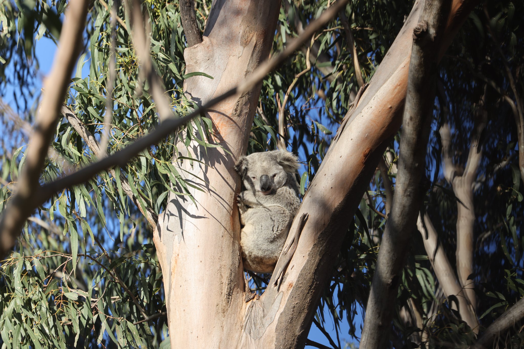
Campbelltown Koala. Photo courtesy P Durman, taken August 2022