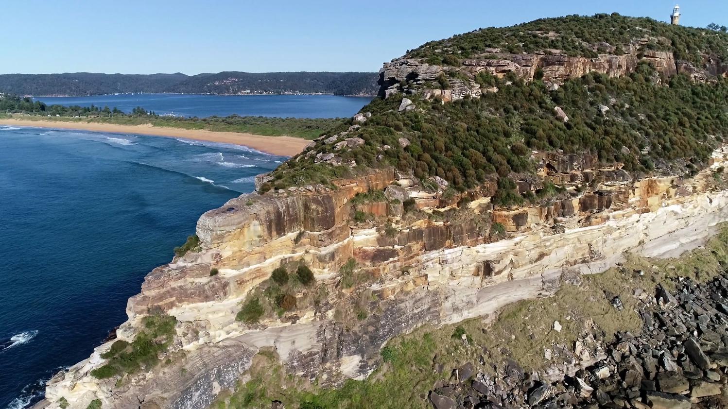
This video begins in Cabbage Tree Bay at the south end of the Palm Beach isthmus and flies north to Barrenjoey where the lighthouse stands at 102m ASL. The upper half to three quarters of that headland is composed of Hawkesbury Sandstone overlying Upper Newport Formation, and one of Sydney’s larger dykes outcrops at sea level on the northern edge.
Barrenjoey is generally referred to as a tied island or tombolo, one of those slightly annoying terms beloved of geographers that does not always tell us much about the feature. The general meaning of tombolo is an island linked to the mainland shore by a body of sediment that is usually assumed to have accumulated as a spit.
The Pittwater-Barrenjoey link is a tied island in the simplest sense but the story is considerably more complex than the term tombolo suggests. The word is Italian, and although widely used in English, in the original language it more often refers to things to do with crochet or bobbin lace. You do sometimes wonder about translations.
None of the tied islands near Sydney; Kurnell, North Head, Long Reef, and Barrenjoey, are linked to the mainland by spits, they are all connected by barrier beach systems. Palm Beach is a good example and to understand its formation we need to look at bedrock morphology and sediment distribution beneath the waves.
The present day entrance to Pittwater is across a drowned bedrock ridge with a water depth of only 12m between Barrenjoey and West Head.
Seismic profiles reveal the presence of two deep river channels eroded into bedrock and partly filled with sediment. One is the ancient channel of the Hawkesbury River that passes between Barrenjoey and Lion Island at a depth of >100m. The other is the former channel of the ‘Pittwater River’ or McCarrs Creek that runs the length of Pittwater then passes under the sand barrier south of Barrenjoey at a depth of 76m.
The two palaeochannels join about 4km offshore at 120m depth, on what was the coastline at the peak of the last ice age about 20,000 years ago.
As the global ice sheets melted, sea level rose rapidly, sweeping sand onto the retreating coast. A beach/dune barrier system formed the isthmus but would have been kept open at the northern end by the Pittwater River until sea level reached the crest of the ridge between Barrenjoey and West Head. At that time the route of the Pittwater River would have shifted to flow north and join the Hawkesbury allowing the sand barrier to close. The distribution of tidal sand and estuarine mud in both Broken Bay and Pittwater, and the presence of deep water (>40m) in the upper reaches of Pittwater confirm the story. Additionally, a number of radiocarbon dates have been obtained from different sediments, almost all of which fall within the Holocene (<12,000 years) showing that these changes took place well within the time frame of human occupation.
Aboriginal people lived in this landscape when Pittwater and the Hawkesbury were deep valleys probably carrying spotted gum forest and pockets of rainforest. Barrenjoey was a lesser peak on a stony ridge extending from Commodore Heights and ending some 4 km east of the present shore. Those people would have observed the sea level rise, saw regular turbulent tidal flows in and out of Pittwater at the foot of Barrenjoey, and the shift of the Pittwater River into the Hawkesbury as the ridge was drowned. This was a bold landscape that must have had important stories attached to it, all of which have been lost.
Particular scenes:
0.23-0.53 Leaving the bedrock headland behind we fly north along the sand barrier toward Barrenjoey with a view across Pittwater to West Head. Dunes rise onto the south side of Barrenjoey and today almost all of the sand is covered in vegetation.
This was not the case for most of the 20th Century. Photographs from 1912 show that native plants were still intact except for a patch of active dunes at the north end, but by 1927 half of the original plant cover had gone. In the 1940s a golf course and a camping ground were established and by 1947 there was almost no natural vegetation left on the sand.
In 1974 storms waves broke across the barrier and that event triggered a huge conservation effort to stabilise beaches and dunes all along the coast. The foredune was reshaped destroying a large number of Aboriginal shell middens and using a poor selection of plant species, some of which have subsequently become environmental weeds.
0.54-1.30 Below the lighthouse the southeast face of Barrenjoey reveals two main bands of sandstone. The upper unit is certainly Hawkesbury Sandstone. A quartz sandstone deposited in a major river with its headwaters somewhere in ‘southern’ Gondwana in what is now Antarctica. Some of the lower bands of sandstones are part of the upper Newport Formation but on this exposure it is a challenge to decide where to draw the line.
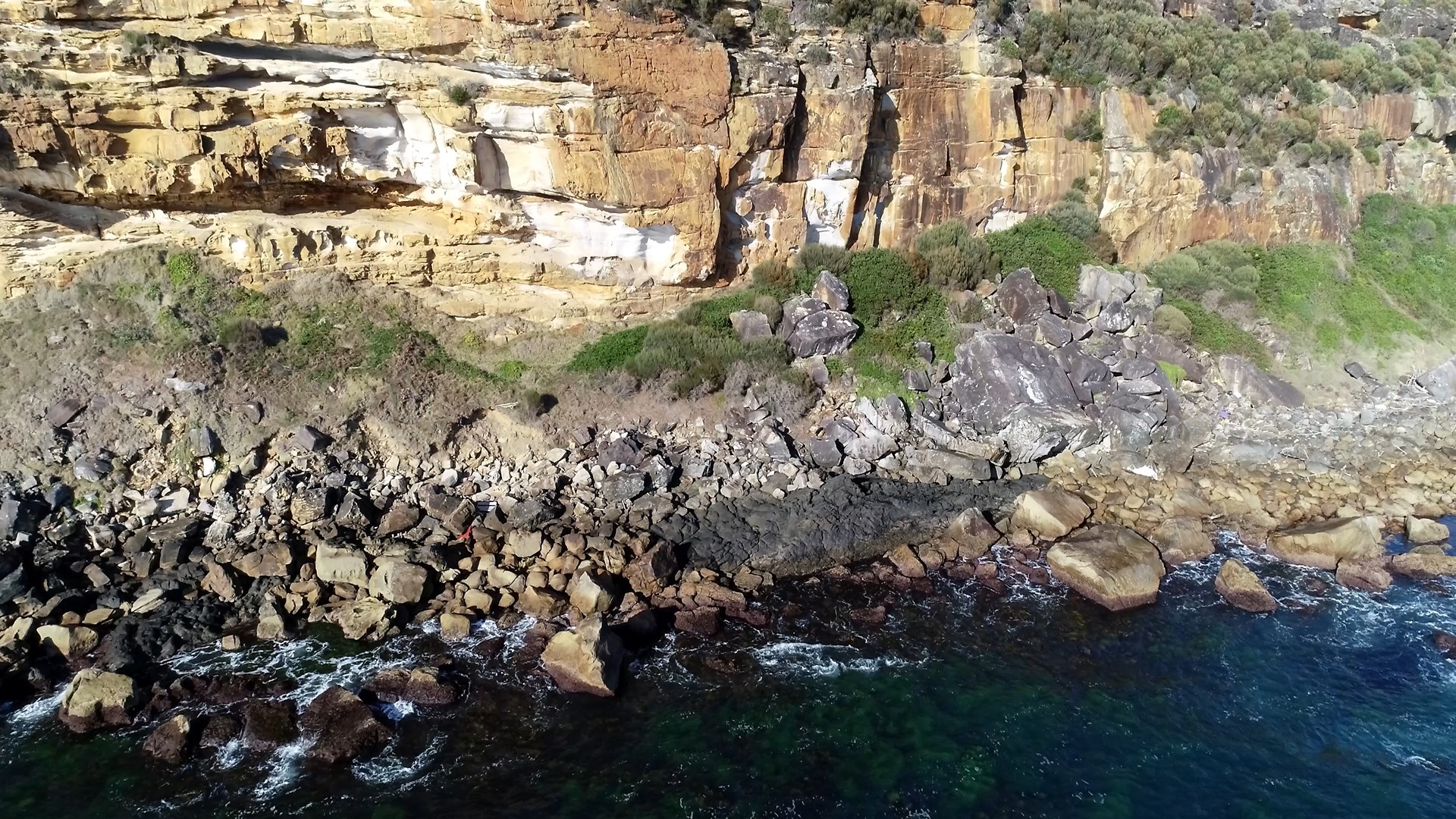
2.18 The uppermost sandstone (Hawkesbury) can now be seen to break up as much larger joint blocks several of which are slowly gliding to the slope edge and a few of which are amongst the boulders at the base of the cliff.
2.33 The eastern point of Barrenjoey has six benches formed on the sandstone beds and there is a very large single block (circa 600 tonnes) lying at an angle on the lowest part of the southern face. This appears to have slid out of a corner of the narrow ridge half way up the cliff. Just below that position the beds show an angular disconformity which is perhaps the best place to identify as the Newport/Hawkesbury contact. This position is consistent with stratigraphic work by Cowan but is a lot lower on the cliff than indicated by the Sydney geological map. This conclusion needs to be tested by fieldwork.
3.25-3.53 As at Long Reef the most extensive shore platform, or more accurately almost the only shore platform, on Barrenjoey occurs at the eastern tip where waves can approach from south, east, and north.
3.57-4.20 On the north face there is more rock exposure and the predicted Newport/Hawkesbury contact seems to be confirmed at the base of the orange brown stained sandstone. The underlying Newport lithic sandstones and laminates weather more rapidly and are recessive cliff faces.
4.20-4.50 Rounded shrubs on the upper bench with an orange brown colour are female Allocasuarina distyla (shrubby she-oak) which has a limited distribution on the central coast and is tolerant of salt spray. The lowest slope is a Themeda australis grassland growing in scree. This species also likes sea cliffs and headlands and is an endangered ecological community.
5.25-5.31 Brown vertical stains on the lower cliff are caused by deposits of iron oxide carried by soil water and precipitated when the water reaches the atmosphere as it seeps out of the bench and onto the cliff.
5.45-5.48 Sandstone beds within the shallow overhang are contorted as a result of slumping and folding of saturated sediment when they were deposited. Heavy black staining on the sandstone is blue-green algae.
7.50 The same staining creates a dark line on the boulders just above the breaking waves on this aspect of the headland, also visible at 8.57. At about the same point there is a marked colour shift in the vegetation on the scree where the dull grey green of the Themeda changes to something else.
7.57-8.01 At sea level and just to the left of the lighthouse a short section without boulders is occupied by a dark grey rock. This the first point where the Barrenjoey dyke can be seen.
The Barrenjoey dyke is probably Sydney’s largest. It trends west for at least 16km, is perhaps 9-12m wide, composed of dolerite, and has been dated to the middle Jurassic between 171 and 173 million years ago. These properties are similar to those of the ‘Great Sydney Dyke’ which extends from Glebe Island Container Terminal 10km offshore from Waverley Cemetery. The Great Sydney Dyke has caused numerous engineering headaches and the only differences with Barrenjoey is that it is about 10 million years younger and much better studied. Perhaps we have been a bit hasty labelling one as ‘Great’ without having paid much attention to any other.
The dyke exposed here (black) stretches across Pittwater from Barrenjoey into West Head and beyond
The origin of Sydney’s dykes have often been suggested as a consequence of the opening of the Tasman Sea 84 million years ago. But for these particular dykes their orientation is wrong and they are too old, therefore their structural origin remains a mystery.
9.57- 10.20 Dyke outcrop.
12.19-12.31 Dyke again with clear vertical jointing indicating that it dips at 90 degrees. The edges are not visible here but the dyke is at least 7m wide and will have a contact metamorphic zone on either wall. Finding fresh rocks in local dykes is unusual, was this place a source for Aboriginal edge ground axes?
12.42 Weathered dolerite in the dyke.
13.17-13.54 Moving around into Pittwater a strong water seepage or spring is found and joint spacing on the shore platform is much closer – probably on or close to the dyke margin.
14.05-14.10 Looking back across the isthmus it is hard to believe that there is a river channel 76m below the sand. A marked difference in beach width and gradient between Palm Beach (left) and Barrenjoey beach is also apparent.
14.18-14.48 Another length of sheared jointing linked to the dyke and perhaps a fault line. On this alignment the dyke can be projected across to West Head.
14.50-17.17 The seals in this recently established colony are completely unaware of the geological significance of their basking site.
17.24 Remains of the WWII West Head Battery and its haulway are very close to the location of the dyke under the West Head Lookout.
Dr Peter Mitchell OAM