Environment News: August 2026 - Issue 657

Week One August 2026: Issue 657 (published Sunday August 2)

NSW code Labelling native species 'invasive' responsible for loss of 3.2 million hectares of bushland 

A new report, released July 30 2026, from Nature Conservation Council NSW (NCC) has revealed that more than three million hectares of bushland across the state is at risk of clearing because of a misleading classification that labels iconic Australian species, like the coolabah tree, as invasive. 

This follows last week's news that despite the Minns government promise to rein in excessive land clearing in NSW, rates jumped by 16% in its first full year in power.  

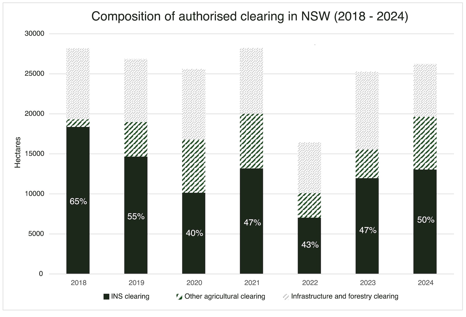
The NCC report looks at the so-called “Invasive Native Species” (INS) provision, and confirms that not only did it represent half of all authorised native vegetation clearing in NSW between 2018 and 2024, it’s a classification with no scientific basis.  

NCC, the state’s peak environmental advocacy organisation, is calling on the NSW Government to make good on its three-year-old election promise and get habitat clearing rates under control.  

The first step to turn this around the NCC states is to remove the INS code. 

NCC Conservation Officer, Candice Bartlett said: 

“The rate at which habitat is being destroyed in NSW is shocking, but unsurprising considering the government has done nothing to strengthen its protection laws. 

“The clearing of native vegetation under ‘INS’ provisions is the single greatest contributor to habitat destruction in NSW, and so we’ve taken a closer look at the label. 

“We found ‘INS’ is a case of mistaken identity. In this instance the word ‘invasive’ is not referring to weeds but rather valuable native habitat like wattles, eucalypts, and even the coolabah tree made famous by the jolly swagman. 

“The term ‘invasive’ makes these species sound harmful, like pests. This label is being used inappropriately as a blanket term for native species occurring in their natural range that provide habitat for native wildlife.  

“The scale of habitat clearing caused by this irresponsible label is hard to comprehend. An area six times the size of Royal National Park was cleared under “INS” provisions between 2018 to 2024. 

“What’s worse is 'INS’ is a political construct, unique to NSW, with no scientific basis. If you search for it in a library or research database, it will return zero relevant hits.

“Habitat clearing is one of the biggest drivers of biodiversity loss in NSW and this report exposes what is behind broadscale land clearing. The ‘INS’ provisions are the cause of large-scale habitat destruction where threatened species live, like the pink cockatoo and south-eastern hooded robin. 

“The government’s own scientists predict NSW will lose almost 500 wildlife species to extinction within the next century. The time for action is now. 

“The first step to get habitat clearing under control is to remove the invasive native species loophole.” 

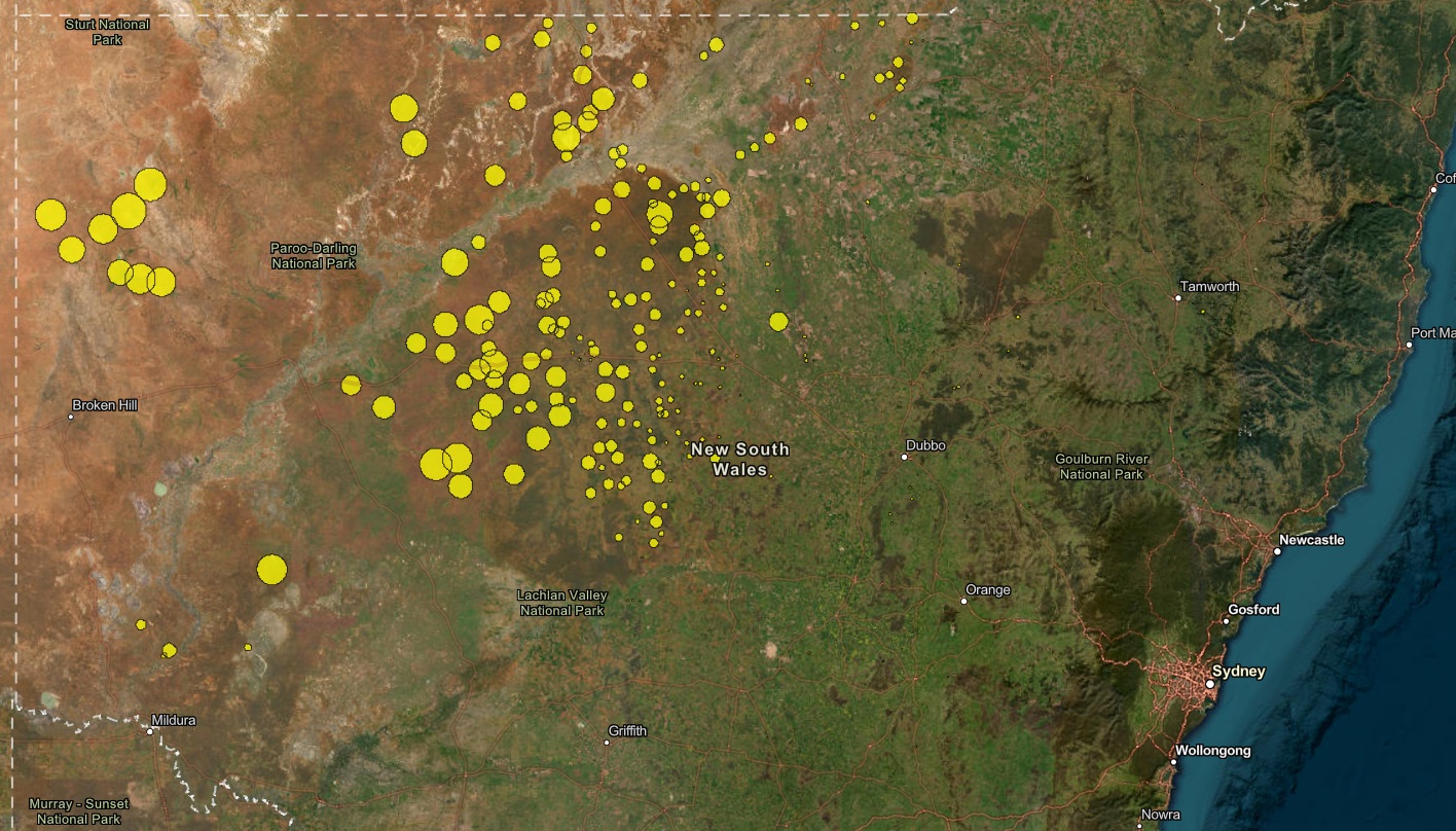
The Nature Conservation Council report found approvals for land clearing are concentrated in north-west NSW.  Graphic Supplied: Nature Conservation Council.

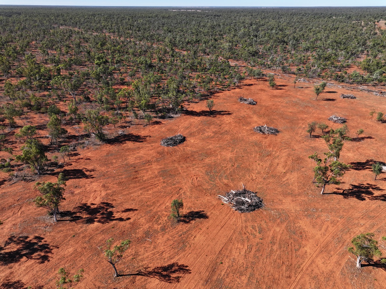
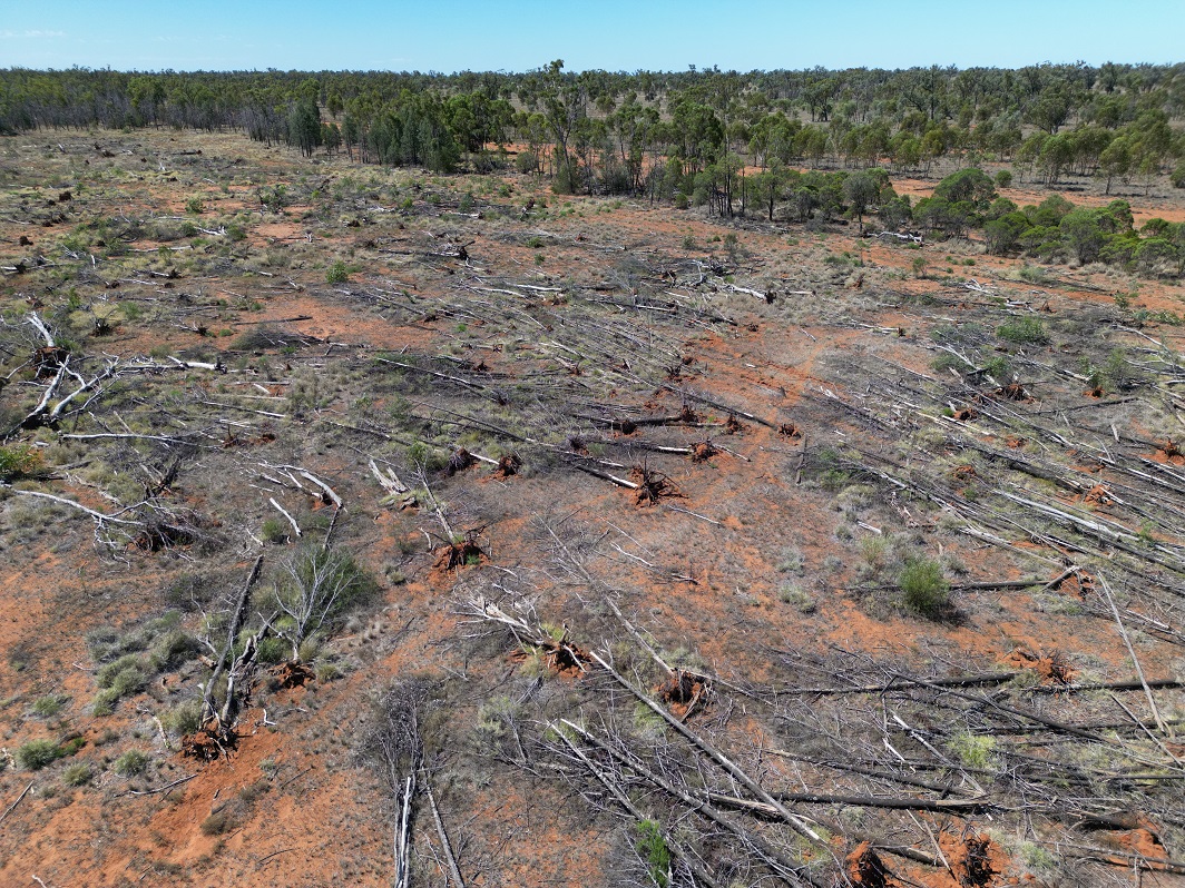
Land clearing in western NSW. Photo Supplied: Nature Conservation Council.

NCC is calling for urgent change to protect what’s left. 

“The Minns Government committed to stop excessive land clearing. To do so, it must remove the INS code as immediate priority, and then continue to put nature first, otherwise we will have no trees left to clear,” Bartlett said. 

Removing the INS code would help reduce high-risk clearing, but landowners would be able to continue to clear land and thin vegetation under other lower-risk codes and would have no impact on routine land management activities.''

The Australian Association of Bush Regenerators' Peter Dixon said:

“NSW’s inappropriate ‘INS’ label overlooks the true conservation value landscapes provide. 

“When managed properly through bush regeneration principles, natural regeneration currently considered ‘invasive’ can become some of our most valuable conservation assets.  

“These areas reveal where ecosystems retain resilience, where native seedbanks remain intact, and where restoration can be achieved most efficiently.  

“Rather than recognising these areas as important sources of biodiversity, habitat and connectivity, NSW’s current clearing laws often facilitate their removal and the ‘INS’ label must go.” 

According to the report, ''NSW's INS Label: How a misleading classification is driving broadscale clearing in NSW'' PDF: 3.3MB), the 3.2 million hectares approved for clearing includes 2.3 million hectares covered by legacy permits valid until the early 2030s. These were issued under the Native Vegetation Act 2003, which was repealed in 2017.

Another 922,000 hectares of clearing was approved since 2018 under the current Land Management Code. 

The report found at least 171 threatened plant and animal species have been recorded within these INS habitats.

Supplied: Nature Conservation Council.

NSW Farmers Association viewpoint

The NSW Farmers Association has strongly defended the Invasive Native Species (INS) land clearing code, stating that it is a vital, practical tool for farm management rather than a driver of environmental destruction.

The association noted that headline figures—such as reports showing over 3.2 million hectares under permits—do not reflect actual clearing done or planned, as an approval over an area does not equal total clearing.

In an interview with ABC News Bronwyn Petrie, conservation and resource management committee chair, said removing the INS code would have "dire consequences".

Ms Petrie disputed that a plant growing in its natural range should not be deemed "invasive", citing a property near Tenterfield with native cypress pine trees as an "environmental desert".

"You can hardly walk between the trees. There's nothing on the ground whatsoever, just bare dirt," she toldf the ABC.

"Our birdlife is suffering as a result. Our macropods are suffering because there's no grasses for them to eat."

Ms Petrie said within six months of a CSIRO trial plot that cleared some of these trees, there was a "massive increase" in ground cover, which supported more biodiversity and improved long-term land management.

However, University of New South Wales environmental scientist David Eldridge, who spent the first decade of his career working for the state government in western NSW, supporting graziers and pastoralists as they removed native woody plants now listed as INS, now finds further scientific research had changed his mind.

"A lot of this was driven not by science but by the needs of [land] managers … with strong input from pastoralists or graziers that wanted to get rid of these plants," he told the ABC

"The term 'invasive native species' is meant to conjure up images of a threatening, nasty wasteland that we need to somehow improve … but in fact, it's become a backdoor method for broadscale clearing, as far as I'm concerned."

The NCC report states more than 3.2 million hectares of native vegetation mapped as “INS” remains at risk of clearing under active approvals in NSW, under legacy provisions and current legislation.

The current NSW “INS” framework enables the broadscale clearing of native vegetation, including mature native vegetation, regenerating habitat, and threatened ecological communities.  

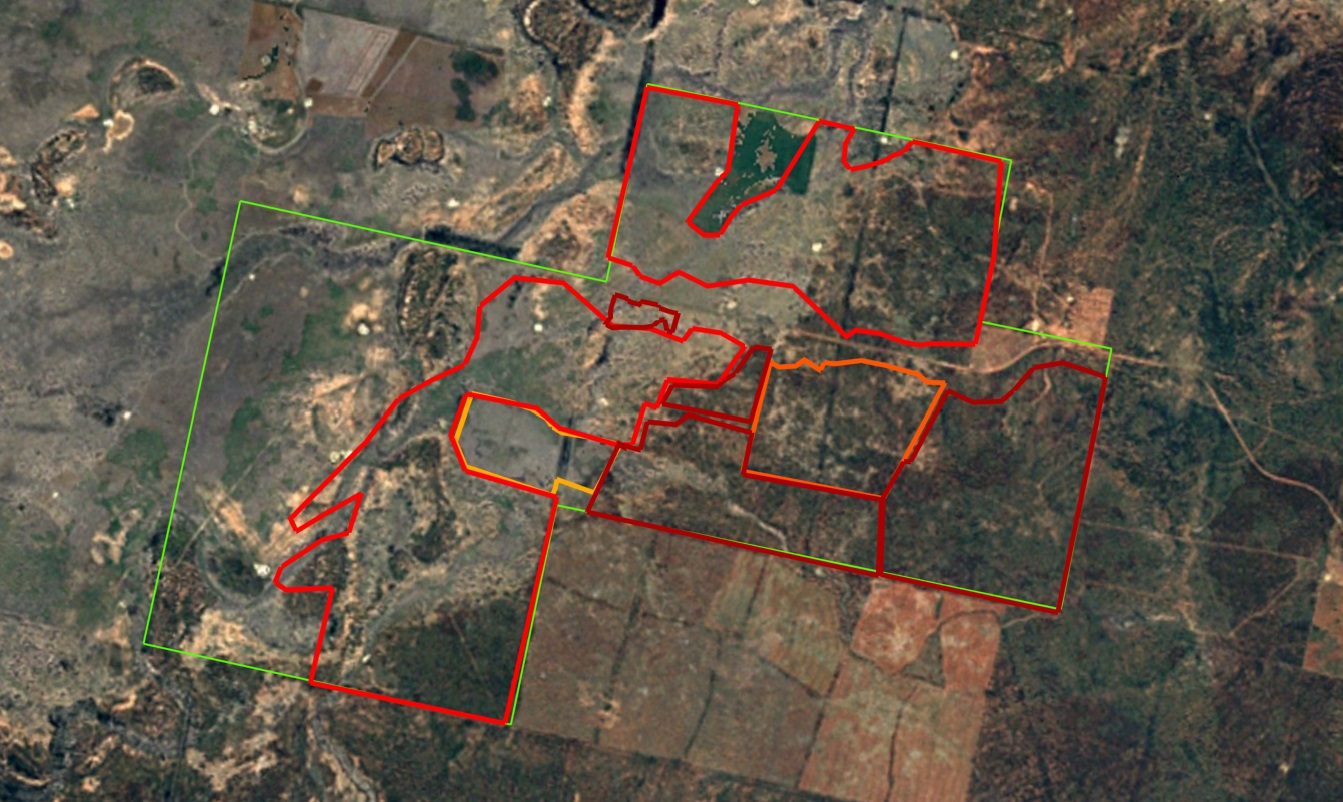
Before - Collarenebri 1985. Image Supplied: Nature Conservation Council.

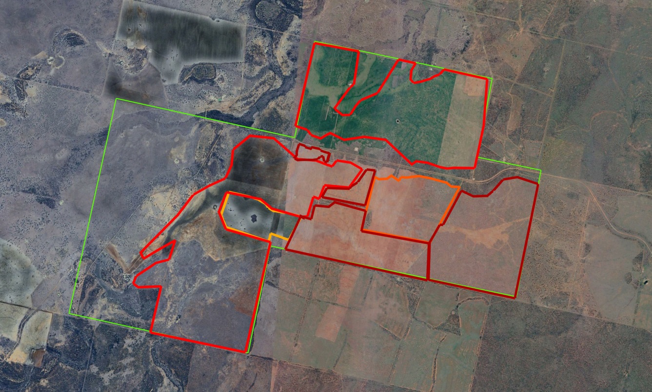
After - Collarenebri 2025. Image Supplied: Nature Conservation Council

Background: 

Since 1788, more than 60% of the state’s original native vegetation has been cleared, thinned or significantly disturbed, with many lost altogether. 

Between 2018 and 2024 more than 88,000 hectares of native vegetation were cleared in NSW under “invasive native species” provisions on rural regulated land. This represents 50% of all authorised native vegetation clearing across the state (or 73% of authorised clearing specifically attributed to the agricultural sector).  

Clearing of native plants, and the destruction of habitat associated with it, is recognised as one of the greatest threats to biodiversity in NSW. 

At least 171 threatened plant and animal species have been recorded in “INS” associated habitats in Western and Central West NSW alone. This list includes 81 species listed as endangered or critically endangered in NSW that are reliant on native vegetation that occurs on the “INS” list as primary habitat. 

Part 2 Division 2 of the Land Management (Native Vegetation) Code 2018 permits extensive clearing where listed so-called “INS” species occur, allowing up to 90% of each 1000 hectare area to be cleared. 

In some areas disturbances – such as changes in fire management, livestock grazing, climate and historical clearing – have created conditions where some native trees and shrubs regenerate densely. Increased abundance of native vegetation does not make these species invasive, nor does it remove their ecological value, the NCC states.  

 Native woodland clearing in western NSW. Photo Supplied: Nature Conservation Council.

How retirees, beachcombers and communities help scientists track everything from threatened species to algal blooms

Katie Irvine, Adelaide University and Ben Sparrow, Adelaide University

How healthy are Australia’s ecosystems? To answer that, scientists need data. But Australia is huge – and the number of professional scientists is limited. That’s where citizen science can help.

Every winter, thousands of grey nomads take to the roads and head north. Families return to familiar campgrounds for school holidays. Bushwalkers move through forests and along coastlines. School students catch invertebrates in rivers to learn about waterway health.

Each of these groups – and many more – can collect data vital to conservation efforts. When a citizen scientist uploads a photo of a flower, frog or animal to a central repository such as iNaturalist and eBird, anyone can see it and the location, date and time it was observed.

Citizen science – public participation and collaboration in scientific research – is coming of age. Increasingly, professional scientists are partnering with citizen scientists – and making requests.

Australia faces rapid biodiversity loss, shifting species distributions and widespread ecological change. To respond, scientists and authorities need long-term, standardised monitoring. Professional scientists cannot achieve this alone. No wonder former Chief Scientist Ian Chubb called for grey nomads and others to lend a hand.

No longer a novelty

Old debates over the accuracy and reliability of the data are being drowned out by mounting evidence showing citizen scientists are providing high-quality information.

One of the most valuable things citizen scientists can do is make repeated observations of specific species at specific locations to complement national-scale monitoring. The best data comes from monitoring one location over time using consistent methods and posting data to public databases.

Here are three examples where professional and citizen scientists are working together.

Spotting rare orchids

More than 1,800 species of orchid grow in Australia – and many are found only here.

These remarkable flowering plants make up about 10% of the country’s plant species. Many are threatened by expansion of farming and urban areas.

One challenge for scientists is to understand where species are growing and correctly classify them. Many native orchid species look similar. If a rare species is classified as a common one, it could put the rare species at risk.

This is where initiatives such as Wild Orchid Watch come in.

When citizen scientists spot an orchid, they take photos and record details of when and where it was sighted. Orchid observations are repeated over time and species identifications are verified by ecologists in the iNaturalist platform. Citizen scientists also collect data on orchid numbers and time of flowering.

For regular orchid-spotter Adrian Uren, the process is rewarding. As he has written:

The challenge of finding these little jewels in the bush definitely appeals to me and it’s very rewarding when I find a new species or a spectacular patch of them.

close up of orchid resembling a duck in flight.
Australia is rich in orchid species, such as the unmistakable large flying duck orchid (Caleana major). Reiner/iNaturalist, CC BY-NC-ND

Tracking threatened species

TERN Australia is the national ecosystem observatory. Scientists record changes to land ecosystems over time using field monitoring across 16 intensively monitored sites and more than 1,000 1-hectare plots around the country.

Despite these monitoring efforts, there are gaps in the data – both in place and time. Citizen scientists are helping fill these gaps by providing data from places, times and local scales not feasible for scientists to reach.

The Threatened Species Index commenced in 2016 as a way to track the abundance of Australia’s species in trouble. It relies heavily on thousands of citizen scientists, who collect species data consistently.

Without their work, we wouldn’t know threatened species populations have fallen almost 60% since 2000 – or that there are recent signs of improvement for some groups, though more long-term data is needed to confirm recovery. The Australian government now uses data from the index to evaluate conservation initiatives and report biodiversity trends.

Tracking the algal bloom

In March 2025, thousands of sea creatures started washing up dead on South Australian beaches. Underwater footage showed swathes of dead and dying marine life. The culprit turned out to be a mix of tiny, dangerous Karenia algae species. The bloom hasn’t completely disappeared, and has killed millions of marine animals.

As the devastation unfolded, citizen scientists responded by posting data and images of affected species to iNaturalist and responding to requests for help from scientists and organisations such as OzFish. The result was a living repository of data helping track the spread.

dead seadragons arranged on a beach.
Large numbers of marine animals such as these weedy seadragons washed up dead during South Australia’s algal bloom. scotthedges/iNaturalist, CC BY-NC-ND

Calling for reinforcements

Scientists, authorities and regulators are requesting more and more support from the public.

Increasingly, we’re seeing requests for data on specific plants, animals and fungi. There are broader requests too, such as data on ecosystems or environmental disasters, from hard-to-reach locations or during critical seasonal windows.

Examples include: FrogWatch SA, Fungi for Function, Waterwatch Victoria, Waterwatch ACT, Ocean Connect, MangroveWatch, Coastsnap, eBird and Where? Where? Wedgie!.

For some citizen scientists, a big drawcard is being able to interact with experts to identify species. Projects co-designed by professional and citizen scientists are likely to become more popular.

There’s more work to be done to link popular citizen science apps with national databases such as the Atlas of Living Australia and TERN’s Data Discovery Portal – and ensuring data is recorded in useful ways.

The more citizen scientists, the better. When enough interested people get outdoors with a smartphone, they can collect vital data and help authorities respond to environmental changes.The Conversation

Katie Irvine, TERN Surveillance Communication Lead, Adelaide University and Ben Sparrow, Associate Professor and Director - TERN Ecosystem Surveillance, Adelaide University

This article is republished from The Conversation under a Creative Commons license. Read the original article.

More than half of Earth’s migratory bird species are declining – here’s how we can still save them

A bird with unique spoon-shaped bill stands in water on the sand.
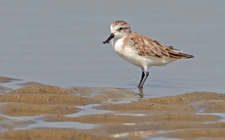
The spoon-billed sandpiper, a small wading bird, flies nearly 5,000 miles (8,000 km) on its annual migration. Tareq's Photography/Wikimedia, CC BY-SA
Peter P. Marra, Georgetown University and Nathan W. Cooper, Smithsonian Institution

Every year, billions of migratory birds connect the world’s continents, oceans and ecosystems as they undertake epic journeys between their foraging habitats and their breeding grounds.

A bobolink (Dolichonyx oryzivorus) leaves its breeding grasslands of North America for the Pampas of South America. A Newell’s shearwater (Puffinus newelli) spends months soaring across the North Pacific before returning to the Hawaiian Islands to breed. A spoon-billed sandpiper (Calidris pygmaea) travels from Arctic Russia to the rapidly disappearing tidal mudflats of Southeast Asia for its nonbreeding season.

These birds could hardly be more different. They occupy different habitats, follow different migratory routes and face different threats. Yet they share one remarkable characteristic: Their survival depends on networks of habitats stretching across thousands of miles and multiple countries.

a black  bird with a yellow cap on its head and white patch on its wing.
The bobolink breeds in the grasslands of North America, but it makes an epic migration journey to South America each year. Grayson Smith/USFWS.

Today, all three species and many others are in trouble. Their migrations remain among nature’s greatest spectacles, but the birds themselves are increasingly at risk as the habitats and ecological connections they depend upon are lost or degraded and threats to their survival and ability to reproduce increase.

We study migratory birds as scientists. With an international group of colleagues, we just published a comprehensive assessment of the status, threats and conservation efforts involving more than 3,380 of Earth’s migratory bird species.

The results are sobering. We found that more than half of the world’s migratory bird species are declining because of an array of threats, including habitat loss, invasive species that harm birds, collisions with buildings, hunting, the pet trade, toxic pesticides and, in some cases, being caught in commercial fishing nets.

But our study offers a second conclusion with more hope. The science around migratory birds has changed dramatically over the past two decades, and conservation can help save these incredible species – if governments act before they become endangered.

Protecting birds across their epic journeys

If migratory bird conservation is refocused on the birds’ full annual cycles, it can protect birds and their habitats throughout the year, from their breeding grounds to their nonbreeding homes and their migratory routes in between.

This approach combines protecting and restoring important places, reducing threats wherever they occur. It also relies on international cooperation and proactive conservation led by engaged governments before species become endangered.

Maps show different migration patterns.
Some of the amazing migrations that take place around the world. (a) The lines reflect prebreeding (solid) and postbreeding (dashed) migration routes of several birds. (b) Some birds, like the Hudsonian godwit (Limosa haemastica), a member of the sandpiper family whose annual cycle is shown here, travel thousands of miles. (c) The Barau’s petrel (Pterodroma baraui) spends much of its nonbreeding time over islands and open water. (d) Other species, like the giant hummingbird (P. gigas) found in the Andes mountains, travel to higher elevations after breeding. Nature Reviews Biodiversity/Peter P. Marra, et al., 2026

Migratory birds are far more than remarkable travelers. They pollinate plants, disperse seeds, control agricultural pests, transport nutrients between ecosystems and support local economies by drawing birdwatchers and ecotourism. Their declines are not simply a loss of biodiversity; they signal a growing breakdown in ecosystems that sustain both wildlife and people.

The encouraging news is that humans have never been better equipped to reverse these species’ declines.

Hands attached a tiny backpack to a bird.
Researchers attach a satellite transmitter to the back of a red knot, a rapidly declining migratory species. Tiny trackers like these show migration routes and help locate the potential harms and ways to help these species. Tim Romano, courtesy of the Smithsonian Institution
A penny compared to a tiny tracker that's not much later than the letter O in 'One Cent'
Trackers on birds are like tiny backpacks. Smaller than a penny, birds can carry them hundreds of miles, giving scientists insight into their patterns and habitats and ways to help them survive. Tim Romano, courtesy of the Smithsonian Institution

Miniature tracking devices, genetics, automated radio telemetry networks, long-term monitoring and citizen-science initiatives such as eBird that document species numbers around the world have transformed knowledge of migratory birds’ habits and the risks they face.

For the first time, scientists can follow individual birds across continents and determine where conservation actions will have the greatest impact.

A new strategy

For much of the past century, migratory bird conservation focused on protecting important places, such as the breeding grounds, wetlands, nonbreeding habitats and migration stopover sites birds depend upon.

That strategy has been enormously successful and remains indispensable. Protected areas have prevented countless extinctions and will continue to be a cornerstone of biodiversity conservation.

A hand and bird flying away
A scientist releases a Kirtland’s warbler with its tracker attached. Tim Romano, courtesy of the Smithsonian Institution

But research has revealed something equally important: Protecting places, while essential, is often not enough to conserve species whose lives unfold across continents and oceans. It’s also important to understand where and when populations are most at risk and address those constraints across the birds’ entire annual cycle.

The three species that opened this story illustrate why.

Bobolinks breed across North American grasslands but spend much of the year in South America. Conserving breeding habitat alone cannot reverse their declines if grasslands continue to disappear or if birds are poisoned by pesticides.

Newell’s shearwaters spend most of their lives over the Pacific Ocean but return to Hawaii to breed, where artificial lights, collisions with power lines, and introduced predators such as domestic cats threaten already vulnerable populations.

Listen to spoon-billed sandpipers as they forage for food. Cornell Bird Lab.

Critically endangered spoon-billed sandpipers depend on a shrinking network of tidal mudflats that serve as stopover sites between their breeding grounds on Russia’s Chukotka Peninsula and their nonbreeding areas in Southeast Asia. Losing even a handful of these staging areas can jeopardize one of the world’s rarest migratory birds.

Each species requires a different conservation strategy, but all require the same way of thinking: conserving their entire annual cycle rather than focusing on a single place, season or threat.

Fortunately, this approach is already starting to take hold in the United States and demonstrates what is possible.

What success can look like

Road to Recovery is an international initiative designed to reverse the losses of North America’s fastest-declining bird species before they require protection under U.S. endangered species legislation.

Rather than waiting for populations to collapse, Road to Recovery brings together scientists, governments, conservation organizations, landowners and local communities to form species working groups. These groups help identify the harms bird populations are facing and how to be more surgical in where limited conservation dollars are invested.

Today, more than 50 international working groups are developing conservation strategies for species including bobolinks and lesser yellowlegs (Tringa flavipes) to evening grosbeaks (Coccothraustes vespertinus) and yellow-billed cuckoos (Coccyzus americanus). Their work has already led to new research, habitat protection, policy changes, hunting reforms and international partnerships.

International agreements such as the Convention on the Conservation of Migratory Species of Wild Animals, along with regional flyway partnerships and treaties, provide ways for nations to work together to conserve migratory species across political boundaries.

Scientists attach a leg band with a tracker to a very calm Newell’s shearwater during its breeding season in Hawaii.

However, the convention’s effectiveness is severely hindered when many of the world’s largest, wealthiest and most influential countries have not signed on to it. That includes the United States, Canada, Mexico, Russia and Japan.

Broader international participation and sustained investment from governments can help translate scientific knowledge into coordinated conservation action across the full annual cycle.

But governments cannot do it alone. Landowners, businesses, conservation organizations and individuals all have roles to play. They can help protect and restore habitat and reduce threats, such as free-ranging cats and collisions with buildings. They can support bird-friendly policies and participate in citizen-science programs that help track migratory bird populations.

Applying these lessons

There is every reason for hope.

Around the world, conservation initiatives repeatedly demonstrate that when threats are identified and addressed, bird populations recover. The pesticide DDT almost caused the extinction of species such as the bald eagle, peregrine falcon and osprey, but humans stepped in, banned its use, and all species recovered.

The challenge now is applying what science has found.

Next spring, bobolinks will once again return to North America’s grasslands. Newell’s shearwaters will navigate thousands of miles of open ocean back to Hawaii. Spoon-billed sandpipers will once again attempt one of the world’s most extraordinary migrations.

Whether future generations can continue to see these magnificent migrations will depend on the choices of current generations and the steps they take to save them.The Conversation

Peter P. Marra, Dean of The Earth Commons, Professor of Biology and the Environment, Georgetown University and Nathan W. Cooper, Research Ecologist, Smithsonian Institution

This article is republished from The Conversation under a Creative Commons license. Read the original article.

NB: Listings Changes for local Migratory Birds on July 25, 2025: 6 new species Now Critically Endangered or Vulnerable to Extinction -an orchid + the grey plover, black-tailed godwit, ruddy turnstone, sharp-tailed sandpiper, red knot 


NSW Threatened Species Scientific Committee final determination for the black-tailed godwit Limosa limosa

The black-tailed godwit Limosa limosa has been listed as an endangered species.

The black-tailed godwit is a migratory species. During the austral summer non-breeding season, black-tailed godwits are found in all states and territories of Australia. The species was widespread around Australian coastlines and occasionally occurs inland.

The black-tailed godwit Limosa limosa (Linnaeus, 1758) was found to be Endangered with Extinction in accordance with the following provisions in the Biodiversity Conservation Regulation 2017: Clause 4.2(1 b)(2 b) because: (1) the species has undergone a severe reduction in population size of 52–77.5% over a three-generation timespan.

Black-tailed godwits are primarily a coastal species. They are usually found in sheltered bays, estuaries, and lagoons with large intertidal mudflats and/or sandflats. Wetland loss and degradation, and the subsequent loss of feeding and roosting habitat for the black-tailed godwit in Australia has occurred mainly due to competing land uses and ignorance of the values of wetlands. Due to the distribution of the human population, estuaries and permanent wetlands of the coastal lowlands have experienced most losses due to development.

Additional threats include clearing areas of saltmarsh for solar salt production; damage to wetland areas by rubbish dumping, storm water draining, as well as run-off from urban areas, which alters the natural salinity regime of wetland areas (Geoscience Australia 2021). The increasing requirement for residential housing and urban and coastal infrastructure is also causing the draining and filling of wetlands throughout the EAAF, affecting the black-tailed godwit’s ability to rest and feed en route to breeding and non-breeding areas. 

Freshwater Wetlands on Coastal Floodplains of the New South Wales North Coast, Sydney Basin and South East Corner Bioregions, which provides important habitat for the black-tailed godwit in NSW, is listed as an Endangered Ecological Community in NSW. 

The population decline of the black-tailed godwit is also thought to be due to changes to the species’ coastal stopover locations within the EAAF, particularly along the coast of the Yellow Sea. Rapid development for aquaculture, industry, and rapidly increasing human populations are a major driver of these changes. The degradation and loss of stopover locations is amplified by the invasion of cordgrass  (Spartina alterniflora) and by excessive domestic, industrial, and aquaculture discharges.

The main threat to this species in NSW and Australia is habitat loss and disturbance at feeding and roosting sites, particularly disturbances from human recreation and off-leash dogs. 

More information on the species can be found in the Committees' reasons for final determination: Limosa limosa

Black-tailed godwit (Limosa limosa) flock. Image Credit: Wayne Reynolds/DCCEEW

NSW Threatened Species Scientific Committee final determination for the ruddy turnstone Arenaria interpres

The ruddy turnstone Arenaria interpres has been listed as a vulnerable to extinction species.

The ruddy turnstone is a migratory shorebird that was widespread within Australia during the austral summer non-breeding season, occurring around coastlines and occasionally inland.

The main reason for this species being eligible for listing in the Vulnerable category is the moderate population reduction estimated at 26-72% that has occurred over three generations, and the causes of the decline are not fully understood. This species is assessed only on the basis of its extinction risk in Australia because that scale is appropriate to the biology of the taxon due to its annual migratory movements into, and within Australia. 

The ruddy turnstone is widespread within Australia during the austral summer non-breeding season (Bamford et al. 2008), occurring around coastlines and occasionally inland.

In Australia including in New South Wales (NSW), ruddy turnstones typically roost along platforms and shelves of rock, shingle, or gravel beaches, often with shallow tidal pools nearby - Long Reef for example. They strongly prefer rocky shores or beaches where there are large deposits of rotting seaweed. 

Feeding takes place over the whole tidal range, however, most populations of the ruddy turnstone will likely spend disproportionate amounts of time foraging on the upper tidal flats (Wu and Wilcove 2020). Ruddy turnstones are  carnivorous, feeding primarily on insects, worms, crustaceans, molluscs, and spiders (Higgins and Davies 1996). Feeding is both diurnal and nocturnal. They  have also been occasionally recorded feeding on eggs and carrion. During the non-breeding season, their main or only food source is maggots obtained from rotting  seaweed and the larvae of sandhoppers obtained from the top of sandy beaches, where rotting seaweed is buried under a thin layer of sand (Clemens et al. 2021).  The species forages specifically within decomposing rather than fresh kelp.

The main threat to this species in NSW and Australia is habitat loss and disturbance at feeding and roosting sites, particularly disturbances from human recreation and off-leash dogs

More information on the species can be found in the Committees' reasons for final determination: Arenaria interpres

Ruddy turnstone (Arenaria interpres) at Lake Wollumboola NSW. Image Credit: Gavin Phillips/DCCEEW

NSW Threatened Species Scientific Committee final determination for the sharp-tailed sandpiper Calidris acuminata

The sharp-tailed sandpiper Calidris acuminata has been listed as a vulnerable to extinction species.

The sharp-tailed sandpiper is a migratory shorebird. During the austral summer non-breeding season, the sharp-tailed sandpiper occurs within all states of Australia. They are found mostly in the southeast and were widespread in both inland and coastal locations. The species also occurs in both freshwater and saline habitats.

The main reason for this species being eligible for listing in the Vulnerable to Extinction category is the population reduction estimated at 24-60% that has occurred over a three-generation timespan of circa 15 years.  This species is assessed only on the basis of its extinction risk in Australia because that scale is appropriate to the biology of the taxon due to its annual migratory movements into, and within Australia. During the non-breeding season, approximately 91% of the East Asian - Australasian population of sharp-tailed sandpipers occurs in Australia and New Zealand.  Small numbers arrive in Australia during mid-August, with larger numbers arriving in early September. The main threat to the sharp-tailed sandpiper in Australia and New South Wales (NSW) is the increasing frequency and severity of drought (Clemens 2017), which is predicted to be amplified by climate change (Evans et al. 2017). Habitat loss caused by residential and commercial development, and industrial aquaculture are also threats to the species.

More information on the species can be found in the Committees' reasons for final determination: Calidris acuminata

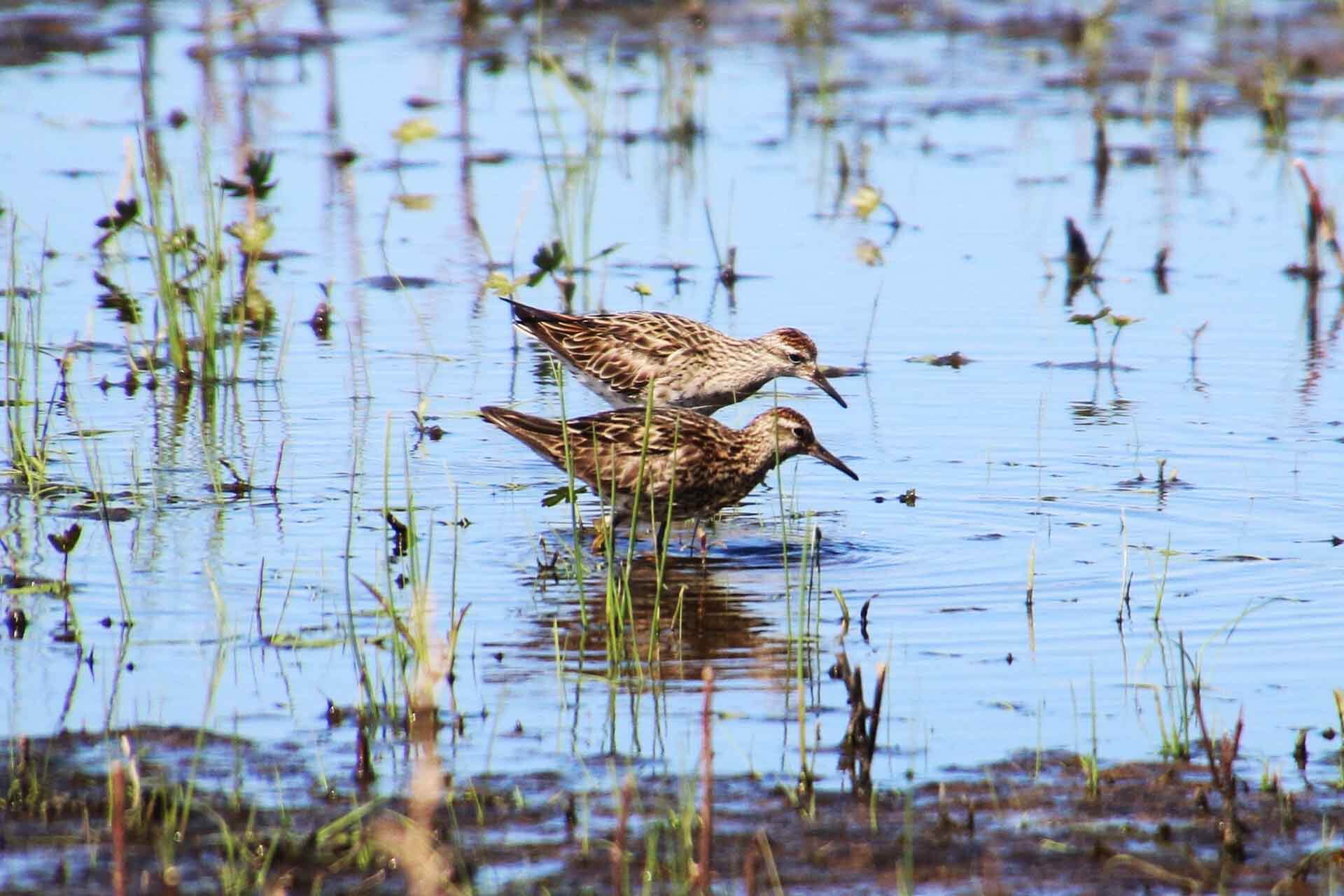
Sharp-tailed sandpiper (Calidris acuminata) in the Macquarie Marshes NSW. Image Credit: Nicola Brookhouse/DCCEEW

NSW Threatened Species Scientific Committee final determination for the red knot Calidris canutus

The red knot Calidris canutus has been listed as a vulnerable to extinction species.

The red knot is a migratory shorebird and a regular migrant to Australia during the austral summer non-breeding season and are widespread around the Australian coast at this time. In New South Wales, it is recorded in some major river estuaries and sheltered embayments along the coast, particularly in the Hunter River estuary.

The main reason for this species being eligible for listing in the Vulnerable to Extinction category is the population reduction suspected to be between 31-61% that has occurred over a three-generation timespan. The causes of this reduction are not fully understood.  This species is assessed only on the basis of its extinction risk in Australia because that scale is appropriate to the biology of the taxon due to its annual migratory movements into, and within Australia. 

More information on the species can be found in the Committees' reasons for final determination: Calidris canutus

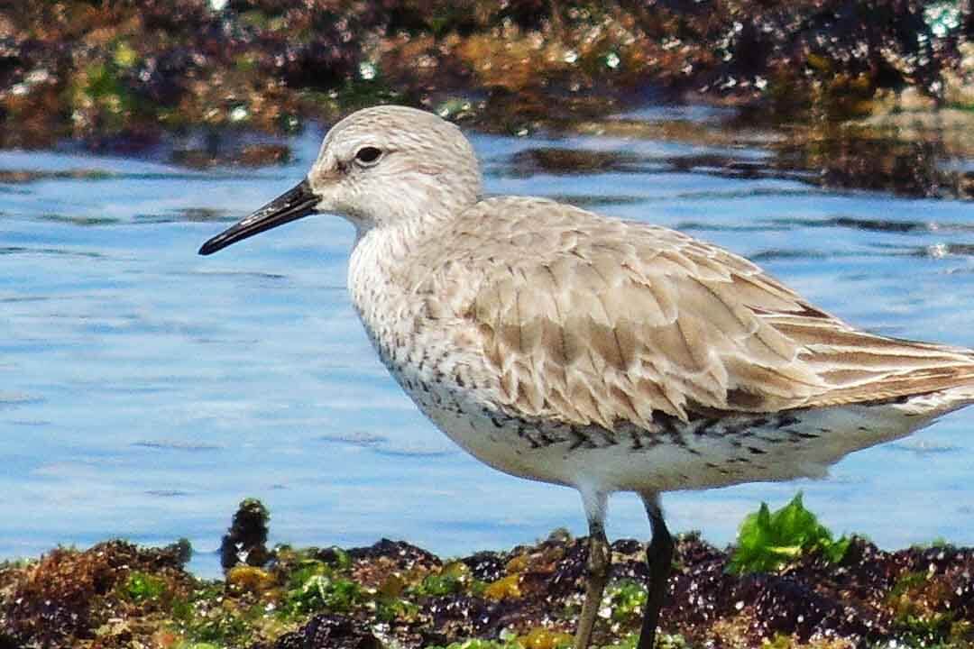
Red knot (Calidris canutus). Image Credit: Lachlan Copeland/DCCEEW

Genetically diverse seeds to restore rare River Red Gum population

Announced July 24 2026

Three thousand genetically diverse Hunter Valley River Red Gums are sinking their roots in the Upper and Lower Hunter, following planting efforts to increase the number of trees within this endangered population.

The Saving our Species team from the NSW Department of Climate Change, Energy, the Environment and Water has been working to restore river red gum habitat in the Hunter Valley, following a dramatic decline that left less than 1,000 mature trees in the region.

Twisting, towering River Red Gums (Eucalyptus camaldulensis) once stretched across tens of thousands of hectares in the Hunter Valley.

Due to land clearing, habitat fragmentation and altered flood regimes, their population hit a critical low – with just 10 per cent of their previous expanse remaining across 19 patches.

Having a small, fragmented population puts the species at risk because it reduces their ability to reproduce, and the limited gene pool makes them less adaptable to threats such as climate change and disease.

To bolster planting efforts, the team has established a regional seed bank to address low genetic diversity within the population and improve the resilience of riparian and floodplain vegetation to climate change.

Guided by genetic science, the team is sourcing seeds from a wider geographic range including multiple patches within the Hunter catchment, as well as populations further west, that can survive hotter, drier conditions.

Participating landholders are supporting planting efforts on their properties, which helps to rejuvenate their land and improves the trajectory of this endangered population.

So far, the initiative has planted close to 3,000 River Red Gum within the Hunter, thanks to partnerships with Hunter Local Land Services, Research Centre of Ecosystem Resilience at the Botanic Gardens of Sydney, Muswellbrook Shire Council, Singleton Council, Broke–Bulga Landcare, Trees in Newcastle and local landholders.

Katie Elsley, Senior Project Officer with Saving our Species at NSW Department of Climate Change, Energy, the Environment and Water, stated:

“This is an exciting project milestone and it couldn’t come at a better time with National Tree Day around the corner on Sunday 26 July.

“Partners from Muswellbrook, Scone, Aberdeen, Singleton and Broke have come together to support the recovery of this highly fragmented population.

“By combining on-ground restoration with genetic science, we’re giving this endangered population its best chance of survival.”

Kath McLoughlin, Local Land Services Team Leader – Community Engagement:, said

“Red Gums are quintessentially Australian, and we want to ensure this beautiful and iconic species remains part of the Hunter landscape for future generations.

“Healthy riparian vegetation supports healthier waterways, improves habitat for native wildlife and helps protect productive agricultural land.

"We’re so grateful to the local landholders who have embraced this opportunity to contribute to the recovery of the species while improving the environmental health of their properties.”

Maurizio Rossetto, Head of the Research Centre for Ecosystem Resilience, Botanic Gardens of Sydney, said:

"When populations become small and isolated, they lose genetic diversity, which can reduce their ability to reproduce and adapt to environmental pressures such as drought, heat and disease.

“This seed bank is helping capture a broad range of genetic material, creating a valuable resource for future restoration and a model for other regions looking to develop genetically diverse seed banks using guidance from our Restore and Renew webtool.

“This project demonstrates how conservation genetics can be applied in a practical way to improve restoration outcomes and support the long-term recovery of threatened species.”

Fenced River Red Gum planting area. Photo: DEECCW

Have Your Say On: Barwon–Darling Floodplain Management + Gwydir Valley Floodplain Management Plan + Hunter Water operating licence review 


Barwon–Darling Floodplain Management

Consultation period: 20th July 2026 - 9th August 2026

The NSW Department of Climate Change, Energy, the Environment and Water is seeking feedback on the Barwon–Darling Valley Floodplain Management Plan.

The NSW Department of Climate Change, Energy, the Environment and Water is reviewing the floodplain management plan for the Barwon–Darling Valley Floodplain and is seeking your feedback.

NSW floodplain management plans are valid for 10 years from their commencement date. The plans set the rules for flood work development on floodplains in rural areas, including what type of flood works can be constructed and where. 

Under the Water Management Act 2000, floodplain management plans must be reviewed in the 5 years before they expire to ensure they continue to effectively support the needs of communities, landholders and the environment.

While an initial review was undertaken in 2022 under previous legislative requirements, this is an opportunity to provide feedback on how the plan is working and whether it can be improved.

The department will consider all submissions and publish a review report with the findings on its Barwon-Darling Valley floodplain page. The review report will be used to inform the replacement plan.

Download Submission form for the review of the Barwon–Darling Valley Floodplain Management Plan ( PDF 278.73KB)

Gwydir Valley Floodplain Management Plan 

Consultation period: 20th July 2026 - 9th August 2026

You are also invited to provide feedback on the Gwydir Valley Floodplain Management Plan which is also open for consultation from Monday 20 July to Sunday 9 August 2026. Visit the department’s Gwydir Valley floodplain page to find out more and have your say.

The NSW Department of Climate Change, Energy, the Environment and Water is reviewing the floodplain management plan for the Gwydir Valley Floodplain and is seeking your feedback.

NSW floodplain management plans are valid for 10 years from their commencement date. The plans set the rules for flood work development on floodplains in rural areas, including what type of flood works can be constructed and where. 

Under the Water Management Act 2000, floodplain management plans must be reviewed in the 5 years before they expire to ensure they continue to effectively support the needs of communities, landholders and the environment.

While an initial review was undertaken in 2022 under previous legislative requirements, this is an opportunity to provide feedback on how the plan is working and whether it can be improved.

The department will consider all submissions and publish a review report with the findings on its Gwydir Valley floodplain page. The review report will be used to inform the replacement plan.

Download Submission form for the review of the Gwydir Valley Floodplain Management Plan (PDF 278.87KB)

Hunter Water operating licence review

Consultation period: 21st July 2026 - 4th September 2026

The Independent Pricing and Regulatory Tribunal (IPART) is reviewing Hunter Water’s 2022-2027 operating licence before it expires on 30 June 2027.

The licence sets the terms and conditions that Hunter Water must follow when providing water, wastewater and stormwater services to its customers across the Lower Hunter region. The licence requirements aim to protect customers, public health, the environment and service quality.

As part of the review, IPART will consider if the licence continues to work as intended, and understand if any changes are needed to reflect issues that have emerged since the licence was granted. 

IPART have prepared an issues paper that includes 20 questions to help you prepare your response to the paper.

Independent Pricing and Regulatory Tribunal (IPART)

Email: compliance@ipart.nsw.gov.au

Agency website: https://www.ipart.nsw.gov.au/

Consultation webpage: www.ipart.nsw.gov.au/review/water/hunter-water-operating-licence-review-2026-27

Western Sydney’s newest National Park revealed: Gulguer National Park

On Sunday July 26 2026 the NSW Government announced a new national park more than three times the size of Centennial Parklands will be created in Western Sydney and stated this will be a major boost for affordable recreation and threatened wildlife.

''The Minns Labor Government is establishing Gulguer National Park, west of Bringelly, offering a new backyard for walkers, mountain bikers, nature lovers and our native animals to explore.'' the government said

As Western Sydney continues to grow, the 1,100-hectare park will give families, friends and communities a new and affordable place to enjoy the local natural beauty.''

''The park will add around 700 hectares of new land to the existing environmentally protected areas at Bents Basin State Conservation Area and Gulguer Nature Reserve, creating a destination where recreation, conservation and Aboriginal heritage come together.''

''Named after the swirling waters of the Nepean River, the new park will preserve significant Aboriginal cultural heritage, including rock art, Aboriginal artefacts and shelters.''

''Gulguer National Park will protect some of Western Sydney's most important habitat for at least 28 threatened species, including the southern greater glider, powerful owl, giant burrowing frog, eastern coastal free-tailed bat and Cumberland and Dural land snails.''

''It will also provide stronger protection for the critically endangered Shale Sandstone Transition Forest and Sydney Turpentine-Ironbark Forest.''

''Land acquired through the Cumberland Plain Conservation Plan is helping create Gulguer National Park, which protects important habitat while supporting the delivery of around 73,000 new homes in Western Sydney.''

This is the second national park in Western Sydney to be delivered by the Minns Government. The first is Warranmadhaa National Park along the Georges River between Long Point and Appin.'' the government stated

NSW’s network of around 900 parks and reserves hosted a record 65.6 million visits last year, showing just how much families, communities and visitors value time outdoors.

Deputy Premier of New South Wales and Minister for Western Sydney, Prue Car said:

“For too long, families in Western Sydney have missed out on access to outdoor spaces that other parts of the city take for granted.

“That’s why the Minns Labor Government is delivering the quality recreational areas Western Sydney communities deserve while protecting our local wildlife and natural heritage.

“At a time when families are under pressure, this new National Park will give locals a world-class destination right in their own backyard.”

Minister for Climate Change and the Environment Penny Sharpe said:

“The Minns Labor Government is making it easier and more affordable for Western Sydney families, visitors and local communities to enjoy the great outdoors.

“The new national park will protect threatened species like the powerful owl and southern greater glider.

“It is part of our ongoing commitment to boost conservation in Western Sydney, to ensure our precious native creatures and plants exist here for generations to come.”

Minister for Planning and Public Spaces Paul Scully said:

“The Cumberland Plain Conservation Plan allows Western Sydney to grow while permanently protecting important habitat.

“Gulguer National Park is a major part of that work, supporting new homes and infrastructure while securing environmentally significant land for future generations.”

Gulguer National Park

From: www.environment.nsw.gov.au/topics/parks-reserves-and-protected-areas/establishing-new-parks-and-protected-areas/changes-to-parks/gulguer-national-park

The creation of Gulguer National Park in western Sydney marks the first stage of a protected landscape that will eventually connect Gulguer Nature Reserve and Bents Basin State Conservation Area with Burragorang State Conservation Area.

This new national park is located 5 kilometres south of Silverdale and 10 kilometres west of Bringelly. It is being created as part of the Cumberland Plain Conservation Plan that allows western Sydney to grow while permanently protecting important habitat.

The park will eventually expand to over 1,100 hectares in size. There are plans for additional land to be added to the park in the near future.

The park will protect habitat for at least 28 threatened species, including Cumberland and Dural land snails, southern greater glider, powerful owl, giant burrowing frog and eastern coastal free-tailed bat.

It also features areas of critically endangered Shale Sandstone Transition Forest and Sydney Turpentine–lronbark Forest ecological communities.

Important Aboriginal cultural heritage will also be protected and the land’s management as a national park will enable greater access to Country for Aboriginal people.

Public access to the new park is currently only available via Bents Basin State Conservation Area. Opportunities for visitors to access the park will increase over time, with the expansion of the park and creation of infrastructure to support appropriate public use.

Photo: Land proposed for restoration. Picture: DCCEEW

National Parks protect Southern Right Whales with new ‘stay away’ distance of up to 500 metres

The NSW National Parks and Wildlife Service (NPWS) has issued a Special Order for all vessels to stay at least 500 metres, and swimmers 100m, away from all Southern Right Whales in NSW waters.

The Order will be in place until 30 November 2026, when the breeding and calving season ends in NSW.

Southern Right Whales attract a lot of attention as they stay close to beaches and move slowly on the surface. Although incredibly rare, they are easily spotted when they visit.

The Order comes after a mother and calf were recently spotted off Sydney, with curious boaters and locals venturing close to the pair.

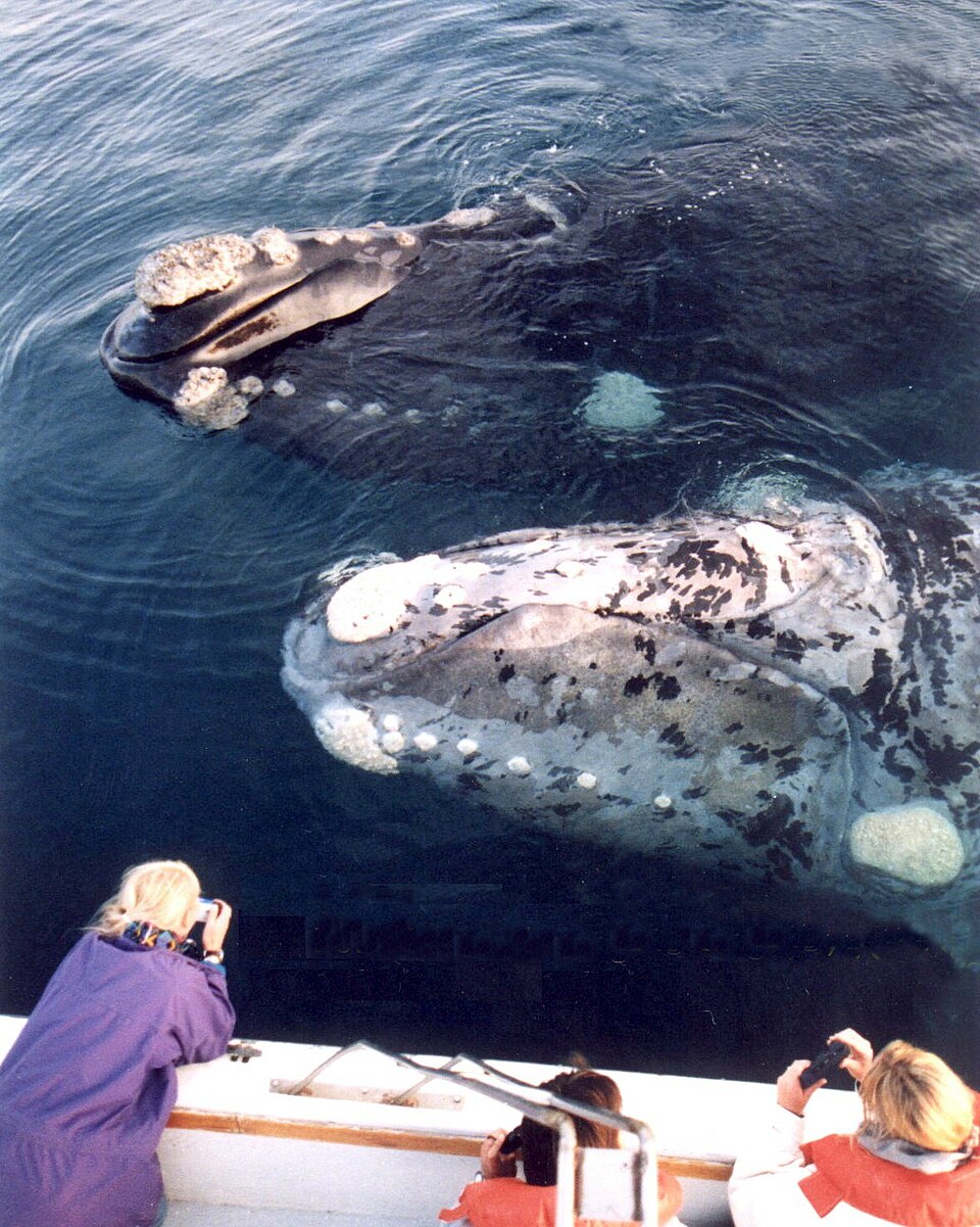
The NPWS citizen science project ‘Right Whale ID’ has tracked individual whales through their unique white facial callosities for the past 6 years. Research has found that even a single swimmer approaching too enthusiastically can trigger a significant negative behavioural response in the whale.

Identifying one of the handful or so Southern Right Whales off the NSW Coast each whale season, as opposed to one of the 40,000 humpback whales, is fairly simple.

Any slow-moving, 14-16 metre long whale which is 500m or less off an ocean beach could be a Southern Right Whale.

Identifying features include:

  • a distinctive V-shaped blow when they exhale
  • large broad body size, absence of a dorsal fin
  • white markings (skin growths) on their faces and heads known as ‘callosities’
  • the tail/fluke is geometrically angular and usually black on both top and bottom sides.

Two distinctive colouration patterns. Photo courtesy: Leonardo Lanza 

Southern Right Whale tail fluke. Photo courtesy Michael Cantanzariti

Southern Right Whales have a distinctive V-shaped blow when they exhale

Unlike Humpbacks, mother and calf Southern Right Whales spend more than 90 per cent of their time in waters shallower than 20m, and often less than 500m from shore. While nursing , they move very slowly, engaging in a still, energy-saving behaviour called ‘logging’, which is floating at the surface for long periods.

These behaviours make them highly susceptible to disturbance from overly curious people swimming, paddling or boating too close for the mum’s comfort.

Disturbances can cost the animals precious energy budget as their responses often include significant increases in swim distances as they try to evade them. The disturbance effect is seen in tracking data over subsequent days.

NPWS asks people to comply with the keep-away distances to help protect these mammals.

Members of the public, partner organisations and NPWS staff will collect witness accounts when people venture too close to Southern Right Whales and proceed with investigations where warranted. Non-compliance could result in fines or court appearances.

If anyone spots a Southern Right Whale, please report to NPWS or ORRCA hotlines on 1300 072 757 (13000 PARKS) or (02) 9415 3333 immediately, which allows the Right Whale ID team to get on site as soon as possible.

NSW National Parks and Wildlife Service Marine Wildlife Project Officer Andy Marshall said:

“Doing the right thing by Southern Right Whales means the southeast Australian population has a better chance of recovering.

“I would like to think that future generations will be able to see these incredible animals and be awed by them, in the same way we are today.”

Distances prescribed under the Special Protection Approach Distance Order

Vessels, aircraft, swimmers - Special Protection Approach Distance

  • For vessels including jet skis, surfboards- Stay away 500 metres
  • Operating a crewed aircraft- Stay 610m away – either above or to the side of the whale
  • When swimming including snorkelling and diving- Stay away 100 metres

Mother and calf in Hermanus. Photo courtesy Martin Etsebeth

Scuba divers underestimate how much damage they do to coral reefs – we’ve watched hundreds to find out why

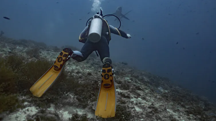
A diver in the foreground with a flipper touching a rock and a shark in the distance.
A scuba diver resting on a reef in Leyte, Philippines. Bing Lin
Ronan Roche, Bangor University and Bing Lin, University of Sydney

Scuba diving is often presented as a success story for marine ecotourism.

Each year millions of people dive beneath the surface to experience coral reefs first-hand. Scuba diving generates income for coastal communities and helps people understand why coral reefs matter.

But that success also brings a conservation challenge. It brings tourists into direct contact with sensitive coral ecosystems, where a misplaced fin, hand or camera can add to the stresses reefs already face. At a time when reefs are severely threatened, understanding how divers might help, or harm, those ecosystems has never been more important.

Between us, we have spent thousands of hours underwater as both dive professionals and marine scientists. In this time, we realised something uncomfortable: even people who admire and value coral reefs can unintentionally contribute to their decline through their actions underwater.

That observation led us to ask a simple question: how much impact are divers actually having on coral reefs underwater – and do they realise it?

For our research, we followed hundreds of recreational scuba divers, carefully documenting their behaviour underwater. We then surveyed those same divers afterwards to compare what they thought they had done, with what had actually happened.

We spent hundreds of hours following, observing, and surveying 732 scuba divers across world-famous dive destinations in Indonesia and the Philippines. We recorded every time a diver touched the reef and what was happening at that moment. The results surprised us.

Divers touched or hit the reef, on average, about once every four minutes. More than 40% of those contacts caused visible damage, including broken corals or sediment deposited onto living coral. Perhaps most striking, we found that most damaging contacts were accidental and often went entirely unnoticed.

Divers in our study also expressed strong environmental values, and many saw themselves as better than average at controlling buoyancy and avoiding reef contact. At least 69% of divers responding to our survey rated themselves “above average” in their ability to avoid intentional reef contacts, and 86% as “above average” in their ability to avoid accidental contacts.

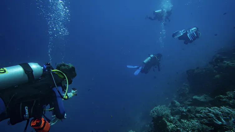
A researcher following scuba divers to monitor behaviour of divers. Underwater shot, one diver in foreground.
A researcher following scuba divers for this project. Bing Lin

But when we compared their survey responses with our underwater observations, divers underestimated how often they contacted the reef by almost fivefold. The divers making the most contacts also tended to be the most overconfident about their underwater performance.

This pattern is consistent with the Dunning-Kruger effect, a well-established psychological phenomenon in which people with lower skill levels are often least able to recognise their own limitations. For coral reefs, this creates a conservation problem: people may not change their behaviour if they do not realise they are part of the problem.

Influenced by others

Underwater behaviour was also surprisingly social. When one diver hit or touched the reef, nearby divers became more likely to do the same. This is an example of social contagion, where people unconsciously take behavioural cues from those around them. Underwater, the actions of other divers can subtly reshape what feels acceptable creating social norms that may be detrimental to coral reef ecosystems.

Seeing sharks, turtles, manta rays or other charismatic species, increased the likelihood of intentional, unintentional and damaging reef contacts. In other words, the moments that often inspire people to value coral reefs might also be the same moments in which those reefs are most vulnerable.

This means dive sites famous for abundant marine life require particularly careful management. Smaller group size and appropriate viewing distances could help reduce impacts, especially during peak encounter periods. Instructors and dive guides also have a crucial role to play, by modelling good behaviour and reminding divers that the best way to enjoy marine life is with space and respect.

The encouraging message is that effects of scuba diving on coral reefs are not inevitable. Better buoyancy training, clearer pre-dive briefings, post-dive feedback and stronger guide leadership could all help reduce reef contact. Equipment also matters. We found that the use of accessories such as underwater cameras, muck sticks (rods used by divers to stabilise themselves) and gloves was associated with more frequent reef contacts.

A scuba diver stirs up sediment at a coral restoration site in Bali, Indonesia.
A scuba diver stirs up sediment at a coral restoration site in Bali, Indonesia. Bing Lin.

Some coral reef dive locations have implemented conservation rules restricting these items, although such measures can be unpopular within the diving community.

Eco-certification schemes that take a broader look at the impact of scuba diving and sustainability also offer a promising route for change. In our study, Green Fins certification (an international initiative to promote responsible marine tourism) was linked to fewer intentional reef contacts, particularly among higher-performing dive centres.

But certification alone is unlikely to solve the problem unless it helps create a wider shift in expectations across the industry. Understanding the psychology behind how people act underwater may be one of the most effective ways to help ensure that reef tourism supports conservation and helps relieve pressures on fragile ecosystems.The Conversation

Ronan Roche, Lecturer, School of Ocean Sciences, Bangor University and Bing Lin, Postdoctoral Fellow in the Thriving Oceans Research Hub, School of Geosciences, University of Sydney

This article is republished from The Conversation under a Creative Commons license. Read the original article.

Falls in whale sightings, rare seabirds appearing – is something unusual happening in the Southern Ocean?

Mary-Anne Lea, University of Tasmania and Christopher Chapman, UNSW

In late June, whale watchers in southwest Western Australia sounded the alarm. They had seen far fewer humpback whales at a time when they normally migrate up from the Southern Ocean to calve and feed. Numbers were 60% below normal.

A week later, birdwatchers spotted a “once in a lifetime event” as large numbers of rarely seen albatrosses and petrels appeared off Australia’s east coast, thousands of kilometres from their usual foraging grounds deep in the Southern Ocean. Many birds were in poor condition.

The sightings came just weeks after a dying migratory seabird was confirmed as Australia’s first case of highly pathogenic H5N1 bird flu.

These sightings raise troubling questions. Seabirds and marine mammals such as whales use ocean currents and weather to travel long distances to feeding and breeding grounds. If these species are changing their behaviour, it could be a sign of altered conditions in the Southern Ocean.

We know the world’s oceans are running very hot. Marine heatwaves can affect any part of the ocean – even frigid Antarctic regions. If species are used to water temperatures around 2–6°C, a sudden boost of a couple of degrees can upend ecosystems. If the heatwave lingers, the cumulative effect can be much bigger.

We don’t yet know for sure, as monitoring in the Southern Ocean is limited. But we know marine heatwaves can alter currents, weather conditions and prey availability.

Oceans running hot

Since February, a large and persistent marine heatwave has affected waters around Australia’s Heard Island and McDonald Islands, stretching as far south as the edge of Antartica’s sea ice. These remote islands are extraordinarily rich in life. But researchers have found their waters are exposed to damage from climate change.

figure showing Marine heatwave in southern ocean
A long-lasting marine heatwave is affecting the Southern Indian Ocean, as shown in these monthly averaged temperature anomalies. Heard Island is roughly in the center of the image. Chris Chapman/NOAA-OISST, CC BY-NC-ND

The southern Tasman Sea has also endured a marine heatwave since at least April, likely due to the fact we are coming out of successive La Niñas.

Both areas of ocean are among the fastest-warming on the planet. The steady drumbeat of climate change can make marine heatwaves more severe, more frequent and longer-lasting.

It’s possible this marine heatwave is putting pressure on seabird and whale food supply. But there remain significant gaps in our knowledge.

One reason is that extreme events don’t occur very often. Given this, it’s worth looking at past events.

Devastation from ‘the Blob’

Between 2014 and 2016, the North Pacific Ocean was hit by an event scarier than any monster movie.

A huge, long-lasting and extreme marine heatwave stayed in place for many months. It became known as “the Blob”.

Water temperatures were between 2°C and 6°C above normal. While this may not seem like a drastic change, it led to widespread ecosystem disruption. At least 240 species were found outside their normal ranges – some further north than ever recorded.

It’s hard to overstate how extensive its effects were. Kelp forests disappeared. Millions of starfish dissolved into goo. Whales died. Seabirds starved. Toxic algal blooms appeared.

It’s possible reported falls in whale numbers and unusual sightings of seabirds might be linked to a smaller version of the Blob in the cold Southern Ocean.

We already know marine heatwaves can disrupt the feeding behaviour of marine predators such as little penguins in Tasmania.

Our research has shown marine heatwaves lead to significant shifts in the types of zooplankton – tiny floating animals – found in coastal seas off Tasmania. Zooplankton are important food sources for seabirds, whales and fish.

As early as 1997–98, researchers found warmer surface waters in the Southern Ocean made it harder for female Antarctic fur seals to find prey while raising their pups.

Deaths of pups and adults are becoming more common in the South Atlantic. The population has fallen by around 1.5 million in the 15 years to 2022. The species was once considered abundant. But it’s now has recently listed as endangered.

We don’t know what we don’t know

By studying past events, scientists now have a better understanding of how marine ecosystems respond to extreme events.

Even so, there’s a lot we don’t know. For example, we have strong evidence climate change is affecting Antarctic krill. But we still don’t fully understand how a particular marine heatwave affects these tiny crustaceans or how ocean predators such as whales and seabirds respond during such events.

In short, our knowledge of how extreme events affect ecosystems isn’t keeping pace with climate change.

For scientists to understand how vulnerable species respond to environmental triggers, we need to monitor key species over the long term, while tracking environmental conditions in breeding and foraging areas and their food sources.

This type of monitoring is expensive, time-consuming and challenging. It would require national coordination, international collaboration and sustained support. But if we want to understand what’s driving ecosystem changes affecting local and migratory species in our waters, it will be necessary.

Once up and running, these dynamic monitoring systems would help authorities respond quickly by, say, reducing or redirecting fishing boats if there’s a sudden drop in fish numbers. Monitoring would also show areas in need of better protection.

We know changes are taking place in these cold oceans. Fewer whales and rare seabird sightings are a warning sign. If we don’t have better monitoring, we will keep flying blind as global warming accelerates.The Conversation

Mary-Anne Lea, Adjunct Senior Research Fellow in Marine/Polar Predator Ecology, University of Tasmania and Christopher Chapman, Senior Lecturer in Oceanography, UNSW

This article is republished from The Conversation under a Creative Commons license. Read the original article.

PNHA Activities 2026

Our walks for 2026 are listed below. 

You are very welcome to bring friends and older children on these outings. Please book by emailing pnhainfo@gmail.com and include  your PHONE NUMBER so we can contact you in case of changes because of weather etc. 

Looking forward to getting out and about in our lovely area! 

Your PNHA Committee

Pittwater Natural Heritage Association

The Pittwater Natural Heritage Association has been formed to act to protect and preserve the Pittwater areas major and most valuable asset - its natural heritage.

PNHA is an incorporated association seeking broad based community membership and support to enable it to have an effective and authoritative voice speaking out for the preservation of Pittwater's natural heritage.

Our Aims

  • To raise public awareness of the conservation value of the natural heritage of the Pittwater area: its landforms, watercourses, soils and local native vegetation and fauna.
  • To raise public awareness of the threats to the long-term sustainability of Pittwater's natural heritage.
  • To foster individual and community responsibility for caring for this natural heritage.
  • To encourage Pittwater Council and the NSW Government to adopt and implement policies and works which will conserve, sustain and enhance the natural heritage of Pittwater.

Some of our interests and concerns include:

  • Native Tree Canopy
  • "Wildlife Friendly" Gardens
  • Weed Infestation
  • Keeping our Waterways Healthy
  • Beaches and Dunes

Act to Preserve and Protect!

If you would like to join us, please fill out the Membership Form. Visit: https://pnha.org.au

Sunday April 26 Fauna: Underpass below Mona Vale Rd East, Ingleside.

If you missed this walk last year, here’s your chance to see how fauna can move between areas of bushland, so important for finding territory, mates and food. 

Meet 9am at corner of Ingleside Rd and Laurel Rd East. Walk ends about 11am.

Saturday May 23: PNHA stall at Avalon Car Boot Sale, Dunbar Park Avalon.

From 8am to 2pm, we’ll offer Information on identifying and controlling weeds. See our posters about invertebrates in local gardens. Our famous $2 local flora, fauna and scenery cards will be for sale. Come and have a chat. 

Sunday May 24: Walk in Red Hill Bushland Reserve, Beacon Hill

Meet 9am on Lady Penrhyn Drive opposite no. 41A, close to the open gate. Flora, birds, views. Walk ends about 11.30. 

Sunday June 28: Crown to the Sea Walk, Newport

Meet 9am please note that the meeting point is on Burke Rd next to Porter Reserve. Walk ends about 12 noon. This walk goes through several very different bushland reserves with coastal heath and littoral rainforest.

Wildflowers, ferns and coastal views. Moderate fitness needed for some steep tracks and many steps. Limit: 15 people so please book early. We will provide the Crown to the Sea map to participants on booking.

Sunday July 26: Ingleside Chase Reserve

Meet 9am at end of Irrawong Rd North Narrabeen, walk ends about 11am. Birds and swamp forest along Mullet Creek. Swamp Mahoganies will be flowering attracting birds. Binoculars a must for this walk.

Sunday August 23: Spring in the Bush

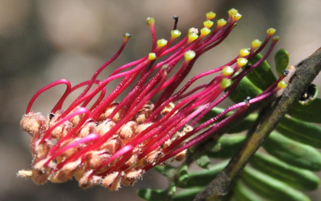
Meet 9am at corner of Mallawa Rd and Bulara St, Terrey Hills. Walk ends about 11am. With a focus on botany, we’ll see flowering plants in the Proteaceae plant family, waratahs, endangered Grevillea caleyi , right, and others in the major Australian Proteaceae plant family. Birds, too. 

Sunday September 27: The Chiltern Track, Ku-ring-gai N.P.

Meet 9am at track entrance with barred gate on Chiltern Rd Ingleside. Walk ends about 11am. One of our favourite walks to see Sydney sandstone flora in spring. Native plant species list available. Birds too, often a Yellow-tufted Honeyeater here. 

Sunday October 25: Katandra by Night

Meet 6.45pm at Katandra Bushland Sanctuary on Lane Cove Rd Ingleside. Walk ends about 8.45pm. Sunset is about 7.15. The bush by night is wonderful. We hope to see fireflies again as on previous walks here in October. Bring a torch, or headtorch, preferably with a red light option so as not to dazzle possums. Moderate fitness needed for the bush track and steps. Limit: 15 people, so please book early. 

Sunday November 22: Deep Creek Reserve

Meet 9am in Deep Creek reserve, off Wakehurst Parkway. Walk ends about 11am. Birds and bushland. From the bridge across the creek we may see Dollarbirds, summer breeding migrants that nest in hollows, with their youngsters. Black Bitterns have been observed along the creek margins, so bring binoculars. 

Solar for apartment residents: Co-funding

Less than 2% of apartment buildings in NSW have solar installed, but the NSW Department of Climate Chnage, Energy, the Environment and Water are on a mission to change this.

Their Solar for Apartment Residents grant is co-funding shared solar panel installations on eligible apartment buildings and multi-unit dwellings and has already helped thousands of households.

They’ve extended the program to help more homeowners and renters reduce their energy bills and have also allocated extra funds through a separate Boost grant to help priority communities too.

Application closes: 4 December 2026, 5:00 pm

Share this with your Owners Corporation or Stata Manager and check your building's eligibility at: www.nsw.gov.au/grants-and-funding/solar-for-apartment-residents-soar-grant-program


Dedicated alpine weather page part of latest BOM website improvements

The Bureau of Meteorology has delivered its latest website update.

In this release navigation has improved, there’s a new dedicated alpine weather page in time for the ski season, and the weather map has more place names.

Bureau of Meteorology CEO Dr Stuart Minchin said the update was a direct response to community feedback.

“Since launch, we've had requests for more locations to be added to the weather map,” Dr Minchin said.

“Our website is there to serve all Australians. We've now added more than 100 place names, primarily in the Northern Territory and Queensland.

“We'll be adding hundreds more in the months ahead.”

The weather map will now remember users’ most recent pan and zoom position, keeping the settings the same for the next time the page is viewed.

For example, if your last visit was a maximum zoomed-in view of Mount Isa, Queensland, this is the view you'll see next time you visit the rain radar.

“Changes like these will make it easier for everyone to find what they need,” Dr Minchin said.

Other changes include the UV Index being restored to the hourly forecast and updating the presentation of flood warnings.

A new alpine weather page provides weather map layers for snow, wind and temperature, and forecasts for snow resorts, towns, and remote areas in Australia's alpine regions in one page.

The updated Alpine regions page provides weather maps and forecasts for snow resorts, towns, and remote areas in Australia's alpine regions.

Alpine regions offers information across 2 tabs:

  • Forecasts – alpine districts and locations
  • Map – 3 hourly snow, wind and temperature forecasts.

Navigating the website has become easier with changes to tabs and page layouts on a number of key pages such as Forecasts and observations, Coasts and Oceans and state, territory and district pages.

“People have told us that navigating to forecasts and observations for districts and states was hard,” Dr Minchin said.

“We’ve paid close attention to this feedback.

“Combined with last month's search improvements, this will make it easier for regional web users to find out if their district is expecting rain or sunshine.”

Updates will continue to be made to the website in response to the feedback received from the community.

Information about recent changes is available at bom.gov.au/website-help/website-updates

The ski season starts on the June long weekend and runs until October's long weekend in NSW. 

The Kiandra Alpine Club's Snow Carnival, 1900. Photo: Kerry

Birdwood Park Bushcare Group Narrabeen

The council has received an application from residents to volunteer to look after bushland at 199/201 Ocean street North Narrabeen.

The group will meet once a month for 2-3 hours at a time to be decided by the group. Activities will consist of weeding out invasive species and encouraging the regeneration of native plants. Support and supervision will be provided by the council.

If you have questions or are interested in joining the group please email the council on bushcare@northernbeaches.nsw.gov.au

Sydney Wildlife (Sydney Metropolitan Wildlife Services) Needs People for the Rescue Line

We are calling on you to help save the rescue line because the current lack of operators is seriously worrying. Look at these faces! They need you! 

Every week we have around 15 shifts either not filled or with just one operator and the busy season is around the corner. This situation impacts on the operators, MOPs, vets and the animals, because the phone line is constantly busy. Already the baby possum season is ramping up with calls for urgent assistance for these vulnerable little ones.

We have an amazing team, but they can’t answer every call in Spring and Summer if they work on their own.  Please jump in and join us – you would be welcomed with open arms!  We offer lots of training and support and you can work from the office in the Lane Cove National Park or on your home computer.

If you are not able to help do you know someone (a friend or family member perhaps) who might be interested?
Please send us a message and we will get in touch. Please send our wonderful office admin Carolyn an email at  sydneywildliferescueline@gmail.com

622kg of Rubbish Collected from Local Beaches: Adopt your local beach program

Sadly, our beaches are not as pristine as we'd all like to think they are. 

Surfrider Foundation Northern Beaches' Adopt A beach ocean conservation program is highlighting that we need to clean up our act.

Surfrider Foundation Northern Beaches' states:
''The collective action by our amazing local community at their monthly beach clean events across 9 beach locations is assisting Surfrider Foundation NB in the compilation of quantitative data on the volume, type and often source of the marine pollution occurring at each location.

In just 6 sessions, clear indicators are already forming on the waste items and areas to target with dedicated litter prevention strategies.

Plastic pollution is an every body problem and the solution to fixing it lies within every one of us.
Together we can choose to refuse this fate on our Northern beaches and turn the tide on pollution. 
A cleaner coast together !''

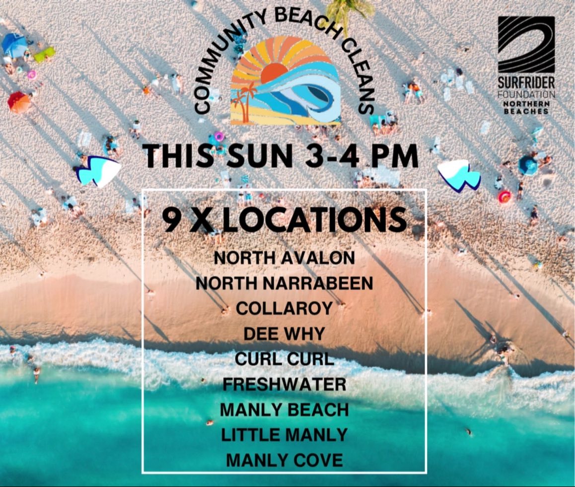
Join us - 1st Sunday of the month, Adopt your local for a power beach clean or donate to help support our program here. https://www.surfrider.org.au/donate/

Event locations 
  • Avalon – Des Creagh Reserve (North Avalon Beach Lookout)
  • North Narrabeen – Corner Ocean St & Malcolm St (grass reserve next to North Narrabeen SLSC)
  • Collaroy– 1058 Pittwater Rd (beachfront next to The Beach Club Collaroy)
  • Dee Why Beach –  Corner Howard Ave & The Strand (beachfront grass reserve, opposite Blu Restaurant)
  • Curl Curl – Beachfront at North Curl Curl Surf Club. Shuttle bus also available from Harbord Diggers to transport participants to/from North Curl Curl beach. 
  • Freshwater Beach – Moore Rd Beach Reserve (opposite Pilu Restaurant)
  • Manly Beach – 11 South Steyne (grass reserve opposite Manly Grill)
  • Manly Cove – Beach at West Esplanade (opposite Fratelli Fresh)
  • Little Manly– 55 Stuart St Little Manly (Beachfront Grass Reserve)
… and more to follow!

Surfrider Foundation Northern Beaches

This Tick Season: Freeze it - don't squeeze it

Notice of 1080 Poison Baiting

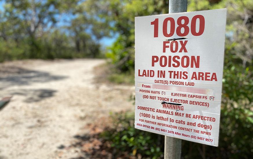
The NSW National Parks and Wildlife Service (NPWS) will be conducting a baiting program using manufactured baits, fresh baits and Canid Pest Ejectors (CPE’s/ejectors) containing 1080 poison (sodium fluoroacetate) for the control of foxes. The program is continuous and ongoing for the protection of threatened species.

This notification is for the period to 31 July 2026 at the following locations:

  • Garigal National Park
  • Lane Cove National Park (baits only, no ejectors are used in Lane Cove National Park)
  • Ku-ring-gai Chase National Park
  • Sydney Harbour National Park – North Head (including the Quarantine Station), Dobroyd Head, Chowder Head & Bradleys Head managed by the NPWS
  • The North Head Sanctuary managed by the Sydney Harbour Federation Trust
  • The Australian Institute of Police Management, North Head

DO NOT TOUCH BAITS OR EJECTORS

All baiting locations will be identifiable by signs.

Please be reminded that domestic pets are not permitted on NPWS Estate. Pets and working dogs may be affected (1080 is lethal to cats and dogs). Pets and working dogs must be restrained or muzzled in the vicinity and must not enter the baiting location. Penalties apply for non-compliance.

In the event of accidental poisoning seek immediate veterinary assistance.

For further information please call the local NPWS office on:

NPWS Sydney North (Middle Head) Area office: 9960 6266

NPWS Sydney North (Forestville) Area office: 9451 3479

NPWS North West Sydney (Lane Cove NP) Area office: 8448 0400

NPWS after-hours Duty officer service: 1300 056 294

Sydney Harbour Federation Trust: 8969 2128

Volunteers for Barrenjoey Lighthouse Tours needed

Details:

Johnson Brothers Mitre 10 Recycling Batteries: at Mona Vale + Avalon Beach

Over 18,600 tonnes of batteries are discarded to landfill in Australia each year, even though 95% of a battery can be recycled!

That’s why we are rolling out battery recycling units across our stores! Our battery recycling units accept household, button cell, laptop, and power tool batteries as well as mobile phones! 

How To Dispose Of Your Batteries Safely: 

  1. Collect Your Used Batteries: Gather all used batteries from your home. Our battery recycling units accept batteries from a wide range of products such as household, button cell, laptop, and power tool batteries.
  2. Tape Your Terminals: Tape the terminals of used batteries with clear sticky tape.
  3. Drop Them Off: Come and visit your nearest participating store to recycle your batteries for free (at Johnson Brothers Mitre 10 Mona Vale and Avalon Beach).
  4. Feel Good About Your Impact: By recycling your batteries, you're helping support a healthier planet by keeping hazardous material out of landfills and conserving resources.

Environmental Benefits

  • Reduces hazardous waste in landfill
  • Conserves natural resources by promoting the use of recycled materials
  • Keep toxic materials out of waterways 

Reporting Dogs Offleash - Dog Attacks to Council

If the attack happened outside local council hours, you may call your local police station. Police officers are also authorised officers under the Companion Animals Act 1998. Authorised officers have a wide range of powers to deal with owners of attacking dogs, including seizing dogs that have attacked.

You can report dog attacks, along with dogs offleash where they should not be, to the NBC anonymously and via your own name, to get a response, at: https://help.northernbeaches.nsw.gov.au/s/submit-request?topic=Pets_Animals

If the matter is urgent or dangerous call Council on 1300 434 434 (24 hours a day, 7 days a week).

If you find injured wildlife please contact:
  • Sydney Wildlife Rescue (24/7): 9413 4300 
  • WIRES: 1300 094 737

Plastic Bread Ties For Wheelchairs

The Berry Collective at 1691 Pittwater Rd, Mona Vale collects them for Oz Bread Tags for Wheelchairs, who recycle the plastic.

Berry Collective is the practice on the left side of the road as you head north, a few blocks before Mona Vale shops . They have parking. Enter the foyer and there's a small bin on a table where you drop your bread ties - very easy.

A full list of Aussie bread tags for wheelchairs is available at: HERE 


Stay Safe From Mosquitoes 

NSW Health is reminding people to protect themselves from mosquitoes when they are out and about.

NSW Health states Mosquitoes in NSW can carry viruses such as Japanese encephalitis (JE), Murray Valley encephalitis (MVE), Kunjin, Ross River and Barmah Forest. The viruses may cause serious diseases with symptoms ranging from tiredness, rash, headache and sore and swollen joints to rare but severe symptoms of seizures and loss of consciousness.

A free vaccine to protect against JE infection is available to those at highest risk in NSW and people can check their eligibility at NSW Health.

People are encouraged to take actions to prevent mosquito bites and reduce the risk of acquiring a mosquito-borne virus by:
  • Applying repellent to exposed skin. Use repellents that contain DEET, picaridin, or oil of lemon eucalyptus. Check the label for reapplication times.
  • Re-applying repellent regularly, particularly after swimming. Be sure to apply sunscreen first and then apply repellent.
  • Wearing light, loose-fitting long-sleeve shirts, long pants and covered footwear and socks.
  • Avoiding going outdoors during peak mosquito times, especially at dawn and dusk.
  • Using insecticide sprays, vapour dispensing units and mosquito coils to repel mosquitoes (mosquito coils should only be used outdoors in well-ventilated areas)
  • Covering windows and doors with insect screens and checking there are no gaps.
  • Removing items that may collect water such as old tyres and empty pots from around your home to reduce the places where mosquitoes can breed.
  • Using repellents that are safe for children. Most skin repellents are safe for use on children aged three months and older. Always check the label for instructions. Protecting infants aged less than three months by using an infant carrier draped with mosquito netting, secured along the edges.
  • While camping, use a tent that has fly screens to prevent mosquitoes entering or sleep under a mosquito net.
Remember, Spray Up – Cover Up – Screen Up to protect from mosquito bite. For more information go to NSW Health.

Mountain Bike Incidents On Public Land: Survey

This survey aims to document mountain bike related incidents on public land, available at: https://www.surveymonkey.com/r/K88PSNP

Sent in by Pittwater resident Academic for future report- study. 

Report fox sightings

Fox sightings, signs of fox activity, den locations and attacks on native or domestic animals can be reported into FoxScan. FoxScan is a free resource for residents, community groups, local Councils, and other land managers to record and report fox sightings and control activities. 

Our Council's Invasive species Team receives an alert when an entry is made into FoxScan.  The information in FoxScan will assist with planning fox control activities and to notify the community when and where foxes are active.


marine wildlife rescue group on the Central Coast

A new wildlife group was launched on the Central Coast on Saturday, December 10, 2022.

Marine Wildlife Rescue Central Coast (MWRCC) had its official launch at The Entrance Boat Shed at 10am.

The group comprises current and former members of ASTR, ORRCA, Sea Shepherd, Greenpeace, WIRES and Wildlife ARC, as well as vets, academics, and people from all walks of life.

Well known marine wildlife advocate and activist Cathy Gilmore is spearheading the organisation.

“We believe that it is time the Central Coast looked after its own marine wildlife, and not be under the control or directed by groups that aren’t based locally,” Gilmore said.

“We have the local knowledge and are set up to respond and help injured animals more quickly.

“This also means that donations and money fundraised will go directly into helping our local marine creatures, and not get tied up elsewhere in the state.”

The organisation plans to have rehabilitation facilities and rescue kits placed in strategic locations around the region.

MWRCC will also be in touch with Indigenous groups to learn the traditional importance of the local marine environment and its inhabitants.

“We want to work with these groups and share knowledge between us,” Gilmore said.

“This is an opportunity to help save and protect our local marine wildlife, so if you have passion and commitment, then you are more than welcome to join us.”

Marine Wildlife Rescue Central Coast has a Facebook page where you may contact members. Visit: https://www.facebook.com/profile.php?id=100076317431064


Watch out - shorebirds about

Pittwater is home to many resident and annually visiting birds. If you watch your step you won't harm any beach-nesting and estuary-nesting birds have started setting up home on our shores.

Did you know that Careel Bay and other spots throughout our area are part of the East Asian-Australasian Flyway Partnership (EAAFP)?

This flyway, and all of the stopping points along its way, are vital to ensure the survival of these Spring and Summer visitors. This is where they rest and feed on their journeys.  For example, did you know that the bar-tailed godwit flies for 239 hours for 8,108 miles from Alaska to Australia?

Not only that, Shorebirds such as endangered oystercatchers and little terns lay their eggs in shallow scraped-out nests in the sand, NSW National Parks and Wildlife Service (NPWS) Threatened Species officer Ms Katherine Howard has said.
Even our regular residents such as seagulls are currently nesting to bear young.

What can you do to help them?
Known nest sites may be indicated by fencing or signs. The whole community can help protect shorebirds by keeping out of nesting areas marked by signs or fences and only taking your dog to designated dog offleash area. 

Just remember WE are visitors to these areas. These birds LIVE there. This is their home.

Four simple steps to help keep beach-nesting birds safe:
1. Look out for bird nesting signs or fenced-off nesting areas on the beach, stay well clear of these areas and give the parent birds plenty of space.
2. Walk your dogs in designated dog-friendly areas only and always keep them on a leash over summer.
3. Stay out of nesting areas and follow all local rules.
4. Chicks are mobile and don't necessarily stay within fenced nesting areas. When you're near a nesting area, stick to the wet sand to avoid accidentally stepping on a chick.


Possums In Your Roof?: do the right thing

Possums in your roof? Please do the right thing 
On the weekend, one of our volunteers noticed a driver pull up, get out of their vehicle, open the boot, remove a trap and attempt to dump a possum on a bush track. Fortunately, our member intervened and saved the beautiful female brushtail and the baby in her pouch from certain death. 

It is illegal to relocate a trapped possum more than 150 metres from the point of capture and substantial penalties apply.  Urbanised possums are highly territorial and do not fare well in unfamiliar bushland. In fact, they may starve to death or be taken by predators.

While Sydney Wildlife Rescue does not provide a service to remove possums from your roof, we do offer this advice:

✅ Call us on (02) 9413 4300 and we will refer you to a reliable and trusted licenced contractor in the Sydney metropolitan area. For a small fee they will remove the possum, seal the entry to your roof and provide a suitable home for the possum - a box for a brushtail or drey for a ringtail.
✅ Do-it-yourself by following this advice from the Department of Planning and Environment: 

❌ Do not under any circumstances relocate a possum more than 150 metres from the capture site.
Thank you for caring and doing the right thing.


Sydney Wildlife photos

Aviaries + Possum Release Sites Needed

Pittwater Online News has interviewed Lynette Millett OAM (WIRES Northern Beaches Branch) needs more bird cages of all sizes for keeping the current huge amount of baby wildlife in care safe or 'homed' while they are healed/allowed to grow bigger to the point where they may be released back into their own home. 

If you have an aviary or large bird cage you are getting rid of or don't need anymore, please email via the link provided above. There is also a pressing need for release sites for brushtail possums - a species that is very territorial and where release into a site already lived in by one possum can result in serious problems and injury. 

If you have a decent backyard and can help out, Lyn and husband Dave can supply you with a simple drey for a nest and food for their first weeks of adjustment.

Mona Vale Dunes bushcare group: 2026 Dates

What’s Happening? Mona Vale Dunes Bushcare group catch-up. 

In 2026 our usual work mornings will be the second Saturday and third Thursday of each month. You can come to either or both. 

We are maintaining an area south of Golf Avenue. This was cleared of dense lantana, green cestrum and ground Asparagus in 2019-2020. 600 tubestock were planted in June 2021, and natural regeneration is ongoing. 

Photos: The site In November 2019, chainsaws at the ready. In July 2025, look at the difference - coastal dune vegetation instead of dense weeds. But maintenance continues and bushcarers are on the job. Can you join us?

(access to this southern of MV Dunes  - parking near Mona Vale Headland reserve, or walk from Golf Ave.) 

For comparison, see this image of MV dunes in 1969!, taken from atop the home units at the end of Golf Avenue. 

2026 Dates

Bangalley Headland WPA Bushcare 2026

Watch out for PNHA signs telling you about bush regeneration and our local environment. This is one of many coming up.

Bushcare in Pittwater: where + when

For further information or to confirm the meeting details for below groups, please contact Council's Bushcare Officer on 9970 1367 or visit Council's bushcare webpage to find out how you can get involved.

BUSHCARE SCHEDULES 
Where we work                      Which day                              What time 

Avalon     
Angophora Reserve             3rd Sunday                         8:30 - 11:30am 
Avalon Dunes                        1st Sunday                         8:30 - 11:30am 
Avalon Golf Course              2nd Wednesday                 3 - 5:30pm 
Careel Creek                         4th Saturday                      8:30 - 11:30am 
Toongari Reserve                 3rd Saturday                      9 - 12noon (8 - 11am in summer) 
Bangalley Headland            2nd Sunday                         9 to 12noon 
Catalpa Reserve              4th Sunday of the month        8.30 – 11.30
Palmgrove Park              1st Saturday of the month        9.00 – 12 

Bayview     
Winnererremy Bay                 4th Sunday                        9 to 12noon 

Bilgola     
North Bilgola Beach              3rd Monday                        9 - 12noon 
Algona Reserve                     1st Saturday                       9 - 12noon 
Plateau Park                          1st Friday                            8:30 - 11:30am 

Church Point     
Browns Bay Reserve             1st Tuesday                        9 - 12noon 
McCarrs Creek Reserve       Contact Bushcare Officer     To be confirmed 

Clareville     
Old Wharf Reserve                 3rd Saturday                      8 - 11am 

Elanora     
Kundibah Reserve                   4th Sunday                       8:30 - 11:30am 

Mona Vale     
Mona Vale Beach Basin          1st Saturday                    8 - 11am 
Mona Vale Dunes                     2nd Saturday +3rd Thursday     8:30 - 11:30am 

Newport     
Bungan Beach                          4th Sunday                      9 - 12noon 
Crescent Reserve                    3rd Sunday                      9 - 12noon 
North Newport Beach              4th Saturday                    8:30 - 11:30am 
Porter Reserve                          2nd Saturday                  8 - 11am 

North Narrabeen     
Irrawong Reserve                     2nd Saturday                   2 - 5pm 

Palm Beach     
North Palm Beach Dunes      3rd Saturday                    9 - 12noon 

Scotland Island     
Catherine Park                          2nd Sunday                     10 - 12:30pm 
Elizabeth Park                           1st Saturday                      9 - 12noon 
Pathilda Reserve                      3rd Saturday                      9 - 12noon 

Warriewood     
Warriewood Wetlands             1st Sunday                         8:30 - 11:30am 

Whale Beach     
Norma Park                               1st Friday                            9 - 12noon 

Western Foreshores     
Coopers Point, Elvina Bay      2nd Sunday                        10 - 1pm 
Rocky Point, Elvina Bay           1st Monday                          9 - 12noon

Friends Of Narrabeen Lagoon Catchment Activities

Bush Regeneration - Narrabeen Lagoon Catchment  
This is a wonderful way to become connected to nature and contribute to the health of the environment.  Over the weeks and months you can see positive changes as you give native species a better chance to thrive.  Wildlife appreciate the improvement in their habitat.

Belrose area - Thursday mornings 
Belrose area - Weekend mornings by arrangement
Contact: Phone or text Conny Harris on 0432 643 295

Wheeler Creek - Wednesday mornings 9-11am
Contact: Phone or text Judith Bennett on 0402 974 105
Or email: Friends of Narrabeen Lagoon Catchment : email@narrabeenlagoon.org.au

Gardens and Environment Groups and Organisations in Pittwater


Ringtail Posses 2023

Has the government failed to protect Torres Strait culture from rising seas? The full Federal Court is about to decide

traditional dancers with feathered headdresses on a beach from the Torres Strait.
Traditional dancers on the beach at Boigu Island. Oliver Strewe/Getty
Maria Nawaz, UNSW

In the Torres Strait, sea levels are rising twice as fast as the global average.

Scientists predict several low-lying islands in the Torres Strait will be uninhabitable by 2050 if global warming continues on its current trajectory.

In 2021, two Torres Strait Islander elders, Uncle Pabai Pabai and Uncle Paul Kabai, filed the first-ever negligence case against the Australian government claiming failure to protect them from the damage done by climate change.

Both live on islands at direct risk from rising seas. Uncle Pabai lives on Boigu Island, whose highest point is just three metres above sea level. Uncle Paul lives on Saibai Island, which tops out at 1.7 metres. They claimed they would suffer cultural loss if forced to leave their island homes due to climate change, which would sever over 40,000 years of connection to Country.

The case was heard by a Federal Court judge, who found the government had no duty of care.

Late last year, the elders from the Guda Maluyligal nation filed an appeal. Australia’s full Federal Court will hear the appeal this week. If successful, the case could lead to the Australian government having to pay compensation for the loss of culture due to climate harms.

What was in the Federal Court decision?

In his findings on the Pabai case, Federal Court Justice Michael Wigney found the government didn’t have a duty of care.

Justice Wigney said setting emissions reductions targets is a core policy decision which lay beyond the court’s remit. He found it wasn’t open to him as a single judge to recognise loss of culture under negligence law for the first time.

However, the decision recognised the Torres Strait Islands and their inhabitants are “undoubtedly far more vulnerable to the impacts of climate change than other communities in Australia”.

The court also found the government failed to take the best available science into account when setting emissions targets in 2015, 2020 and 2021.

What does this appeal rest on?

Uncle Pabai and Uncle Paul appealed to the full Federal Court, meaning a panel of three justices will hear the case.

Their lawyer, Brett Spiegel, told the ABC the appeal would ask the full court to “take steps that the trial judge felt he was unable to.”

Uncles Pabai and Paul are arguing the government owes a duty of care to Torres Strait Islanders to take reasonable steps to protect them from the impacts of climate change. To date, this link has not been recognised in Australian law. Duty of care cases often focus on the legal responsibility of authorities or employers to avoid foreseeable harm to other people.

The Uncles claim the government breached this duty of care by failing to set emissions reductions targets in line with the best available science to keep warming below 1.5°C.

They say the government voluntarily signed the Paris Agreement, which outlines the 1.5°C target, and set domestic emissions cut targets as part of this. As such, the Uncles claim it’s appropriate for the court to review these actions.

In their written submissions, lawyers for the government argue the case involves core government policy, so it would be inappropriate for the court to find a duty of care due to the separation of powers. Even if government emissions reductions targets contributed to climate impacts in the Torres Strait, they argue the contribution is too small to be measurable. This would mean the government is not negligent.

Uncles Pabai and Paul will say the science is clear that all greenhouse gas emissions worsen global warming, and the government’s lack of action on emissions made a material contribution to climate change harms in the Torres Strait.

How can climate change threaten culture?

Uncles Pabai and Paul are concerned about losing their ability to practise their culture, known as Ailan Kastom (Island Custom). This includes cultural ceremonies, teaching culture, burying and mourning rituals and caring for sacred sites.

During the original case, Uncle Pabai gave evidence about the uninhabited sacred island of Warul Kawa, visited for millennia for hunting, fishing and ceremonies. If the island was lost, Uncle Pabai said Torres Strait Islanders would:

[lose] our spiritual connection to the ancestors […] It would be like losing our version of heaven.

At the appeal, the Uncles will argue the government has contributed to climate impacts on their islands and that it is liable in negligence for Torres Strait Islanders losing their ability to practise culture.

The government’s lawyers will argue losing Ailan Kastom is not compensable under negligence law.

Can the law address climate change?

It may be surprising to hear this appeal is effectively asking the full Federal Court to find a new type of duty of care and a new type of compensation for cultural loss.

But Australian law can and does evolve to address new challenges. The seminal Mabo case brought by Torres Strait Islander Eddie Mabo led to the recognition of land rights for Indigenous peoples.

Courts overseas have found governments have a duty of care to protect their people from climate change harms.

The appeal will be watched closely. Australia’s efforts on climate change are already under scrutiny as it prepares for its role leading negotiations at the COP31 United Nations climate talks in Turkey this year. Neighbouring Pacific Island nations face similar threats from sea level rise.

As climate damage worsens, we can expect to see more legal cases focused on the obligations of governments to keep their citizens safe from climate harms.The Conversation

Maria Nawaz, Project Lead, Australian Climate Accountability Project at the UNSW Australian Human Rights Institute, UNSW

This article is republished from The Conversation under a Creative Commons license. Read the original article.

Media coverage of environmental disasters doesn’t come with a content warning. It’s time for change

A member of the public stands on a beach in South Australia affected by the algal bloom.
Tracey Nearmy/Getty
Amy McLennan, Australian National University; Andrew Meares, and Jacqueline Stephens, Flinders University

Since South Australia’s toxic algal bloom started to kill millions of marine organisms in March 2025, the media has been filled with images of dead and suffering coasts, plants and animals.

There have been countless reports of people experiencing health effects and pets suffering symptoms, from wheezing to gastrointestinal problems.

The bloom has been described by First Nations communities as “a profound cultural wound”. And it has continued for more than a year, ebbing and flowing in severity.

Even if people in SA avoid the beach, it is impossible to avoid the violence of the bloom. Distressing images are everywhere on social media and news feeds, with stories emphasising death, damage and human powerlessness. While there’s no easy fix for the bloom itself, addressing this unnecessary suffering is possible.

How media covers death and destruction in nature

This year, the ABC broadcast two investigations with upsetting content. One was about women’s health and the other an ecological disaster. Both episodes featured multiple scientific experts and tackled distressing material. One gave good warnings about upsetting content. The other did not. Comparing them illuminates an opportunity for positive change.

The Australian Broadcasting Corporation’s Four Corners program aired Scarred, about medicine and women’s safety, in February. It released Toxic Tide, on the algal bloom, in March. These investigations reflected an inconsistent approach to audience safety.

The reporting in Scarred aligned closely with established ABC editorial policies and Australian Press Council guidelines. The episode opened with an explicit content warning, empowered victims and closed with support information, directing viewers to services.

The visual content throughout Scarred was reasonably neutral, focused on people, buildings, blurred scans, and mundane scenes such as a surgeon washing their hands.

This approach reflects a broader awareness: repeat exposure to traumatic events — visual or spoken — can trigger further harm.

Trauma awareness takes decades to build and formalise into practice. In the case of women’s safety, conversations in the early 2000s led to research and, eventually, an Australian Press Council Guideline in 2023.

The reporting in Toxic Tide was starkly different. Despite distressing content that included videos of dead and suffering animals and coastal ecosystems, there were no warnings. There was no support information at the conclusion of the report, and the episode ended pessimistically.

This approach isn’t unique to adult audiences. The Behind the News episode about the algal bloom, for audiences aged 8–13 years, followed a similar pattern. It presented ecosystem death and suffering without warning or support. It did conclude, at least, with hope.

An image from the Four Corners episode of Scarred shows a woman being interviewed and content warnings.
A screenshot taken of the Four Corners episode of Scarred, which included content warnings for viewers. Four Corners/ABC TV

How could media do it better?

Australian media professionals today have access to policies such as the Australian Press Council’s advisory on reporting family and domestic violence and the Mindframe national guidelines on safe reporting about mental health concerns.

These documents emphasise minimising harm, using language and imagery carefully, avoiding sensationalism, educating the audience and providing pathways to support. Yet the same materials are not available for reporting on distressing environmental news.

Disasters that affect our ecosystems can generate anxiety, grief and a sense of helplessness, which media reporting can amplify.

These effects accumulate when the event lasts months or years. This is even the case for people who have no direct contact with the original event.

Some level of public concern can promote action, something we have also found in our own work on algal blooms. But too much anxiety over a long period can be harmful, driving a range of psychological, behavioural, economic and physiological effects, including systemic stress and chronic inflammation.

How to strengthen environmental journalism

SA’s experience with the algal bloom suggests it’s time to extend the logic of existing media guidelines into the environmental domain. A dedicated framework for reporting on environmental disasters would not censor or dilute journalism. It would strengthen it.

Such guidelines could encourage upfront warnings about distressing content. They might include contextual framing that avoids fatalism. They should include support resources — not only crisis lines but educational resources, community services attuned to environmental anxiety, and opportunities for action.

Crucially, guidelines could prompt journalists to consider narrative balance: pairing exposure to harm with pathways for agency in response to environmental bad news. Without this, coverage risks tipping from information into overwhelm.

Whether the subject is violence against women, mental health, toxicity on our coasts, or perhaps now bird flu, we must ensure the duty of care to audiences keeps pace with the realities being reported.The Conversation

Amy McLennan, Associate Professor, College of Systems and Society, Australian National University; Andrew Meares, Professor School of Cybernetics, and Jacqueline Stephens, Associate Professor in Public Health, Flinders University

This article is republished from The Conversation under a Creative Commons license. Read the original article.

Scabies can kill animals like the beloved wombat. What’s the best way to diagnose it?

A wombat showing signs of mange, a potentially fatal skin condition, stands on green grass.
burroblando/Getty
Chandni Sengupta, Western Sydney University; Hayley Stannard, Charles Sturt University, and Julie Old, Western Sydney University

Constant scratching, bumpy skin and tufts of lost fur.

Those are just some of the signs an animal has scabies, a severe and potentially fatal skin disease caused by tiny mites (Sarcoptes scabiei) that burrow into skin.

In humans, scabies most commonly presents as an itchy skin rash. Just this month, an outbreak of a highly infectious form of scabies shut down an entire hospital ward in the United Kingdom.

When this disease affects animals, it is called sarcoptic mange. Mange mites can infest 148 mammal species, including Australia’s much-loved bare-nosed wombat (Vombatus ursinus).

Early detection is key to treating affected animals. However, our new research reveals current diagnosis and treatment methods are not always up to scratch.

A debilitating disease

Sarcoptes scabiei mites infest animals by digging through layers of skin and creating a burrow, where they lay eggs and leave waste.

This triggers the skin’s immune system, causing skin to become red and itchy. It can also lead to rashes and flaky cracked skin, often referred to as crusted scabies.

In animals, mange spreads through direct contact, such as when animals socialise, mate or even fight. Mites may also move between animals that share burrows, dens or nests.

Animals with mange often scratch until their skin cracks, leaving them more exposed to bacterial infections. At that point, crusts can form around their ears and eyes that make it harder for them to see and hear. They can also rapidly lose weight and strength, and some ultimately die.

Which animals are most vulnerable?

Major mange outbreaks have decimated Spain’s Iberian ibex (Capra pyrenaica) population, as well as kit foxes (Vulpes macrotis) and black bears (Ursus americanus) in the United States.

In Australia, mange is worryingly widespread among bare-nosed wombats (Vombatus ursinus), with the disease affecting roughly 70% of the population. The disease also affects koalas (Phascolarctos cinereus), quenda or southern brown bandicoots (Isoodon fusciventer), red-necked wallabies (Notamacropus rufogriseus) and Tasmanian devils (Sarcophilus harrisii).

Overseas, severe mange outbreaks threaten to wipe out whole populations of vulnerable species. Examples include the critically endangered red-ruffed lemur (Varecia rubra) and the threatened reticulated giraffe (Giraffe reticulata), mountain gorilla (Gorilla beringei beringei) and cheetah (Acinonyx jubatus).

These populations tend to be small, isolated and less genetically diverse. They are also under threat from climate change. As a result, these animals tend to have weaker immune systems and are more susceptible to mange and other diseases.

What we studied and what we found

In our new study, we examined all the methods scientists have used to diagnose mange over the past 30 years. This allowed us to identify which techniques would be most effective in remote field settings.

These techniques can be separated into two broad categories.

Non-invasive

Non-invasive methods rely on observation, rather than catching or holding an animal. Scientists can observe animals using their eyes or with tools such as binoculars and camera traps. Infra-red cameras and spotlights are especially useful at night. However, diagnosing mange from a distance is difficult. An animal might seem healthy when observed through binoculars or camera traps. That’s because signs of mange aren’t obvious during the early or mild infection stage.

Invasive

Invasive methods require an animal to be physically restrained so scientists can collect and check skin samples for mange mites. This typically involves using a sterile surgical scalpel to scrape an animal’s skin. However, invasive methods can cause extreme stress to animals, and some only work in a specialised lab environment.

Of all the methods we studied, visual observation was the primary way scientists diagnosed mange in remote areas. It was widely used as a diagnostic tool in 141 of the 228 studies we analysed and in more than 25 countries worldwide, including Australia, Spain and the United States. This is because it is economical, easy to do and highly effective at diagnosing animals with severe mange infections. Skin scraping was the second most common method.

Our study shows non-invasive techniques such as spotlighting and setting camera traps provide a big picture view of how widespread mange is. For example, in Spain’s Alt Pirineu National Park, researchers examined the images from 86 randomly placed cameras to visually assess red foxes. They found a large proportion of foxes showed obvious mange lesions, suggesting the disease was widespread in that population.

However, lab-based techniques are more accurate. One study of bare-nosed wombats found examining skin scrapings led to more accurate mange diagnoses than visual observation alone.

Combining forces

We recommend researchers and conservation groups combine both approaches: start with non-invasive methods to check the overall health of a population and then, if needed, use invasive methods to test a handful of animals with signs of mange.

To support conservation efforts, we must also invest more in population health and monitoring. This includes citizen science projects such as WomSAT, which relies on public reports to track the size, health and activities of Australia’s wombat population.

Mange threatens the very survival of the bare-nosed wombat and other iconic species. But by combining effective diagnosis with proactive monitoring efforts, we can protect our wildlife from this debilitating disease.The Conversation

Chandni Sengupta, PhD Candidate, Animal Science, Western Sydney University; Hayley Stannard, Associate Professor, Animal Anatomy and Physiology, Charles Sturt University, and Julie Old, Associate Professor in Biology, Zoology and Animal Science, Western Sydney University

This article is republished from The Conversation under a Creative Commons license. Read the original article.

We revisited a forest experiment that lay forgotten for 30 years. What we found was astounding

An infrared aerial photograph of a heavy thinning treatment from 1987 at the Silvicultural Systems Project at Tanjil Bren in Victoria's Central Highlands.
Centre for Forest Tree Technology
Kaitlyn Hammond, University of Northern British Columbia; Craig Nitschke, The University of Melbourne; Patrick Baker, The University of Melbourne, and Raphael Trouve, The University of Melbourne

What’s the best way to manage a forest? Australians have argued about this for decades. The debate is often framed as binary: do we protect forests entirely, or harvest trees to support local economies and communities?

The reality is more interesting, as our new research on a long-forgotten experiment in Victoria’s mountain ash forests reveals.

Since the 1970s, scientists and the public have questioned the use of clearfell logging – where all trees in a block of forest are cut down. Conservationists argued it destroys habitat for rare species and reduces the forests’ ecological value. Foresters said mountain ash is adapted to catastrophic bushfires, and clearfelling is the forestry equivalent.

The argument was heated and the polarisation unhelpful. But the underlying questions about the impacts of clearfelling, and how they compared to less intensive forestry options, remained unresolved.

Aerial views of silvicultural operations in a forest.
Aerial views of the Tanjil Bren Silvicultural Systems Project. L: Small cleared patches varying in size (50-140 metres wide) and shape (square vs. rectangular) R: Heavy thinning. Centre for Forest Tree Technology.

A landmark experiment

In the mid-1980s, the Victorian government launched a major restructure of the timber industry, and invested today’s equivalent of A$26 million to explore alternatives to clearfelling. This would use silviculture, the branch of forestry that deals with establishing, growing and tending forests.

The Silvicultural Systems Project was established at two sites between 1987 and 1989: Tanjil Bren in Victoria’s Central Highlands, and Cabbage Tree Creek in East Gippsland.

It was a landmark experiment, comparing forest regeneration across the full range of silvicultural approaches. These included traditional clearfells (250–350 metres wide), small patch clearfells (50–140m wide), and heavy thinnings, where 50–70% of trees were cut. Extensive areas of unharvested forest were kept as benchmarks for comparison.

The forest at Tanjil Bren was dense mountain ash regrowth from the 1939 fires. Hundreds of survey plots were established and thousands of seedlings were monitored. By the early 2000s, the results were clear: mountain ash regenerated best on clearfell sites. Where tall canopy trees were retained or the cleared patches were small, common understory species such as acacia dominated.

The findings were published. The access road grew over. The project sign collapsed. The experiment was forgotten. The debates continued.

But the trees kept growing.

A historical photo of a sign in the forest shows where the forest project was established, contrasted with a contemporary photo.
L: The Silvicultural Systems Project (SSP) sign at Tanjil Bren in the late 1980s. R: the sign rescued from the forest floor in 2025. Centre for Forest Tree Technology/Tom Fairman

Astounding results

In 2014 we visited the Tanjil Bren site as part of a University of Melbourne subject on silviculture in native forests. A colleague, Simon Murphy, had been involved in its establishment and suggested our students see the long-term outcomes of different silvicultural systems side-by-side. What we found was astounding.

The original results still held: 30 years later, the mountain ash in the large cleared patches and clearfelled areas was vigorous and abundant. But it was the heavily thinned parts of the forest that really caught our attention.

The trees left behind after thinning were enormous. While they were only 80 years old, the largest averaged well over a metre in diameter at chest height, and some were more than 1.5m. Thinning had given these trees more space and resources to grow, and they had responded dramatically. The largest trees in the thinned stands were 20% bigger in diameter than those in the unharvested control areas.

More remarkable still: the thinned stands of trees had stored as much or more carbon in their wood than the unharvested control areas. In just 30 years, the heavily thinned forest had not only recovered all the carbon removed during harvesting, but had also gained enough additional carbon to equal the increase seen in the unharvested controls.

These findings have profound implications. Bigger trees are more resistant to fires, so when the next fire occurs, they are more likely to survive. Bigger trees are also more likely to form hollows – a critical and declining habitat for rare species such as the greater glider and Leadbeater’s possum.

The acacia trees that grew in most of the silvicultural treatments are also vital for Leadbeater’s possums, which use it to forage and move around the forest. Camera traps across the sites confirmed this: Leadbeater’s possums were found in every silvicultural treatment plot we surveyed – but none of the unharvested areas.

A black and white camera image of a Leadbeater's possum in a heavily thinned forest.
A Leadbeater’s possum in one of the heavily thinned sites 33 years after the silvicultural treatment. Jeremy Johnson

Lessons for the future

The Tanjil Bren SSP offers three important lessons.

First, long-term silvicultural experiments are irreplaceable. Australia’s forests contain many forgotten experiments that could transform our understanding of how forests respond to human intervention. But all too often, they end up neglected, unfunded and forgotten. We should find them before it is too late.

Second, forest thinning is not a trade-off. Our findings show this for mountain ash, and other studies in North America have shown this for conifer forests. It can deliver wood for local industry, absorb carbon and improve habitat for wildlife. It is a win-win-win outcome that challenges the false dichotomy of conservation versus production that has dominated public debate for decades.

While thinning cannot (and should not) be done everywhere, it may be a useful tool to create more variety in tree ages and sizes, particularly in forests impacted by clearfelling or high-severity fire.

Third, and perhaps most importantly: there is no silvicultural silver bullet for managing forests. The long-forgotten experiment at Tanjil Bren has taught us that there are options available for managing our forests beyond clearfelling that can contribute to the societal demand for wood, maintain carbon stocks, and conserve biodiversity.The Conversation

Kaitlyn Hammond, Postdoctoral fellow, University of Northern British Columbia; Craig Nitschke, Professor in Forest and Landscape Dynamics, The University of Melbourne; Patrick Baker, Director of the AFWI Centre for Climate Smart Forestry and Professor of Silviculture and Forest Ecology, The University of Melbourne, and Raphael Trouve, Senior Research Fellow in Forest Dynamics and Statistical Modelling, The University of Melbourne

This article is republished from The Conversation under a Creative Commons license. Read the original article.

Flash droughts pull ‘alarming’ amounts of moisture from the landscape and intensify wildfires: new research

Abhirup Dikshit, UNSW and Jason Evans, UNSW

When catastrophic wildfires capture global headlines, such as the unprecedented blazes sweeping through southern Europe this summer or the devastating 2019–20 “Black Summer” in Australia, they are almost always preceded by severe drought. Dry vegetation and parched landscapes are necessary ingredients for infernos.

But not all droughts are created equal – the way a drought evolves can drastically alter how a fire behaves once it ignites. As global temperatures rise, a new and dangerous phenomenon is becoming increasingly common: the “flash drought”.

Unlike standard droughts, which take place over months or years, flash droughts are rapidly occurring dry spells, driven by intense heat and unusually low humidity. They suck moisture out of the landscape at an alarming rate.

While scientists know standard droughts increase fire risks, a critical question has remained unanswered: do flash droughts further increase this risk, and what happens when these two drought types collide?

Our latest research mapped two decades of global satellite data to answer this question. We found when landscapes transition from a prolonged standard drought into a rapid flash drought – or when the two overlap – they create a “hyper-flammable” state. This acts as a massive fire accelerant; they spread faster, last longer and grow significantly larger than other wildfires.

How hyper-flammability works

To understand why this happens, we have to look at how different droughts affect the environment. The major difference is the speed at which they occur.

A standard drought acts like a slow, relentless oven. Over months, it gradually dries out vegetation and severely reduces soil moisture, leaving a dry environment primed to burn.

A flash drought, on the other hand, is like hitting the landscape with a high-powered hairdryer. The atmospheric dryness rapidly increases, characterised by extreme heat and low humidity, and quickly depletes remaining soil moisture.

When a standard drought turns into a flash drought, the effects don’t just add up; they multiply. Combined, they cause the fire danger to skyrocket, setting the perfect stage for fast-spreading and intense wildfires. Short-lived weather anomalies such as flash droughts generate disproportionately severe and extreme fires.

Tracking two decades of global fires

To uncover this pattern, we analysed global drought and satellite-based fire data sets from 2002 to 2021. Global wildfires were categorised into four distinct groups: fires occurring under normal (no drought) conditions; fires occurring during flash droughts; fires occurring during isolated standard droughts; and fires occurring where the two drought types overlapped or followed one another.

Across every single fire metric we measured, including speed, size, duration and spread, fires burning under combined drought conditions were the most extreme. The median size of these fires was 65% larger than fires in normal conditions, and 21% larger than those occurring during standard droughts alone. They spread 35% faster and burned 19% longer.

We also discovered that regions experiencing combined drought conditions endured significantly longer dry spells before a fire actually started. On average, 72 days passed between the onset of a combined drought and the start of a fire. This compared with only 17 days for flash droughts and 56 days for standard droughts. This prolonged period allows severe dryness to develop before fires start.

Global fire hotspots

While fires that follow standard droughts are widespread across the globe’s arid and semi-arid zones, we found fires following flash droughts and, particularly, combined droughts, clustered in distinct geographic hotspots.

The most extreme are heavily concentrated in highly vulnerable communities of plants and animals, including the savannas of South America and Africa, northern Australia, and the western United States.

These regions are highly susceptible to rapid-onset heat and moisture stress, making them ground zero for compounding climate extremes. The presence of both slow-moving and flash droughts causes the most extreme fire behaviour, thus amplifying the fire’s intensity.

Rethinking wildfire preparation

As the climate continues to heat up, the rate of evaporation increases worldwide. This means the frequency and extent of combined droughts are likely to increase across fire-prone regions around the world.

Crucially, we must stop viewing droughts simply as a static state of reduced moisture. Instead, we must recognise them as evolving processes, in which the shift from one type of drought to another can fundamentally change wildfire severity.

Unfortunately, many current global drought and fire monitoring systems emphasise real-time conditions, or look at drought severity as an aggregated whole. To better protect communities and nature, these systems urgently need to integrate information on how droughts evolve. This would enable us to better detect emerging hyper-flammable landscapes before the first spark.The Conversation

Abhirup Dikshit, ARC DECRA Fellow, Climate Change Research Centre, UNSW and Jason Evans, Professor, Climate Change Research Centre, UNSW

This article is republished from The Conversation under a Creative Commons license. Read the original article.

What two centuries of Perth storm records tell us about future climate risk

A page of weather records from 1881, Perth Gardens NAA PP430/2, VOL 2. National Archives of Australia, CC BY
Joëlle Gergis, The University of Melbourne; Jarrad Rowe, The University of Melbourne, and Linden Ashcroft, The University of Melbourne

On the first day of winter, southwest Western Australia was pummelled by a damaging storm. The Bureau of Meteorology (BoM) described it as the most intense weather system to hit the region in almost 50 years. Although severe storms can be devastating, they’re also important for delivering rain in a part of Australia that is drying out.

As the planet continues to warm, climate patterns that were stable for decades are beginning to shift. This changes the extreme weather events we experience from day to day.

Long-term historical records help us make sense of recent trends. They give us a rare chance to see how weather extremes have changed since pre-industrial times.

In meteorology, atmospheric pressure measures the weight of the air around us, with sudden drops indicating stormy conditions. Our new study, published in Climate Dynamics, has reconstructed the longest record of pressure readings taken multiple times a day in the Southern Hemisphere, tracking severe storms in Perth from 1830.

Historically, data from this region has been sparse. Our results are a vital contribution to the World Meteorological Organization’s global network of long-term monitoring stations.

By consolidating nearly 200 years of daily pressure, temperature and rainfall observations from Perth, our research reveals new details about the behaviour of severe storms, and broader weather trends across Australia.

Reconstructing weather extremes from Australia’s past

How did Australia’s climate fluctuate before the large-scale burning of fossil fuels? To find out, we needed to look at historical weather observations recorded during the pre-industrial period.

Data used by the BoM to study long-term weather and climate typically begin in the early 1900s. But older weather records do exist in state and national archives – we just need to “rescue” them. This means digitising fragile journals and transcribing historical observations for weather and climate research.

There have been past weather data rescue efforts in Australia, but these mostly focused on temperature and rainfall. Pre-1955 barometer readings – measurements of atmospheric pressure – for most Australian capital cities are only available in the BoM’s original handwritten meteorological registers.

By recovering these historical observations, we mapped the large-scale atmospheric circulation patterns that drive extreme weather – from low-pressure storm systems to high-pressure heatwaves. This allowed us to reconstruct past weather maps, day by day, all the way back to 1830.

Historical synoptic chart for a severe storm in June 17 1927. BOM SARO Weather Folios, Australian Meteorological Association, Adelaide, CC BY

We focused on the data rescue of multiple daily pressure readings from Perth. This work provides the “missing link” between the BoM’s pressure observations available for the city from 1942, and our team’s previous data rescue efforts, including a citizen science project to transcribe 19th century materials.

What did the records show?

We consolidated 196 years of weather data from four historical sites:

This work builds on our previous analysis of daily temperature extremes in Adelaide, allowing us to evaluate long-term changes in severe storms in another important area of southern Australia.

We identified 141 severe storms that impacted Perth between 1830 and 2024. We cross-checked these against historical material, including newspaper articles.

For example, on June 17 1927, a “terrific wind and rain storm” impacted Perth with a record wind speed of 128km per hour, causing extensive damage to buildings and infrastructure. It was reported as a storm of “cyclonic strength”, which wasn’t just media exaggeration – such high wind speeds are classified as a category 2 tropical cyclone today.

Front page of The Sunday Times newspaper reporting on the severe winter storm struck Perth on June 17 1927. National Library of Australia, CC BY

Why are winter storms declining?

The decline in Perth’s winter storms since 1970 is linked to changes to the Hadley cell – a major atmospheric circulation pattern that influences the Earth’s climate.

This large-scale pattern is responsible for moving heat from the equator toward the poles, creating wet rainforests at the equator and dry desert zones in the subtropics.

As increasing greenhouse gases and ozone depletion heat the atmosphere, the Hadley cell is expanding. In Australia, this is pushing the subtropical high-pressure desert belt poleward. In turn, this weakens the rain-bearing westerly winds and the storm fronts that usually travel across our southern coastline, reducing rainfall across the southern mainland.

Since the 1970s, this process has triggered the drying of subtropical regions around the world, including southern Australia, southern Africa, and the Mediterranean.

Southwestern Australia is recognised as a global climate change hotspot, having experienced a dramatic 20% decrease in winter rainfall since 1970.

Until now, studies tracking the pathway of past storms were confined to the mid-20th century onward, when modern datasets begin. Most studies have also focused on the Northern Hemisphere where long-term pressure records are more common.

Looking back to look forward

Our extended analysis shows the modern decline in storms hitting Perth is unusually persistent. The decade from 2010 to 2019 had fewer storms than any other decade since 1830.

Number of severe winter (June–August) storms in Perth for each decade from 1830–2019. Grey shading denotes some data was missing in the corresponding decade. CC BY

Our analysis also identified a long dry period between 1830 and 1846 that was actually drier than our current rainfall deficit.

While the modern decline is more relentless, this historical dry spell suggests that modern weather observations don’t capture the full range of natural variability and extremes.

This means future climate risk is likely being underestimated in Perth, and across Australia in general.

Historical observations are our best way of filling crucial gaps in Australia’s climate records, allowing us to sharpen our forecasts of future weather extremes in a warmer world.The Conversation

Joëlle Gergis, Honorary Associate Professor of Climate Science, The University of Melbourne; Jarrad Rowe, PhD Candidate, School of Geography, Earth and Atmospheric Sciences, The University of Melbourne, and Linden Ashcroft, Senior Lecturer, Climate Science and Science Communication, The University of Melbourne

This article is republished from The Conversation under a Creative Commons license. Read the original article.

Batteries are getting cheaper while gas gets pricier. Here’s why

A birds-eye view of the Eraring coal-powered power station in New South Wales.
Australia is shifting away from coal-fired power plants, as batteries and other renewable technologies gain traction. mikulas1/Getty
Joel Gilmore, Griffith University

Last summer, Australia’s electricity grid underwent a quiet but consequential shift.

Across the east coast, gas-fired power stations – long viewed as the only way to keep the grid functioning on our hottest or coldest days – barely ran.

The amount of energy generated by fossil gas this year dropped to its lowest point in 25 years. Batteries are now filling this gap, as a cheaper, cleaner alternative at peak times.

And wholesale electricity prices are 47% lower than this time last year, thanks to record renewable and battery generation.

This shift sits at the heart of the CSIRO’s latest GenCost report, which tells a story of two technologies heading in opposite directions: batteries getting cheaper and gas getting more expensive.

The steady shift away from coal

In Australia, most of our electricity historically came from coal. But each year we’re becoming less reliant on this finite and polluting resource. Coal usage has dropped by 25% in the past decade. In the first three months of 2026, renewables supplied a record 45% of electricity in Australia’s east coast grid.

This matters because electricity generation produces 32% of Australia’s carbon emissions. These emissions are worsening climate change, leading to more extreme weather and leaving many Australians physically and financially vulnerable.

Our coal power stations are also ageing. Like an old car, these stations are now breaking down more often and becoming more expensive to fix. When coal plants suddenly go offline, it pushes electricity prices up.

The federal government is aiming for 82% renewable energy by 2030 nationally. To meet that target, we must develop new wind and solar projects. But we also need new “firming” technologies, such as batteries and pumped hydro, to make sure we always have energy available.

Batteries are getting cheaper

The latest GenCost report confirms that renewables, backed by batteries, are the cheapest source of new electricity.

Critically, the cost of big, grid-scale batteries fell by 11–16% in 2025. And the CSIRO expects costs to keep dropping each year. This is because we get better at building these technologies as we build more of them.

More batteries

Across power grids, electric vehicles, computers and phones, we’re installing more and more batteries each year. Between 2024 and 2025, global battery storage capacity jumped by 40%. Australia is leading the charge, ranking third in the world for battery installations.

Plummeting costs

Battery costs have fallen more than 99% since 1991. More streamlined supply chains and economies of scale have made this battery boom possible.

Research shows each time global battery storage doubles, the cost of manufacturing battery cells drops by 21%. In the future, this may boost the development of new battery technologies. This self-supporting cycle means the cheaper batteries get, the more ways we can use them. And the more we use them, the cheaper batteries are to make.

Gas is getting more expensive

Gas plants rely on gas turbines. Unlike batteries, gas turbines are produced in relatively small numbers by only a handful of global manufacturers. This is because they are complex machines that often require specialised materials.

Demand for new gas turbines was low for the past decade. But it’s now increasing, largely due to the data centre boom in the United States. Power demand for data centres is already pushing up prices. Major gas turbine manufacturers are warning it will now take four years just to make and deliver a new turbine.

Gas plants also face other challenges. Gas is not always available at critical times. Australia’s newest gas turbine, Kurri Kurri in New South Wales’ Hunter Valley, only has enough available gas to run for about ten hours at a time and reportedly takes more than 24 hours to refuel. This makes it less flexible and more expensive than new eight-hour batteries.

Another challenge is the high cost of gas sourced from fossil fuels. As Australia’s gas exports grew, domestic gas prices surged to international levels. To date, this has been the main factor driving up household electricity prices.

Together, these challenges mean the cost of gas generation is unlikely to drop anytime soon.

A balancing act

To be clear, gas turbines may still be valuable in future.

As Australia makes its clean energy transition, batteries will increasingly do the heavy lifting. But my research shows the grid will likely need stored fuel for backup power generation, for example if a stretch of cloudy, windless days coincides with high demand. This may even involve building extra gas turbines, but using them less often as emergency generators for the grid.

However, these turbines cannot run on fossil gas going forward. Over the next 10–20 years, global carbon constraints will require us to transition from fossil fuels. Instead we can use alternative fuels such as biodiesel, a biodegradable fuel made from vegetable oils or animal fats. Green hydrogen from renewable energy or green methanol produced from agricultural and forestry waste are other options. This transition makes further investment in fossil fuel infrastructure, such as gas pipelines or gas fields, much riskier.

In the meantime, the incredible surge of batteries in our homes, cars and broader network means our grid is already shifting away from gas. That’s promising news, both for our planet and our hip pockets.The Conversation

Joel Gilmore, Associate Professor, Griffith University

This article is republished from The Conversation under a Creative Commons license. Read the original article.

The dangerous climate driving California’s wildfires — and a warning for Australia

Steve Turton, CQUniversity Australia

California is once again confronting a rapidly escalating wildfire season fuelled by extreme heat, drying vegetation, drought and strong winds.

As of 24 July, the state has recorded more than 3,800 wildfires so far this year, burning approximately 79,000 hectares. The largest active blaze, in Lassen County, had grown to more than 28,000 hectares.

The immediate images are familiar to Australians: towering smoke columns and orange skies. But these wildfires are not simply the result of hot summer weather. They are driven by a chain of interacting climatic, environmental and human factors.

In Australia, a powerful El Niño and the possible emergence of a positive Indian Ocean Dipole would bring drier, warmer weather. This could create similarly dangerous conditions in southern and eastern Australia this spring and summer.

A hot, dry landscape primed to burn

In southern California, persistent drought, abundant grass growth and low coastal moisture have accelerated the drying of vegetation. In the north of the state, early–season dryness and the development of “flash drought” conditions have pushed some landscapes towards critical fire danger.

As temperatures rise, warm air can draw more moisture from plants and soils. This means that even if it rains, vegetation cannot replace the water it loses. Even living plants can dry enough to burn fiercely.

Warm nights — a product of global heating — are another concern. Previously, cool and humid overnight conditions give firefighters a chance to strengthen containment lines. When nights remain hot and dry, fires can burn around the clock.

A fire helicopter drops water over flames in the dark as crews battle a wildfire.
A fire helicopter drops water over flames as crews battle a wildfire named as ‘Little Fire’ in Alameda County, California on July 21, 2026. Tayfun Coskun/Getty

Strong winds and a century of fire suppression

Heat and drought create flammable landscapes, but wind often determines whether a fire becomes a disaster. As we witnessed with the catastrophic Los Angeles wildfires in January 2025, California’s mountain ranges, valleys and passes can funnel winds.

The significance of wind was clear in the present fires in eastern California, where erratic winds contributed to rapid fire spread around the Highway 395 corridor.

California’s rugged terrain also makes wildfires more difficult to control. Flames generally travel faster uphill because heat rises and preheats vegetation above the fire. Steep slopes also restrict access for firefighting vehicles and ground crews.

In some forests, decades of fire suppression have contributed to dense undergrowth and accumulations of fallen timber. Frequent, relatively mild fires once removed some of this material. Where wildfire has been excluded, vegetation may form “ladder fuels” that carry flames from the forest floor into the tree canopy.

Climate change is loading the dice

Fires can begin through lightning, machinery, vehicles, power lines, campfires or deliberate acts. Climate change creates a warmer background climate in which fuels dry more quickly and remain dry for longer.

The US National Oceanic and Atmospheric Administration reports climate change has become one of the dominant drivers of the increase in fire weather conditions across the western United States.

Research has also identified an increase of about 25 days in the annual fire season when dangerous fire conditions occur simultaneously across large areas of the western United States. This raises the possibility of several major fires competing for aircraft, firefighters and emergency resources at the same time.

Climate change is loading the dice towards more dangerous fire weather globally, even though weather, ignition and land management still determine the behaviour of individual fires.

California’s wildfire risk is also increasing because homes and infrastructure continue to expand into the wildland–urban interface: the zone where towns and suburbs meet forests, grasslands and shrublands.

Australia’s warning from across the Pacific

The Californian wildfires carry a clear warning for southern and eastern Australia as spring and summer approach.

The Bureau of Meteorology confirmed on 14 July that El Niño is underway, with oceanic and atmospheric indicators showing a well–established event. Most climate models indicate that El Niño will strengthen and persist until at least the austral summer, with a high likelihood of becoming a very strong event and potentially ranking among the strongest observed since 1950.

El Niño commonly reduces winter and spring rainfall across eastern Australia and is associated with warmer daytime temperatures in southern Australia. Its effects vary between events, however. The strength of an El Niño does not translate directly into the severity of drought or bushfire.

Also of interest is the Indian Ocean Dipole (IOD). In mid–July it remained neutral, indicating that sea–surface temperatures across the tropical Indian Ocean were close to their long–term average and that a positive IOD had not yet developed.

During a positive IOD, waters near Indonesia and north–western Australia are cooler than normal, while the western tropical Indian Ocean becomes warmer. This tends to shift tropical rainfall westwards and reduce the moisture available to rain–bearing systems across southern and south–eastern Australia.

If a strong El Niño and positive IOD develop together, their drying influences could reinforce one another during late winter and spring.

How we should respond

The present warning signs are concerning Australian fire and emergency authorities. The seasonal outlook for winter 2026 found above–normal fire potential in drought–affected parts of central and northern New South Wales.

Without significant rainfall, warmer and drier conditions could also produce increased fire activity across south-eastern Australia. The greatest danger would arise where earlier rainfall promoted abundant growth of grasses and shrubs.

This does not guarantee a severe Australian bushfire season. Nevertheless, the warning signs justify early preparation.

California demonstrates how quickly drought, heat, dry fuels, wind and human exposure can combine to produce a major emergency. Should a strong or very strong El Niño coincide with a positive IOD, southern and eastern Australia may enter spring with a highly flammable landscape — and with little room for complacency.The Conversation

Steve Turton, Adjunct Professor of Environmental Geography, CQUniversity Australia

This article is republished from The Conversation under a Creative Commons license. Read the original article.

‘The fire has such power’: why the wildfires gripping France and Spain are off the charts

people in town watching smoke and fire threatening them.
Residents of Cotignac, France, faced a rapidly intensifying wildfire on July 21 2026. FBM Media/Getty
David Bowman, University of Tasmania; Calum Cunningham, University of Tasmania, and Grant Williamson, University of Tasmania

Hundreds of thousands of people have fled their homes in southwestern France and Spain as extreme wildfires intensify. At least three people have died, including two firefighters. Many houses have been lost.

While this region is no stranger to fire, our analysis shows these wildfires are off the charts. A very hot summer primed many areas for fire. When they ignited, they spread ferociously. The area of land burned in France is already 40% larger than the previous record year.

Some fires pose threats to large cities such as Bordeaux in France and Madrid in Spain. For the first time ever recorded in France, a fire thunderstorm (pyrocumulonimbus) formed over fires and made them worse. French President Emmanuel Macron described the fires as “unprecedented”.

A Spanish firefighter told AP the fires were extremely hard to fight:

the fire is so virulent and has such power that no matter what you do, you can’t put it out.

Authorities are scrambling to control the fires before another heatwave begins later this week.

How bad are these fires?

We have compiled data for this article showing just how unusual these fires are, compared with previous wildfires.

Three of the 15 largest wildfires since the European Union began recording data 20 years ago have burned during the past month.

In France, the energy output from the fires measured by NASA satellites is double the previous record for July. With another month or two left in the fire season, France is on track for its worst season since satellite records began in the early 2000s.

The Iberian Peninsula (Spain and Portugal) and France’s Mediterranean regions are well known to be wildfire-prone. Last year, our research predicted wildfires would worsen in these areas under moderate climate change of 1.5°C and 2°C above average pre-industrial temperatures. Global warming has hit 1.5°C over the past three years.

What we didn’t expect was the appearance of massive, intense fires along the more humid Atlantic coast of France, near Bordeaux. These fires are worse than we predicted.

What’s making them so bad?
Spain and southwestern France are in the grip of severe drought and recurrent intense heatwaves well outside the range of records kept since 1940. Temperatures across the region have been around 4–5°C above average for June. This is what we would expect as the climate changes.

More heatwaves are forecast as the European summer wears on. As a result, 2026 is likely to become a clear outlier for extreme heat in western Europe.

Uncontrolled wildfires are not a surprise after a prolonged drought and extreme heatwaves. Arid conditions and dry ground make it much easier for vegetation to burn.

We don’t know how these fires started. But we do know densely populated areas are reliable sources of ignition. Fires can start from a tossed cigarette, lightning strike, car backfire or if someone deliberately lights them.

It’s possible to reduce the chance of ignitions when conditions make intense fires likely, but it’s not realistic to stop them altogether.

map showing Spain and France with high temperatures overlaid.
June temperatures across Spain and France were well above normal. Copernicus Climate Change Service/ECMWF, CC BY

What are the consequences for people?

Huge fires like these do a great deal of damage, in both the short and long term.

Because many of these fires threaten towns and cities, authorities have ordered mass evacuations. This protects human lives, but makes it more likely houses and other structures will burn if there’s no one to defend them.

We don’t yet know how many houses have been lost. But the scale of the fires suggests there will be significant losses.

We also don’t yet know how bad the toll from smoke will be. Millions of people have been exposed to harmful wildfire smoke. Big fires like these prompt many people to seek care at hospitals for respiratory and cardiovascular issues. There’s a small but noticeable effect on mortality.

two people sit at lakeside beach watching plume of wildfire smoke in distance.
Beachgoers at Lake Lacanau in southwestern France watch a plume of smoke from the Gironde wildfire. Smoke can damage human hearts and lungs. Maximilien Lamy/Getty

What does it mean for the climate?

The size and energy release of these fires will drive a spike in greenhouse emissions, as burned vegetation releases carbon to the atmosphere.

Across the Northern Hemisphere, forest fires are becoming more intense and more common. Wildfires are currently hitting Canada and the United States. In recent years, fires have ignited in unexpected places, such as Scotland and even Greenland.

Intensifying fires make it harder for us to tackle climate change. Forests are vital natural stores of carbon. But they are now shifting in some places to a net source of carbon.

If unchecked, this could trigger a dangerous feedback cycle that would further destabilise Earth’s climate.

There is little doubt climate change has made France and Spain’s wildfires worse. They represent yet another reason to redouble our efforts to tackle climate change and stabilise our climate.

For authorities responding, it will be vital to use adaptation responses to reduce risks from the next wildfire crisis. These include reducing fuel loads and fire hazards, using methods such as prescribed burning, forest thinning and incorporating green firebreaks into urban landscape design.

No country has yet solved the challenge of responding to wildfires made worse by climate change. The intense fires gripping France and Spain show how urgent it is to be prepared.The Conversation

David Bowman, Professor of Pyrogeography and Fire Science, University of Tasmania; Calum Cunningham, Research Fellow in Pyrogeography, University of Tasmania, and Grant Williamson, Research Fellow in Environmental Science, University of Tasmania

This article is republished from The Conversation under a Creative Commons license. Read the original article.

Can we alter ocean chemistry to absorb carbon? Here are the pros and cons

Drone shot of the ocean, with waves appearing to swirl
Emilia Krupa/Getty
Harris Anderson, CSIRO; Andrew Lenton, CSIRO, and Mathieu Mongin, CSIRO

As the planet warms, countries around the world are racing to meet their net zero targets set out in the 2015 Paris Agreement.

To achieve this, we must collectively curb our net greenhouse gas emissions. These gases – the largest contributor being carbon dioxide (CO₂) – act as a cosmic blanket by trapping heat in Earth’s atmosphere.

Scientists are investigating ways to lock up more atmospheric carbon in our oceans, forests and soils.

One of the proposed methods is ocean alkalinity enhancement. This aims to boost the ocean’s natural ability to absorb and store atmospheric carbon dioxide by changing the chemistry of seawater.

So how does this process work, and what are the risks?

Let’s unpack the research.

A lesson in ocean chemistry

The ocean is one of the largest carbon stores on the planet. About 30% of the CO₂ we emit annually – through burning fossil fuels such as coal, oil and gas – are absorbed by our seas.

The ocean’s ability to absorb CO₂ is largely determined by how alkaline it is. Seawater is naturally alkaline. This is because over millions of years, the ocean has absorbed alkaline minerals from the weathering and breakdown of rocks

What is ocean alkalinity enhancement?

By taking up atmospheric carbon, the ocean has helped regulate Earth’s climate over long periods. However, this natural process is far too slow to combat climate change.

That’s where ocean alkalinity enhancement comes in.

Alkalinity enhancement accelerates this carbon capture process by increasing the ocean’s alkalinity. This allows seawater to convert more dissolved CO₂ into stable forms. As a result, the ocean absorbs more CO₂ overall and keeps more carbon out of our atmosphere.

In practice, increasing the ocean’s alkalinity involves adding materials such as dissolved sodium hydroxide or ground-up silicate and carbonate rocks to seawater.

So far, it has been tested through several small-scale projects. These typically involve researchers releasing alkaline materials at coastal locations, using ships or special facilities and equipment.

Questions remain

While this method seems promising, there are still some unknowns.

Scale

We don’t know whether it’s possible to roll it out at scale, which is key to reaching global net zero targets. Scientists are also investigating how well ocean alkalinity enhancement works in different regions and marine ecosystems.

This means projects must be tailored to specific locations. Our research shows even seemingly minor differences in ocean currents, wind, water depth and seasonal conditions all affect how much CO₂ can be absorbed.

A group of researcheit ours in orange jackets on a jetty, conducting field tests.
CSIRO researchers conduct an ocean alkalinity enhancement field test. Harris Anderson

Safety

Early field trials and modelling suggest removing CO₂ through small-scale alkalinity enhancement projects had few measurable impacts on nearby protected areas.

Several lab-based studies also suggest small increases in alkalinity have little to no effect on some Australian kelp and algae species. Meanwhile, other research identifies limitations on the amount that can be added and ecosystem effects from different alkaline materials.

Scientists are working to add to this evidence base through proposed field tests in the Bass Strait, conducted aboard the RV Investigator. These tests, which will bring together experts and students from across Australia, will help us identify any environmental impacts and hone our skills in measuring changes caused by ocean alkalinity enhancement.

Community support

Without public support, alkalinity enhancement projects are unlikely to be successful. Research suggests communities are somewhat wary. Research from Tasmania shows people prefer to be involved in decision-making processes and not just consulted. Communities also want clear information about the environmental impacts of future projects.

In Australia, we must also engage with First Nations communities when designing field tests and proposed projects. Only then can we draw on their deep knowledge and enduring connection to Sea Country.

Where to from here

Our climate is rapidly changing. And unless we curb our carbon emissions, this trend will only get worse.

Locking up atmospheric carbon dioxide through ocean alkalinity enhancement is one way to do this. However, changing the chemistry of our oceans comes with certain risks and limitations.

So any future attempts must balance the urgent need for atmospheric carbon removal with robust research and meaningful community engagement. This ensures that any ocean alkalinity enhancement is both environmentally responsible and socially supported.

Getting this balance right is essential for Australia and other nations, informing how we steward our seas and other natural resources to reach our ambitious climate targets.The Conversation

Harris Anderson, Postdoctoral Research Fellow, Marine Carbon Dioxide Removal, CSIRO; Andrew Lenton, Research Lead, Carbon Dioxide Removal, CSIRO, and Mathieu Mongin, Research scientist, CSIRO

This article is republished from The Conversation under a Creative Commons license. Read the original article.

Fire can destroy peatlands. But in Australia, it can also help protect them

Smoke rises from a patch of burning peat.
Dvoinik/Getty
Christopher Auricht, Adelaide University

Peatlands are the unsung heroes of nature.

These ancient wetlands form when dead and decaying plants partly decompose in wet, low-oxygen conditions. Over thousands of years, this plant material builds up and turns into a dark, soil-like substance known as peat.

Brazil, Indonesia and central Africa’s Congo Basin are all famous for their peatlands. Australia is also dotted with these ancient wetlands.

Peatlands are crucial carbon stores, locking up roughly one-third of the carbon found in our planet’s soils.

But when peat dries out and burns, the consequences can be disastrous: incinerated soils, smouldering wetlands, air pollution and massive carbon emissions.

But surprisingly, peat fires in dry Australia aren’t always a problem. Sometimes, these fires do vital ecological work.

When peatlands burn

Globally, peatland fires are generally viewed as an environmental danger.

In Indonesia, for example, authorities this year are bracing for severe peat fires under the hotter, drier conditions created by a strong El Niño weather pattern. Peatland fires are also worryingly common in countries such as Malaysia and Chile.

These fires are most destructive when they don’t just burn vegetation, but the peat itself. When peat catches fire, it can smoulder underground for months or even years.

These hidden blazes are much harder to extinguish, and inflict long-term damage on wetland plants, animals and ecosystems. They also release massive amounts of stored carbon back into the atmosphere.

A burnt tree lays across the ground, after a fire.
A tree burnt by a peat fire in the Deep Creek region of South Australia. Christopher Auricht

Australia: a more nuanced picture

In some environments, fire is both a danger and a vital ecological process. Australia is a case in point.

Australia is home to various kinds of peatlands. These range from desert mound springs in outback Western Australia and South Australia to subtropical coastal peat swamps, which stretch from Queensland to New South Wales. There are also the buttongrass moorlands of Tasmania and alpine bogs found across eastern Australia.

Some of these ecosystems have evolved to thrive even after being burnt. So under the right conditions, authorities can use fire to help conserve them.

Ecological burns involve lighting controlled, low-temperature fires to maintain, restore or boost the health of an ecosystem. These fires stop vegetation from growing too densely. They also create and maintain crucial habitat for local wildlife by making space for new plants to grow. Heat and smoke from fire can also germinate the seeds of certain fire-adapted plants.

We can see this in the Fleurieu Peninsula swamps of South Australia. At these nationally threatened wetlands, authorities often run ecological burning programs. These burns have ensured several threatened species – such as the Yundi guinea-flower (Hibbertia tenuis) and southern emu-wren (Stipiturus malachurus intermedius) – are now flourishing. Other research shows heat and smoke from managed fires have accelerated seedling growth across these swamps.

Ecological burns are not a modern invention, but have many parallels with cultural burning. Charcoal and pollen records suggest First Nations communities were already burning parts of the Fleurieu Peninsula wetlands well before European settlement.

Burning plants, not peat

To restore peatlands with fire, it’s crucial that any flames burn vegetation without affecting the peat below. This ensures the peat stays wet and protected.

If a blaze reaches the peat layer, it becomes an urgent environmental risk.

This happened not too long ago in the peatlands of south-west Western Australia. There an underground peat fire burnt for more than six months in 2024, becoming one of the state’s longest-running fires. And it kept burning despite record rain and the efforts of local firefighters.

Wetlands can take centuries to recover from peat fires. Studies of major fires in Australian alpine peatlands show various factors – including fire severity, peat moisture and vegetation type – affect how quickly and well an ecosystem recovers.

A lush forest of trees and bracken on a sunny day.
A South Australian peatland before it was affected by fire. Christopher Auricht

Climate change will make it harder

In a warming world, peat fires are becoming increasingly common.

Hotter temperatures, drier conditions and more frequent above-ground fires increase the risk of damaging peat fires. These factors also mean ecological burns must be carefully planned and managed.

This problem has no simple solution. We can’t just ban all forms of fire, or simply get rid of peatlands.

Instead, we should identify which peatlands may actually benefit from ecological burns. When lighting controlled fires, we must ensure peat stays wet and protected at all costs. And we urgently need more research to understand how other factors – such as peat depth, moisture, vegetation and fire history – may heighten the risk of peat fires.The Conversation

Christopher Auricht, Visiting Research Fellow in Natural Resources Management, Adelaide University

This article is republished from The Conversation under a Creative Commons license. Read the original article.

Australia hasn’t built an oil refinery in decades. But that could change

An oil refinery plant lit up in front of a dark blue sky.
Busakorn Pongparnit/Getty
Tina Soliman-Hunter, Macquarie University

The Australian government this week announced plans to construct a new large-scale oil refinery in Western Australia. If approved, it would be the first refinery to be built since the 1960s.

The federal government initially touted the idea of a government-backed oil refinery in April. In the months since, Australians have grappled with surging petrol prices triggered by the prolonged US-Iran war.

The federal government, with Western Australia, has now announced it will jointly fund a A$4 million pre-feasibility study into a proposed large-scale oil refinery. This study will assess if Australia needs a new large-scale refinery and, if so, where it should go and how it should be operated.

This announcement raises several crucial questions: what is the government proposing? Could it shore up Australia’s fuel supplies? And what does it mean for emissions reduction?

A country exposed

The prolonged US-Iran war has revealed just how vulnerable Australia’s liquid fuel supply is.

Two decades ago, Australia had eight oil refineries. That number has dwindled to two – Queensland’s Ampol refinery and Victoria’s Viva energy plant – as ageing infrastructure and rising costs made these facilities uneconomical. For these reasons the Kwinana refinery – formerly Australia’s largest oil refinery located just south of Perth – shut down in 2021.

These closures have made Australia extremely reliant on liquid fossil fuel imports. We currently import 90% of our petrol, jet fuel and diesel from Asia. The remaining 10% of liquid fuels come from Australia’s two remaining refineries. Both refineries are remnants of the oil boom of the 1950s and 60s, when several major oil companies scrambled to take advantage of newly discovered Bass Strait oil and a wave of government investment.

But our research shows Australia needed more refineries, even before the US-Iran conflict erupted. This was made clear by the refinery fire at Victoria’s Viva plant in April, which temporarily halted domestic production. However, several factors – including high construction costs, declining domestic crude oil supply and intense competition from Asian mega-refineries – have stopped Australia from building new plants.

All about location

The $4 million pre-feasibility study will determine where a new refinery should be built. The government has identified Western Australia as the most suitable state. But it is yet to confirm exactly where the proposed refinery will go.

There are two main contenders. One is Kwinana, which is close to Perth’s urban energy market and the now-closed Kwinana refinery. However, it’s unlikely to win out given the former refinery site is earmarked for redevelopment as a biofuels hub.

The other option is Karratha in WA’s Pilbara region. This fast-growing city is suitable for two reasons. It’s close to the North West Shelf project, Australia’s largest operating oil and gas development. It’s also where Perdaman, the company slated to construct the proposed refinery, is already building a $6.5 billion fertiliser plant.

Feeding the refinery

For the proposed refinery to work, it requires a steady supply of oil.

Australia produces around 250,000 barrels of light crude oil each day. Most of this oil is exported to Asian refineries, and returns to Australia as liquid fuel.

WA’s northwest shelf region primarily produces gas. This means it offers only limited feedstock – the raw or processed oil needed to make fuels, chemicals or plastics – for a proposed refinery.

It’s possible to redirect northwest shelf oil so it goes to the refinery, instead of being exported. However, Australia’s existing export contracts could make this difficult, and negotiations may be necessary.

An alternative oil source is the Bass Strait. In 2026, the federal government started showing interest in Victoria’s Gippsland basin and the Bass basin, in the waters between Victoria’s southern tip and northern Tasmania. The government is now exploring these basins as potential offshore petroleum sites to gauge if there’s appetite for future exploration licences among petroleum companies.

Looking ahead

If approved, it would take between five to ten years to build a facility of this size, subject to whether approvals are fast-tracked.

If the proposal does go ahead, a new refinery would provide much-needed liquid fuel security in a world of surging energy prices and volatile oil supplies. Depending on its size, the new refinery may exceed the former Kwinana refinery’s daily production of 146,000 barrels of oil. This would reduce Australia’s reliance on imported fuel, and ease the petrol pump pain of all Australians.

But it also begs the question, should Australia keep producing conventional liquid fuels? Our rapidly warming climate demands we shift away from these polluting energy sources. Low-carbon biofuels – renewable fuels made from plants, algae or animal waste – may be one alternative.

Another possible path forward is designing any new refineries so that biofuels can be produced alongside traditional liquid fuels. However, this must be viable from both an environmental and fuel security perspective, and should be a focus of the government’s pre-feasibility study.The Conversation

Tina Soliman-Hunter, Professor of Energy and Natural Resources Law, Macquarie University

This article is republished from The Conversation under a Creative Commons license. Read the original article.

Careel Head Road Shops and the Bangalley- Burrowong Creeks: Some History 
Careel Bay Marina Environs November 2024 - Spring Celebrations
Careel Bay Playing Fields History and Current
Careel Bay Steamer Wharf + Boatshed: some history 
Careel Creek 
Careel Creek - If you rebuild it they will come
Church Point Public Wharf - 1885 to 2025: Some History 
Clareville Beach
Clareville/Long Beach Reserve + some History
Clareville Public Wharf: 1885 to 1935 - Some History 
Coastal Stability Series: Cabbage Tree Bay To Barrenjoey To Observation Point by John Illingsworth, Pittwater Pathways, and Dr. Peter Mitchell OAM
Community Concerned Over the Increase of Plastic Products Being Used by the Northern Beaches Council for Installations in Pittwater's Environment
Cowan Track by Kevin Murray
Crown Reserves Improvement Fund Allocations 2021
Crown Reserves Improvement Fund 2022-23: $378,072 Allocated To Council For Weed Control - Governor Phillip Park Gets a Grant This Time: full details of all 11 sites
Crown Reserves Improvement Fund Allocations 2023-2024
Crown Reserves Grants 2025 Announced: Local focus on Weeds + Repairs to Long Reef Boardwalk + some pictures of council's recent works at Hitchcock Park - Careel Bay playing fields - CRIF 2025
Curl Curl To Freshwater Walk: October 2021 by Kevin Murray and Joe Mills
Currawong and Palm Beach Views - Winter 2018
Currawong-Mackerel-The Basin A Stroll In Early November 2021 - photos by Selena Griffith
Currawong State Park Currawong Beach +  Currawong Creek
Deep Creek To Warriewood Walk photos by Joe Mills
Microplastic assessment report 2026: Dee Why Lagoon Among Most Polluted in New South Wales - 56.55% of Manly Lagoon's plastic pollution is Artificial Turf - Pittwater Least Polluted
Milton Family Property History - Palm Beach By William (Bill) James Goddard II with photos courtesy of the Milton Family   - Snapperman to Sandy Point, Pittwater
Mona Vale Beach - A Stroll Along, Spring 2021 by Kevin Murray
Mona Vale Headland, Basin and Beach Restoration
Mona Vale Woolworths Front Entrance Gets Garden Upgrade: A Few Notes On The Site's History 
Mother Brushtail Killed On Barrenjoey Road: Baby Cried All Night - Powerful Owl Struck At Same Time At Careel Bay During Owlet Fledgling Season: calls for mitigation measures - The List of what you can do for those who ask 'What You I Do' as requested
Mount Murray Anderson Walking Track by Kevin Murray and Joe Mills
Mullet Creek
Muogamarra Nature Reserve in Cowan celebrates 90 years: a few insights into The Vision of John Duncan Tipper, Founder 
Muogamarra by Dr Peter Mitchell OAM and John Illingsworth
Narrabeen Creek
Narrabeen Lagoon Catchment: Past Notes Present Photos by Margaret Woods
Narrabeen Lagoon Entrance Clearing Works: September To October 2023  pictures by Joe Mills
North Narrabeen in 1911 - Panoramas taken for West's Lakeside Estate 
Out and About July 2020 - Storm swell
Out & About: July 2024 - Barrenjoey To Paradise Beach To Bayview To Narrabeen + Middle Creek - by John Illingsworth, Adriaan van der Wallen, Joe Mills, Suzanne Daly, Jacqui Marlowe and AJG
Palm Beach Headland Becomes Australia’s First Urban Night Sky Place: Barrenjoey High School Alumni Marnie Ogg's Hard Work
Palm Beach Public Wharf: Some History 
Paradise Beach Baths renewal Complete - Taylor's Point Public Wharf Rebuild Underway
Realises Long-Held Dream For Everyone
Paradise Beach Wharf + Taylor's Wharf renewal projects: October 2024 pictorial update - update pics of Paradise Wharf and Pool renewal, pre-renewal Taylors Point wharf + a few others of Pittwater on a Spring Saturday afternoon
Pictures From The Past: Views Of Early Narrabeen Bridges - 1860 To 1966
Pittwater Beach Reserves Have Been Dedicated For Public Use Since 1887 - No 1.: Avalon Beach Reserve- Bequeathed By John Therry 
Pittwater Reserves: The Green Ways; Bungan Beach and Bungan Head Reserves:  A Headland Garden 
Pittwater Reserves, The Green Ways: Clareville Wharf and Taylor's Point Jetty
Pittwater Reserves: The Green Ways; Hordern, Wilshire Parks, McKay Reserve: From Beach to Estuary 
Pittwater Reserves - The Green Ways: Mona Vale's Village Greens a Map of the Historic Crown Lands Ethos Realised in The Village, Kitchener and Beeby Parks 
Pittwater Reserves: The Green Ways Bilgola Beach - The Cabbage Tree Gardens and Camping Grounds - Includes Bilgola - The Story Of A Politician, A Pilot and An Epicure by Tony Dawson and Anne Spencer  
Pittwater spring: waterbirds return to Wetlands
Pittwater's Koalas Driven to Extinction: Some History
Pittwater's Lone Rangers - 120 Years of Ku-Ring-Gai Chase and the Men of Flowers Inspired by Eccleston Du Faur 
Pittwater's Great Outdoors: Spotted To The North, South, East + West- June 2023:  Palm Beach Boat House rebuild going well - First day of Winter Rainbow over Turimetta - what's Blooming in the bush? + more by Joe Mills, Selena Griffith and Pittwater Online
Scotland Island's Public Wharves: Some History 
Seagull Pair At Turimetta Beach: Spring Is In The Air!
Shark net removal trial cancelled for this year:  Shark Meshing (Bather Protection) Program 2024-25 Annual Performance Report Released
2023-2024 Shark Meshing Program statistics released: council's to decide on use or removal
Shark Meshing (Bather Protection) Program 2022/23 Annual Performance Report 
Shark Meshing (Bather Protection) Program 2021/22 Annual Performance Report - Data Shows Vulnerable, Endangered and Critically Endangered Species Being Found Dead In Nets Off Our Beaches 
Shark Meshing (Bather Protection) Program 2020/21 Annual Performance Report 
Shark Meshing 2019/20 Performance Report Released
DPI Shark Meshing 2018/19 Performance Report: Local Nets Catch Turtles, a Few Sharks + Alternatives Being Tested + Historical Insights
Some late November Insects (2023)
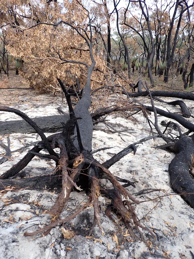
Stapleton Reserve
Stapleton Park Reserve In Spring 2020: An Urban Ark Of Plants Found Nowhere Else
Stealing The Bush: Pittwater's Trees Changes - Some History 
Stokes Point To Taylor's Point: An Ideal Picnic, Camping & Bathing Place 
Stony Range Regional Botanical Garden: Some History On How A Reserve Became An Australian Plant Park
Taylor's Point Public Wharf 2013-2020 History
The Chiltern Track
The Chiltern Trail On The Verge Of Spring 2023 by Kevin Murray and Joe Mills
The 'Newport Loop': Some History 
The Resolute Beach Loop Track At West Head In Ku-Ring-Gai Chase National Park by Kevin Murray
The Top Predator by A Dad from A Pittwater Family of Dog Owners & Dog Lovers
Threatened Species Day 2025 + A few insights into Pittwater's Past + Present Threatened Species 
$378,072 Allocated To Council For Weed Control: Governor Phillip Park Gets a Grant This Time: full details of all 11 sites - Crown Reserves Improvement Fund (CRIF) March 2023
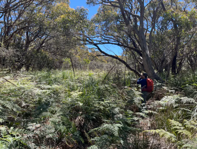
Topham Track Ku-Ring-Gai Chase NP,  August 2022 by Joe Mills and Kevin Murray
Towlers Bay Walking Track by Joe Mills
Trafalgar Square, Newport: A 'Commons' Park Dedicated By Private Landholders - The Green Heart Of This Community
Tranquil Turimetta Beach, April 2022 by Joe Mills
Tree Management Policy Passed
Trial to remove shark nets - NBC - Central Coast - Waverly approached to nominate a beach each
Turimetta Beach Reserve by Joe Mills, Bea Pierce and Lesley
Turimetta Beach Reserve: Old & New Images (by Kevin Murray) + Some History
Turimetta Headland
Turimetta Moods by Joe Mills: June 2023
Turimetta Moods (Week Ending June 23 2023) by Joe Mills
Turimetta Moods: June To July 2023 Pictures by Joe Mills
Turimetta Moods: July Becomes August 2023 by Joe Mills
Turimetta Moods: August Becomes September 2023 ; North Narrabeen - Turimetta - Warriewood - Mona Vale photographs by Joe Mills
Turimetta Moods August 2025 by Joe Mills
Turimetta Moods: Mid-September To Mid-October 2023 by Joe Mills
Turimetta Moods: Late Spring Becomes Summer 2023-2024 by Joe Mills
Turimetta Moods: Warriewood Wetlands Perimeter Walk October 2024 by Joe Mills
Turimetta Moods: November 2024 by Joe Mills

Pittwater's Birds

Attracting Insectivore Birds to Your Garden: DIY Natural Tick Control - small bird insectivores, species like the Silvereye, Spotted Pardalote, Gerygone, Fairywren and Thornbill, feed on ticks. Attracting these birds back into your garden will provide not only a residence for tick eaters but also the delightful moments watching these tiny birds provides.
Aussie Backyard Bird Count 2017: Take part from 23 - 29 October - how many birds live here?
Aussie Backyard Bird Count 2018 - Our Annual 'What Bird Is That?' Week Is Here! - This week the annual Aussie Backyard Bird Count runs from 22-28 October 2018. Pittwater is one of those places fortunate to have birds that thrive because of an Aquatic environment, a tall treed Bush environment and areas set aside for those that dwell closer to the ground, in a sand, scrub or earth environment. To take part all you need is 20 minutes and your favourite outdoor space. Head to the website and register as a Counter today! And if you're a teacher, check out BirdLife Australia's Bird Count curriculum-based lesson plans to get your students (or the whole school!) involved

Australian Predators of the Sky by Penny Olsen - published by National Library of Australia

Australian Raven  Australian Wood Duck Family at Newport

A Week In Pittwater Issue 128   A Week In Pittwater - June 2014 Issue 168

Baby Birds Spring 2015 - Rainbow Lorikeets in our Yard - for Children 

Baby Birds by Lynleigh Greig, Southern Cross Wildlife Care - what do if being chased by a nesting magpie or if you find a baby bird on the ground

Baby Kookaburras in our Backyard: Aussie Bird Count 2016 - October

Balloons Are The Number 1 Marine Debris Risk Of Mortality For Our Seabirds - Feb 2019 Study

Bangalley Mid-Winter   Barrenjoey Birds Bird Antics This Week: December 2016

Bird of the Month February 2019 by Michael Mannington

Birdland Above the Estuary - October 2012  Birds At Our Window   Birds at our Window - Winter 2014  Birdland June 2016

Birdsong Is a Lovesong at This time of The Year - Brown Falcon, Little Wattle Bird, Australian Pied cormorant, Mangrove or Striated Heron, Great Egret, Grey Butcherbird, White-faced Heron 

Bird Songs – poems about our birds by youngsters from yesterdays - for children Bird Week 2015: 19-25 October

Bird Songs For Spring 2016 For Children by Joanne Seve

Birds at Careel Creek this Week - November 2017: includes Bird Count 2017 for Local Birds - BirdLife Australia by postcode

Black Cockatoo photographed in the Narrabeen Catchment Reserves this week by Margaret G Woods - July 2019

Black-Necked Stork, Mycteria Australis, Now Endangered In NSW, Once Visited Pittwater: Breeding Pair shot in 1855

Black Swans on Narrabeen Lagoon - April 2013   Black Swans Pictorial

Blue-faced Honeyeaters Breeding In Pittwater

Brush Turkeys In Suburbia: There's An App For That - Citizen Scientists Called On To Spot Brush Turkeys In Their Backyards
Buff-banded Rail spotted at Careel Creek 22.12.2012: a breeding pair and a fluffy black chick

Cayley & Son - The life and Art of Neville Henry Cayley & Neville William Cayley by Penny Olsen - great new book on the art works on birds of these Australian gentlemen and a few insights from the author herself
Crimson Rosella - + Historical Articles on

Death By 775 Cuts: How Conservation Law Is Failing The Black-Throated Finch - new study 'How to Send a Finch Extinct' now published

Eastern Rosella - and a little more about our progression to protecting our birds instead of exporting them or decimating them.

Endangered Little Tern Fishing at Mona Vale Beach

‘Feather Map of Australia’: Citizen scientists can support the future of Australia's wetland birds: for Birdwatchers, school students and everyone who loves our estuarine and lagoon and wetland birds

First Week of Spring 2014

Fledging - Baby Birds coming to ground: Please try and Keep them close to Parent Birds - Please Put out shallow dishes of water in hot weather

Fledgling Common Koel Adopted by Red Wattlebird -Summer Bird fest 2013  Flegdlings of Summer - January 2012

Flocks of Colour by Penny Olsen - beautiful new Bird Book Celebrates the 'Land of the Parrots'

Friendly Goose at Palm Beach Wharf - Pittwater's Own Mother Goose

Front Page Issue 177  Front Page Issue 185 Front Page Issue 193 - Discarded Fishing Tackle killing shorebirds Front Page Issue 203 - Juvenile Brush Turkey  Front Page Issue 208 - Lyrebird by Marita Macrae Front Page Issue 219  Superb Fairy Wren Female  Front Page Issue 234: National Bird Week October 19-25  and the 2015 the Aussie Back Yard Bird Count: Australia's First Bird Counts - a 115 Year Legacy - with a small insight into our first zoos Front Page Issue 236: Bird Week 2015 Front Page Issue 244: watebirds Front Page Issue 260: White-face Heron at Careel Creek Front Page Issue 283: Pittwater + more birds for Bird Week/Aussie Bird Count  Front Page Issue 284: Pittwater + more birds for Bird Week/Aussie Bird Count Front Page Issue 285: Bird Week 2016  Front Page Issue 331: Spring Visitor Birds Return

G . E. Archer Russell (1881-1960) and His Passion For Avifauna From Narrabeen To Newport 

Glossy Black-Cockatoo Returns To Pittwater by Paul Wheeler Glossy Cockatoos - 6 spotted at Careel Bay February 2018

Grey Butcher Birds of Pittwater

Harry Wolstenholme (June 21, 1868 - October 14, 1930) Ornithologist Of Palm Beach, Bird Man Of Wahroonga 

INGLESIDE LAND RELEASE ON AGAIN BUT MANY CHALLENGES  AHEAD by David Palmer

Issue 60 May 2012 Birdland - Smiles- Beamings -Early -Winter - Blooms

Jayden Walsh’s Northern Beaches Big Year - courtesy Pittwater Natural Heritage Association

John Gould's Extinct and Endangered Mammals of Australia  by Dr. Fred Ford - Between 1850 and 1950 as many mammals disappeared from the Australian continent as had disappeared from the rest of the world between 1600 and 2000! Zoologist Fred Ford provides fascinating, and often poignant, stories of European attitudes and behaviour towards Australia's native fauna and connects these to the animal's fate today in this beautiful new book - our interview with the author

July 2012 Pittwater Environment Snippets; Birds, Sea and Flowerings

Juvenile Sea Eagle at Church Point - for children

King Parrots in Our Front Yard  

Kookaburra Turf Kookaburra Fledglings Summer 2013  Kookaburra Nesting Season by Ray Chappelow  Kookaburra Nest – Babies at 1.5 and 2.5 weeks old by Ray Chappelow  Kookaburra Nest – Babies at 3 and 4 weeks old by Ray Chappelow  Kookaburra Nest – Babies at 5 weeks old by Ray Chappelow Kookaburra and Pittwater Fledglings February 2020 to April 2020

Lion Island's Little Penguins (Fairy Penguins) Get Fireproof Homes - thanks to NSW National Parks and Wildlife Service and the Fix it Sisters Shed

Long-Billed Corella

Lorikeet - Summer 2015 Nectar

Lyre Bird Sings in Local National Park - Flock of Black Cockatoos spotted - June 2019

Magpie's Melodic Melodies - For Children (includes 'The Magpie's Song' by F S Williamson)

Masked Lapwing (Plover) - Reflected

May 2012 Birdland Smiles Beamings Early Winter Blooms 

Mistletoebird At Bayview

Musk Lorikeets In Pittwater: Pittwater Spotted Gum Flower Feast - May 2020

Nankeen Kestrel Feasting at Newport: May 2016

National Bird Week 2014 - Get Involved in the Aussie Backyard Bird Count: National Bird Week 2014 will take place between Monday 20 October and Sunday 26 October, 2014. BirdLife Australia and the Birds in Backyards team have come together to launch this year’s national Bird Week event the Aussie Backyard Bird Count! This is one the whole family can do together and become citizen scientists...

National Bird Week October 19-25  and the 2015 the Aussie Back Yard Bird Count: Australia's First Bird Counts - a 115 Year Legacy - with a small insight into our first zoos

Native Duck Hunting Season Opens in Tasmania and Victoria March 2018: hundreds of thousands of endangered birds being killed - 'legally'!

Nature 2015 Review Earth Air Water Stone

New Family of Barking Owls Seen in Bayview - Church Point by Pittwater Council

Noisy Visitors by Marita Macrae of PNHA 

Pittwater Becalmed  Pittwater Birds in Careel Creek Spring 2018   Pittwater Waterbirds Spring 2011  Pittwater Waterbirds - A Celebration for World Oceans Day 2015

Pittwater's Little Penguin Colony: The Saving of the Fairies of Lion Island Commenced 65 Years Ago this Year - 2019

Pittwater's Mother Nature for Mother's Day 2019

Pittwater's Waterhens: Some Notes - Narrabeen Creek Bird Gathering: Curious Juvenile Swamp Hen On Warriewood Boardwalk + Dusky Moorhens + Buff Banded Rails In Careel Creek

Plastic in 99 percent of seabirds by 2050 by CSIRO

Plover Appreciation Day September 16th 2015

Powerful and Precious by Lynleigh Grieg

Red Wattlebird Song - November 2012

Restoring The Diamond: every single drop. A Reason to Keep Dogs and Cats in at Night. 

Return Of Australasian Figbird Pair: A Reason To Keep The Trees - Aussie Bird Count 2023 (16–22 October) You can get involved here: aussiebirdcount.org.au

Salt Air Creatures Feb.2013

Scaly-breasted Lorikeet

Sea Birds off the Pittwater Coast: Albatross, Gannet, Skau + Australian Poets 1849, 1898 and 1930, 1932

Sea Eagle Juvenile at Church Point

Seagulls at Narrabeen Lagoon

Seen but Not Heard: Lilian Medland's Birds - Christobel Mattingley - one of Australia's premier Ornithological illustrators was a Queenscliff lady - 53 of her previously unpublished works have now been made available through the auspices of the National Library of Australia in a beautiful new book

7 Little Ducklings: Just Keep Paddling - Australian Wood Duck family take over local pool by Peta Wise 

Shag on a North Avalon Rock -  Seabirds for World Oceans Day 2012

Short-tailed Shearwaters Spring Migration 2013 

South-West North-East Issue 176 Pictorial

Spring 2012 - Birds are Splashing - Bees are Buzzing

Spring Becomes Summer 2014- Royal Spoonbill Pair at Careel Creek

Spring Notes 2018 - Royal Spoonbill in Careel Creek

Station Beach Off Leash Dog Area Proposal Ignores Current Uses Of Area, Environment, Long-Term Fauna Residents, Lack Of Safe Parking and Clearly Stated Intentions Of Proponents have your say until February 28, 2019

Summer 2013 BirdFest - Brown Thornbill  Summer 2013 BirdFest- Canoodlers and getting Wet to Cool off  Summer 2013 Bird Fest - Little Black Cormorant   Summer 2013 BirdFest - Magpie Lark

Summer BirdFest 2026: Play antics of New Locals - Blue-faced Honeyeaters Breeding In Pittwater

The Mopoke or Tawny Frogmouth For Children - A little bit about these birds, an Australian Mopoke Fairy Story from 91 years ago, some poems and more - photo by Adrian Boddy
Winter Bird Party by Joanne Seve