Environment News: January 2026

January 1 - 31, 2026: Issue 650

Community Concern As Another Tree Up for Destruction by the Council - Doubling of prior Bassett Street Mona Vale DA proposal under NSW government SSD's provides stark illustration of impact on local environment of laws written 'for developers' - Community Objections Being silenced or Ignored

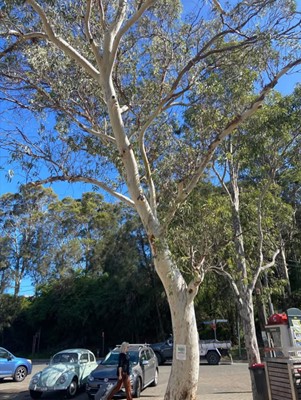
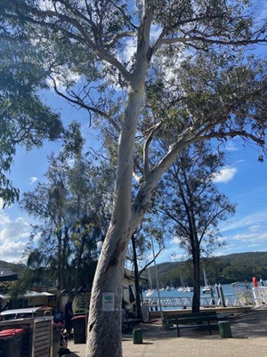
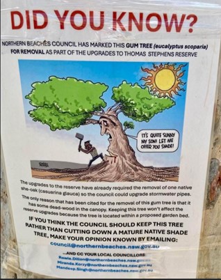
Pittwater residents are concerned about the Eucalyptus Scoparia, currently under consideration for removal at Church Point’s Thomas Stephens Reserve, by the Northern Beaches Council. Notice of this removal was made available just before Christmas. The many community objections are a push back against the continuing removal of trees by the council in Pittwater and none being planted to replace these.

Staff provided the following response before Christmas: 

"The landscaping component of the Thomas Stephens Reserve project is scheduled to commence in February 2026. At that stage, once pavers and associated infrastructure are removed, Council will undertake further investigations into the health of the tree. The outcome of these investigations will inform the appropriate course of action."

Eucalyptus scoparia (Wallangarra White Gum) is known to have issues with branch failure and, while not cited among the most notorious "widowmakers" like E. camaldulensis (Red River Gum), they are susceptible to significant structural issues in urban settings, especially if their root system has been compromised by encroachments. 

However, residents are asking why - given the arborist’s report does not identify any significant risk from it - is yet another tree that is food and habitat for wildlife, and shade for humans, slated for killing by this council. 

Residents who have lodged a complaint or protest against its removal state they have been assured by councillors nothing would happen to it over January - but it's almost February and with the council's very poor record on looking after the Pittwater environment, and the loss of trees on every street and every playing field through the council removing them continuing, and no replacements being planted despite a 'tree plan' being passed that states in black and white they will be, the push back against south of Narrabeen Bridge 'town planning' persists in Pittwater - even for Notices made when it is assumed locals have 'clocked off' for a break and may not.... notice. 

Residents point out with each of these incidences the difference between the Warringah-style council, refashioned into a 'Northern Beaches Council', and their own Pittwater Council grows. 

They are calling on the still in place Pittwater Council LEP and DCP to be observed - just as the council is spending Pittwater ratepayers money to defend the same in the former Warringah council area.

See: Council Appeal on Oxford Falls Seniors DA Successful: Errors on Questions of Law Grounds

And to cease passing an environmental and social destruction of Pittwater- which many state is actual 'policy' under the NBC.

See: Killing of Ruskin Rowe Heritage Listed Tree 'authoritarian' or Council proposal to turn Boondah Reserve into a Sports Precinct: Consult feedback closes Nov. 23 or  Northern Beaches Council recommends allowing dogs offleash on Mona Vale Beach or Community Concerned Over the Increase of Plastic Products Being Used by the Northern Beaches Council for Installations in Pittwater's Environment

One Mona Vale resident, Richard W., stated:

''I am astonished that council is proposing to remove the entire tree pictured below purportedly because it has dead wood in its canopy.

Why not simply prune the dead wood and otherwise leave the tree as it is?

Would you please register my objection to this senseless destruction.'' 

The incessant removal of mature hollow bearing trees is showing up in birds that require these now being homeless, and without shelter during the rain. Seedlings and small trees, even fast growing species, are no replacements for trees that have taken 50-100 years and more to mature to where they provide homes for wildlife:

homeless soaked Rainbow lorikeets, January 17-18 2026, Careel Bay

Community Being Silenced

Anna Maria Monticelli, Secretary of Protect Pittwater, applied and was denied 3 minutes speaking at the last Public Forum the Northern Beaches Council held as part of council meetings in December 2025. Her Address articulates these ongoing concerns of the Pittwater community, many of whom have dubbed the NBC just another version of Warringah Council, still pulling millions out of Pittwater to spend in Warringah while laying down concrete where it's not wanted, putting in park benches on corners from which to view traffic, and plastic grass into known flood zones - just to up the kinds of pollution flowing into the estuary or onto the beaches every time it rains - and even as these materials are being installed. 

In recent months residents have seen both the Public Forum and Public Address opportunities being excised by members of political parties or lobbyist groups to express their opinions, and were becoming increasingly frustrated these are being used in this way.

The Public Forum provided an opportunity for residents to speak on any matter. The Public Address provided an opportunity for residents to speak on Items listed in the Agenda of council meetings, limited to two for and two against. 

Under new Code Meeting practices passed by the council at the December 2025 meeting both the public forum and public address have been removed from council meetings. The NSW Office of Local Government's Model Code of Meeting Practice for Local Councils in NSW for 2025 states these can still be held directly before a council meeting.

The document reiterates:

4 Public forums
4.1 The council may hold a public forum prior to meetings of the council and committees of the council for the purpose of hearing oral submissions from members of the public on items of business to be considered at the meeting. Public forums may also be held prior to meetings of other committees of the council.
4.2 The council may determine the rules under which public forums are to be conducted and when they are to be held.
4.3 The provisions of this code requiring the livestreaming of meetings also apply to public forums.

In the governments' FAQ's it is stated:
'The public forum provisions are now mandatory but leave it to councils to determine whether to hold public forums before council and committee meetings'

The council interpreted this as meaning for the Public Address - ''public forums may not be held as part of the council meeting for hearing submissions on items of business on the agenda for the meeting'' - and that the Public Forum aspect, to speak on any matter, is now gone.

Under Appendix 1 of the council's draft document on Public Forum lists, among its items, 'Speakers may not make defamatory statements' (which had been a part of this platform in the last few ordinary council meetings), but no provision for residents being allowed to own this platform had been made.

Appendix 1 of the NBCDraft document listed, among other items:
A1.6 To speak at a public forum, a person must first make an application to the Council in the approved form. Applications to speak open when the business papers are published and must be received by 5pm on the business day prior to the date on which the public forum is to be held. Applications must identify the item of business on the agenda of the Council meeting the person wishes to speak on, and whether they wish to speak ‘for’ or ‘against’ the item.
Note: The Chief Executive Officer or their delegate may refuse an application to speak at a public forum where the application does not meet the outlined requirements or there is a genuine and demonstrable concern relating to the applicant or their dealings with the Council or their intentions.
A1.7 To speak at a public forum, a speaker must attend in person.
A1.8 Legal representatives acting on behalf of others must identify their status as a legal representative when applying to speak.
A1.11 Speakers must not digress from the item of business on which they applied to speak. If a speaker digresses to irrelevant matters, the chairperson is to direct the speaker not to do so. If the speaker fails to observe a direction from the chairperson, the chairperson may immediately require the person to stop speaking and they will not be further heard.
A1.12 A public forum should not be used to raise questions or complaints. Such matters should be forwarded in writing to the council where they will be responded to by appropriate council officers.

In August 2024 the Northern Beaches Council was proposing to cut the amount of time residents and councillors will be allowed to speak at meetings and to ban photography anywhere near them. Then it was proposed to cut speakers’ time during public forums and addresses from three to two minutes. These had once been 5 minutes but had been reduced already.

Similarly, all councillors were to be limited to speeches of two minutes during the meetings, unless they had proposed a Motion. A ban on photography during meetings would also be extended to before and after, “whilst in the vicinity of the meeting location”.

“Cutting speeches to two minutes might be a great relief for some, but the loss of those 150 words might prevent someone from explaining the intricacies of a complicated issue or describing a particularly pertinent example.'' Cr. Korzy said in 2024

“Meetings often run from 6pm to 11.30pm, with many of us arriving home well after midnight, and I would dearly love to see them shorter. We’re all aware they deteriorate after about 9pm with participants getting tired, niggling at each other across the floor and losing concentration. 

“However, the proposed solution, based on the idea of making meetings more efficient, will add to the slow curtailment of democratic debate.

“The root of the problem is that the council unavoidably has too much business on its agenda, due to its size since the forced amalgamation, and some councillors’ antics delay progress through the agenda. The open-ended ban on photography is also an incursion on democracy, and a nonsense when the council itself screens the meetings online.  Councillors and members of the community would be prevented from focusing the lens on those attending, even outside the chamber, which would limit anyone snapping photos showing numbers of supporters for any issue.”  

Although some Councillors have been calling for years for two council meetings each month in order to adequately deal with every Item listed rather than seeing these bounced over to the following month - especially those Items of import to the community - the once a month meeting and the bouncing forward persists. 

At the December 16 2025 council meeting it was resolved to:

''Establish a monthly community engagement forum, separate from the public forum referred to in clause 4 of the Code of Meeting Practice, to be held on the same evening as that public forum, for Councillors to hear from the members of the public on items not on the Council meeting agenda, on a trial basis for 6 months.''

The council also voted to 'Delete the following clauses: i. 11.5, 11.6, 11.7 and 11.8' and 'Note its opinion that the amendments to the draft Code are not substantial and it may adopt the amended draft Code without public exhibition as its code of meeting practice.'

The changes commenced as of January 1 2026.

A Notice of Motion to Rescind Council's Resolution made on 16 December 2025 in respect of Item 9.2 Outcome of Public Exhibition - Draft Code of Meeting Practice has since been lodged for the February 17 2026 council meeting - the first of a whole eleven for the year 2026.

Ms Monticelli's Address, unheard anywhere else, is:- 

What the Northern Beaches Council has never understood is that their role is to represent us, not shut us up. 

The council’s “have your say” campaigns amount to little more than PR exercises. They disregard genuine community input, patronise residents, and fuel frustration and anger.

Local democracy only works when communities have a genuine voice. Pittwater’s voice has been politically silenced since amalgamation.

We have 3 councillors in the Northern Beaches Council out of 15.

When the vote is 12 against 3, Pittwater loses every time.

When the vote is 12 against 3, responsible development rules for Pittwater loses every time. 

When the vote is 12 against 3, our environment  loses every time. 

When the vote is 12 against 3 a community’s confidence in democracy  loses every time. 

Simply put - Pittwater always has a minority voice.

The 12–3 vote structure reinforces growing calls for de-amalgamation with many residents saying they no longer feel represented by the Northern Beaches Council. 

What we have is not meaningful representation. It leaves people feeling side-lined in decisions that directly affect them. Pittwater council had 9 councillors all living in Pittwater.

The Pittwater community is not seeking special treatment: what we are seeking is appropriate recognition that our area is ecologically and geographically unique and cannot be governed by the same metropolitan development controls as other parts of Sydney. 

The current blanket approach to development which circumvent local environmental limits,  threatens our environment, our lifestyle and our safety. In particular the danger of pushing more people into an already crowded and confined fire zone.

A recent report co-authored by the former NSW fire commissioner, Greg Mullins, warns that what happened in the 2025 Los Angeles fires, will happen here. The report’s findings were a “wake up call”, he said.” “If you live in suburbia and think bushfires don’t concern you, think again.”

Parts of Sydney, like the Northern Beaches, Penrith and the Blue Mountains, were a “ticking timebomb” he said, with massive fuel loads built-up after years of rain.

“I know it’ll scare people,” he said. “But I hope they get past that and [say] we have to take action.”

Pittwater is on a peninsular.  It has one main road in and one road out with narrow winding streets already congested with all the current ongoing-development. 

It is inevitable congestion will only get worse, particularly when developers start targeting all our R2 and R3 zonings across Pittwater (which permits development consistent with residential zones right across Sydney.) Unfortunately NBC does not give proper consideration to the Pittwater Wards’ different situation.

And  If Pittwater is governed like the rest of Sydney, it will be developed like Sydney.

Developers will flock here because Pittwater is a place where they can maximise their profits. Pittwater is environmentally unique and  it must be protected and governed differently.

When the experts tell us terrible fires will happen here,  we cannot blindly ignore them despite what politicians and urban planners say. Forcing more people into a high risk bush fire zone is a recipe for disaster. 

If an expert such as Mr. Mullins is correct, one day soon, Pittwater will experience an inferno unprecedented in its history. Cars will be gridlocked on the Bends and on Barrenjoey Road. Lives will be lost and property destroyed. Fire trucks and emergency services will be immobilised in traffic. 

We must stop overdevelopment that threatens public safety and start paying attention to the warning signs around us. The evidence is already here.

We need our voices heard:

  • We need to fight the State government planning rules that endanger lives, property and our environment.
  • We need to take control and  leave the Northern Beaches Council, re-instate a Pittwater Council. 
  • We need ACTION NOW before it’s too late. 
  • Protecting Pittwater with its own council is not radical—it’s responsible.

Anna Maria Monticelli
Secretary Protect Pittwater

State Government's SSD's Have Developers Doubling Proposals

Ms Monticelli's Address resonates even further with Pittwater residents in view of the prior state government and council designation for places such as Mona Vale, which has only been made more stark by the current state government's SSD designation for half the suburb.

One example is the change for a September 2022 decision by the previous Coalition Government appointed Sydney North Planning Panel to approve a rezoning review request made that sought to amend the Pittwater Local Environmental Plan 2014 to:

  • Rezone properties 159-167 Darley Street West, Mona Vale from R2 Low Density Residential to R3 Medium Density Residential to facilitate the redevelopment of these sites for medium density residential housing, and
  • Amend clause 4.5A of the PLEP 2014 to remove its applicability to the subject site to provide a diversity and mix of housing.
That 2022 planning proposal change was for 41 dwellings on these 5 lots, which equated to 8 dwellings per block where once there was 1. 

Under the current state government's State Significant Development (SSD) changes a new proposal for the same has now been put forward for 82 dwellings, doubling the impact, and razing the streetscape and blocks of all trees in a known flood zone.

Those living in similar developments further up the hill, with underground carparks, state they have had several insurance claims since their builds' completion, as there have been flooding problems and ongoing subterranean moisture. In fact, everywhere such developments have been allowed, on known water courses, over old creeks and swamplands, those buying into them soon find they have bought something they will pay to repair for the term of their living there. 
On 15 April 2025, the amendment to the Pittwater LEP 2014 was finalised, which involved the following key changes to the site’s planning controls:
  • Rezone the site from Zone R2 Low Density Residential to Zone R3 Medium Density Residential.
  • Include a clause under the Pittwater LEP 2014 to require a 5% affordable housing rate to apply to the total gross floor area.
  • Include the site on the Biodiversity Map and for clause 7.6 biodiversity of the Pittwater LEP 2014 to apply.
  • Remove the site from the Minimum Lot Size Map consistent with all land zoned R3 Medium Density Residential in the Pittwater LEP 2014. 
Following LEP finalisation, it was noted that the final LEP Amendment did not achieve the underlying objectives or intent of the site-specific rezoning, which was to abolish the restriction of dwelling density control applicable under Clause 4.5A of the Pittwater LEP for all R3 zoned land. Colliers Urban Planning (formerly Ethos Urban), on behalf of the Applicant, made representations to DPHI in May 2025 raising concern for the continued application of this dwelling density control, and its effects on the application of applying Chapter 6 (Low and Mid Rise Housing) under the State Environmental Planning Policy (Housing) 2021 (Housing SEPP).

On 5 September 2025, amendments to the Pittwater LEP 2014 were made and included an amendment to Clause 4.5A(3) to identify that this clause no longer applies to the subject site. 

Under the Northern Beaches Section 7.12 Contributions Plan 2024; Contributions will be provided in accordance with the Northern Beaches Section 7.12 Contributions Plan 2024, which will apply a levy of 1% of the total EDC as it is more than $200,00.

The SSD will also become part of Northern Beaches Council’s Affordable Housing Contributions Scheme; In addition to the Section 7.12 levy, contributions will be provided in accordance with Council’s Affordable Housing Contributions Scheme, which will apply a rate of $19,658 per square metre. 
 
The EIS states '26 trees are being retained on site and 58 trees are proposed to be removed; however, these will be appropriately supplemented by the planting of 84 new trees in their place, equating to a net increase of 26 trees on the site.'

However, many 'new' trees planted to gain passage of a DA are then ripped out soon after being counted - and as residents continue to point out, you cannot replace an established old tree with a new one and think they are the same. 

Regarding being in a known waterflow zone, the proponents state:
''The proposal adequately manages the overland flow path on the site and associated flooding risks. On-site stormwater detention and treatment systems will be designed in accordance with the relevant standards.'

The Total Development Cost (Plus GST) for Non-SSD/SSI is tabled as being $ 104,891,540.00.

Both the council and state governments continue to approve such DA's, disregarding the knowledge and research that informed those Local Environment and Development Control Plans and signalling these will all be approved no matter how many objections are lodged by those with lived experience of these places. 

John David, Convenor of newly formed residents group, SOS Save Our Suburb Mona Vale, points out: 

''On Tuesday January 20 2026 the EIS for the SSD proposal in Darley Street West was made available and submissions can be lodged with the State Government.''

We get only 14 days from today until Tuesday 3rd of February 2026 to 
  • read the proposal, 
  • make a considered assessment of our objections (or support),
  • and write & submit our views.
This short period includes the Australia Day holiday weekend and in my view is a further cynical attempt by both developer and State Government to sideline the community to as much as possible.'' John said, explaining further:
  • Letters advising "the community" went out to neighbours only.
  • The entire proposal is 2361 pages long.
The State Government has telegraphed theses changes to developers for over a year before they became law.
  • the developer gets a year to prepare their proposal;
  • the State Government gets 270 days (the average assessment period) to do their due diligence;
  • the community gets 14 days to submit their views!
''There is nothing about this process that suggests the State Government or the developers have any wish to dignify the rights of residents of this suburb with anything apart from a passing interest. We are invisible and unimportant in their minds.''

''The cynical exercise of putting this brief "exhibition period" around the Australia Day holiday is no accident. It demonstrates what little respect the developer AND the State Government have for your concern. Do not let them bully you.'' Mr. David said


The SSD is now for a 5-storey with 3 levels of underground carparking, forcing a dam of concrete into the earth through which waters move and in which pipes containing old creeks have already been placed. 

Why settle to make $42 million when you can make $100+ million?

To find out more about SOS Mona Vale visit: www.sosmonavale.com.au

The destruction of Pittwater, tree by tree by council and state government, in flood zone by flood zone, continues. 
Residents state that is: ''All for the benefit of profiteers who will be long gone when the community picks up the tab for increased costs to mitigate, through rate rises equating currently to an extra 16 million dollars, what is already occurring in these places.''

The sentiment is that 100 years after the first 1920's a 'for developers policy' of razing the North Narrabeen watersheds, all the way along the Barrenjoey peninsula, and a total disregard for the problems created, will now also place humans in jeopardy, or at best, reduce their standard of living, to live in a place with shaded cooler paths and pristine waters, to zero.

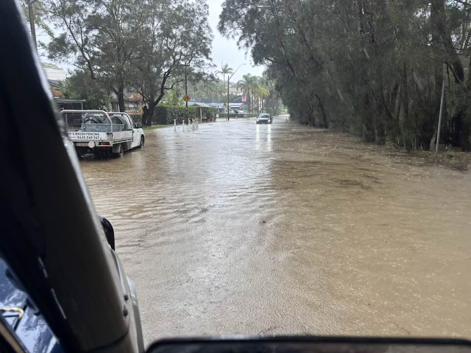
Flooding across Pittwater, including Mona Vale and Bayview over January 17-18 2026, would indicate the build-up of hard structures on the surface, and underground construction of concrete carparks that are 'dams' on the flow of water through the earth or along the historical creek channels, are effectively already exacerbating a landscape not meant for these sorts of developments.


NSW SES Warringah / Pittwater Unit members clearing a blocked drain on Pittwater road at Mona Vale which was making the flooding worse. Photo: NSW SES Warringah / Pittwater Unit via FB

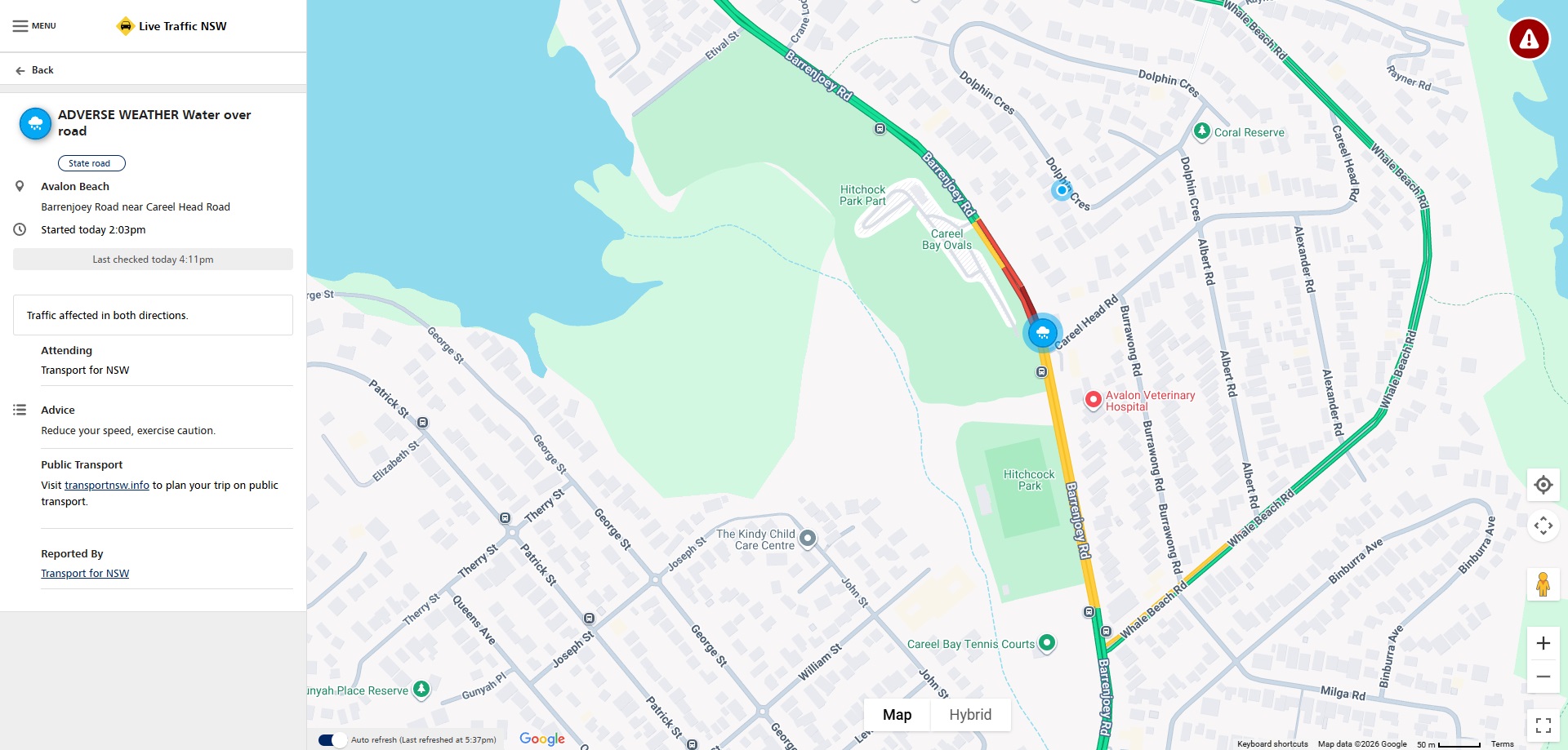
At Careel Head Road, North Avalon, where the council spent so much of a government grant to put in a pavement on plans for the same that it was decided not to put in the guttering along a whole section, or the originally designed retaining walls leading into the intersection.

The road was flooding on January17-18 2026, effectively blocking any safe passage for emergency services needed further north. This has been occurring at this intersection since time immemorial, excepting in recent years this has been happening more frequently and flooding higher and higher and further each time, with the whole flat stretch south and north of Careel Head road, to Etival street and beyond, 1000 metres in length, now regularly being covered in water each time it rains. 


July 2022: Corner of Barrenjoey Road and Careel Head road floods in rains, with some drivers crossing double lines on that corner and into lane of southbound vehicles

Careel Head-Barrenjoey Road section, January 17 2026. Photo: Adam L'Green/FB

At this junction it took almost a year to fix just one of the drains. 

At 8am on August 2nd 2022 a Council worker erected these barriers around one of the drains. The Council person, with an attitude where they were apparently deigning to reply, stated to the Pittwater Online employee who spotted the barricades going up that ''the work would be attended to as soon as someone was able to do the work''.


Saturday June 3, 2023 - barricades still in place around this still unfixed drain

There were a few more floods along this section in between that lapse of almost 12 months and several since.

As residents of Pittwater begin to eye May 2026, 10 years since 'Warringah council' was forcibly imposed on them once more by the previous Coalition government and through the campaign of the then Warringah council to be in charge of everything, and the current state government's apparent stone-deafness to the impacts their 'housing policy' will cause, the appetite for Pittwater Council to be returned, and for representation that is For, About and BY Pittwater, has grown, not diminished.

Related: 
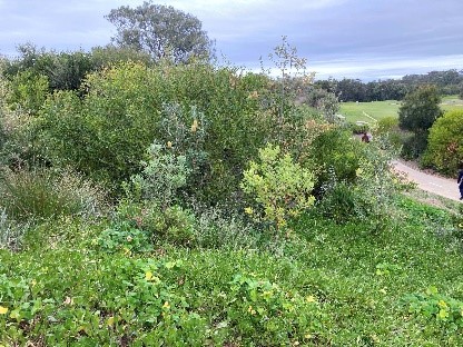
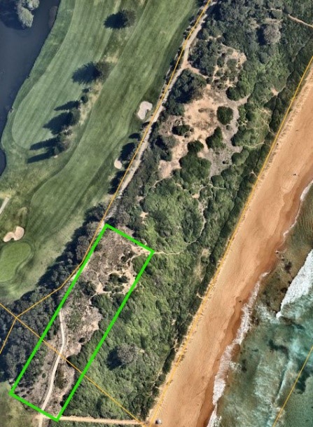
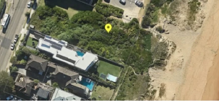
159-167 Darley Street West, DA is for 5-storey buildings with 3-storyes of carparking under them - he trees seen here, holding the earth in place, will be removed

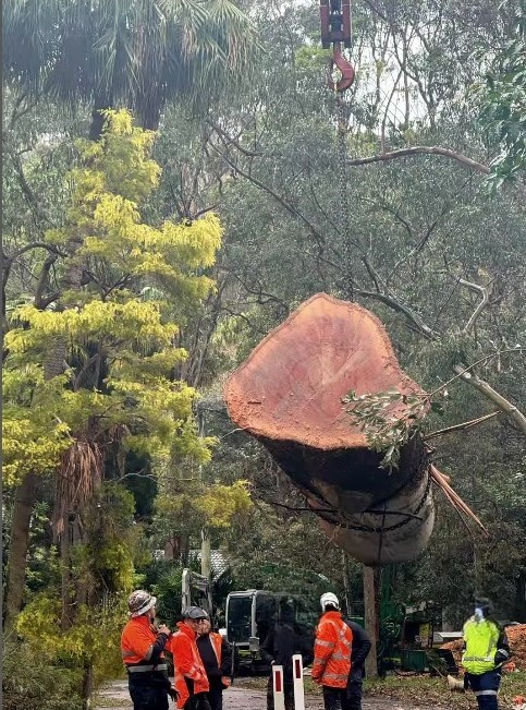
screenshot from CK video of the Ruskin Rowe gum tree trunk - killed by council decree


VOYAGE AROUND BANGALLEY

By Pittwater Pathways, John  Illingsworth, published January 24 2025

John says: ''Bangalley Head is to the immediate north of Sydney, Australia, between Avalon Beach and Whale Beach. The first headland in this short  film is actually Avalon Head aka Indian Head in times past. In company with Lynette Illingsworth, Marita Macrae delivered a simple but powerful message about what we have to do to save this savage beauty - that it is not enough to simply treasure our wild places - we must also nurture them, as did those that came before us for millennia. 

We are all on a voyage - Lynette recently completed hers. She and Marita show by example one way we might best complete our own.''

Mona Vale Dunes bushcare group: 2026 Dates

What’s Happening? Mona Vale Dunes Bushcare group catch-up. 

In 2026 our usual work mornings will be the second Saturday and third Thursday of each month. You can come to either or both. 

We are maintaining an area south of Golf Avenue. This was cleared of dense lantana, green cestrum and ground Asparagus in 2019-2020. 600 tubestock were planted in June 2021, and natural regeneration is ongoing. 

Photos: The site In November 2019, chainsaws at the ready. In July 2025, look at the difference - coastal dune vegetation instead of dense weeds. But maintenance continues and bushcarers are on the job. Can you join us?

(access to this southern of MV Dunes  - parking near Mona Vale Headland reserve, or walk from Golf Ave.) 

For comparison, see this image of MV dunes in 1969!, taken from atop the home units at the end of Golf Avenue. 

2026 Dates

Bangalley Headland WPA Bushcare 2026

Watch out for PNHA signs telling you about bush regeneration and our local environment. This is one of many coming up.

Oil-Gas Exploration in Southern Seas reopened by Albanese Government

The Australian Federal Government have reopened 2.5 million hectares of Victorian and Tasmanian waters for oil and gas exploration. This latest release includes 5 exploration titles, stretching across some of Australia's most ecologically and culturally significant waters.

Your voice can help make a difference.

Join Surfrider's (@surfrideraus) Save the Southern Sea campaign as we fight to protect the coastal communities and marine ecosystems of the Southern Ocean. 

Head to the link https://southernsea.givee.app/ to use their simple letter writing tool to make a submission, it's quick and easy to have your say.

Public consultation on the proposed exploration closes February 6th.

Thank you

Surfrider Australia

The $3 billion plan to prevent debris balls on Sydney beaches

On Friday January 16 2026 the NSW Government announced it is undertaking one of the largest wastewater infrastructure upgrade programs in recent history to support the fast-growing communities in Sydney’s south west and help protect the city’s famous beaches.

Manly to Barrenjoey peninsula residents will recall these were washing up on local beaches in January 2025.

See: Ball shaped debris washes up on Local Beaches: Call for Sydney Water to 'Come Clean' on How much Sewerage is leaking into environment

The Malabar System Investment Program, estimated at $3 billion over the next 10 years, will reduce the volume of wastewater that needs to be treated and discharged via the Malabar deep ocean outfall.

The Malabar Wastewater Treatment System was identified as the likely source of debris balls that washed up on beaches across Sydney, the South Coast and Central Coast in late 2024 and early 2025.

It currently services almost two million people between Fairfield, Campbelltown and Liverpool in the West to Malabar in the east, making it one of the largest wastewater systems in Australia.

Staged upgrades over the coming decade will improve the performance of the Malabar system to support population growth in Sydney’s south west and reduce the likelihood of debris balls forming again.

The program will be delivered across key facilities in the Malabar system, including Glenfield, Liverpool and Fairfield Water Resource Recovery Facilities (WRRFs).

For the first stage of the multi-billion program, Sydney Water is partnering with the Malabar System Alliance (Acciona Construction, Acciona Agua, SMEC) to deliver major upgrades to the Glenfield and Liverpool WRRFs.

Work will include refurbishing and expanding primary treatment processes and a new secondary treatment process at Liverpool WRRF, with on-site works to begin in coming months.

In the short-term, Sydney Water is continuing to work with the NSW Environment Protection Authority (EPA) and the independent Wastewater Expert Panel on limiting further debris balls incidents.

Sydney Water has increased cleaning and inspection of ocean outfall screens, is tightening trade-waste controls for high-risk customers, and is expanding its fats, oils and grease education campaign to reduce problematic material from entering the network.

Minister for Water Rose Jackson said:

“Sydney is a rapidly growing city and no one wants to see debris balls washing up on our beautiful beaches again – but the truth is our wastewater system needs an upgrade to keep pace with the population.

“For too long, a lack of investment in essential infrastructure in Western Sydney has been a handbrake on our housing goals. We can’t undo that overnight, but we’re getting on with the job of clearing this backlog.

“This is a major plan to deliver critical wastewater system upgrades in a sensible, staged way, ensuring that major investments are funded over time and Sydney Water users don’t face sudden bill shock.

“Our government is laser-focused on delivering the critical infrastructure our city needs to continue to grow, without privatising our essential assets.”

Sydney Water CEO Darren Cleary said:

“Appointing the Malabar System Alliance is a significant step towards improving the long-term performance and resilience of the critical wastewater asset and reducing the increasing strain on the ageing coastal plant.

“We understand the seriousness of recent debris ball incidents and the need to ensure our network is equipped for Sydney’s growing population.

“This program of works is a clear demonstration of our commitment to building a more resilient system over the coming decade and to protecting our beaches, which are so important to Sydney’s way of life.”

community invited to have a say on recreational opportunities In Great Koala National Park

On January 16 the NSW Government announced it is seeking community input to shape recreational opportunities in the proposed Great Koala National Park on the NSW Mid North Coast.

The Minns Labor Government is delivering on an election promise to create a Great Koala National Park, which will provide habitat for more than 100 threatened species, including more than 12,000 koalas and 36,000 greater gliders.

In addition to boosting conservation, the park will also create opportunities for better visitor experiences and recreation, boosting tourism and local economies.

An online survey is now open on the NSW Have Your Say website to seek feedback on current use of the State forests and reserves within the planned area of the park. We also want to hear from people who haven’t been to the region but might like to in the future.

The survey complements ongoing wider consultation with community groups who have so far provided more than 300 responses on what matters most to them when they visit these areas.

Input from 4WD clubs, mountain biking clubs, hiking/bushwalking and trail runners’ clubs, horse riding and trail riding clubs, archery and gun clubs, sporting car clubs, local government, environment groups and Aboriginal communities is already feeding into the planning for future management.

The overarching park will comprise individual reserves, which will enable a range of different recreational activities. While legislation determines what activities are permissible in each reserve category, we are looking to build the Great Koala National Park as a place where conservation is balanced with the community’s recreational needs.

The Have Your Say survey is open from 7am today until Sunday, 1 March and is available online: www.haveyoursay.nsw.gov.au/great-koala-national-park.

Acting Minister for the Environment, Steve Whan said:

“The Great Koala National Park will protect more than 100 threatened species, but it’s not just about conservation. The park will be a recreational hotspot for locals and visitors alike.

“We want to hear from people who use and relax in the footprint of the forests and surrounding landscapes that make up the park.”

Minister for Jobs and Tourism, Steve Kamper said:

“We want the Great Koala National Park to be at the top of the must-see list for visitors to NSW and Australia.

“This major eco-tourism hub and unique NSW experience will attract domestic and international visitors all year round, which is a key component of our new Visitor Economy Strategy, while boosting local economies and creating jobs.”

Minister for the North Coast, Janelle Saffin said:

“The Great Koala National Park is an election commitment, and we want the community right at the centre of shaping what it becomes. Locals know this landscape best, and their ideas will help create a park people feel real ownership of and want to use.

“Done well, this park will also be a major tourism drawcard – supporting local businesses, creating jobs and delivering long-term economic benefits for communities right across the North Coast.”

Waterbirds return this year, but amid long-term decline: aerial survey

December 15, 2025 by UNSW's Melissa Lyne

The 2025 UNSW aerial waterbird survey shows waterbird numbers, breeding activity and wetland habitat areas remain in significant long-term decline.

New data released today from one of the world’s longest-running wildlife surveys show Australia’s waterbird population made a partial return after last year’s steep drop, but numbers remain well below historic levels.

See: Eastern Australian Waterbird Aerial Survey - October 2025 - Annual Summary Report. J.L. Porter1,2, R.T. Kingsford2, R. Francis2, K. Brandis2, A. Ahern2 ,Y. Tidou2 & D. Simpson2, Department of Climate Change, Energy the Environment & Water (NSW)1, Centre for Ecosystem Science, School of Biological, Earth and Environmental Sciences, UNSW Sydney

Researchers conducting the annual waterbird survey – led by UNSW’s Centre for Ecosystem Science with the NSW Department of Climate Change, Energy, the Environment and Water (DCCEEW) and other state agencies – counted 375,419 birds across a third of the continent this year.

The number is an improvement on 2024’s 287,231 birds, but still far short of the 579,641 birds recorded in 2023. The survey recorded no mass mortality events, which usually signal outbreaks of avian influenza.

This year ranks as the 12th highest for total bird numbers since the survey began in 1983 – and the data show the broader picture remains troubling.

“The total abundance of waterbirds, the number of species breeding and wetland habitat areas continue to show significant long-term decline,” says Scientia Professor Richard Kingsford, Director of the Centre for Ecosystem Science, who leads the survey program.

The survey took place from October to the first week of November 2025, with observations taken from a light plane around 50 metres above water, across the area from Northern Queensland down to the south of Melbourne.

“There were up to 2000 wetlands surveyed,” Prof. Kingsford says. “We had two observers on either side of the plane each day. Their counts are brought together for each wetland.

“We count and identify more than 70 different species of waterbirds.”

Both ends of extreme weather

Wetland habitat area is a major driver of waterbird abundance, breeding and diversity. Climate change, river regulation and water extraction have resulted in ongoing long-term habitat declines – particularly in the Murray-Darling Basin.

The survey results capture a country experiencing more volatile and unpredictable weather as global temperatures climb.

“We had some significant river flow and flooding events this year, with extreme rainfall in southwestern and western Queensland,” Prof. Kingsford says.

“This caused major floods that reached Lake Eyre and became a one-in-500-year severe flooding event on the mid north coast of New South Wales,” he says.

“A lot of the waterbirds have gone up in that part of the world, right out in the desert. They're some of the most stunning parts of Australia and long may they continue to experience the natural booms and busts."

“But, at the same time, we also saw drier conditions persist across parts of southeastern Australia.”

The mixed picture aligns with broader climate records. The world is on track for one of its hottest years on record, amid 15 consecutive months of record global surface temperatures from mid–2023 to mid–2024. And the Bureau of Meteorology recorded a continued shift towards drier conditions across southern Australia, especially from April to October.

This variability carried through to rivers and wetlands: the intense flooding in parts of Queensland and north-eastern NSW contrasted with reduced river flows in western Victoria and South Australia.

Murray–Darling Basin dams, or storages, also dropped to 66% full, down from 77% in 2024 and 92% in 2023.

Birds drawn to refreshed waters

While wetland habitat areas are in long-term decline, the wetland area index rose this year to 334,324 hectares, up from 122,283 hectares in 2024.

Much of this habitat came from major inland systems. Kati Thanda–Lake Eyre, Cooper Creek, Lake Yamma Yamma and the Diamantina floodplain together accounted for 51% of all wetland areas surveyed.

But these expansive wetlands only supported about 4% of the total waterbirds counted.

The most bird numbers were instead recorded at temporary saline desert wetlands – Lakes Mumbleberry and Torquinie in South Australia and Lake Galilee in Queensland. Together, these held more than 99,000 birds – nearly a quarter of this year’s total.

Breeding remains low

Despite the overall increase in abundance, the survey showed a continued long-term decline of breeding levels.

“We had a bounce in numbers after solid breeding in the flood years of 2021 and 2022,” Prof. Kingsford says. “But now numbers are below the long-term average, with little breeding happening in 2023, 2024 and now, 2025.”

The breeding index of nests plus broods rose to 1270 – a ten-fold increase on last year – with 16 species recorded breeding. But breeding activity was still well below the long-term average and heavily concentrated at just a few sites in Queensland’s Channel Country.

Magpie geese, little black cormorants and pelicans accounted for most of the recorded breeding.

The researchers found waterbirds were strongly clustered: just 10 wetlands supported 59% of all birds counted. And about 44% of surveyed wetlands – including many that were dry – supported no birds at all.

Pink-eared duck, Pitt Town Lagoon, New South Wales. Photo: JJ Harrison (https://www.jjharrison.com.au/

Declines across most species

Most functional feeding groups of waterbirds showed significant long-term declinesSeveral duck species commonly hunted in Victoria and South Australia – including Australasian shovelers, chestnut teal, mountain ducks, pink-eared ducks and wood ducks – were well below their long-term averages. Five of the eight game species showed significant declines over the four-decade record.

Some species also appear to be contracting in range. Black ducks, mountain ducks and Australasian shovelers showed decreases in the number of wetlands they occupied.

A crucial long-term record

The aerial survey program, covering roughly 38,000km each year, has become a central tool for tracking environmental change across Australia’s inland rivers and wetlands.

“It has underpinned major management decisions,” says Dr John Porter, who is an Adjunct Research Fellow at the Centre for Ecosystem Science and Senior Scientist at DCCEEW.

“The surveys have led to the identification of new protected areas and changed water policy in the Murray-Darling Basin,” Dr Porter says.

He says purchased and targeted releases of environmental water continue to offset some of the impacts of climate change, water extraction and river regulation – though the long-term trends remain downward.

As climate volatility increases, the researchers warn it’s these long-term trends – rather than year-to-year variability – that offer the clearest picture of waterbird health.

“And those trends continue to point to decline,” says Prof. Kingsford. “Even in a year of partial recovery.”

The annual survey is run by UNSW’s Centre for Ecosystem Science, supported by resourcing and funding from DCCEEW, with additional funding provided by the South Australian Department for Environment and Water, the Queensland Government, the Victorian Department of Energy, Environment and Climate Action, and the Victorian Game Management Authority.

Surfrider Australia: Atlantic Salmon Being Marketed as Tasmanian Salmon 

Birdwood Park Bushcare Group Narrabeen

The council has received an application from residents to volunteer to look after bushland at 199/201 Ocean street North Narrabeen.

The group will meet once a month for 2-3 hours at a time to be decided by the group. Activities will consist of weeding out invasive species and encouraging the regeneration of native plants. Support and supervision will be provided by the council.

If you have questions or are interested in joining the group please email the council on bushcare@northernbeaches.nsw.gov.au

4 shark bites in 48 hours: how what we do on land may shape shark behaviour

samriley/iNaturalistCC BY-NC
Shokoofeh ShamsiCharles Sturt University

Beachgoers in Australia are on high alert following four shark incidents in New South Wales in 48 hours.

On Tuesday morning, a surfer was bitten by a shark at Point Plomer, on the state’s mid-north coast. He was taken to hospital with minor injuries to one of his legs.

This came after a man was bitten by a shark on Monday evening, while surfing at Manly, on Sydney’s northern beaches. He suffered major wounds to his leg and was rushed to Royal North Shore hospital in a critical condition.

Only a few hours earlier, a shark knocked an 11-year-old boy into the water at Dee Why – just north of Manly – and bit a chunk out of his surfboard. And on Sunday afternoon, a 12-year-old boy was bitten by what authorities believe was a bull shark while swimming at a popular beach in Sydney Harbour. He is still in a critical condition in hospital.

It can be tempting to blame these incidents on sharks alone. But there’s emerging evidence the pollutants, pesticides and parasites we send into the ocean from land could shape not just where and when sharks and people cross paths – but also shark behaviour.

Recognising this bigger picture helps shift the focus from blaming sharks to addressing human impacts, supporting smarter policies that protect both public safety and ocean health.

A graphic of the five sharks with the most attacks since 1995
Australian Shark Incident Database, NSW Government SharkSmart

A deeper reality

When shark attacks occur, the pain is real and profound. People are injured, families are shattered, and lives are changed forever. No discussion about ecology should ever minimise the human cost. Fear and anger in these moments are entirely understandable.

Yet public debate often moves quickly from grief to blame, with sharks portrayed as the problem to be removed.

This framing offers a sense of control. But it can also obscure a deeper reality: we still know surprisingly little about the many pressures shaping shark health and behaviour.

What happens on land doesn’t stay on land. When heavy rain washes into the ocean, it doesn’t just carry pollutants and microorganisms with it. It also changes the water itself. Salinity shifts, visibility drops, oxygen levels change and temperatures can fluctuate.

Think about how unsettled you would feel if the air you breathe, the water you drink and the streets you walk suddenly changed overnight. Marine animals experience similar disruption.

Heavy rainfall and heightened risk

The four recent shark incidents in New South Wales followed an intense rainstorm that flushed runoff from land into the state’s coastal waters, reducing visibility and carrying pollution and waste into the sea.

2019 study found tiger and white sharks are more likely to attack after heavy rainfall.

This is partly because heavy rainfall flushes out more nutrients to sea, which leads to higher fish populations near the shore. In turn, this attracts sharks.

Heavy rainfall also creates a very turbid, silty environment. Runoff-driven changes in water quality can disrupt the sensory cues sharks rely on, potentially increasing stress and altering behaviour, while reduced visibility also limits people’s ability to assess risk.

Pollutants and parasites

On land, scientists have long recognised that environmental pollutants can interfere with how the nervous system works.

For example, exposure to certain pesticides is linked to neurological diseases in people, such as Parkinson’s disease, because these chemicals can disrupt nerve cell function, energy production and brain signalling pathways.

Emerging research shows similar processes occur in animals. For example, experiments in laboratory rats exposed to a common chemical used in pesticides displayed significant long-term deficits in mood, anxiety, depression and aggressive traits. While these findings don’t automatically translate to wildlife in the ocean, they help explain how chemicals can affect the brain.

There’s also growing evidence that pollutants and pharmaceutical contaminants can alter swimming behaviour, aggression, memory and stress responses in freshwater fish such as Nile tilapia and zebrafish.

Although we know far less about these effects in marine species, the pattern is clear: chemicals entering aquatic environments can influence animal behaviour.

Pollution isn’t the only thing moving from land into the ocean. Microorganisms do too. One of the most striking examples is Toxoplasma gondii, a microscopic parasite best known for infecting humans and domestic animals. On land, it’s shed by cat faeces, and its hardy eggs can survive for months in soil and water.

Research shows these parasite stages can be washed into rivers, estuaries and coastal waters, where they’re taken up by fish and other marine animals. Toxoplasma has been detected in species ranging from fish to dolphins and sea otters.

What makes this parasite particularly important is its ability to influence behaviour. In studies on land, toxoplasma infection has been shown to reduce fear responses, increase risk-taking and alter how the brain processes threats.

Emerging evidence suggests similar effects may occur in marine animals, with potential consequences for predator–prey interactions and ecosystem balance.

Toxoplasma has not yet been reported in sharks, largely because sharks are rarely examined for this parasite.

This gap reflects limited investigation, rather than clear evidence that sharks are unaffected. This doesn’t mean parasites cause shark incidents. But it does highlight how microorganisms originating on land can enter the ocean and influence animal health and behaviour in subtle ways we are only beginning to understand.

Long-term solutions lie upstream

One practical step to reduce the risk of shark attacks is clearer public guidance around swimming after major rain or similar events, when water quality and visibility change rapidly.

Temporary beach closures and consistent warnings following heavy rainfall are low-cost, evidence-based measures that reduce risk without targeting wildlife.

Longer-term solutions lie upstream – in policy and research.

Investment in stormwater management, wastewater infrastructure and runoff reduction helps stabilise coastal conditions and improve ocean health. It can also help reduce biological pressures by limiting parasite exposure.

There is also a clear need to invest in research in areas that remain poorly studied. Even major research efforts on iconic species such as great white sharks have tended to focus on movement and behaviour, while largely overlooking parasites and disease.The Conversation

Shokoofeh Shamsi, Professor in Veterinary Parasitology, Charles Sturt University

This article is republished from The Conversation under a Creative Commons license. Read the original article.

Bull sharks are spending longer in Sydney Harbour and other summer grounds. Here’s how you can stay safe

Vic Camilieri-AschQueensland University of Technology and Bonnie HolmesUniversity of the Sunshine Coast

Four people have now been bitten by sharks in the last two days in New South Wales, including three in Sydney Harbour. Two people are in critical condition.

The shark species responsible isn’t yet known. But some of these incidents likely involved the highly adaptable bull shark (Carcharhinus leucas). This unique fish species can tolerate a wide range of water salinity, from oceans to brackish estuaries, and even freshwater rivers.

Bull sharks have long been found in warmer Australian waters, ranging from south-west Western Australia, all the way around the Top End and down the east coast as far as the New South Wales-Victorian border.

The movements of bull sharks in Sydney Harbour have been studied for several years. Their presence is more likely when waters are warmer over summer. But they’re staying longer than before. Last year, researchers found that bull sharks were spending on average an extra day per year in their summer grounds (shallower coastal waters, estuaries and rivers) as ocean temperatures rise due to climate change.

Record heavy rains in Sydney flushed plenty of nutrient-rich water from farms and wastewater treatment plants into the river system, including the harbour. This nutrient runoff attracts more prey such as baitfish and larger fish, and in turn larger predators such as sharks. Stormwater also makes harbour waters murkier, which means that bull sharks rely more on hearing and electroreception than sight to locate food sources. This can lead to bites due to mistaken identity.

Although human activity (noise and movements) in the water can attract sharks, humans are not a food source for bull sharks. Almost all encounters and negative interactions from these sharks come from an exploratory bite. Unfortunately for those affected, the bites can be very serious.

What could be behind these incidents?

Bull sharks are unique among sharks in that they can tolerate fresh, brackish and salt water. Most other shark species don’t use estuaries or rivers as part of their home range or lifecycle. This ability to tolerate and adapt to different salinity levels is one reason bull sharks are found in both coastal waters and river systems around the world, including estuaries.

Once mature, female bull sharks will return to their home rivers to give birth to live young. Newborns are small adult replicas. As they grow, juvenile and sub-adult bull sharks travel down river systems and tend to live in the lower estuaries for the first five years of their life to avoid larger predators. During that time, they opportunistically feed on a range of prey to get bigger before moving into the open ocean.

Bull sharks are very opportunistic feeders. Scientists have found an astonishing variety of things in bull shark stomachs, such as wood, metal and other inorganic matter, though fish are their prey of choice.

Estuaries and harbours tend to have murkier water than the open ocean, as rivers often carry plenty of sediment and nutrients. This means bull sharks have to rely on senses other than sight, such as sound, which travels well underwater, smell, as well as their close-range ability to sense weak electrical fields caused by the movements of living creatures. Many shark bites are likely due to the habit bull sharks have of opportunistically biting in case it might be food.

Over the last week, pulses of stormwater have made Sydney Harbour murkier and more nutrient-rich, attracting baitfish and the predators who follow them.

Bull sharks, like other sharks, learn patterns quickly. Many species of shark have learned to associate the specific sound made by fishing boat engines with food. When fish are hooked or trapped in a net, sharks may be able to get a free feed. Dolphins do the same thing.

How can people stay safe?

Authorities have shut down at least 20 beaches in Sydney’s Northern Beaches for 48 hours.

This is a good move, as it will give the murkiness some time to clear. But it may take longer than this to fully clear.

As shark experts, we would recommend going further:

  • avoid swimming in murky water wherever possible
  • avoid swimming in Sydney Harbour after heavy rain
  • avoid surfing at nearshore beaches until the dirty water clears
  • avoid swimming where people are fishing, especially where fish cleaning occurs
  • avoid swimming where baitfish are common, including where other marine predators such as dolphins are hunting
  • monitor local council and state fisheries websites for updates on staying shark smart this summer.

It’s important not to overstate the risks. Almost all the negative interactions reported in the Australian database of shark incidents come from exploratory bites, or incidental bites of people fishing or even feeding sharks.

Queenslanders have had to adapt to the year-round presence of bull sharks in their rivers and coastal waters for many years. People don’t swim in bull shark hotspots such as the Gold Coast canals or the Brisbane River. Authorities recommend avoiding swimming and surfing up to a few days after heavy rain.

As the oceans warm, bull sharks are likely to spend more time in Sydney Harbour as well as other NSW estuaries. Sydneysiders and NSW residents may have to adapt to their extended presence. The Conversation

Vic Camilieri-Asch, Postdoctoral Research Fellow, Queensland University of Technology and Bonnie Holmes, Senior Lecturer in Animal Ecology, University of the Sunshine Coast

This article is republished from The Conversation under a Creative Commons license. Read the original article.

We discovered microbes in bark ‘eat’ climate gases. This will change the way we think about trees

boris misevic knqZ N qJQk unsplash. Boris Misevic/UnsplashCC BY
Luke JeffreySouthern Cross UniversityChris GreeningMonash UniversityDamien MaherSouthern Cross University, and Pok Man LeungMonash University

We all know trees are climate heroes. They pull carbon dioxide out of the air, release the oxygen we breathe, and help combat climate change.

Now, for the first time, our research has uncovered the hidden world of the tiny organisms living in the bark of trees. We discovered they are quietly helping to purify the air we breathe and remove greenhouse gases.

These microbes “eat”, or use, gases like methane and carbon monoxide for energy and survival. Most significantly, they also remove hydrogen, which has a role in super-charging climate change.

What we discovered has changed how we think about trees. Bark was long assumed to be largely biologically inert in relation to climate. But our findings show it hosts active microbial communities that influence key atmospheric gases. This means trees affect the climate in more ways than we previously realised.

Paperbark trees stand in a wetland.
The Australian paperbark tree is a hardy wetland species and a hotspot for microbial life. Luke JeffreyCC BY-ND

Teeming with life

Over the past five years, collaborative research between Southern Cross and Monash universities studied the bark of eight common Australian tree species. These included forest trees such as wetland paperbarks and upland eucalypts. We found the trees in these contrasting ecosystems all shared one thing in common: their bark was teeming with microscopic life.

We estimate a single square metre of bark can hold up to 6 trillion microbial cells. That’s roughly the same number of stars in about 60 Milky Way galaxies, all squeezed onto the surface area of a small table.

To find out what these bark microbes were doing, we first used a technique called metagenomic sequencing. In simple terms, this method reads the DNA of every microorganism in a sample at once. If normal DNA sequencing is like reading one book, metagenomics is like scanning an entire library. We pulled out clues about who lived in the bark and which “tools” or enzymes they might have.

A man wearing glasses and a labcoat looks at samples in a laboratory.
Dr Bob Leung preparing bark samples for lab measurements at Monash University. Jialing ZengCC BY-ND

A simple analogy is to imagine a construction site where each tradespeople carries different tools. While some tools overlap, many are specific to their trade. If you see a pipe wrench, you can deduce a plumber is around.

In a similar way, metagenomics showed us the “tools” the microbes were carrying in their DNA – genes that let them eat atmospheric gases like methane, hydrogen or carbon monoxide. This gave us valuable insight into what the bark microbes could do.

But, like a construction site, having tools doesn’t mean the “tradies” are using them for jobs all the time. So we also measured the movement of gases in and out of the bark to see which microbial “jobs” were happening in real time.

A group of people in a scrubby forest taking bark samples.
The research team taking field measurements and collecting bark samples in tropical forests near Darwin. Luke JeffreyCC BY-ND

Bark microbes eat gases

Many of the microbes living in bark can live off various gases. This is a process recently coined as “aerotrophy”, as in “air eaters”. Some of their favourite gases include methane, hydrogen and carbon monoxide, all of which affect the climate and the quality of the air we breath.

Methane is a potent greenhouse gas, responsible for about one third of human-induced warming. We found most wetland trees contained specialist bacteria called methanotrophs, that eat methane from within the tree.

We also saw abundant microbial enzymes that remove carbon monoxide, a toxic gas for both humans and animals. This suggests tree bark helps clean the air we breathe. This could be particularly useful in urban forests, as cities often have elevated levels of this harmful and odourless gas.

But one finding stood out above all others. Within every tree species examined, in every forest type, and at every stem height, bark microbes consistently removed hydrogen from the air. In other words, trees could be a major, previously unrecognised, global natural system for drawing down hydrogen out of the atmosphere.

Tape and a flat scientific device are wrapped around the trunk of a tree.
Measuring paperbark tree stem gases using a stem gas flux chamber in a freshwater wetland. Luke JeffreyCC BY-ND

Global possibilities

When we scaled up what these microbes were doing across all trees globally, the potential impact becomes striking. There are about 3 trillion trees on Earth, and together their bark has a huge cumulative surface area, rivalling that of the entire land surface of the planet.

Taking this into account, our calculation suggests that tree-microbes could remove as much as 55 million tonnes of hydrogen from the atmosphere each year.

Why does this matter? Hydrogen affects our atmosphere in ways that influence the lifetime of other greenhouse gases – especially methane. In fact, hydrogen emissions may be “supercharging” the warming impact of methane.

By using a simple model, the annual amount of hydrogen removed by bark microbes may indirectly offset up to 15% of annual methane emissions caused by humans.

In other words, if tree bark microbes weren’t doing this work, there would be more methane in the atmosphere, and our rising methane problem could be even bigger.

This also hints at another exciting possibility: planting trees could expand this microbial atmosphere-cleaning potential, giving microbes more surface area to apply their trade and help remove even more climate damaging gases from the air.

The ‘barkosphere’

Our research points to many exciting new possibilities and uncertainties around the previously hidden role of a tree’s “barkosphere”.

We want to know which tree species host the most active “gas-eating” microbes, which forests remove the most methane, carbon monoxide or hydrogen, and how climate change may alter these communities and their activities.

This knowledge could help guide future reforestation, conservation, carbon accounting strategies. It may even change the way we try and limit climate change.

Trees have always regulated our climate. But now we know their bark – and the hard working microscopic ecosystems living inside – may be far more important than previously thought. The Conversation

A group of trees, photo taken from below.
The results of this research could have major implications for how we use trees to combat global warming. Luke JeffreyCC BY-ND

Luke Jeffrey, Postdoctoral Research Fellow, Southern Cross UniversityChris Greening, Professor, Microbiology, Monash UniversityDamien Maher, Professor in Earth Sciences, Southern Cross University, and Pok Man Leung, Research Fellow in Microbiology, Monash University

This article is republished from The Conversation under a Creative Commons license. Read the original article.

Emma Johnston was a visionary scientist, environmentalist and leader, with an abiding hope for humanity

Kylie WalkerAustralian National University and Rob BrooksUNSW Sydney

Emma Johnston, the Vice-Chancellor of the University of Melbourne who has died aged 52, was a marine ecologist, a visionary leader in science and research, a passionate champion of the environment, a brilliant and engaging communicator, and a caring mentor. Emma was also our friend.

Born in 1973 and raised in Melbourne, Emma’s star rose swiftly. Her success was driven by a deep love of science, problem-solving and teamwork. Dux of University High School in Melbourne (where there is now a house named after her), she ran the student newspaper and launched an environment group and recycling program.

After completing a PhD in marine ecology at the University of Melbourne, Emma became an associate lecturer at UNSW in 2001, where she built a thriving research group studying the impacts of pollution and climate change on marine and coastal ecosystems. In 2005 she established the Sydney Harbour Research Program, to understand and remediate that city’s great natural asset.

These themes of complexity, interdependence and ecosystem resilience would become guiding metaphors for her subsequent career as a research leader and a fierce advocate for science.

Emma believed research should be about teamwork rather than personal accolades. She supervised a remarkable 33 PhD students, as well as honours students and postdoctoral researchers, and she mentored countless colleagues throughout her career. Busy but never hurried, Emma was generous with her time and attention, and she loved meeting bright and curious people.

As a newly promoted professor, she was chosen to attend the 64th Lindau meeting of Nobel Laureates where she delivered the after-dinner speech.

Her research and science communication earned awards including the NSW Premier’s Award for Biological Sciences, the Australian Academy of Science’s inaugural Nancy Millis Medal for Women in Science and the Eureka Prize for Promoting Understanding of Science Research.

In 2018, she was made an Officer of the Order of Australia for her services to higher education and scientific research. She became a fellow of the Australian Academy of Technological Sciences and Engineering in 2019 and of the Australian Academy of Science in 2022.

Emma’s leadership has taken many forms. As president of the student union while at university, she delighted in political jousting and loud change-making. Each time she was underestimated in a new role, she was fond of reminding friends that her term as student union president had prepared her for even the cagiest reception.

As a presenter on TV show Coast Australia, her natural style and genuine delight at the wonders of the wild ocean resonated with audiences worldwide.

In 2017, Emma became president of Science & Technology Australia. While there, she helped establish the acclaimed Superstars of STEM program, which works to raise the profile of women and non-binary scientists, and became the organisation’s first president to address the National Press Club, where she proclaimed science’s potential to provide solutions for humanity’s problems.

At around the same time, she was appointed Dean of Science at UNSW, albeit after some initial reluctance about how the job would impinge on her time with her two young children. When her prospective employer offered her more money for childcare, she replied that she actually wanted to see her children, and that a better solution would be simply to not expect her to go to functions most nights of the week.

In February 2025, after a stint as Deputy Vice-Chancellor (Research) at the University of Sydney, Emma returned to her alma mater as Vice-Chancellor of the University of Melbourne. This appointment positioned her better than ever to work towards her dream of a resilient, informed and motivated citizenry that can weather the storms of climate upheaval and build a strong future for humanity and the planet.

As a member of the board of CSIRO and a governor of the Ian Potter Foundation, Emma’s leadership and impact on Australian research was broad.

She had a formidable clarity of purpose, and an abiding hope for humanity. Her resilience strategy for the University of Melbourne, finalised just weeks before her death on December 26 2025, was the first step in her ten-year plan to build an extraordinary, empowered and resilient Australia.

As director of the board of the Great Barrier Reef Marine Park Authority, Emma led the 2021 State of the Environment report for the Australian government. In it, she emphasised that the ocean could only absorb so much heat before it would reach catastrophic collapse. Emma wanted nothing less than to save the world, but – like the ocean – in the end she could only do so much.

Emma’s final months were marked by a fierce doubling-down on her mission – she understood she was running out of time. Only 52 years old when she died from complications associated with cancer, she still wasn’t done with parenting, with saving the oceans and the planet, with nurturing and uplifting the next generation, or with remaking the Australian research and higher education landscape.

In a recent voice memo to one of us (Kylie), she said:

What has driven me in my life is a deep love of the science, a love of working with people and helping them to flourish and achieve, and a desire to work with others to protect this world I was immersed in as a scientist. And in that, I feel I have gone well beyond what I ever set out to achieve.

Survived by her husband Sam and their two children, Emma Johnston truly was a leader for our age, a star whose light burned out too soon.The Conversation

Kylie Walker, Visiting Fellow, National Centre for the Public Awareness of Science, Australian National University and Rob Brooks, Scientia Professor of Evolution, UNSW Sydney

This article is republished from The Conversation under a Creative Commons license. Read the original article.

Professor Emma Johnston, giving the first keynote speech at the opening of the 2016 NRM Science Conference at the University of Adelaide, 13 April 2016. Photo: Bahudhara

Sydney Wildlife (Sydney Metropolitan Wildlife Services) Needs People for the Rescue Line

We are calling on you to help save the rescue line because the current lack of operators is seriously worrying. Look at these faces! They need you! 

Every week we have around 15 shifts either not filled or with just one operator and the busy season is around the corner. This situation impacts on the operators, MOPs, vets and the animals, because the phone line is constantly busy. Already the baby possum season is ramping up with calls for urgent assistance for these vulnerable little ones.

We have an amazing team, but they can’t answer every call in Spring and Summer if they work on their own.  Please jump in and join us – you would be welcomed with open arms!  We offer lots of training and support and you can work from the office in the Lane Cove National Park or on your home computer.

If you are not able to help do you know someone (a friend or family member perhaps) who might be interested?

Please send us a message and we will get in touch. Please send our wonderful office admin Carolyn an email at sysneywildliferesxueline@gmail.com

2025-26 Seal Reveal underway

Photo: Seals caught on camera at Barrenjoey Headland during the Great Seal Reveal 2025. Montage: DCCEEW

The 2025 Great Seal Reveal is underway with the first seal surveys of the season taking place at known seal breeding and haul out sites - where seals temporarily leave the water to rest or breed.

The NSW Department of Climate Change, Energy, the Environment and Water (DCCEEW) is using the Seal Reveal, now in its second year, to better understand seal populations on the NSW coast.

Drone surveys and community sightings are used to track Australian (Arctocephalus pusillus doriferus) and New Zealand (Arctocephalus forsteri) fur seals.  Both Australian and New Zealand fur seals have been listed as vulnerable under the NSW Biodiversity Conservation Act 2016.

Survey sites
Scientific surveys to count seal numbers will take place at:
  • Martin Islet
  • Drum and Drumsticks
  • Brush Island
  • Steamers Head
  • Big Seal Rock
  • Cabbage Tree Island
  • Barrenjoey Headland
  • Barunguba (Montague) Island.
Seal Reveal data on seal numbers helps to inform critical marine conservation initiatives and enable better management of human–seal interactions.

Results from the population surveys will be released in early 2026.

Citizen science initiative: Haul-out, Call-out
The Haul-out, Call-out citizen science platform invites the community to support seal conservation efforts by reporting sightings along the NSW coastline.

Reports from the public help identify important haul-out sites so we can get a better understanding of seal behaviour and protect their preferred habitat.

The Great Seal Reveal is part of the Seabirds to Seascapes (S2S) program, a four-year initiative led by NSW DCCEEW and funded by the NSW Environmental Trust to protect, rehabilitate, and sustainably manage marine ecosystems in NSW.

NSW DCCEEW is a key partner in the delivery of the Marine Estate Management Strategy (MEMS), with the S2S program contributing to MEMS Initiative 5 to reduce threats to threatened and protected species.

622kg of Rubbish Collected from Local Beaches: Adopt your local beach program

Sadly, our beaches are not as pristine as we'd all like to think they are. 

Surfrider Foundation Northern Beaches' Adopt A beach ocean conservation program is highlighting that we need to clean up our act.

Surfrider Foundation Northern Beaches' states:
''The collective action by our amazing local community at their monthly beach clean events across 9 beach locations is assisting Surfrider Foundation NB in the compilation of quantitative data on the volume, type and often source of the marine pollution occurring at each location.

In just 6 sessions, clear indicators are already forming on the waste items and areas to target with dedicated litter prevention strategies.

Plastic pollution is an every body problem and the solution to fixing it lies within every one of us.
Together we can choose to refuse this fate on our Northern beaches and turn the tide on pollution. 
A cleaner coast together !''

Join us - 1st Sunday of the month, Adopt your local for a power beach clean or donate to help support our program here. https://www.surfrider.org.au/donate/

Event locations 
  • Avalon – Des Creagh Reserve (North Avalon Beach Lookout)
  • North Narrabeen – Corner Ocean St & Malcolm St (grass reserve next to North Narrabeen SLSC)
  • Collaroy– 1058 Pittwater Rd (beachfront next to The Beach Club Collaroy)
  • Dee Why Beach –  Corner Howard Ave & The Strand (beachfront grass reserve, opposite Blu Restaurant)
  • Curl Curl – Beachfront at North Curl Curl Surf Club. Shuttle bus also available from Harbord Diggers to transport participants to/from North Curl Curl beach. 
  • Freshwater Beach – Moore Rd Beach Reserve (opposite Pilu Restaurant)
  • Manly Beach – 11 South Steyne (grass reserve opposite Manly Grill)
  • Manly Cove – Beach at West Esplanade (opposite Fratelli Fresh)
  • Little Manly– 55 Stuart St Little Manly (Beachfront Grass Reserve)
… and more to follow!

Surfrider Foundation Northern Beaches

This Tick Season: Freeze it - don't squeeze it

Notice of 1080 Poison Baiting

The NSW National Parks and Wildlife Service (NPWS) will be conducting a baiting program using manufactured baits, fresh baits and Canid Pest Ejectors (CPE’s/ejectors) containing 1080 poison (sodium fluoroacetate) for the control of foxes. The program is continuous and ongoing for the protection of threatened species.

This notification is for the period 1 August 2025 to 31 January 2026 at the following locations:

  • Garigal National Park
  • Lane Cove National Park (baits only, no ejectors are used in Lane Cove National Park)
  • Ku-ring-gai Chase National Park
  • Sydney Harbour National Park – North Head (including the Quarantine Station), Dobroyd Head, Chowder Head & Bradleys Head managed by the NPWS
  • The North Head Sanctuary managed by the Sydney Harbour Federation Trust
  • The Australian Institute of Police Management, North Head

DO NOT TOUCH BAITS OR EJECTORS

All baiting locations will be identifiable by signs.

Please be reminded that domestic pets are not permitted on NPWS Estate. Pets and working dogs may be affected (1080 is lethal to cats and dogs). Pets and working dogs must be restrained or muzzled in the vicinity and must not enter the baiting location. Penalties apply for non-compliance.

In the event of accidental poisoning seek immediate veterinary assistance.

For further information please call the local NPWS office on:

NPWS Sydney North (Middle Head) Area office: 9960 6266

NPWS Sydney North (Forestville) Area office: 9451 3479

NPWS North West Sydney (Lane Cove NP) Area office: 8448 0400

NPWS after-hours Duty officer service: 1300 056 294

Sydney Harbour Federation Trust: 8969 2128

Volunteers for Barrenjoey Lighthouse Tours needed

Details:

Johnson Brothers Mitre 10 Recycling Batteries: at Mona Vale + Avalon Beach

Over 18,600 tonnes of batteries are discarded to landfill in Australia each year, even though 95% of a battery can be recycled!

That’s why we are rolling out battery recycling units across our stores! Our battery recycling units accept household, button cell, laptop, and power tool batteries as well as mobile phones! 

How To Dispose Of Your Batteries Safely: 

  1. Collect Your Used Batteries: Gather all used batteries from your home. Our battery recycling units accept batteries from a wide range of products such as household, button cell, laptop, and power tool batteries.
  2. Tape Your Terminals: Tape the terminals of used batteries with clear sticky tape.
  3. Drop Them Off: Come and visit your nearest participating store to recycle your batteries for free (at Johnson Brothers Mitre 10 Mona Vale and Avalon Beach).
  4. Feel Good About Your Impact: By recycling your batteries, you're helping support a healthier planet by keeping hazardous material out of landfills and conserving resources.

Environmental Benefits

  • Reduces hazardous waste in landfill
  • Conserves natural resources by promoting the use of recycled materials
  • Keep toxic materials out of waterways 

Reporting Dogs Offleash - Dog Attacks to Council

If the attack happened outside local council hours, you may call your local police station. Police officers are also authorised officers under the Companion Animals Act 1998. Authorised officers have a wide range of powers to deal with owners of attacking dogs, including seizing dogs that have attacked.

You can report dog attacks, along with dogs offleash where they should not be, to the NBC anonymously and via your own name, to get a response, at: https://help.northernbeaches.nsw.gov.au/s/submit-request?topic=Pets_Animals

If the matter is urgent or dangerous call Council on 1300 434 434 (24 hours a day, 7 days a week).

If you find injured wildlife please contact:
  • Sydney Wildlife Rescue (24/7): 9413 4300 
  • WIRES: 1300 094 737

Plastic Bread Ties For Wheelchairs

The Berry Collective at 1691 Pittwater Rd, Mona Vale collects them for Oz Bread Tags for Wheelchairs, who recycle the plastic.

Berry Collective is the practice on the left side of the road as you head north, a few blocks before Mona Vale shops . They have parking. Enter the foyer and there's a small bin on a table where you drop your bread ties - very easy.

A full list of Aussie bread tags for wheelchairs is available at: HERE 


Stay Safe From Mosquitoes 

NSW Health is reminding people to protect themselves from mosquitoes when they are out and about.

NSW Health states Mosquitoes in NSW can carry viruses such as Japanese encephalitis (JE), Murray Valley encephalitis (MVE), Kunjin, Ross River and Barmah Forest. The viruses may cause serious diseases with symptoms ranging from tiredness, rash, headache and sore and swollen joints to rare but severe symptoms of seizures and loss of consciousness.

A free vaccine to protect against JE infection is available to those at highest risk in NSW and people can check their eligibility at NSW Health.

People are encouraged to take actions to prevent mosquito bites and reduce the risk of acquiring a mosquito-borne virus by:
  • Applying repellent to exposed skin. Use repellents that contain DEET, picaridin, or oil of lemon eucalyptus. Check the label for reapplication times.
  • Re-applying repellent regularly, particularly after swimming. Be sure to apply sunscreen first and then apply repellent.
  • Wearing light, loose-fitting long-sleeve shirts, long pants and covered footwear and socks.
  • Avoiding going outdoors during peak mosquito times, especially at dawn and dusk.
  • Using insecticide sprays, vapour dispensing units and mosquito coils to repel mosquitoes (mosquito coils should only be used outdoors in well-ventilated areas)
  • Covering windows and doors with insect screens and checking there are no gaps.
  • Removing items that may collect water such as old tyres and empty pots from around your home to reduce the places where mosquitoes can breed.
  • Using repellents that are safe for children. Most skin repellents are safe for use on children aged three months and older. Always check the label for instructions. Protecting infants aged less than three months by using an infant carrier draped with mosquito netting, secured along the edges.
  • While camping, use a tent that has fly screens to prevent mosquitoes entering or sleep under a mosquito net.
Remember, Spray Up – Cover Up – Screen Up to protect from mosquito bite. For more information go to NSW Health.

Mountain Bike Incidents On Public Land: Survey

This survey aims to document mountain bike related incidents on public land, available at: https://www.surveymonkey.com/r/K88PSNP

Sent in by Pittwater resident Academic for future report- study. 

Report fox sightings

Fox sightings, signs of fox activity, den locations and attacks on native or domestic animals can be reported into FoxScan. FoxScan is a free resource for residents, community groups, local Councils, and other land managers to record and report fox sightings and control activities. 

Our Council's Invasive species Team receives an alert when an entry is made into FoxScan.  The information in FoxScan will assist with planning fox control activities and to notify the community when and where foxes are active.


marine wildlife rescue group on the Central Coast

A new wildlife group was launched on the Central Coast on Saturday, December 10, 2022.

Marine Wildlife Rescue Central Coast (MWRCC) had its official launch at The Entrance Boat Shed at 10am.

The group comprises current and former members of ASTR, ORRCA, Sea Shepherd, Greenpeace, WIRES and Wildlife ARC, as well as vets, academics, and people from all walks of life.

Well known marine wildlife advocate and activist Cathy Gilmore is spearheading the organisation.

“We believe that it is time the Central Coast looked after its own marine wildlife, and not be under the control or directed by groups that aren’t based locally,” Gilmore said.

“We have the local knowledge and are set up to respond and help injured animals more quickly.

“This also means that donations and money fundraised will go directly into helping our local marine creatures, and not get tied up elsewhere in the state.”

The organisation plans to have rehabilitation facilities and rescue kits placed in strategic locations around the region.

MWRCC will also be in touch with Indigenous groups to learn the traditional importance of the local marine environment and its inhabitants.

“We want to work with these groups and share knowledge between us,” Gilmore said.

“This is an opportunity to help save and protect our local marine wildlife, so if you have passion and commitment, then you are more than welcome to join us.”

Marine Wildlife Rescue Central Coast has a Facebook page where you may contact members. Visit: https://www.facebook.com/profile.php?id=100076317431064


Watch out - shorebirds about

Pittwater is home to many resident and annually visiting birds. If you watch your step you won't harm any beach-nesting and estuary-nesting birds have started setting up home on our shores.

Did you know that Careel Bay and other spots throughout our area are part of the East Asian-Australasian Flyway Partnership (EAAFP)?

This flyway, and all of the stopping points along its way, are vital to ensure the survival of these Spring and Summer visitors. This is where they rest and feed on their journeys.  For example, did you know that the bar-tailed godwit flies for 239 hours for 8,108 miles from Alaska to Australia?

Not only that, Shorebirds such as endangered oystercatchers and little terns lay their eggs in shallow scraped-out nests in the sand, NSW National Parks and Wildlife Service (NPWS) Threatened Species officer Ms Katherine Howard has said.
Even our regular residents such as seagulls are currently nesting to bear young.

What can you do to help them?
Known nest sites may be indicated by fencing or signs. The whole community can help protect shorebirds by keeping out of nesting areas marked by signs or fences and only taking your dog to designated dog offleash area. 

Just remember WE are visitors to these areas. These birds LIVE there. This is their home.

Four simple steps to help keep beach-nesting birds safe:
1. Look out for bird nesting signs or fenced-off nesting areas on the beach, stay well clear of these areas and give the parent birds plenty of space.
2. Walk your dogs in designated dog-friendly areas only and always keep them on a leash over summer.
3. Stay out of nesting areas and follow all local rules.
4. Chicks are mobile and don't necessarily stay within fenced nesting areas. When you're near a nesting area, stick to the wet sand to avoid accidentally stepping on a chick.


Possums In Your Roof?: do the right thing

Possums in your roof? Please do the right thing 
On the weekend, one of our volunteers noticed a driver pull up, get out of their vehicle, open the boot, remove a trap and attempt to dump a possum on a bush track. Fortunately, our member intervened and saved the beautiful female brushtail and the baby in her pouch from certain death. 

It is illegal to relocate a trapped possum more than 150 metres from the point of capture and substantial penalties apply.  Urbanised possums are highly territorial and do not fare well in unfamiliar bushland. In fact, they may starve to death or be taken by predators.

While Sydney Wildlife Rescue does not provide a service to remove possums from your roof, we do offer this advice:

✅ Call us on (02) 9413 4300 and we will refer you to a reliable and trusted licenced contractor in the Sydney metropolitan area. For a small fee they will remove the possum, seal the entry to your roof and provide a suitable home for the possum - a box for a brushtail or drey for a ringtail.
✅ Do-it-yourself by following this advice from the Department of Planning and Environment: 

❌ Do not under any circumstances relocate a possum more than 150 metres from the capture site.
Thank you for caring and doing the right thing.


Sydney Wildlife photos

Aviaries + Possum Release Sites Needed

Pittwater Online News has interviewed Lynette Millett OAM (WIRES Northern Beaches Branch) needs more bird cages of all sizes for keeping the current huge amount of baby wildlife in care safe or 'homed' while they are healed/allowed to grow bigger to the point where they may be released back into their own home. 

If you have an aviary or large bird cage you are getting rid of or don't need anymore, please email via the link provided above. There is also a pressing need for release sites for brushtail possums - a species that is very territorial and where release into a site already lived in by one possum can result in serious problems and injury. 

If you have a decent backyard and can help out, Lyn and husband Dave can supply you with a simple drey for a nest and food for their first weeks of adjustment.

Bushcare in Pittwater: where + when

For further information or to confirm the meeting details for below groups, please contact Council's Bushcare Officer on 9970 1367 or visit Council's bushcare webpage to find out how you can get involved.

BUSHCARE SCHEDULES 
Where we work                      Which day                              What time 

Avalon     
Angophora Reserve             3rd Sunday                         8:30 - 11:30am 
Avalon Dunes                        1st Sunday                         8:30 - 11:30am 
Avalon Golf Course              2nd Wednesday                 3 - 5:30pm 
Careel Creek                         4th Saturday                      8:30 - 11:30am 
Toongari Reserve                 3rd Saturday                      9 - 12noon (8 - 11am in summer) 
Bangalley Headland            2nd Sunday                         9 to 12noon 
Catalpa Reserve              4th Sunday of the month        8.30 – 11.30
Palmgrove Park              1st Saturday of the month        9.00 – 12 

Bayview     
Winnererremy Bay                 4th Sunday                        9 to 12noon 

Bilgola     
North Bilgola Beach              3rd Monday                        9 - 12noon 
Algona Reserve                     1st Saturday                       9 - 12noon 
Plateau Park                          1st Friday                            8:30 - 11:30am 

Church Point     
Browns Bay Reserve             1st Tuesday                        9 - 12noon 
McCarrs Creek Reserve       Contact Bushcare Officer     To be confirmed 

Clareville     
Old Wharf Reserve                 3rd Saturday                      8 - 11am 

Elanora     
Kundibah Reserve                   4th Sunday                       8:30 - 11:30am 

Mona Vale     
Mona Vale Beach Basin          1st Saturday                    8 - 11am 
Mona Vale Dunes                     2nd Saturday +3rd Thursday     8:30 - 11:30am 

Newport     
Bungan Beach                          4th Sunday                      9 - 12noon 
Crescent Reserve                    3rd Sunday                      9 - 12noon 
North Newport Beach              4th Saturday                    8:30 - 11:30am 
Porter Reserve                          2nd Saturday                  8 - 11am 

North Narrabeen     
Irrawong Reserve                     2nd Saturday                   2 - 5pm 

Palm Beach     
North Palm Beach Dunes      3rd Saturday                    9 - 12noon 

Scotland Island     
Catherine Park                          2nd Sunday                     10 - 12:30pm 
Elizabeth Park                           1st Saturday                      9 - 12noon 
Pathilda Reserve                      3rd Saturday                      9 - 12noon 

Warriewood     
Warriewood Wetlands             1st Sunday                         8:30 - 11:30am 

Whale Beach     
Norma Park                               1st Friday                            9 - 12noon 

Western Foreshores     
Coopers Point, Elvina Bay      2nd Sunday                        10 - 1pm 
Rocky Point, Elvina Bay           1st Monday                          9 - 12noon

Friends Of Narrabeen Lagoon Catchment Activities

Bush Regeneration - Narrabeen Lagoon Catchment  
This is a wonderful way to become connected to nature and contribute to the health of the environment.  Over the weeks and months you can see positive changes as you give native species a better chance to thrive.  Wildlife appreciate the improvement in their habitat.

Belrose area - Thursday mornings 
Belrose area - Weekend mornings by arrangement
Contact: Phone or text Conny Harris on 0432 643 295

Wheeler Creek - Wednesday mornings 9-11am
Contact: Phone or text Judith Bennett on 0402 974 105
Or email: Friends of Narrabeen Lagoon Catchment : email@narrabeenlagoon.org.au

Gardens and Environment Groups and Organisations in Pittwater


Ringtail Posses 2023

Modern rock wallabies seem to survive by sticking together in small areas. Fossils show they need to travel

Christopher Laurikainen GaeteUniversity of WollongongAnthony DossetoUniversity of Wollongong, and Scott HocknullCQUniversity Australia

Today, rock wallabies are seen as secretive cliff-dwellers that rarely stray far from the safety of their rocky shelters. But the fossil record tells a very different story.

New research suggests rock wallabies were once travellers, moving across country in search of new habitat. These wandering wallabies, including one that travelled over 60 kilometres, were far more mobile than other kangaroos at the time, even their giant extinct cousin Protemnodon.

These findings reshape our understanding of how rock wallabies interact with their environment and how they may respond to the increasingly fragmented landscapes of modern Australia.

Homebodies by nature?

Modern rock wallabies spend their days sheltering in rocky caves, crevices, and boulder piles, emerging at dusk to feed. They have tiny home ranges, often less than 0.2 square kilometres.

Rock wallabies aren’t fussy eaters, eating leaves and shoots from grasses or shrubs that grow near their rocky refuges. This has led to the assumption that they don’t travel far, sticking together in small groups on isolated habitats. Why travel far when everything you need is right outside your shelter?

We saw the same pattern in their distant cousin, the giant forest wallaby, Protemnodon, which had small ranges despite their much larger bodies.

Male rock wallabies have been observed occasionally dispersing up to 8km between colonies. While such movements are rare, they may play a crucial role in maintaining gene flow between populations.

Artistic renders, comparing the size of Mount Etna Caves rock wallabies to their distant relative, the extinct megafauna forest wallaby Protemnodon. Queensland Museum & Capricorn Caves / Atuchin / Hocknull / Lawrence

Rock wallabies occur in isolated regions across much of mainland Australia, from the Cape York rock wallaby at the northern tip of Australia, to the yellow-footed rock wallaby of the Flinders Ranges, South Australia, and west to the Rothschild’s rock wallaby in the Pilbara, Western Australia.

This broad distribution raises intriguing questions. Were rock wallabies once more mobile than they seem today? And if so, can we see evidence of that movement in the fossil record?

Mount Etna caves

North of Rockhampton, Mount Etna Caves National Park sits right in the heart of rock wallaby country. Rich fossil deposits provide a window into the past 500,000 years, revealing how kangaroos once lived.

From these deposits, we examined fossils from kangaroos of all sizes, ranging from tiny pademelons (Thylogale), through to the megafauna forest wallaby (Protemnodon), as large as an adult human. This let us compare how far different-sized kangaroos travelled. Did small species stay closest to home while the largest roamed?

Photos of a tiny wallaby and medium wallaby, and a drawing of a very large wallaby
Kangaroo diversity at Mount Etna Caves, including pademelons (left), rock wallabies (middle) and the extinct forest wallaby Protemnodon (right). Photos: Chris Laurikainen Gaete / Illustration: Queensland Museum & Capricorn Caves / Atuchin / Hocknull / Lawrence

How fossil teeth reveal childhood location

Fossilised rock wallaby teeth
Fossilised rock wallaby teeth from Mount Etna Caves. Missing enamel in the bottom right tooth shows material taken for analysis. Chris Laurikainen Gaete

To answer these questions, we turned to clues hidden in teeth. When kangaroos eat, unique chemical signatures (strontium isotopes) become locked in their enamel.

Because enamel forms early in life and doesn’t change, the strontium preserved in an animal’s teeth can tell us where it grew up. At Mount Etna Caves, there is no evidence kangaroo remains were brought there by predators to eat. So, we can be confident the patterns we see in their teeth reflect real movements during the animal’s lifetime.

Our results showed that regardless of size, most kangaroos were locals. Rock wallabies showed strong site fidelity, foraging less than 1km from the caves where their fossilised remains were found.

This strong attachment to rocky shelter mirrors modern species observations. Even as the environment changed over hundreds of thousands of years, most rock wallabies maintained small home ranges.

The travellers

While most rock wallabies kept close to the caves, a few individuals found at Mount Etna Caves were born elsewhere. Some originated 8km north near Mount Yaamba, and others around 15km south near Mount Archer.

But our most surprising case was a very adventurous individual that travelled at least 65km, crossing mountains, floodplains, and even the Fitzroy River, which would have been prime crocodile country. This is the first direct evidence of long-range travel in an individual rock wallaby.

Regional map showing probable home ranges of rock wallabies.
Simplified map showing likely places of origin for fossil rock wallaby individuals. Most lived and died near Mount Etna Caves, with others immigrating longer distances from Mount Yaamba (8km north), Mount Archer (15km south) and somewhere between Stanwell and Westwood (65km southwest of Mount Etna Caves). Chris Laurikainen Gaete

While movements over these kinds of distances haven’t been observed in rock wallabies today, genetic evidence from short-eared rock wallabies does show some connection between colonies separated by 67km.

This suggests that, although most rock wallabies stay local, a small number of travellers will leave their birthplace in search of new habitat. These rare long-distance dispersers would play an important role in keeping populations connected across the landscape. Because this kind of dispersal happens beyond the timeframes of human observation, without the fossil record we wouldn’t know this crucial part of rock wallaby natural history.

Modern implications

Importantly, our results also show fossil wallabies were dispersing from areas that are still home to rock wallabies today.

Unadorned rock wallabies still live around Mount Etna and Capricorn Caves, with another colony in the Mount Archer National Park. To the west of the Fitzroy River, Herbert’s rock wallaby occupies rocky outcrops, just outside the town of Westwood.

Isotopic evidence tells us that, in the past, these three groups were not isolated pockets but part of larger interconnected populations.

We don’t know whether rock wallabies are still trying to make these journeys. But with major roads and development now dividing the landscape, humans might inadvertently be creating barriers for these rare but crucial dispersal events.

Fossil and genetic evidence shows rock wallaby populations should not be viewed as isolated colonies, but as parts of a wider network that relies on long-distance dispersal to stay healthy. Recognising this is vital if we want these rock-loving, wandering wallabies to keep thriving in an increasingly urbanised environment.The Conversation

Christopher Laurikainen Gaete, PhD Candidate, Wollongong Isotope Geochronology Laboratory, University of WollongongAnthony Dosseto, Professor of Biogeochemistry, University of Wollongong, and Scott Hocknull, Principal Research Fellow Applied Palaeontology & Palaeotourism, CQUniversity Australia

This article is republished from The Conversation under a Creative Commons license. Read the original article.

Crime against wildlife is surging in Australia. These 4 reforms can help tackle it

Isabelle OnleyAdelaide University Katie SmithAdelaide University Kellie TooleAdelaide University , and Phill CasseyAdelaide University

Around the world, wildlife and environmental crime is surging. It is estimated to be the fourth largest organised transnational crime sector, and to be growing at a rate two to three times faster than the global economy.

This kind of crime can take many forms, from the trafficking and trade of native species to the unlawful removal and clearance of habitat and species, lethal control such as poisoning of native animals, and illegal fishing.

There are several global assessments of these crimes and their impacts. But our understanding of their scope in Australia is limited.

This is a considerable problem, because Australia has unique and endemic wildlife species, high extinction rates, and is a country that is difficult to police due to its sheer size and vast remote areas. Our new, Australia-first study addresses this knowledge gap.

Published in Conservation Science and Practice, it reveals the most prevalent crimes against Australia’s wildlife and environment, and makes four key recommendations for urgent law reform.

Crimes in our backyard

Our unique Australian species, particularly reptiles, are prevalent in the international illegal pet market.

In one high-profile case from late 2024, a man was sentenced to three and a half years in prison for 19 offences of trafficking and export of native Australian wildlife.

He used 24 different post offices across Queensland, New South Wales, Victoria and the Australian Capital Territory to attempt to ship 99 reptiles out of the country in cruel and cramped conditions.

We don’t understand the full extent and impact of these crimes in Australia, but we do know they can be disastrous. Wildlife trafficking and illegal trade erodes biodiversity through the removal of native species from their habitats. It also fuels the spread of invasive species, parasites and diseases.

Illegal harvesting of fisheries and timber can drastically impact populations and ecosystems. Unlawful lethal control of animals can also devastate local populations.

For example, in 2018 a farmhand in rural Victoria was found guilty of illegally killing over 400 wedge-tailed eagles, a large and long-lived bird of prey which is protected by law.

In 2004, employees of a fish farm in Queensland were found to have shot and killed birds including egrets, night herons, pelicans, jabirus and ducks, in numbers one witness estimated to be “in the thousands” over a fourteen month period.

The first database of its kind

For our new study, we used publicly available prosecutions from the High Court of Australia, the Federal Court of Australia and the Supreme, District and County Courts in each state and territory to compile a database of wildlife and environmental crime at a national scale. This is the first database of its kind in Australia.

We identified a total of 120 prosecutions between 1995 and 2024. Most of the crimes were classified as unlawful removal or damage (36.7%), illegal harvest (32.5%), or trafficking and trade (17.5%).

The most commonly targeted groups were plant species (40.8%), fish (30.8%) and reptiles (11.7%). Common targets of illegal fishing were abalone and rock lobster.

Over half of the environmental crimes (61.3%) occurred in outer regional and remote areas of Australia. These crimes overlap with areas of both greater environmental concern as well as regions more difficult to police and enforce. An increase in the number of annual prosecutions was also observed over the study period.

Tackling these crimes

Four key measures could help address the causes and effects of wildlife and environmental crime:

1. Community education to promote understanding of the damage these crimes can cause, and the ways members of the community can identify and report offences.

2. Judicial training and support to help sentencing judges understand the damage caused by wildlife and environmental crime, and accept they are “real crimes” and not less serious than offences against people and private property. Sentences and sentencing remarks need to reflect the seriousness of these crimes to effectively deter and punish offenders.

3. Boosting resources and technology to investigate and prosecute. Governments need to invest in technology and staffing to properly detect and investigate wildlife and environmental crime. For example, satellite observation can be used to identify illegal vegetation clearance, while compliance officers are vital to the ongoing prevention and prosecution of illegal fishing offences. Continued efforts at our borders to crack down on wildlife trafficking and trade will also help preserve Australian species, particularly reptiles.

4. Harmonising national laws. We need offences, definitions and penalties relating to wildlife and environmental crime to be consistent across States and Territories, and the Commonwealth. We also need to ensure that investigators have powers that cross jurisdictional State and Territory borders.

These recommendations could help Australia lead in preventing wildlife and environmental crime. In turn, they would secure Australia’s unique biodiversity and habitats from crimes that are driven by financial greed and hugely harmful to our environmental, economic and social wellbeing.The Conversation

Isabelle Onley, Postdoctoral Research Fellow, School of Biological Sciences, Adelaide University Katie Smith, Research Program Manger, Wildlife Crime Research Hub, Adelaide University Kellie Toole, Lecturer in Law, Adelaide University , and Phill Cassey, Director of the Wildlife Crime Research Hub, Australian Research Council Industry Laureate Fellow, Adelaide University

This article is republished from The Conversation under a Creative Commons license. Read the original article.

In the most cleared state in Australia, Victoria’s native wildlife needs our help after fires

Euan RitchieDeakin University

Victoria has just suffered some of its worst bushfires since the Black Summer fires of 2019–20. Over 400,000 hectares are estimated to have burnt so far, an area more than five times larger than Singapore.

Regional communities have been deeply affected. They need support to recover and rebuild their homes, towns and lives. And what about the state’s unique plants, animals and ecosystems?

Both large and small fires erupted in Victoria, and were extraordinarily widespread across diverse environments. They burned in the Wimmera–Mallee region in the northwest, the Otways in the southwest, central Victoria, northeastern Victoria and eastern Victoria, including the alpine region. This means a correspondingly diverse range of native plants and animals has been affected.

Compounding this, Victoria is the most cleared state in Australia. This makes it more difficult for animals to find suitable habitat outside of burnt areas in a fragmented landscape as they recover.

A night image of fires lighting the sky orange above Lake Eildon during the Victorian bushfires.
A night image of fires lighting up the sky above Lake Eildon during the Victorian bushfires. Graeme Thomas/Facebook

How will these fires affect nature?

Fires have short and long-term affects on wildlife. While a high proportion of animals can survive fires, the total numbers of insects, birds, frogs, reptiles, mammals and others that have died during the fires or afterwards, will still be large. This is due to severe burns, smoke, radiant heat or other injuries as they try to escape. Many animals get caught on fences as they move across landscapes seeking refuge.

We might think animals that can fly, such as many insects, birds and bats, should be able to easily escape. But smoke and extreme heat makes it difficult to breathe and regulate their body temperature, and can disorient wildlife. Temperatures soared well above 40°C during the fires. Along with intense winds, this took a heavy toll on some animals. Tragically, thousands of flying foxes died.

Many animals will have survived fires by finding refuge in protected waterways, caves, rock and boulder piles, or by going underground, including into wombat burrows. Echidnas dig into the ground and go to sleep, a clever tactic to conserve energy and reduce stress on the body.

After fires, animals face additional challenges. Feral cats and foxes are known to rapidly take advantage of burnt areas. Hunting and capturing their prey in more open habitat is easier. Potoroos, bandicoots, lizards and many others that survive initially may be hunted in the hours, days and weeks after a fire.

The long-term effects

The impact of fire can last for decades, or even longer. Many Australian wildlife species depend on logs and hollows in trees for shelter and to raise young. Fire can both create and destroy hollows.

Importantly, Victoria is the most cleared state in Australia. Hence, hollows are already short in supply and patchily distributed. For some tree species, they can take more than 100 years to form. Their loss puts pressure on threatened species including greater gliders, barking owls and spotted-tailed quolls.

Aquatic life is not immune to the effects of fire either. Rains that occur in burnt landscapes can wash ash, debris and toxins into waterways. This smothers underwater habitats and reduces oxygen and water quality for native fish, crayfish and amphibians. In some cases it leads to mass mortality, including fish kills.

How to respond?

Once bushfires are contained and it is safe to enter, government agencies, scientists and wildlife carers will get a clearer picture of fire severity and native wildlife that need help. They will undertake population surveys and develop a management plan. This may include culling invasive herbivores such as deer, laying poison baits to control feral cats and foxes and installing artificial refuges for native animals.

Agencies should take a whole-of-ecosystem view to ensure well intended actions don’t have unexpected consequences. While 1080 poison may be needed in some areas to help control non-native predators, it also poses a risk to dingoes, a threatened species in Victoria.

This includes the Wilkerr (dingo) population in the Big Desert-Wyperfeld region in northwest Victoria, estimated to number fewer than 100 adults. Approximately 60,000 hectares of Wilkerr habitat has burned. The fires may push Wilkerr into agricultural land seeking cover and water, increasing contact and conflict with livestock graziers. This situation needs to be thoughtfully managed to protect graziers, livestock and Wilkerr.

What should I do?

We can help in a range of ways. These include:

  • putting out water dishes for animals with sticks or stones in them so small animals don’t drown
  • donating to charities and organisations that take care of injured wildlife
  • creating wildlife-friendly gardens that displaced animals may use.

Members of the public should not attempt to feed wildlife, and leave this to experts. Likewise, approaching injured animals is not advised, including kangaroos and snakes. Stressed animals can behave erratically and aggressively, and should only be taken care of by experienced wildlife experts.

Feeding wildlife after fire should be done by experts, such as occurred for rock wallabies following the Gariwerd–Grampians fires.

Governments must change course

As a wildlife ecologist and conservation expert, these fires bring an unwelcome but familiar mixture of deep sadness and intense frustration. As the climate gets hotter, such events will only become more likely and more severe.

Governments must substantially increase efforts to curb climate change, including a rapid transition away from fossil fuels. Likewise, we need far stronger environmental laws, and greater government investment to protect and recover the wildlife and places Australians love.

Fire has shaped Australia’s environments, and many species are adapted to survive and even benefit from fire. But the increasing regularity of severe fires will push some wildlife and ecosystems into oblivion. As with people and communities, we have a duty to provide Australia’s native plants, animals and other life with a safe and secure future.The Conversation

Euan Ritchie, Professor in Wildlife Ecology and Conservation, School of Life & Environmental Sciences, Deakin University

This article is republished from The Conversation under a Creative Commons license. Read the original article.

Native pollinators need more support than honeybees in Australia – here’s why

A native Leioproctus bee on Calectasia narragaraKit Prendergast/@bee.babette_performer
Graham H. PykeMacquarie UniversityAmy-Marie GilpinWestern Sydney University, and Kit PrendergastUniversity of Southern QueenslandCurtin University

Late last year, the New South Wales government announced an additional A$9.5 million in funding to support honeybee keepers in the wake of the 2022 arrival and subsequent spread of the Varroa mite.

Varroa mites attack honeybee larvae, reducing and even destroying entire colonies. This impacts honey production and the crop pollination services provided by honeybees.

However, the honeybee is not native to Australia. It’s an introduced species that has routinely escaped hives and gone feral, negatively impacting our native animals and biodiversity in general.

The new funding follows $58.4 million already spent by the NSW government in relation to the Varroa mite. It’s part of an ongoing trend of millions being spent on this exotic bee and pollination services to exotic crops, while largely neglecting the native plant-pollinator interactions that existed prior to European colonisation.

While some government and non-government funding is starting to look into alternative pollinators, thousands of Australian bee species and other native pollinators don’t enjoy nearly the same support as European honeybees. Native biodiversity is on the brink – but there’s work we can do to stop this.

The pollination crisis down under

Australia’s native pollinators include about 2,000 species of bees and many thousands of species of other insect pollinators. These include beetles, flies, wasps, butterflies and moths, as well as many of our bird and mammal species.

The biggest problem all these native pollinators face stems from our ignorance. Since the 1990s, the global decline of pollinators due to human activities, climate change and diseases has been a serious concern, especially in Europe and North America.

In Australasia this pollination crisis has been largely neglected, making it seem as if we’d dodged the bullet. However, our research shows the negative factors affecting pollinators elsewhere are just as present here.

The honeybee is so good at invading and proliferating in Australian landscapes, we now have some of the highest reported densities of feral honeybees in the world.

It’s likely honeybees adversely impact native pollinators and pollinator networks, because they compete for shared floral resources. The evidence available to date is consistent with this.

For example, recent studies have shown that native bees, when exposed to high honeybee densities, have fewer offspring and produce more males than females, which can lead to population declines.

A black and white bird poking its beak at a grey-white conical flower.
White-cheeked honeyeater probing the flowers of Xanthorrhoea resinosa for nectar. Graham Pyke

The super-generalist honeybee can also harm our native pollination networks by facilitating the pollination of noxious weeds. It’s also likely native plants are receiving less pollination because honeybees have caused a decline in native pollinators.

However, it’s difficult to collect such evidence. It requires careful, time-consuming research. This difficulty has been compounded by an almost complete lack of funding for research on the impact of honeybees on native bees, and on Australia’s biodiversity.

An opportunity for native pollinators

The recent arrival of the Varroa mite provides an excellent opportunity to find out how Australia’s native pollinator systems will change in the wake of projected feral honeybee declines.

Governments around the country should urgently fund research on native pollinators. There are likely several hundred unnamed and thus unknown native bees in Australia. We need studies that identify them so we can learn more and protect them. Just recently one of us, Kit Prendergast, described a new species of native bee that visits a critically endangered plant. This research was not funded by any government.

Most importantly, as the Varroa mite is likely to continue spreading, it will significantly thin out the numbers of feral honeybees. This might be temporary as new feral honeybees escape from hives and replace them.

Still, it provides an opportunity for before-and-after studies, to understand the impacts of introduced honeybees on our native flora, fauna and ecosystems.

We have a narrow window to find out if native pollinators can recover after a temporary drop in feral honey bee densities. The time to carry out such studies is now, before the Varroa mite becomes ubiquitous.

A large bee with a grey back on a bright blue bell shaped flower.
Amegilla dawsoni one of the largest Australian native bee species, visiting a Trichodesma zeylanicum flower. Kit Prendergast/@bee.babette_performer

Time for a new strategy

Ultimately, honeybees are not at risk of extinction. Despite the global pollinator decline, honeybees haven’t disappeared anywhere in the world, even in countries with far fewer resources than Australia. Nor has any plant species gone extinct from a lack of honeybees.

In contrast, there is overseas evidence of plant population declines due to the presence of honeybees and lack of native pollinators. In Australia, honeybees are so dominant and visit such a huge range of native plant species, they likely have extensive negative impacts.

We and a consortium of scientists are, without any current funding, developing a unique and much-needed Native Bee and Pollinator Conservation Strategy for Australia.

It will provide a clear, scientific evidence-based approach to safeguarding Australia’s unique pollinators and plants, and will provide practical and policy guidance to address the native pollinator crisis in Australia.

At present, protected areas in Australia are not selected based on their conservation value to pollinating insects. Of the three native bee species that are listed with being threatened with extinction on the Environment Protection and Biodiversity Conservation (EPBC) Act, none has a recovery plan.

There’s also general agreement feral animals shouldn’t be allowed in national parks. However, there are currently many licenced beekeeping sites on public land, including national parks and nature reserves.

It’s time for Australia’s governments to step up and invest in Australia’s native pollinators and the plants that rely upon their services, rather than pouring millions into the honeybee – a feral invasive species that jeopardises native wildlife. We implore them to do so.The Conversation

Graham H. Pyke, Honorary Professor in School of Natural Sciences, Macquarie UniversityAmy-Marie Gilpin, Lecturer in Invertebrate Ecology, Western Sydney University, and Kit Prendergast, Postdoctoral Researcher, Pollination Ecology, University of Southern QueenslandCurtin University

This article is republished from The Conversation under a Creative Commons license. Read the original article.

Yes, feral cats and foxes really have driven many Australian mammals to extinction

Lea Scannan/Getty
John WoinarskiCharles Darwin UniversityEuan RitchieDeakin UniversityKatherine MosebyUNSW Sydney, and Sarah LeggeAustralian National University

Millions of years of isolation have shaped Australia’s extraordinary mammal fauna into species unlike anywhere else in the world, from platypus to koalas and wombats.

Tragically, Australia is the world leader in mammal extinctions. About 40 species have gone extinct in the 238 years since European colonisation began, and nearly 80 species are now imperilled. It’s essential we understand what factors caused these extinctions and ongoing decline.

Over many years, scientists have gathered compelling evidence demonstrating predation by introduced cats and foxes has been a key driver. Australian mammals have had millennia living alongside other predators such as wedge-tailed eagles and dingoes. But foxes and cats are extraordinarily capable and ecologically flexible hunters, quite unlike anything Australia’s mammals had confronted before.

Recently, some researchers have questioned whether these introduced predators really are responsible. In our new research, we lay out the clear lines of evidence implicating foxes and cats. For instance, extinct species tend to be small-to-medium mammals, the preferred prey size for these predators. When mammals are returned to fenced, fox- and cat-free areas, their populations often flourish.

figure showing main reasons why cats and foxes are linked to mammal extinctions in Australia.
The main lines of evidence implicating introduced predators in Australian native mammal declines and extinctions. Author providedCC BY-NC-ND

Controversy in conservation

Last year, researchers questioned whether there was enough evidence to say feral cats and foxes had contributed to Australian mammal extinctions – and, by implication, their role in the ongoing decline of other threatened mammal species.

Their research drew on three premises relating to extinct and surviving mammals. If cats and foxes caused these extinctions, they argued that these should follow:

  1. The last recorded sighting of a now extinct mammal from an area must come after the arrival of one or both of these predator species

  2. Lethal management programs aimed at reducing fox and cat numbers should result in an increase in native mammal numbers in an area

  3. Where cats and foxes are abundant, there should be fewer native mammals.

After testing these three ideas, the authors conclude the hypothesis foxes and cats cause extinctions “has come to be accepted with little evidence.”

The research caused a major stir among the conservation community, as it took aim at longstanding accumulated knowledge and questioned whether the evidence base was strong enough to justify efforts to control feral cats and foxes.

As experts with many decades experience working to protect threatened Australian mammals and other wildlife, we had a duty to evaluate their evidence.

Claim and counterclaim is essential to test, shape and hone science, and to provide a robust foundation for conservation management. It may seem like an academic argument, but it has clear real-world implications.

The survival and recovery of much of Australia’s native mammal fauna depends on controlling cats and foxes. Many recent success stories in bringing native animals back from the brink are due to removing foxes and cats.

If this objective is abandoned because of arguments feral cats and foxes are simply innocent bystanders, we risk rapidly losing many of these imperilled species.

bandicoot on grass.
An introduced eastern barred bandicoot population has thrived after foxes were eradicated on Phillip Island. Neil Bowman/Getty

What did we do?

A provocative claim in last year’s research was that some Australian mammal species may have gone extinct before foxes and cats ever got to the area. If this was true, cats and foxes couldn’t be held responsible.

Cats came with the First Fleet in 1788, augmented with many subsequent introductions. By the 1890s, feral populations had spread across the entire continent. Foxes came later, first introduced to southeastern Australia in the 1830s. They, too, spread out across most of the continent over decades.

We re-ran analysis of the historic data and found the last record of a now-extinct native mammal in an area was always dated after the arrival of cats. The picture is less clear for foxes, though this is understandable given the earlier arrival of cats would already have caused losses.

Further, the actual date of extinction may occur long after the last documented record, especially in remote, sparsely populated areas of Australia.

First Nations peoples and Europeans have witnessed and recorded many cases where a native mammal species disappeared from an area soon after one or both non-native predators arrived.

Fate provides further evidence. Many mammals were wiped out from their entire mainland ranges but survived on islands that cats and foxes never colonised. For instance, all mainland populations of the greater stick-nest rat have disappeared. But the species survives because it also had an island population. By contrast, the lesser stick-nest rat had no island population. It is now extinct.

figure showing regional losses of mammal populations after feral cats arrived.
After cats arrived in an area, historic data shows regional losses of mammals went up sharply, with the exception of two arbitrarily dated bones. Author providedCC BY-NC-ND

Does fox and cat control work?

The authors argue fox and cat control doesn’t result in increases of threatened mammals. But this conclusion may stem from misreading data from feral cat and fox control programs. Not all control programs work to reduce cat numbers over long periods or even at all.

Instead, we can get far clearer evidence from what happens in safe havens – islands or fenced areas where foxes and cats are completely excluded. Threatened mammal species almost always increase in these areas and almost always decline at comparable sites where foxes and cats are not excluded.

Eastern barred bandicoots now roam Victoria’s fox-free Phillip Island, while hare-wallaby numbers are rebounding on Western Australia’s Dirk Hartog Island following the eradication of feral cats.

The assumption that native mammals should typically be less abundant when and where cats and foxes are more common doesn’t always hold. After periods of good rainfall in inland Australia, populations of native mammals and feral predators all increase. During droughts, predator and prey numbers both fall.

feral cat with hopping mouse in mouth.
This trail camera image captures a feral cat with two native hopping mice in its mouth. Katherine MosebyCC BY-NC-ND

Difficult truths

The original analysis and our new research have a broader context. Some have argued the impact of introduced species has been overstated, and that introduced species should be seen as a legitimate part of Australia’s ecosystems. Scientific evidence and conservation outcomes do not support this.

Australia supports about 8% of the world’s biodiversity as one of just 17 megadiverse nations. Protecting our unique species is not easy. But the task for conservationists and policymakers will be even harder if feral cats and foxes are given a free pass to keep killing.

Lethal control is, unfortunately, necessary to protect many species near the brink of no return. It has to be done as humanely as possible and justified publicly. Stepping back would mean more and more extinctions.

We would like to acknowledge our research coauthors.The Conversation

John Woinarski, Professor of Conservation Biology, Charles Darwin UniversityEuan Ritchie, Professor in Wildlife Ecology and Conservation, School of Life & Environmental Sciences, Deakin UniversityKatherine Moseby, Professor of Conservation Biology, UNSW Sydney, and Sarah Legge, Professor of Wildlife Conservation, Australian National University

This article is republished from The Conversation under a Creative Commons license. Read the original article.

With every extinction, we lose not just a species but a treasure trove of knowledge

The extinct desert rat kangaroo. John Gould, Mammals of Australia (1845)
Johannes M. LuetzUniversity of the Sunshine CoastUNSW SydneyAlphacrucis College

The millions of species humans share the world with are valuable in their own right. When one species is lost, it has a ripple effect throughout the ecosystems it existed within.

But there’s a hidden toll. Each loss takes something from humanity too. Extinction silences scientific insights, ends cultural traditions and snuffs out spiritual connections enriching human life.

For instance, when China’s baiji river dolphin vanished, local memory of it faded within a single generation. When New Zealand’s giant flightless moa were hunted to extinction, the words and body of knowledge associated with them began to fade.

In these ways, conservation is as much about safeguarding knowledge as it is about saving nature, as I suggest in my research.

We’re currently living through what scientists call the planet’s sixth mass extinction. Unlike earlier events triggered by natural catastrophes, today’s accelerating losses are overwhelmingly driven by human activities, from habitat destruction to introduced species to climate change. Current extinction rates are tens to hundreds of times higher than natural levels. The United Nations warns up to 1 million species may disappear this century, many within decades.

This extinction crisis isn’t just a loss to broader nature – it’s a loss for humans.

illustration of a skeleton of a moa.
New Zealand once had nine species of moa, large flightless birds. Richard Owen, Memoirs on the extinct wingless birds of New Zealand (1879), via Biodiversity Heritage Library/UnsplashCC BY-NC-ND

Lost to science

Extinction extinguishes the light of knowledge nowhere more clearly than in science.

Every species has a unique genetic code and ecological role. When it vanishes, the world loses an untapped reservoir of scientific knowledge – genetic blueprints, biochemical pathways, ecological relationships and even potential medical treatments.

The two species of gastric-brooding frog once lived in small patches of rainforest in Queensland. These extraordinary frogs could turn their stomachs into wombs, shutting down gastric acid production to safely brooding their young tadpoles internally. Both went extinct in the 1980s under pressure from human development and the introduced chytrid fungus. Their unique reproductive biology is gone forever. No other frog is known to do this.

Studying these biological marvels could have yielded insights into human conditions such as acid reflux and certain cancers. Ecologists Gerardo Ceballos and Paul Ehrlich called their extinctions a tragic loss for science, lamenting: “Now they are lost to us as experimental models”. Efforts at de-extinction have so far not succeeded.

Biodiversity holds immense potential for breakthroughs in medicine, agriculture, materials and even climate change. As species vanish, the library of life shrinks, and with it, the vault of future human discoveries.

Lost to culture

Nature is deeply woven through many human cultures. First Nations people living on traditional lands hold detailed knowledge of local species in language, story and ceremony. Many urban residents orient their lives around local birds, trees, rivers and parks.

When species decline or vanish, the songs, stories, experiences and everyday practices built around them can thin out or disappear.

Extinction erodes our sense of companionship with the natural world and diminishes the countless small interactions with other species which help root our lives in joy, wonder and reverence.

The bioacoustics researcher Christopher Clark has likened extinction to an orchestra gradually falling silent:

everywhere there is life, there is song. The planet is singing – everywhere. But what’s happening is we’re killing the voices […] It’s like [plucking] the instruments out of the orchestra … and then it’s gone

One haunting example of a vanished voice comes from Hawaii. In 2023, a small black-and-yellow songbird, the Kauaʻi ʻōʻō, was declared extinct. All that’s left is a last recording, where the last male sings for a female who will never come.

extinct bird from hawaii, illustration of two birds perched on branch.
Illustration of the extinct Kauaʻi ʻōʻō (Moho braccatus), adult and juvenile. John Gerrard Keulemans/Wikimedia CommonsCC BY-NC-ND

Disturbingly, birdsong is declining worldwide, diminishing the richness of our shared sensory world.

From an ecocentric perspective, each loss leaves the whole community of companion species poorer – humans included. Scientists call this the “extinction of experience”. As biologist David George Haskell writes, extinction is leaving the future:

an impoverished sensory world […] less vital, blander.

The loss of species is not only an ecological crisis but also a rupture in the communion of life – a deep injury to the bonds uniting beings.

Loss of spiritual knowledge

For many communities, nature is imbued with sacred meaning. Often, particular species or ecosystems hold deep spiritual significance.

Australia’s Great Barrier Reef is venerated by Indigenous custodians, whose traditions describe it as part of a sacred, living seascape. As the reef’s biodiversity declines under climate stress, these spiritual connections are eroding, diminishing the sources of wonder, reverence and existential orientation which help define human belonging in the world – across and beyond faith traditions.

Some ecotheological traditions regard nature as a book – a way to reveal divine truth alongside scripture. Nature holds deep significance for the varied communities and traditions viewing the land and its creatures as sentient, interconnected and sacred.

Extinction weakens nature’s capacity to embody transcendent meaning. The natural world dims and dulls, leaving us with fewer opportunities to experience awe, beauty and a sense of the sacred. In this sense, extinction is more than biological loss. It severs spiritual ties between human and other beings in ways transcending worldviews.

How do we grieve extinction?

Extinctions often evoke grief, which is a way of knowing through feeling. Grieving a lost species points to the scale of the loss across scientific, cultural and spiritual dimensions.

For Indigenous communities, this grief can be profound, born of deep environmental attachmentScientists and conservationists witness cascading losses and bear the burden of foresight. Their grief may trigger anxiety, burnout and sorrow. But mourning the lost also makes the crisis tangible.

Grieving for extinct life isn’t pointless. It can compel us to look closely at what remains, to recognise the intrinsic value of a species and to resist reducing biodiversity to its instrumental uses. This kind of mourning carries the seeds of ecological responsibility, inviting us to protect life not just for our purposes but because of its irreplaceable role in the communion of life.The Conversation

Johannes M. Luetz, Adjunct Professor, University of the Sunshine CoastUNSW SydneyAlphacrucis College

This article is republished from The Conversation under a Creative Commons license. Read the original article.

New study sheds light on the threat of ‘marine darkwaves’ to ocean life

Surfers caught in a marine darkwave. Jean ThoralCC BY-NC-SA
François ThoralUniversity of WaikatoChristopher BattershillUniversity of WaikatoDavid R SchielUniversity of Canterbury, and Shinae MontieThe University of Western Australia

Life in the ocean runs on light. It fuels photosynthesis, shapes food webs and determines where many marine species can live.

Gradually, that light is fading. Since the early 2000s, more than one-fifth of the global ocean has darkened as sediment, nutrients and organic matter increasingly cloud coastal waters – raising concern about the future of reefs, kelp forests and seagrass meadows.

Alarming as this picture is, focusing only on gradual darkening may miss the most ecologically damaging part of the story.

Our newly published study introduces the phenomenon of “marine darkwaves”: sudden, intense episodes of underwater darkness that can last from days to months and push marine ecosystems into acute stress.

Darkness events are often triggered by storms, floods, sediment plumes or algal blooms. As with marine heatwaves, these short, intense episodes can be just as ecologically disruptive as slow, long-term trends.

Unusual underwater darkness is harmful for a range of marine ecosystems, yet the phenomenon did not have a name and definition until the marine darkwave framework was developed. Artwork of a darkened algal forest by Cassandre Villautreix, underwater picture by Leigh Tait.

Why light matters underwater

When light within the ocean drops suddenly, even for a few days, marine ecosystems can suffer. Prolonged darkness can slow growth, reduce energy reserves and in severe cases lead to dieback or mortality.

Fish, sharks and marine mammals can also change their behaviour when visibility drops, altering feeding and movement patterns.

Until now, scientists have examined ways to track long-term coastal darkening but have lacked a consistent way to identify, measure and compare extreme short-term light-loss events across regions and depths.

In other words, we have known this phenomenon exists – but we haven’t had a shared language to define and describe it. With marine darkwaves, we now have an event-based framework for extreme underwater darkness.

Thoral et al. (2026)CC BY-NC-SA

Darkwaves occur when underwater light falls below a depth-specific threshold for a minimum duration, relative to what is normally expected at that location. This allows scientists to identify when conditions shift from merely dim to unusually dark.

Importantly, this framework works across different depths, where light conditions naturally vary; across local to regional scales, from coastal reefs to entire coastlines; and across multiple data sources, including light sensors and satellite observations.

Its consistency enables meaningful comparison of events that were previously difficult to place into broader contexts.

What our research revealed

Our study used long-term datasets from both hemispheres in markedly different coastal regions.

In California, 16 years of underwater light measurements revealed repeated darkwave events, some lasting several weeks. In Aotearoa New Zealand, ten years of monitoring data from Auckland’s Hauraki Gulf showed rapid drops in underwater light during storms, at depths of seven and 20 metres.

Satellite data extending back 21 years revealed a broader pattern. Along New Zealand’s East Cape coast, up to 80 marine darkwaves have occurred since 2002, most linked to storms and river-driven sediment plumes.

Cyclone Gabrielle in 2023 provided a stark example. The storm delivered vast amounts of sediment to coastal waters, smothering many reefs and creating prolonged underwater darkness over large areas.

In some places, the seabed received almost no light for several weeks.

Heavy sediment runoff around Waihau Bay, in New Zealand’s Eastern Bay of Plenty. This was observed following Cyclone Gabrielle on February 14, 2023 - an event that created marine darkwaves for several weeks, with continuing ecological impacts. Copernicus Sentinel data (2023)CC BY-NC-SA

Long-term averages are important, but they can smooth over the very events that cause the greatest ecological damage.

Just as a single marine heatwave can devastate kelp forests and coral reefs, a single marine darkwave can sharply reduce photosynthesis and disrupt ecosystems already stressed by warming, acidification and nutrient pollution.

Climate change is likely to increase the frequency and intensity of these events. Heavier rainfall, stronger storms and intensified land use all increase sediment and organic matter flowing into coastal waters, reducing water clarity and light availability.

Our framework allows identification of discrete periods when light thresholds critical for ecosystem function are crossed.

A new tool – and cause for hope

The marine darkwave framework complements existing tools used to track marine heatwavesdeoxygenation and ocean acidification.

By focusing on extremes, it provides clearer insights into acute stress on coastal ecosystems. In New Zealand particularly, this information is increasingly important for iwi (tribes) and hapū (sub-tribes), coastal communities, conservation groups and environmental managers making decisions about land use, restoration and marine protection.

Related monitoring work is already underway in parts of New Zealand, where expanded sensor networks aid in linking land-based processes to changes in underwater light, and linking these to ecological changes on coastal reefs.

Ultimately, marine darkwaves remind us that the ocean doesn’t always change slowly. Sometimes, it changes abruptly and quietly if we don’t pay attention.

There is also reason for cautious optimism. Many marine darkwaves are driven by land–sea connections, so their frequency and intensity are not inevitable.

Reducing sediment runoff through nature-based solutions, such as restoring wetlands, stabilising riverbanks, improving harvest techniques of exotic forests, and replanting native forests in vulnerable catchments can directly increase water clarity and underwater light.

Understanding marine darkwaves is not only about detecting change, but also about identifying practical pathways to protect coastal ecosystems before further darkness descends.


The authors acknowledge the contribution of Rahera Ohia, Ngāti Pūkenga, Jean Thoral, Leigh Tait and Cassandre Villautreix.The Conversation


François Thoral, Postdoctoral Research Fellow in Marine Ecology, University of WaikatoChristopher Battershill, Professor in Coastal Science, University of WaikatoDavid R Schiel, Distinguished Professor in Marine Science, University of Canterbury, and Shinae Montie, Postdoctoral Research Fellow, The University of Western Australia

This article is republished from The Conversation under a Creative Commons license. Read the original article.

Deep sea mining is the next geopolitical frontline – and the Pacific is in the crosshairs

Viliame KasanawaqaUniversity of Canterbury

When the United States recently escalated its confrontation with Venezuela – carrying out strikes in Caracas and capturing President Nicolás Maduro – the moves were framed as political intervention.

But the raid also reflected a deeper contest over oil and critical mineral supply chains.

For Washington, controlling energy and strategic materials is now inseparable from power projection. That same logic is increasingly being applied in our own backyard – the Pacific seabed – where new mining could target minerals vital for batteries, electronics, clean energy and the military industrial complex.

What is deep‑sea mining?

In the Pacific, most attention today is on nodules in the Clarion‑Clipperton Zone (CCZ), a vast area between Hawaii and Mexico. This zone is administered by the International Seabed Authority (ISA), an intergovernmental body responsible for safeguarding the deep sea.

Nodules, which appear like potato-sized rocks, are found scattered across seabed plains four to six kilometres beneath the surface. These nodules are rich in nickel, cobalt, copper and manganese – metals used in electric vehicle batteries, smartphones and wind turbines.

Mining them involves driving a robotic “vacuum” over the seabed, pumping nodules up a riser pipe to a ship, and shipping concentrates ashore for processing.

Nodules aren’t the only target. Companies also eye sulfide deposits at hydrothermal vents and cobalt‑rich crusts on underwater mountains.

Increasingly, seabed minerals have become geopolitically important – and for two key reasons.

First, the energy transition is driving up demand for nickel, cobalt and manganese, with agencies projecting at least a doubling over the next two decades. Second, supply chains are concentrated in a handful of countries, making democracies nervous about choke points.

Policymakers and firms therefore see seabed minerals as a hedge: a way to diversify sources of “critical minerals” for clean energy and military defence.

Polymetallic nodules on the deep seabed, like this one, contain nickel, cobalt, copper and manganese - metals targeted for batteries and electronics. Carolyn Cole/Getty Images

Where mining meets fishing

Spanning 1.7 million square miles in international waters, the CCZ is earmarked for mining by 17 contractors under ISA licences.

At the same time, climate-driven shifts are drawing key tuna species – bigeye, skipjack and yellowfin – into the CCZ. Models suggest biomass increases of 10% to 30% for these species under warming scenarios. The result? Tuna fisheries and mining operations are set to share the same patch of ocean.

Mining plumes – clouds of sediment and metals stirred up at the seabed and discharged at the surface – could spread tens to hundreds of kilometres horizontally and hundreds of metres vertically.

For tuna and their plankton prey, the risks include stress on gills, disrupted feeding cues, and exposure to contaminants. Mid-water food webs could be hit hard: studies suggest over half of zooplankton and micronekton could be affected, rippling up to tuna stocks.

For Pacific economies reliant on tuna, this overlap represents a looming collision of industries. These tensions are already playing out in parts of the Pacific, including on New Zealand’s doorstep.

In 2025, the Cook Islands – a self-governing nation in free association with New Zealand – signed strategic agreements with both China and the United States: the former through a “Blue Partnership” for seabed mineral research and grants, and the latter via a joint commitment to science-led, responsible development.

This underscores how great-power competition is now converging on Pacific seabed resources.

In the same year, the US Department of the Interior began exploring deep-sea mineral leasing in federal waters near American Samoa. Local leaders flagged risks to tuna fisheries and culture, urging extended consultations.

The process remains exploratory, but it shows how seabed plans can collide with livelihoods even before a single robot touches the seafloor.

There are still plenty of unknowns about the environmental impacts.But we know mining removes life-bearing sediment and nodules and that sediment plumes can travel kilometres beyond the site. Decades-old disturbance tracks still show reduced biodiversity.

2024 study warned that plumes could mobilise metals into mid-water habitats, threatening marine life we barely understand. Recovery could take centuries – if it happens at all.

Why Pacific-led governance matters

The ISA has approved exploration but not exploitation; negotiations keep stalling amid calls, led by Pacific nations, for a moratorium or precautionary pause until science catches up.

Meanwhile, Pacific states are ratifying the High Seas Treaty, which will enable marine protected areas and require environmental impact assessments – tools to safeguard biodiversity and equity.

Sovereignty here isn’t abstract. In the Cook Islands, it means deciding if and when mining happens after community debate and science. In American Samoa, it means ensuring federal processes don’t undermine tuna-based livelihoods.

In a regional sense, it means Pacific voices shaping global decisions, rather than having rules imposed from afar.

Ultimately, the stakes are simple: risk a barely understood ecosystem to supply battery metals and military defence applications, or build the transition around circular materials, stronger land-based standards and robust ocean protections.

Pacific-led governance – grounded in science, culture and consent – is the best chance the world has to make sure decisions about the deep sea benefit people and nature, not just the next commodity cycle.The Conversation

Viliame Kasanawaqa, Doctoral Researcher, Macmillan Brown Centre for Pacific Studies, University of Canterbury

This article is republished from The Conversation under a Creative Commons license. Read the original article.

Takeaway coffee cups release thousands of microplastic particles

Katerina Holmes/Pexels
Xiangyu LiuGriffith University

It’s 7:45am. You grab a takeaway coffee from your local cafe, wrap your hands around the warm cup, take a sip, and head to the office.

To most of us, that cup feels harmless – just a convenient tool for caffeine delivery. However, if that cup is made of plastic, or has a thin plastic lining, there is a high chance it’s shedding thousands of tiny plastic fragments directly into your drink.

In Australia alone, we use a staggering 1.45 billion single-use hot beverage cups every year, along with roughly 890 million plastic lids. Globally, that number swells to an estimated 500 billion cups annually.

In new research I coauthored, published in Journal of Hazardous Materials: Plastics, we looked at how these cups behave when they get hot.

The message is clear: heat is a primary driver of microplastic release, and the material of your cup matters more than you might think.

What are microplastics?

Microplastics are fragments of plastic ranging from about 1 micrometre to 5 millimetres in size – roughly from a speck of dust to the size of a sesame seed.

They can be created when larger plastic items break down, or they can be released directly from products during normal use. These particles end up in our environment, our food, and eventually, our bodies.

Currently, we don’t have conclusive evidence on just how much of that microplastic remains in our bodies. Studies on this subject are highly prone to contamination and it’s really difficult to accurately measure the levels of such tiny particles in human tissue.

Furthermore, scientists are still piecing together what microplastics might mean for human health in the long term. More research is urgently needed, but in the meantime, it’s good to be aware of potential microplastic sources in our daily lives.

Temperature matters

My colleagues and I first conducted a meta-analysis – a statistical synthesis of existing research – analysing data from 30 peer-reviewed studies.

We looked at how common plastics such as polyethylene and polypropylene behave under different conditions. One factor stood out above all others: temperature.

As the temperature of the liquid inside a container increases, the release of microplastics generally increases too. In the studies we reviewed, reported releases ranged from a few hundred particles to more than 8 million particles per litre, depending on the material and study design.

Interestingly, “soaking time” – how long the drink sits in the cup – was not a consistent driver. This suggests that leaving our drink in a plastic cup for a long time isn’t as important as the initial temperature of the liquid when it first hits the plastic.

Testing 400 coffee cups

To see how this works in the real world, we collected 400 coffee cups of two major types around Brisbane: plastic cups made of polyethylene and plastic-lined paper cups which look like paper but have a thin plastic coating inside.

We tested them at 5°C (iced coffee temperature) and 60°C (hot coffee temperature). While both types released microplastics, the results revealed two major trends.

First, material matters. The paper cups with plastic linings released fewer microplastics than the all-plastic cups at both temperatures.

Second, heat triggers a significant release. For the all-plastic cups, switching from cold to hot water increased the microplastic release by about 33%. If someone drinks 300 millilitres of coffee in a cup made of polyethylene per day, they could ingest 363,000 pieces of microplastic particles every year.

But why exactly does heat matter so much?

Using high-resolution imaging, we examined the inner walls of these cups and found that all-plastic cups had much rougher surfaces – full of “peaks and valleys” – compared to the plastic-lined paper cups.

This rougher texture makes it easier for particles to break away. Heat accelerates this process by softening the plastic and causing it to expand and contract, creating more surface irregularities that eventually fragment into our drink.

Managing risks

We don’t have to give up our morning takeaway habit, but we can change how we approach it to manage the risk.

For hot drinks, the best option is to use a reusable cup made of stainless steel, ceramic, or glass, as these materials do not shed microplastics. If we must use a disposable cup, our research suggests that plastic-lined paper cups generally shed fewer particles than pure plastic cups, though neither is microplastic free.

Finally, since heat is the factor that triggers plastic release, avoid putting boiling liquids directly into plastic-lined containers. Telling the barista to make our coffee slightly cooler before it hits the cup can reduce the physical stress on the plastic lining and lower the overall exposure.

By understanding how heat and material choice interact, we can design better products and make better choices for our daily caffeine fix.


The author acknowledges the contribution of Professor Chengrong Chen to this article.The Conversation

Xiangyu Liu, Research Fellow, School of Environment and Science and Australian Rivers Institute, Griffith University

This article is republished from The Conversation under a Creative Commons license. Read the original article.

Climate engineering would alter the oceans, reshaping marine life – new study examines each method’s risks

Phytoplankton blooms, seen by satellite in the Baltic Sea, pull carbon dioxide out of the atmosphere. European Space Agency via FlickrCC BY-SA
Kelsey RobertsCornell UniversityUMass DartmouthDaniele VisioniCornell UniversityMorgan RavenUniversity of California, Santa Barbara, and Tyler RohrUniversity of Tasmania

Climate change is already fueling dangerous heat wavesraising sea levels and transforming the oceans. Even if countries meet their pledges to reduce the greenhouse gas emissions that are driving climate change, global warming will exceed what many ecosystems can safely handle.

That reality has motivated scientists, governments and a growing number of startups to explore ways to remove carbon dioxide from the atmosphere or at least temporarily counter its effects.

But these climate interventions come with risks – especially for the ocean, the world’s largest carbon sink, where carbon is absorbed and stored, and the foundation of global food security.

Our team of researchers has spent decades studying the oceans and climate. In a new study, we analyzed how different types of climate interventions could affect marine ecosystems, for good or bad, and where more research is needed to understand the risks before anyone tries them on a large scale. We found that some strategies carry fewer risks than others, though none is free of consequences.

What climate interventions look like

Climate interventions fall into two broad categories that work very differently.

One is carbon dioxide removal, or CDR. It tackles the root cause of climate change by taking carbon dioxide out of the atmosphere.

The ocean already absorbs nearly one-third of human-caused carbon emissions annually and has an enormous capacity to hold more carbon. Marine carbon dioxide removal techniques aim to increase that natural uptake by altering the ocean’s biology or chemistry.

An illustration shows solar modification, ocean fertilization and other methods.
Some of the methods of climate interventions that affect the ocean, such as iron (Fe) fertilization. Vanessa van Heerden/Louisiana Sea Grant

Biological carbon removal methods capture carbon through photosynthesis in plants or algae. Some methods, such as iron fertilization and seaweed cultivation, boost the growth of marine algae by giving them more nutrients. A fraction of the carbon they capture during growth can be stored in the ocean for hundreds of years, but much of it leaks back to the atmosphere once biomass decomposes.

Other methods involve growing plants on land and sinking them in deep, low-oxygen waters where decomposition is slower, delaying the release of the carbon they contain. This is known as anoxic storage of terrestrial biomass.

Another type of carbon dioxide removal doesn’t need biology to capture carbon. Ocean alkalinity enhancement chemically converts carbon dioxide in seawater into other forms of carbon, allowing the ocean to absorb more from the atmosphere. This works by adding large amounts of alkaline material, such as pulverized carbonate or silicate rocks like limestone or basalt, or electrochemically manufactured compounds like sodium hydroxide.

How ocean alkalinity enhancement methods works. CSIRO.

Solar radiation modification is another category entirely. It works like a sunshade – it doesn’t remove carbon dioxide, but it can reduce dangerous effects such as heat waves and coral bleaching by injecting tiny particles into the atmosphere that brighten clouds or directly reflect sunlight back to space, replicating the cooling seen after major volcanic eruptions. The appeal of solar radiation modification is speed: It could cool the planet within years, but it would only temporarily mask the effects of still-rising carbon dioxide concentrations.

These methods can also affect ocean life

We reviewed eight intervention types and assessed how each could affect marine ecosystems. We found that all of them had distinct potential benefits and risks.

One risk of pulling more carbon dioxide into the ocean is ocean acidification. When carbon dioxide dissolves in seawater, it forms acid. This process is already weakening the shells of oysters and harming corals and plankton that are crucial to the ocean food chain.

For images show a shell slowly dissolving over time.
How a shell placed in seawater with increased acidity slowly dissolves over 45 days. National Oceanic and Atmospheric Administration, Pacific Marine Environmental Laboratory

Adding alkaline materials, such as pulverized carbonate or silicate rocks, could counteract the acidity of the additional carbon dioxide by converting it into less harmful forms of carbon.

Biological methods, by contrast, capture carbon in living biomass, such as plants and algae, but release it again as carbon dioxide when the biomass breaks down – meaning their effect on acidification depends on where the biomass grows and where it later decomposes.

Another concern with biological methods involves nutrients. All plants and algae need nutrients to grow, but the ocean is highly interconnected. Fertilizing the surface in one area may boost plant and algae productivity, but at the same time suffocate the waters beneath it or disrupt fisheries thousands of miles away by depleting nutrients that ocean currents would otherwise transport to productive fishing areas.

A glass beaker with cyanobacteria growing inside.
Cyanobacteria, or blue-green algae, can multiply rapidly when exposed to nutrient-rich water. joydeep/Wikimedia CommonsCC BY-SA

Ocean alkalinity enhancement doesn’t require adding nutrients, but some mineral forms of alkalinity, like basalts, introduce nutrients such as iron and silicate that can impact growth.

Solar radiation modification adds no nutrients but could shift circulation patterns that move nutrients around.

Shifts in acidification and nutrients will benefit some phytoplankton and disadvantage others. The resulting changes in the mix of phytoplankton matter: If different predators prefer different phytoplankton, the follow-on effects could travel all the way up the food chain, eventually impacting the fisheries millions of people rely on.

The least risky options for the ocean

Of all the methods we reviewed, we found that electrochemical ocean alkalinity enhancement had the lowest direct risk to the ocean, but it isn’t risk-free. Electrochemical methods use an electric current to separate salt water into an alkaline stream and an acidic stream. This generates a chemically simple form of alkalinity with limited effects on biology, but it also requires neutralizing or disposing of the acid safely.

Other relatively low-risk options include adding carbonate minerals to seawater, which would increase alkalinity with relatively few contaminants, and sinking land plants in deep, low-oxygen environments for long-term carbon storage.

Still, these approaches carry uncertainties and need further study.

Scientists typically use computer models to explore methods like these before testing them on a wide scale in the ocean, but the models are only as reliable as the data that grounds them. And many biological processes are still not well enough understood to be included in models.

For example, models don’t capture the effects of some trace metal contaminants in certain alkaline materials or how ecosystems may reorganize around new seaweed farm habitats. To accurately include effects like these in models, scientists first must study them in laboratories and sometimes small-scale field experiments.

Scientists examine how phytoplankton take up iron as they grow off Heard Island in the Southern Ocean. It’s normally a low-iron area, but volcanic eruptions may be providing an iron source. CSIRO.

A cautious, evidence-based path forward

Some scientists have argued that the risks of climate intervention are too great to even consider and all related research should stop because it is a dangerous distraction from the need to reduce greenhouse gas emissions.

We disagree.

Commercialization is already underway. Marine carbon dioxide removal startups backed by investors are already selling carbon credits to companies such as Stripe and British Airways. Meanwhile, global emissions continue to rise, and many countries, including the U.S., are backing away from their emissions reduction pledges.

As the harms caused by climate change worsen, pressure may build for governments to deploy climate interventions quickly and without a clear understanding of risks. Scientists have an opportunity to study these ideas carefully now, before the planet reaches climate instabilities that could push society to embrace untested interventions. That window won’t stay open forever.

Given the stakes, we believe the world needs transparent research that can rule out harmful options, verify promising ones and stop if the impacts prove unacceptable. It is possible that no climate intervention will ever be safe enough to implement on a large scale. But we believe that decision should be guided by evidence – not market pressure, fear or ideology.The Conversation

Kelsey Roberts, Post-Doctoral Scholar in Marine Ecology, Cornell UniversityUMass DartmouthDaniele Visioni, Assistant Professor of Earth and Atmospheric Sciences, Cornell UniversityMorgan Raven, Associate Professor of Marine Sciences, University of California, Santa Barbara, and Tyler Rohr, ARC DECRA Fellow/Senior Lecturer, IMAS, University of Tasmania

This article is republished from The Conversation under a Creative Commons license. Read the original article.

Thermal drones can track dolphin health without having to touch or disturb them

Thermal image of an adult bottlenose dolphin captured by a drone-mounted thermal camera. Charlie White/CEBEL
Charlie WhiteFlinders University and Guido J. ParraFlinders University

Marine mammals are sentinels of the sea. When dolphins and whales show signs of stress or illness, it often signals deeper problems in the ocean ecosystems we all depend on.

But assessing the health of dolphins and whales is notoriously difficult. That’s because they spend most of their lives underwater, move over vast areas, and cannot be examined closely without causing stress or disturbance.

Our new research provides a promising solution to this problem. Published in the Journal of Thermal Biology, it shows how drone-mounted thermal cameras can help monitor dolphins’ vital signs such as skin temperature and breathing patterns.

Monitoring animals without handling them

Scientists have typically relied on hands-on methods to assess the health of wild marine mammals. These include attaching tagging devices or taking measurements during capture and handling.

While these methods can be effective, they are also invasive, expensive, logistically complex, and can alter the animals’ behaviour and physiology. This can induce stress, making results harder to interpret.

To fix this problem, researchers need tools that allow them to monitor dolphins repeatedly and accurately, while minimising disturbance.

One example is drones fitted with thermal cameras.

Thermal cameras detect heat emitted from surfaces, allowing temperature patterns to be measured remotely. When mounted on drones, they can potentially record this information from above, while animals continue to move freely.

In the case of dolphins, they have the potential to measure skin temperature and breathing patterns based on the heat emitted from the animals’ blowholes, body and dorsal fin, without having to get close or touch them.

But until now, no studies have tested how accurate, reliable or practical this approach is in real-world conditions.

People standing in a turquoise pool with a drone flying overhead.
Drone-based thermal imaging was used in this study to measure dolphin surface temperature and breathing rates. Guido J. Parra/CEBEL

Testing drones on dolphins

In our study, we used a drone-mounted thermal camera to measure dolphins’ body surface temperature and breathing rate under controlled conditions designed to reflect how dolphins are monitored in the wild.

The study involved 14 adult common bottlenose dolphins under human care at Dolphin Beach, Sea World on the Gold Coast, Australia. Testing was conducted across different heights, camera angles and environmental conditions to validate drone-based measurements.

We compared measurements obtained from drones with close-range reference data collected at the same time. Body surface temperature was measured using hand-held thermal cameras and breathing rates were calculated from the drone’s visual footage. This allowed us to assess how accurate and reliable the drone measurements were.

This approach required no restraint or tagging. Drone-based measurements were collected without physical handling of the animals.

We found that how the drone was flown substantially affected the accuracy of measurements. For example, flight height influenced how reliably body surface temperature and breathing rate could be estimated.

Measurements collected at lower altitudes, particularly about ten metres directly above the dolphin, consistently produced the most accurate results. At this height, body surface temperatures derived from thermal imagery closely matched close-range reference measurements taken at the same time.

As flight height increased, measurement accuracy declined. However, temperature estimates remained within approximately 1°C of the reference measurements.

Camera angle also influenced the accuracy of measurements. Thermal measurements were most accurate when the camera was positioned directly above the dolphin.

We could estimate breathing rates accurately from thermal imagery. Each breath produced a brief, localised increase in temperature at the blowhole that was clearly visible in the thermal footage.

Four dolphins, two of which appear in purple and pink thermal tones.
Drone imagery combining colour and thermal views of four bottlenose dolphins at the surface. Charlie White/CEBEL; processing by Andrew P. Colefax

Growing the conservation toolbox

These results show that drone-mounted thermal cameras can reliably measure dolphins’ surface temperature and breathing rate.

This represents a practical advance in how dolphin vital signs can be monitored in the wild. Until now, repeated measurements of temperature and breathing have typically required researchers to be close enough to dolphins to take measurements directly, such as from boats or by capturing and physically handling an animal.

This has limited how often measurements can be taken. Thermal drones offer a way to gather this information routinely, without significantly disturbing dolphins.

This approach has the potential to improve our ability to detect physiological changes and examine how dolphin health may vary over time in the wild. Combined with behavioural observations, drone-based thermal imaging could help explore links between surface temperatures, breathing patterns and environmental conditions.

Our study focused on dolphins under human care. But the same approach could be applied to free-ranging dolphins and other marine mammals for which close-range monitoring of vital signs is difficult.

As coastal ecosystems face growing pressure, tools such as thermal drones that allow researchers to monitor wildlife efficiently, repeatedly and non-invasively will become increasingly important. They provide a practical addition to the conservation toolbox, helping us better understand, and ultimately protect, dolphins and other animals in a changing ocean.


The authors would like to acknowledge the contribution of Dr. Andrew Colefax to this research and the Sea World, Gold Coast team for their support and in-kind contributions.The Conversation

Charlie White, PhD Candidate, Behaviour and Evolution Lab, College of Science and Engineering, Flinders University and Guido J. Parra, Associate Professor, Research Leader of the Cetacean Ecology, Behaviour and Evolution Lab, Flinders University

This article is republished from The Conversation under a Creative Commons license. Read the original article.

Meet the springtails: little-known fantastic beasts that live everywhere on Earth

Womerleymeria bicornis, a springtail from Tasmania. Cyrille D'Haese
Mark StevensAdelaide University and Cyrille D’HaeseSorbonne Université

In virtually every piece of land on Earth – from near the summit of Mount Everest to Antarctica to caves nearly 2,000 metres underground – live tiny critters that have shaped the health of our planet for hundreds of millions of years.

They are known as springtails – an ancient group of invertebrates that evolved along with mosses and lichens dating back to more than 400 million years ago.

By taking a trip into their magical world, you will emerge from the forest with a newfound appreciation of the tiny and easily overlooked wonders that live with us.

Womersleymeria bicornis, a species of giant springtail from the ancient Gondwanan beech forests of Tasmania. Cyrille D'Haese

What exactly are springtails?

It appears that the earliest written record of springtails is from 350 BCE by the ancient Greek philosopher Aristotle in his published notes History of Animals.

Our knowledge of springtails increased from the 1600s thanks to the improvement in microscopes that allowed scientists to take a closer look at these tiny animals. However, it was not until 1758 that Swedish biologist Carl Linnaeus published the first formal scientific description of springtails.

At first glance these under-appreciated creatures might seem like insects. But they are quite distinct from insects due to their internal mouthparts, less defined body segments, lack of wings, and no real metamorphosis. They range in size from less than a millimetre up to the largest recorded at 17 millimetres.

Podura aquatica, one of the first springtail species to be formally scientifcally described. Cyrille D'Haese

The largest and most colourful bear a strong resemblance to the “fantastic beasts” of the Harry Potter franchise. They come in lurid red, bright purple and fluorescent yellow, among other colours, and have tiny bumps and hairs covering their bodies, making them look more like colourful sea slugs.

Springtails got their common name from their amazing ability to spring using an organ called the “furcula”. The furcula is a spring-loaded appendage found on the underside of the abdomen and ranges greatly in size. This ability to launch into the air, like a catapult, is incredibly useful to help springtails escape predators.

Their scientific name at the taxonomic level of class – Collembola – is derived from another organ specific to springtails, known as a “collophore”.

The collophore is present in all Collembola and helps them absorb moisture from their environment, which helps with dehydration. This and other adaptations means springtails can live in the driest places on Earth, including hot and cold desert environments.

Diversity of Collembola with the four Orders: Symphypleona (Dicyrtomina), Entomobryomorpha (Pogonognathellus, length 4-5mm), Poduromorpha (Neanura, length 3mm) and Neelipleona (Neelus, length 0.6mm). Cyrille D'Haese

Maintaining Earth’s ecosystems

Springtails are found in their many thousands in all environments around us, such as forests mangroves, caves, deserts and grasslands. They’re also found in all habitats, such as canopies, surfaces of ponds, soil, leaf litter, mosses and rotting wood. You will even find them in your household compost, gardens, potplants and terrariums.

But for many, their survival can depend on ecosystems being saturated with humidity.

In these environments they are crucially important in regulating bacteria and fungal populations, processing organic matter, as well as prey for other animals.

This makes them vital to maintaining the health of almost all Earth’s ecosystems. As a major element of most habitats on Earth they are found on all continents, including Antarctica.

The evolutionary success of Collembola as a major contributor to healthy ecosystems means they have the potential to indicate when ecosystems are out of balance. That’s why some have been referred to as “canaries in the undergrowth”.

Neotropiella carli, a Collembola from the Amazon region in leaf litter. Cyrille D'Haese

The largest springtails

The Collembola that live within rotting wood are truly spectacular and have been recorded as the largest globally at 17 millimetres.

They were nicknamed “giant Collembola” due to their striking colours and size. In these forest environments they lack a furcula (the spring organ). That may seem odd for a group commonly known as “springtails”, but they have nowhere to spring to in these environments.

Our recent study, published in the Zoological Journal of the Linnean Society, is the largest study to date of Collembola. It was only possible from 25 years of collecting from around the world.

The study proposes major changes within the Neanuroidea superfamily that giant springtails belong to. It dissolves one subfamily (“Uchidanurinae”) that was only aligned by convergent evolution – when species are unrelated but evolve similar features and functions because they occupy similar habitats.

Examples of ‘Giant’ springtails from Australia and New Caledonia, including the largest recorded at 17mm from New Zealand (top right). The bottom image shows how these incredible animals squeeze and manoeuvre withing rotting wood. Cyrille D'Haese

In its place, the study creates two new subfamilies and considers the assignment of almost 200 genera within the Neanuroidea superfamily.

The study shows that the superfamily survived through the KT-boundary mass extinction event about 66 million years ago that wiped out nearly all of the dinosaurs.

It also reveals a distinct divide between groups found in the northern versus southern hemisphere. Our two new subfamilies were dominated by southern hemisphere forest species – Gondwanan remnants that were much more abundant in the past than they are today.

Springtails are crucial to the health of our forests, including this ancient Gondwanan beech forest in Mount Field National Park, Tasmania. Cyrille D'Haese

Risking a ‘silent’ mass extinction

Giant springtails living in rotting wood are critically threatened by warming and drying climates in Australia and New Zealand.

While ancient forests continue to disappear or become unsuitable habitat, we continue to lose incredible invertebrate species – many before they have been given scientific names.

This is a “silent” mass extinction – one that threatens the fantastic diversity of life on Earth.The Conversation

Mark Stevens, Adjunct Associate Professor, School of Biological Sciences, Adelaide University and Cyrille D’Haese, Entomologist, Sorbonne Université

This article is republished from The Conversation under a Creative Commons license. Read the original article.

Social lives of whales and dolphins shape the spread of infectious diseases

Australian humpback dolphins (Sousa sahulensis) engage in close social contact. Caitlin Nicholls, CEBEL, Flinders University
Caitlin NichollsFlinders UniversityGuido J. ParraFlinders University, and Luciana MöllerFlinders University

Dolphins, whales and seals are highly social animals. Many live in groups, form long-term relationships, and repeatedly interact with the same individuals over years or even decades. Some dolphins have preferred companions, while others move between groups in fluid, ever-changing social networks.

These social lives bring many benefits, from cooperative foraging to protection against predators. However, our new research, published in the journal Mammal Review, shows they also come with a hidden cost: social connections can shape how infectious diseases spread through marine mammal populations.

By bringing together decades of research from around the world, we unravelled that disease outbreaks in the ocean are shaped not only by how many animals are present, but by who interacts with whom.

Disease outbreaks are hard to predict

Infectious diseases are an increasing threat to wildlife populations globally, and marine mammals are no exception. Dolphins, whales and seals face growing pressures from climate change, pollution, habitat disturbance and human activity. These stressors can weaken their immune systems and make animals more vulnerable to infections.

Yet disease outbreaks in marine mammals are often sudden and difficult to explain. One year a population looks healthy; the next, animals are turning up sick or dead.

Some of the most dramatic examples involve morbilliviruses, highly contagious viruses related to measles, which have caused mass die-offs of dolphins and seals in Europe, North America and Australia.

In other cases, skin diseases such as lobomycosis-like disease have spread through dolphin communities, leading to chronic lesions, weakened health and increased vulnerability to other threats.

Part of the challenge is that the ocean hides much of what is happening. Unlike on land, scientists can’t easily observe every interaction, isolate sick individuals, or intervene early when disease begins to spread.

Another reason outbreaks are hard to predict is that disease doesn’t spread evenly through a population. Just as COVID spread faster in some human communities than others, infections in marine mammals often follow social pathways shaped by relationships and behaviour.

A grey dolphin swimming through clear water.
An Indo-Pacific bottlenose dolphin (Tursiops aduncus) displaying ‘tattoo-like’ skin lesions characteristic of poxvirus infection. Caitlin Nicholls, CEBEL, Flinders University

Finding the patterns

To understand these patterns more clearly, we conducted a systematic review, carefully gathering and analysing all available scientific studies that examined links between marine mammal social behaviour and infectious disease spread. Our final dataset included 14 studies that were geographically biased toward North America and Australia.

We looked at research on dolphins, whales and seals that used an analytical tool called social network analysis. This is a way of mapping who interacts with whom in a population, much like mapping connections on social media.

Scientists use photographs, observations and long-term monitoring to identify individual animals and track their associations. From this, they can measure how many companions an animal has, how often it interacts with others, and whether it occupies a central position in the social network.

We then examined how these social patterns related to disease presence, outbreak size and transmission risk.

Watch out for ‘super-spreaders’

One of the clearest findings was that highly connected individuals often play an outsized role in disease spread.

These animals, sometimes called “super-spreaders”, interact with many others and can rapidly pass infections through a population.

In dolphin communities, for example, animals with stronger or more frequent social ties were more likely to be associated with disease. In some cases, outbreaks appeared to hinge on just a few socially central individuals.

At the population level, social structure also mattered. While larger groups can initially facilitate disease transmission through frequent and close contact, the way those groups are organised is crucial.

In some populations, the presence of subgroups (semi-stable sets of animals that spend more time interacting with each other than with others) can act as barriers, slowing the spread of disease between clusters.

In other cases, tightly connected subgroups can allow infections to persist or spread more intensely within the population. As a result, a small but highly connected population may be more vulnerable to disease than a larger population with fewer close interactions.

We also uncovered major gaps in knowledge. Most studies focused on a handful of well-studied species, especially bottlenose dolphins, and were concentrated in North America and Australia.

Many threatened species and regions remain poorly studied, limiting our ability to assess global disease risk.

Two dolphins playing together in blue water.
Australian snubfin dolphins (Orcaella heinsohni) are gregarious and highly social, often engaging in close physical interactions. Guido J. Parra, CEBEL, Flinders University

Reducing the risk of disease spread

These findings have important implications for how we monitor and manage wildlife health.

Conservation strategies often focus on counting animals or recording how many are sick or have already died. Our research shows this is not enough. Understanding social relationships and status can help identify which individuals or populations are most vulnerable before an outbreak occurs.

In some cases, targeting monitoring efforts towards socially central animals could provide early warning signs of emerging disease. In others, protecting habitats that support stable social structures may help reduce transmission risk.

There are also ethical and practical benefits. Marine mammals are difficult, and often impossible, to treat once disease is widespread. Prevention, early detection and informed management are therefore crucial.

As environmental pressures on the ocean continue to grow, infectious diseases are likely to become more widespread, frequent and severe. Our work shows that how marine mammals live together may be just as important as the pathogens they face. Understanding animal social lives does not just tell us how dolphins behave; it may be key to protecting their future in a rapidly changing ocean.


The authors would like to acknowledge the contribution of Dr. Mauricio Cantor, Assistant Professor at Oregon State University to this research.The Conversation

Caitlin Nicholls, PhD Candidate, College of Science and Engineering, Flinders UniversityGuido J. Parra, Associate Professor, Research Leader of the Cetacean Ecology, Behaviour and Evolution Lab, Flinders University, and Luciana Möller, Associate Professor in Marine Biology, Flinders University

This article is republished from The Conversation under a Creative Commons license. Read the original article.

More floods are coming. Here’s what actually works to help people prepare

Brian Robert CookThe University of MelbourneNicholas HarriganMacquarie University, and Peter KamstraThe University of Melbourne

Weekend storms and flooding in New South Wales led to the NSW State Emergency Service responding to more than 1,600 incidents across the state.

This follows last week’s flash floods in Victoria, where cars were swept to sea and people raced to escape. Many affected were holidaymakers but even locals were caught unprepared.

Previous flood-preparedness approaches have proved insufficient. Government and risk agencies have relied on top-down approaches that broadcast information to people and then expect them to act on it.

Despite decades of increasingly sophisticated warnings and campaigns, attempting to tell people what to do has delivered uneven and often limited results.

So what actually works?

This question was at the heart of our new paper, published in the Journal of Hydrology, which involved engaging with 641 households in flood-prone areas of Kingston and Darebin in the Greater Melbourne area.

We found a more participatory one-on-one approach leads to behaviour changes that actually reduce risk to people and property. That means really listening to people about what they know and how they feel about flood risk.

What we did

The study used a real-world, before-and-after research design to understand how households decide to reduce flood risk. We used a methodology called Community Engagement for Disaster Risk Reduction, conceived by one of us (Brian Cook) but implemented by an extensive team, which prioritises meaningful human engagement over simply spreading awareness or telling people what to do.

Our researchers worked with households in flood-prone areas, holding one-on-one conversations.

Each household completed an initial survey-interview about their experiences, perceptions, and past actions.

Researchers returned months later to repeat the process and record changes.

By combining survey data with recorded conversations, our study tracked what people actually did over time.

What we found

Our research found people made practical changes to reduce flood risk after these engagements.

What mattered was not being told something, but having the space to talk through their own situation, receive follow-up material, and feel supported in making decisions relevant to them.

One participant reflected:

I can’t recall the detail of the conversation but certainly learned from the links you sent me in reference to the SES and the responses to various potential disasters.

Others described how seeing their home in context helped:

I think the maps and the resources that [your research assistant] sent me are what increased my awareness; I think I looked at the map and where we live, and I think I saw that it was probably the risk of flooding was worse than I thought it was.

For some, the engagement helped them think through

what to do if there’s a flood, acting early, making sure everyone’s safe, just like a bushfire.

Several participants described small but meaningful steps, such as:

I’m getting my emergency box together, so if something happens then I will be prepared or at least know what to grab and run for my life.

The conversations also shaped people’s connections with others. One said they:

got in contact with a couple more neighbours since then, just exchanged numbers so that if they see something happening in our place, or vice versa, that we’ve got a contact for them to call.

Another said:

When it came time to renew my insurance policy, double checked it for our flood cover.

One explained:

I increased my house, contents, and building insurance.

Importantly, participants often framed flood risk as something shared and ongoing, not a problem solved by individual vigilance. One reflected:

There are a lot of leaves in the driveway that I went and swept up and put in my bin and then I thought “I’m never going to get them all in my bin”. I needed to make it a council issue rather than an individual owner’s issue. And if the leaves aren’t swept up, they go in the drains and then we get flooding in the driveway.

Another said:

I have asked the body corporate if they could do some new concreting because the ground has settled and that’s more risky. The water actually can come in [to the house] if we have a lot of rain.

Change emerged through feeling supported, being taken seriously, and acting within everyday constraints.

Where to from here?

In our study, change didn’t occur because people were instructed, persuaded, or repeatedly told what to do.

Nor was it the result of improved messaging, scarier warnings, or more information.

What mattered was participatory learning over time: people being invited into respectful conversations, treated as capable decision-makers, and supported to work through risk in ways that made sense within their own lives.

When people are engaged as partners rather than passive recipients, learning becomes relational, actions feel legitimate, and responsibility is shared across households, neighbours, and institutions.

Is it affordable?

Well, continuing on the current, ineffective path might well be even costlier in the long-term. Governments spend vast amounts on each advertisement campaign, with underwhelming results.

The 2022 floods along Australia’s east coast cost around A$7.7 billion in Queensland alone. If you reduced the damages by 10% you’d have more than $700 million in savings.

Engaging one-on-one with each household in high risk flood zones sounds expensive, but so too are many other tailored services provided by governments in Australia. Think, for instance, of home visits by a midwife or child health nurse after a person gives birth, or an in-home assessment provided by My Aged Care. As a society, we’ve decided those one-on-one engagements, while costly, are worth it.

Our research suggests it’s time we consider a similar approach with disaster risk reduction.

We know what works

Disaster preparedness has for too long persisted with approaches that seek to persuade, instruct, or direct.

But as recent events confirm, disasters do not unfold in neat or predictable ways.

Floods demand judgement, improvisation, and quick decisions made under extreme stress. What’s required isn’t simple compliance with predetermined instructions, but learning that can be adapted and adjusted in the moment.

Crucially, nearly all participants reported enjoying or appreciating the engagements, which helped spread the word and support further community connections.

When people are engaged in conversations that take their circumstances seriously, they build confidence and capacity to respond to unpredictable situations.

This is why participatory engagement and collaboration sit at the heart of the durable risk reduction we will need in an increasingly dangerous future.The Conversation

Brian Robert Cook, Associate Professor of Geography, The University of MelbourneNicholas Harrigan, Senior Lecturer in Quantitative Sociology, Macquarie University, and Peter Kamstra, Post-doctoral Research Fellow of Geography, The University of Melbourne

This article is republished from The Conversation under a Creative Commons license. Read the original article.

The world is in water bankruptcy, UN scientists report – here’s what that means

Kaveh MadaniUnited Nations University

The world is now using so much fresh water amid the consequences of climate change that it has entered an era of water bankruptcy, with many regions no longer able to bounce back from frequent water shortages.

About 4 billion people – nearly half the global population – live with severe water scarcity for at least one month a year, without access to sufficient water to meet all of their needs. Many more people are seeing the consequences of water deficit: dry reservoirs, sinking cities, crop failures, water rationing and more frequent wildfires and dust storms in drying regions.

Water bankruptcy signs are everywhere, from Tehran, where droughts and unsustainable water use have depleted reservoirs the Iranian capital relies on, adding fuel to political tensions, to the U.S., where water demand has outstripped the supply in the Colorado River, a crucial source of drinking water and irrigation for seven states.

A woman fills containers with water from a well. cows are behind her on a dry landscape.
Droughts have made finding water for cattle more difficult and have led to widespread malnutrition in parts of Ethiopia in recent years. In 2022, UNICEF estimated that as many as 600,000 children would require treatment for severe malnutrition. Demissew Bizuwerk/UNICEF EthiopiaCC BY

Water bankruptcy is not just a metaphor for water deficit. It is a chronic condition that develops when a place uses more water than nature can reliably replace, and when the damage to the natural assets that store and filter that water, such as aquifers and wetlands, becomes hard to reverse.

A new study I led with the United Nations University Institute for Water, Environment and Health concludes that the world has now gone beyond temporary water crises. Many natural water systems are no longer able to return to their historical conditions. These systems are in a state of failure – water bankruptcy.

Kaveh Madani, director of the United Nations University Institute for Water, Environment and Health, explains the concept of “water bankruptcy.” TVRI World.

What water bankruptcy looks like in real life

In financial bankruptcy, the first warning signs often feel manageable: late payments, borrowed money and selling things you hoped to keep. Then the spiral tightens.

Water bankruptcy has similar stages.

At first, we pull a little more groundwater during dry years. We use bigger pumps and deeper wells. We transfer water from one basin to another. We drain wetlands and straighten rivers to make space for farms and cities.

Then the hidden costs show up. Lakes shrink year after year. Wells need to go deeper. Rivers that once flowed year-round turn seasonal. Salty water creeps into aquifers near the coast. The ground itself starts to sink.

How the Aral Sea shrank from 2000 to 2011. It was once closer to oval, covering the light-colored areas as recently as the 1980s, but overuse for agriculture by multiple countries drew it down. NASA

That last one, subsidence, often surprises people. But it’s a signature of water bankruptcy. When groundwater is overpumped, the underground structure, which holds water almost like a sponge, can collapse. In Mexico City, land is sinking by about 10 inches (25 centimeters) per year. Once the pores become compacted, they can’t simply be refilled.

The Global Water Bankruptcy report, published on Jan. 20, 2026, documents how widespread this is becoming. Groundwater extraction has contributed to significant land subsidence over more than 2.3 million square miles (6 million square kilometers), including urban areas where close to 2 billion people live. JakartaBangkok and Ho Chi Minh City are among the well-known examples in Asia.

A large sinkhole near farm fields.
A sinkhole in Turkey’s agricultural heartland shows how the landscape can collapse when more groundwater is extracted than nature can replenish. Ekrem07, 2023, Wikimedia CommonsCC BY

Agriculture is the world’s biggest water user, responsible for about 70% of the global freshwater withdrawals. When a region goes water bankrupt, farming becomes more difficult and more expensive. Farmers lose jobs, tensions rise and national security can be threatened.

About 3 billion people and more than half of global food production are concentrated in areas where water storage is already declining or unstable. More than 650,000 square miles (1.7 million square kilometers) of irrigated cropland are under high or very high water stress. That threatens the stability of food supplies around the world.

Rows with dozens of dead almond trees lie in an open field with equipment used to remove them.
In California, a severe drought and water shortage forced some farmers in 2021 to remove crops that require lots of irrigation, including almond trees. Robyn Beck/AFP via Getty Images

Droughts are also increasing in duration, frequency and intensity as global temperatures rise. Over 1.8 billion people – nearly 1 in 4 humans – dealt with drought conditions at various times from 2022 to 2023.

These numbers translate into real problems: higher food priceshydroelectricity shortages, health risks, unemployment, migration pressures, unrest and conflicts.

Is the world ready to cope with water-related national security risks? CNN.

How did we get here?

Every year, nature gives each region a water income, depositing rain and snow. Think of this like a checking account. This is how much water we receive each year to spend and share with nature.

When demand rises, we might borrow from our savings account. We take out more groundwater than will be replaced. We steal the share of water needed by nature and drain wetlands in the process. That can work for a while, just as debt can finance a wasteful lifestyle for a while.

The equivalent of bathtub rings show how low the water has dropped in this reservoir.
The exposed shoreline at Latyan Dam shows significantly low water levels near Tehran on Nov. 10, 2025. The reservoir, which supplies part of the capital’s drinking water, has seen a sharp decline due to prolonged drought and rising demand in the region. Bahram/Middle East Images/AFP via Getty Images

Those long-term water sources are now disappearing. The world has lost more than 1.5 million square miles (4.1 million square kilometers) of natural wetlands over five decades. Wetlands don’t just hold water. They also clean it, buffer floods and support plants and wildlife.

Water quality is also declining. Pollution, saltwater intrusion and soil salinization can result in water that is too dirty and too salty to use, contributing to water bankruptcy.

A map shows most of Africa, South Asia and large parts of the Western U.S. have high levels of water-related risks.
Overall water-risk scores reflect the aggregate value of water quantity, water quality and regulatory and reputational risks to water supplies. Higher values indicate greater water-related risks. United Nations University Institute for Water, Environment and Health, based on Aqueduct 4.0CC BY

Climate change is exacerbating the situation by reducing precipitation in many areas of the world. Warming increases the water demand of crops and the need for electricity to pump more water. It also melts glaciers that store fresh water.

Despite these problems, nations continue to increase water withdrawals to support the expansion of cities, farmland, industries and now data centers.

Not all water basins and nations are water bankrupt, but basins are interconnected through trade, migration, climate and other key elements of nature. Water bankruptcy in one area will put more pressure on others and can increase local and international tensions.

What can be done?

Financial bankruptcy ends by transforming spending. Water bankruptcy needs the same approach:

  • Stop the bleeding: The first step is admitting the balance sheet is broken. That means setting water use limits that reflect how much water is actually available, rather than just drilling deeper and shifting the burden to the future.

  • Protect natural capital – not just the water: Protecting wetlands, restoring rivers, rebuilding soil health and managing groundwater recharge are not just nice-to-haves. They are essential to maintaining healthy water supplies, as is a stable climate.

A woman pushes a wheelbarrow with a contain filled with freshwater. The ocean is behind her in the view.
In small island states like the Maldives, sea-level rise threatens water supplies when salt water gets into underground aquifers, ruining wells. UNDP Maldives 2021CC BY
  • Use less, but do it fairlyManaging water demand has become unavoidable in many places, but water bankruptcy plans that cut supplies to the poor while protecting the powerful will fail. Serious approaches include social protections, support for farmers to transition to less water-intensive crops and systems, and investment in water efficiency.

  • Measure what matters: Many countries still manage water with partial information. Satellite remote sensing can monitor water supplies and trends, and provide early warnings about groundwater depletion, land subsidence, wetland loss, glacier retreat and water quality decline.

  • Plan for less water: The hardest part of bankruptcy is psychological. It forces us to let go of old baselines. Water bankruptcy requires redesigning cities, food systems and economies to live within new limits before those limits tighten further.

With water, as with finance, bankruptcy can be a turning point. Humanity can keep spending as if nature offers unlimited credit, or it can learn to live within its hydrological means.The Conversation

Kaveh Madani, Director of the Institute for Water, Environment and Health, United Nations University

This article is republished from The Conversation under a Creative Commons license. Read the original article.

Citizen scientists are spotting more and more rare frogs on private land

The green and golden bell frog (Litoria aurea) Jodi RowleyCC BY-NC-ND
Grace GillardAustralian Museum and Jodi RowleyUNSW Sydney

Almost two-thirds of Australia is privately owned. But most of our scientific understanding of how threatened species are faring comes from research done on public lands. Traditional biodiversity surveys by professional scientists are time and resource intensive and navigating access to private lands can be tricky.

This means there’s a huge gap in our knowledge amid worsening biodiversity loss. That’s where citizen science comes in. Every year, millions of Australian species records are logged by members of the public using smartphone apps. This flood of data is revolutionising conservation, producing large flows of species data and connecting people to nature.

But does this data better capture species on private land? To find out, our recent research examines almost half a million frog records logged on the Australian Museum’s national FrogID project by citizen scientists in New South Wales. Remarkably, 86% of these records come from private land.

Importantly, these records capture evidence of where threatened species are holding on in privately-held land. The beautiful green and golden bell frog (Litoria aurea) is considered vulnerable at a national level as it’s no longer found on about 90% of its former range. But almost three-quarters of all FrogID recordings of this frog in NSW are on private land.

woman by side of creek using citizen science app on phone.
Citizen scientists are using apps such as FrogID to record frog calls – and give vital data on where these species can be found. Jodi RowleyCC BY-NC-ND

Recordings with a smartphone

Frogs are one of the most threatened groups of animals on the planet. One in five species of Australian frogs – almost 50 species – are threatened with extinction. Disease, habitat loss and climate change are their greatest threats.

At least four species have already gone extinct – including the unique gastric-brooding frogs – while several others haven’t been seen in decades and are feared extinct. It’s vitally important to track how the surviving 240 plus species are faring.

In our research, we analysed the 496,357 frog records logged in NSW on FrogID between 2017 and 2024.

Private lands make up the majority of New South Wales, and cover almost every habitat type. It stands to reason that many frog species should be found across private land. Our analysis of FrogID data found the diversity of frog species was actually higher on private lands than on public lands, which include national parks and other protected areas, once we accounted for differences in aridity and surveying efforts.

In addition, the frog species recorded on private and public lands weren’t the same. Two species were recorded only on private lands and six only on public land.

As we expected, we found that citizen science more comprehensively surveyed public land than surveys by professional scientists, but the difference was more dramatic than expected. Data from professional surveys covered 19% of NSW, while citizen scientists using FrogID covered 35%. There were nearly ten times as many FrogID records as professional records over the same time period.

But the clearest difference was in private lands. A remarkable 86% of all FrogID records came from private lands, compared to only 59% of records obtained via traditional methods.

frog in leaf litter.
The green-thighed frog (Litoria brevipalmata) is considered vulnerable in NSW. Almost all recordings logged on FrogID were on private land. Jodi RowleyCC BY-NC-ND

Frog calls after floods

One of the biggest boons of citizen science is that it can help overcome many of the logistical obstacles associated with traditional professional surveys, particularly for frogs.

Most of the NSW FrogID records come from urban and suburban areas with high human population density. But the data showed an increasing number of landholders in regional and remote areas are using FrogID to record their local frogs.

Obtaining records of frogs from these areas via traditional surveys has long presented a major challenge for scientists. That’s because many frog species in arid and semi-arid areas only become active after heavy rains. But these areas can become inaccessible to scientists due to flooded roads.

By opportunistically recording frogs when they’re active, landholders are providing the vital information we need to better understand poorly-known frog species such as burrowing frogs from the Cyclorana genus and the charismatic crucifix frog (Notaden bennettii).

Private lands are vital to conservation

It’s common to think that threatened species will be restricted to protected areas such as national parks. Our research adds to the body of evidence showing this isn’t the case.

We found 20 of the 24 NSW threatened frog species we analysed had been recorded on private land. In fact, a third of all threatened frog species were predominantly recorded on private land, while three threatened frog species had over 70% of recordings logged on private land.

One such species is Sloane’s froglet (Crinia sloanei), a tiny frog from inland New South Wales and northern central Victoria. Habitat loss has greatly reduced its range. It’s now considered endangered nationally. We found 96% of records were on private land, largely around Albury–Wodonga on the Victorian border. Similarly, the nationally vulnerable green and golden bell frog was largely recorded on private lands.

figure showing how often frog species were recorded on private land versus public land
This figure shows how often frog species recordings were logged on FrogID based on land tenure. Threatened species names are in bold. Grace GillardCC BY-NC-ND

How can you help?

Private lands are now seen as increasingly important in conserving wildlife, including threatened species. The good news is, this means landholders and citizen scientists can make a direct difference.

Protecting or creating wildlife habitats on your property can make a very real contribution to biodiversity conservation. Even humble farm dams can support threatened frog species.

While citizen science has greatly improved our knowledge of frog species across Australia including poorly-sampled areas, scientists still need more data on Australia’s frogs.

Recording and uploading the calls of any frogs you hear using the FrogID app is a simple and effective way of adding to our collective knowledge of these remarkable amphibians. The more data sources we have, the better. Citizen scientists are giving real-time updates of where frogs live and how their distributions are changing over time. These data in turn help focus efforts to bring back threatened frog species from the brink of extinction.The Conversation

Grace Gillard, Technical Officer, Herpetology, Australian Museum and Jodi Rowley, Curator, Amphibian & Reptile Conservation Biology, Australian Museum, UNSW Sydney

This article is republished from The Conversation under a Creative Commons license. Read the original article.

Hidden clues in colonial journals reveal why Tasmania’s remote west keeps burning

David BowmanUniversity of Tasmania and Greg LehmanUniversity of Tasmania

In 1830, the Palawa people were in the midst of their guerilla war against the British colonists taking their land in what is now Tasmania. After flaring in the mid-1820s, intensifying violence had claimed hundreds of First Nations and settler lives. In response, the Governor of Van Diemen’s Land, Sir George Arthur, commissioned the preacher George Augustus Robinson to seek conciliation.

Guided by Nuenonne woman Truganini and her cleverman husband Woureddy, Robinson travelled southwest across Tasmania to persuade the largely isolated Toogee nation to be relocated to a Christian mission. They were assured they would eventually be allowed to return. The promise was broken. Almost 200 members of the Toogee and other Lutruwita nations were exiled to Flinders Island, where most died.

The consequences of Robinson’s empty promise have lingered ever since, from the erosion of Palawa culture to the abrupt end to millennia of cultural burning.

In our time, Tasmania’s west is thought of as wilderness – wild and lightly populated. Dry lightning storms triggered massive fires in 2013, 2016, 2019 and 2025, burning areas unused to fire.

To find out whether these fires were been made worse by the end of Indigenous cultural burning, we turned to Robinson’s detailed journals. In our new research, we show Robinson made very rapid progress across treeless areas. Many of these are now dense scrub. This is the first time this scrubby thickening has been shown to have occurred at regional scale in Tasmania.

With dry lightning storms projected to increase as the world heats up, our findings suggest a return to cultural burning in treeless areas could be one way to reduce the risk of these uncontrolled bushfires.

colonial man standing amid Tasmanian First Nations people.
George Augustus Robinson was sent on a conciliation mission amid ongoing violence with First Nations groups in Tasmania. Benjamin Duttereau

Rapid travel through open country

The forced removal of many Palawa by British authorities, and a poor ethnographic record, has made it hard for scientists and land managers to understand how and where Country was managed in Tasmania. Understanding early use of fire is of particular importance in western Tasmania, where national parks preserve many forests and grasslands.

This is why we turned to Robinson’s journals. While Robinson’s role as “conciliator” had catastrophic consequences for Palawa, his journals are one of the few detailed written records of Tasmanian’s ancient cultural landscapes. We analysed the accounts of his 1830 trip from Bathurst Harbour in the far south to Macquarie Harbour and up to Cape Grim, as well as his subsequent 1833 journey to the southwest – around 464 kilometres in total.

The way Robinson describes the vegetation of almost two centuries ago is broadly consistent with maps of current vegetation. Most of his routes (72%) went across treeless areas such as buttongrass plains or sedge and shrub-covered moorlands, or followed what Robinson called “native roads” – pathways through forests created through intentional burning.

Tasmania’s treeless areas are highly fire-prone. Despite this, about a third of these treeless areas haven’t burned in the last half-century.

Over time, these long-unburned treeless areas become denser and denser. Tasmanian bushwalkers describe walking here as “scrub-bashing”, as it involves fighting through thickets of vines, shrubs and dense undergrowth.

A striking feature of Robinson’s journeys was how quickly he moved across landscapes now notoriously difficult for modern day bushwalkers. Retracing Robinson’s west coast routes is a challenge even for well-equipped bushwalking groups. The distance Robinson travelled in one day would now take two or three days.

The phenomenon where moorlands turn into impassable scrub is well known in Tasmania. Cape Pillar in the southeastern Tasman National Park is now covered in thick scrub. Early colonial observers saw instead an open landscape.

While some ecological theories suggest increased shrub density will rapidly transform treeless areas to forests, this isn’t the case in this region.

Robinson’s journals and other historical sources leave no doubt the frequent low-intensity fires set by First Nations kept treeless landscapes open and passable in Tasmania.

Palawa burning of treeless areas required skilful coordination with seasonal weather and intimate knowledge of terrain to avoid destroying organic soils and fire sensitive alpine and rainforest vegetation. After cultural burning ended, large and more damaging bushfires increased. These have had a catastrophic impact on fire-sensitive plants such as King Billy pine.

Wild, remote – and more prone to fire?

Visitors are often struck with how western Tasmania’s wild, remote landscapes mix large treeless areas with forests and alpine plants. This diversity of vegetation brings with it a complex fire ecology. Ancient trees such as southern beech (Nothofagus) and pencil pines (Athrotaxis) dating back to the Gondwanan era are often surrounded by flammable eucalypt forests and sedgelands.

These areas are often wet. Rainfall is high and many soils are saturated. Plant communities here grow on peaty soils with organic surface layers. When these organic layers dry out, the soil itself can burn, triggering a cascade of degradation through soil loss, erosion and slower plant growth.

Lightning is a major cause of bushfires, as treeless regions are particularly prone to igniting after a strike. Massive dry lightning storms across Tasmania are becoming more common.

Bringing back fire?

The fires started by dry lightning storms can grow very fast, as lightning can strike in several places in quick succession, far from human settlements. It’s practically impossible for land managers to detect these fires and put them out while small. This year, a huge 100,000 hectare fire began when over 1,200 lightning strikes started dozens of individual fires.

Fuel reduction burns on treeless areas can reduce the risk of lightning starting a fire and make any ignitions easier to fight.

As the area is World Heritage listed, authorities will have to consider the interests of contemporary Palawa people, who already manage significant places such as Kutikina and Wargata Mina caves and want a self-determined approach to cultural burning.

There’s still much to rediscover about Palawa use of fire. Authorities will have to learn how to burn grasslands, moorlands and sedgelands while avoiding burning the peat beneath, how to manage tracts of long unburned scrub, and how to create landscape mosaics to maximise habitat for different species.

Doing this will require a partnership between fire authorities and First Nations practitioners. As climate change intensifies, this task is only getting harder and more urgent.The Conversation

David Bowman, Professor of Pyrogeography and Fire Science, University of Tasmania and Greg Lehman, Professorial Fellow, Institute of Indigenous Knowledges, University of Tasmania

This article is republished from The Conversation under a Creative Commons license. Read the original article.

What is the global water cycle and how is it amplifying climate disasters?

Albert Van DijkAustralian National University

Floods, droughts and heatwaves continue to dominate headlines around the world and in Australia.

In the past few days, hundreds of bushfires have ignited in south-east Australia during an extreme heatwave. And communities in north Queensland have been lashed by heavy rain and flash flooding from ex-tropical Cyclone Koji. This is the seventh cyclone so far this season.

Behind these disasters is a deeper and less visible influence: ongoing shifts in the global water cycle. This is the process by which water evaporates, falls as rain and snow, and ultimately evaporates again. Our latest report shows how changes in rainfall, air temperature and humidity combined to amplify water-related disasters across the world in 2025.

These floods and fires are not simply isolated weather extremes, but signs of a water cycle that is being increasingly destabilised by global warming.

Why the water cycle is changing

The global water cycle connects the atmosphere, land, oceans and ice. Water evaporates from the land and seas, falling as rain and snow. This feeds glaciers, rivers, lakes and groundwater and finally either evaporates again or flows to the ocean. This cycle is driven by the energy from the sun. And as the planet warms, it is becoming more powerful and more erratic.

Global temperatures over land in 2025 were only slightly lower than a record-breaking year in 2024. This makes the last three years the hottest on record, in line with rapid global warming.

Higher temperatures accelerate evaporation from soil, vegetation and inland waters, producing dry conditions more quickly than before. At the same time, warmer air can hold more moisture, which increases the potential for intense rainfall. Together, these processes intensify both floods and droughts, sometimes in rapid succession.

Rainfall followed by heat

In 2025, many regions of the globe experienced this pattern: extreme rainfall followed closely by heat and drying. Scientists describe these abrupt swings between dry and wet extremes as “climate whiplash”.

Climate whiplash occurs when wet and dry extremes follow one another so quickly that ecosystems, infrastructure and communities struggle to cope. One example in 2025 was the severe wildfires in Spain and Portugal.

A wetter-than-average spring promoted strong vegetation growth across parts of the Iberian Peninsula. Then a sudden heatwave was followed by rapid loss of soil moisture. The rapidly-dried vegetation fuelled severe wildfires later in the season.

Queensland floods

Australia has also weathered shifts in the water cycle in the past year. In February 2025, Cyclone Alfred landed in southeast Queensland. It is not unprecedented to have cyclones so far south, but it was the first time in 50 years. In the following months, the rest of Queensland was hit hard by torrential rains and severe flooding.

Also in early 2025, tropical low-pressure systems near north Queensland produced rainfall totals comparable to those in a cyclone. More than 1,000 millimetres of rain fell within days in some areas, and Townsville recording its wettest month on record.

The event caused widespread damage to homes, transport and essential services, with economic losses exceeding $A1.2 billion.

The wet conditions, combined with high temperatures, also triggered an unprecedented outbreak of melioidosis. This is a disease caused by bacteria that occur naturally in soil and freshwater but can become dangerous when rainfall and flooding bring them to the surface. By May, Queensland Health had recorded 221 cases and 31 deaths, making it the largest outbreak in the state’s history.

The shows how water cycle extremes affect natural and human systems. Torrential rains and flooding has become a regular occurrence in Queensland and northern New South Wales.

Global instability

Several other events in 2025 revealed how different parts of the water cycle are becoming more unstable. In the Himalayas a series of unprecedented glacial lake floods occurred within just a few months following warm conditions.

Meanwhile, a rare cyclone close to the equator took Indonesian and Malaysian communities by surprise.

The increasing frequency of tropical cyclones in historically uncommon locations reflects how warming oceans and shifting atmospheric conditions are expanding the reach of water-related hazards.

The human and economic toll

Globally, our report shows that water-related disasters in 2025 were associated with nearly 5,000 deaths, displaced around 8 million people, and caused economic losses exceeding US$360 billion (A$536 billion).

In Europe, prolonged heatwaves were linked to many thousands of heat-related deaths. And in South and Southeast Asia, flooding displaced millions in countries such as the Philippines, Thailand, Malaysia, and Bangladesh.

This show how different parts of the water cycle – from the atmosphere to soil conditions, river flows and surface water – can influence ongoing global warming.

Being prepared helps

Our report finds that preparedness really matters. Early-warning systems and evacuation planning saved many lives in several major floods, such as those on the west coast of the US in December 2025. However, severe disruption and economic damage still occurred where infrastructure had been designed for stable, historical conditions.

Conditions in the global water cycle at the end of 2025 point to greater drought risk in parts of the Mediterranean, the Horn of Africa, Brazil and Central Asia in 2026. On the other hand, wet conditions mean flood and landslide risks remain high in the Sahel, south of the Sahara Desert, southern Africa, northern Australia and much of Asia.

As climate instability continues, the global water cycle is likely to become even more variable. Understanding how water moves through the climate system – and how quickly it can shift from one extreme to another – will help us reduce the impacts of future disasters. Managing both heat and water extremes will be key to adapting to a rapidly warming world.The Conversation

Albert Van Dijk, Professor, Water and Landscape Dynamics, Fenner School of Environment & Society, Australian National University

This article is republished from The Conversation under a Creative Commons license. Read the original article.

Beneath Antarctica’s largest ice shelf, a hidden ocean is revealing its secrets

Stevens/NIWA/K061CC BY-NC-ND
Craig StevensUniversity of Auckland, Waipapa Taumata RauNational Institute of Water and Atmospheric Research (NIWA)Christina HulbeUniversity of Otago, and Yingpu XiahouUniversity of Auckland, Waipapa Taumata Rau

Beneath Antarctica’s Ross Ice Shelf lies one of the least measured oceans on Earth – a vast, dark cavity roughly twice the volume of the North Sea.

This hidden ocean matters because it is the ice sheet’s Achilles heel. The ice sheet is the continent’s enormous, kilometres-thick mass of land-based ice, while the ice shelf is the floating platform that fringes it.

If warmer water reaches the underside of the shelf, it can melt the ice that holds back millions of cubic kilometres of Antarctic ice, with consequences for global sea levels.

Yet almost everything we know about this cavity has come from brief snapshots at its edges. Until now, no one had captured a long, continuous record from its central heart. Our newly published study set out to change that.

Inside Antarctica’s least-measured ocean

Ice shelves act as buttresses for Antarctica’s 30 million cubic kilometres of ice, built up over millions of years. The Ross Ice Shelf is the largest, among the coldest and most southerly, and perhaps the most sheltered from a warming ocean.

It spans both West and East Antarctica, where dozens of giant glaciers merge to form a wedge of ice 300 to 700 metres thick that flows northward, melting from below and calving the world’s largest icebergs.

Flying out over the Ross Ice Shelf with the Trans Antarctic Mountains in the distance. Stevens/NIWA/K061CC BY-NC-ND

When studying the ocean, snapshots are useful, but long time series are far more powerful. They reveal the rhythms of currents, eddies, tides and mixing, and how these interact with a warming climate. Beneath Antarctic ice shelves, where measurements are vanishingly rare, developing such records is essential.

Our study describes a four-year record of ocean processes beneath the middle of the Ross Ice Shelf, where the ice is 320 metres thick and the ocean below it 420 metres deep.

Most expeditions focus on the edges of ice shelves. We needed to understand what happens at their centre: so that is where we went.

Instruments being deployed through the ice shelf borehole – Mike Brewer is monitoring the lowering rate. Stevens/NIWA/K061CC BY-NC-ND

The work was part of a large, multi-year project that began in 2016 with exploratory missions and ice-drilling trials and ended in 2022 when we finally lost contact with instruments suspended from the underside of the ice.

Once the drilling team reached the ocean – despite bad weather and the technical challenges of working in such a remote, extreme environment – we were able to deploy our instruments. These precision devices reported temperature, currents and salinity via satellite. We expected them to last two years before succumbing to cold or transmission failure. Instead, most continued to operate for more than four years, producing a uniquely long and remote record.

Looking downward in the borehole just before emerging into the ocean cavity. The white specks are sediment particles. Stevens/NIWA/K061CC BY-NC-ND

The new analysis shows that water properties vary systematically through the year, far from the open ocean and its seasons. The changes in temperature and salinity are subtle, but in a cavity shielded from winds and cold air even small shifts can have large implications.

Our work also reveals how variations in the central cavity align with changes in the Ross Sea Polynya – a wind-swept, ice-free area hundreds of kilometres away where high-salinity water forms. As Antarctic sea ice changes, this connection to the cavity will respond in ways we have not yet fully considered.

Perhaps most intriguingly, the data show persistent layering of water with different properties within the cavity. This unusual structure was detected in the very first measurements collected there in 1978 and remains today. While much remains to be learned, our results indicate the layers act as a barrier, isolating the ice shelf underside from deeper, warmer waters.

What melting ice brings home

Much recent cavity research has treated the ice shelf as a middleman, passing ocean warming through to the ice sheet. Work like ours is revealing a more complex set of relationships between the cavity and other polar systems.

One of those relationships is with sea ice. When sea ice forms around the edges of an ice shelf, some of the cold, salty water produced as a by-product flows into the cavity, moving along the seafloor to its deepest, coldest reaches. Paradoxically, this dense water can still melt the ice it encounters. We know very little about these currents.

Changes to the delicate heat balance in ice-shelf cavities are likely to accelerate sea-level rise. Coastal communities will need to adapt to that reality. What remains less understood are the other pathways through which Antarctic change will play out.

Instruments being lowered down the borehole. Stevens/NIWA/K061CC BY-NC-ND

Impacts from ice sheets unfold over decades and centuries. On similar timescales, changes around Antarctica will alter ocean properties worldwide, reshaping marine ecosystems and challenging our dependence on them.

In the near term, we can expect shifts in southern weather systems and Southern Ocean ecosystems. Fisheries are closely linked to sea-ice cover, which in turn is tied to ocean temperatures and meltwater.

Weather and regional climate feel even closer to home. A glance at a weather map of the Southern Ocean shows the inherent wobble of systems circling the globe. These patterns influence conditions in New Zealand and southern Australia and they are already changing.

As ice shelves and sea ice continue to evolve, that change will intensify. Ice shelves may seem distant, but through their ties to the atmosphere and ocean we share a common future.The Conversation

Craig Stevens, Professor in Ocean Physics, University of Auckland, Waipapa Taumata RauNational Institute of Water and Atmospheric Research (NIWA)Christina Hulbe, Professor and Dean of the School of Surveying (glaciology specialisation), University of Otago, and Yingpu Xiahou, PhD Candidate in Physical Oceanography, University of Auckland, Waipapa Taumata Rau

This article is republished from The Conversation under a Creative Commons license. Read the original article.

The way Earth’s surface moves has a bigger impact on shifting the climate than we knew

Ben MatherThe University of MelbourneAdriana DutkiewiczUniversity of SydneyDietmar MüllerUniversity of Sydney, and Sabin ZahirovicUniversity of Sydney

Our planet has experienced dramatic climate shifts throughout its history, oscillating between freezing “icehouse” periods and warm “greenhouse” states.

Scientists have long linked these climate changes to fluctuations in atmospheric carbon dioxide. However, new research reveals the source of this carbon – and the driving forces behind it – are far more complex than previously thought.

In fact, the way tectonic plates move about Earth’s surface plays a major, previously underappreciated role in climate. Carbon doesn’t just emerge where tectonic plates meet. The places where tectonic plates pull away from each other are significant too.

Our new study, published today in the journal Communications, Earth and Environment sheds light on how exactly Earth’s plate tectonics have helped to shape global climate over the past 540 million years.

Peering deep within the carbon cycle

At the boundaries where Earth’s tectonic plates converge, we get chains of volcanoes known as volcanic arcs. Melting associated with these volcanoes unlocks carbon that’s been trapped inside rocks for thousands of years, bringing it to Earth’s surface.

Historically, it’s been thought these volcanic arcs were the primary culprits of injecting carbon dioxide into the atmosphere.

Our findings challenge that view. Instead, we suggest that mid-ocean ridges and continental rifts – locations where the tectonic plates spread apart – have played a much more significant role in driving Earth’s carbon cycles throughout geological time.

This is because the world’s oceans sequester vast quantities of carbon dioxide from the atmosphere. They store most of it within carbon-rich rocks on the seafloor. Over thousands of years, this process can produce hundreds of metres of carbon-rich sediment at the bottom of the ocean.

As these rocks then move about the Earth driven by tectonic plates, they may eventually intersect subduction zones – places where tectonic plates converge. This releases their carbon dioxide cargo back into the atmosphere.

This is known as the “deep carbon cycle”. To track the flow of carbon between Earth’s molten interior, oceanic plates and the atmosphere, we can use computer models of how the tectonic plates have migrated through geological time.

What we discovered

Using computer models to reconstruct how Earth moves carbon stored on tectonic plates, we were able to predict major greenhouse and icehouse climates over the last 540 million years.

During greenhouse periods – when Earth was warmer – more carbon was released than trapped within carbon-carrying rocks. In contrast, during icehouse climates, the carbon sequestration into Earth’s oceans dominated, lowering atmospheric carbon dioxide levels and triggering cooling.

One of the key takeaways from our study is the critical role of the deep-sea sediments in regulating atmospheric carbon dioxide. As Earth’s tectonic plates slowly move, they carry carbon-rich sediments, which are eventually returned into Earth’s interior through a process known as subduction.

We show that this process is a major factor in determining whether Earth is in a greenhouse or icehouse state.

How much carbon is recycled into Earth’s mantle at subduction zones (blues) compared to how much is released through volcanic arcs and mid-ocean ridges (oranges) over the past 540 million years. Carbonate platforms – large accumulations of carbonate rocks – are indicated by green polygons, where light green indicates active platforms, and dark green indicates older, inactive platforms.

A shift in understanding the role of volcanic arcs

Historically, the carbon emitted from volcanic arcs has been considered one of the largest sources of atmospheric carbon dioxide.

However, this process only became dominant in the last 120 million years thanks to planktic calcifiers. These little ocean critters belong to a family of phytoplankton whose main talent lies in converting dissolved carbon into calcite. They are responsible for sequestering vast amounts of atmospheric carbon into carbon-rich sediment deposited on the seafloor.

Planktic calcifiers only evolved about 200 million years ago, and spread through the world’s oceans about 150 million years ago. So, the high proportion of carbon spewed into the atmosphere along volcanic arcs in the past 120 million years is mostly due to the carbon-rich sediments these creatures created.

Before this, we found that carbon emissions from mid-ocean ridges and continental rifts – regions where tectonic plates diverge – actually contributed more significantly to atmospheric carbon dioxide.

A new perspective for the future

Our findings offer a new perspective on how Earth’s tectonic processes have shaped, and will continue to shape, our climate.

These results suggest Earth’s climate is not just driven by atmospheric carbon. Instead, the climate is influenced by the intricate balance between carbon emissions from Earth’s surface and how they get trapped in sediments on the seafloor.

This study also provides crucial insights for future climate models, especially in the context of current concerns over rising carbon dioxide levels.

We now know that Earth’s natural carbon cycle, influenced by the shifting tectonic plates beneath our feet, plays a vital role in regulating the planet’s climate.

Understanding this deep time perspective can help us better predict future climate scenarios and the ongoing effects of human activity.The Conversation

Ben Mather, ARC Early Career Industry Fellow, School of Geography, Earth and Atmospheric Sciences, The University of MelbourneAdriana Dutkiewicz, ARC Future Fellow, Sedimentology, University of SydneyDietmar Müller, Professor of Geophysics, University of Sydney, and Sabin Zahirovic, ARC DECRA Fellow, School of Geosciences, University of Sydney

This article is republished from The Conversation under a Creative Commons license. Read the original article.

Why do onions and chips keep washing up on England’s south coast? Here’s the science

Simon BoxallUniversity of Southampton

Over Christmas, vegetables, bananas and insulation foam washed up on beaches along England’s south-east coast. They were from 16 containers spilled by the cargo ship Baltic Klipper in rough seas. In the new year, a further 24 containers fell from two vessels during Storm Goretti, with chips and onions among the goods appearing on the Sussex shoreline.

For most people this is a nuisance – or perhaps a bit of fun. For oceanographers like me, who study tides and currents, it is also an accidental experiment – a rare chance to watch the ocean move things around in real time. Think of it as a very large message in a bottle.

In reality, cargo has been falling off ships since traders first went to sea. What has changed is that, in the modern world, most goods are transported in standardised containers. Apart from oil, gas, vehicles, bulk grain, aggregates – and people – pretty much everything is moved this way.

More than 250 million containers are shipped around the world each year, and it is likely that over 80% of goods in your home travelled at some point in a container by sea.

Losses are rare. Industry group the World Shipping Council estimates that over the past ten years an average of 1,274 containers a year have been lost globally, out of hundreds of millions transported. This figure does vary: in 2020 a single huge ship the ONE Apus lost around 1,800 containers of its 14,000 load in a Pacific storm, while in 2024 global losses were estimated at just 576.

Ducks go global

Some losses make the news in unexpected ways. In January 1992, 12 containers washed off the Ever Laurel in the North Pacific. One of these contained 28,800 bath toys – plastic beavers, frogs, turtles and ducks – which spilled into the ocean and washed up on beaches around the Pacific over the next decade or more.

Curt Ebbesmeyer and James Ingraham, oceanographers from Seattle, tracked these so-called “friendly floatees” around the world and used them to improve scientific models of ocean circulation. In more recent years I’ve looked at the progress of these floatees into the Arctic and beyond.

Annotated world map
How the friendly floatees made their way around the world. NordNordWest / wikiCC BY-SA

Not all cargoes are this benign or useful. In January 2007, the MSC Napoli was hit by a major storm in the Channel and lost 114 containers, 80 of which washed up on beaches around Branscombe in Devon. Containers of wine, BMW motorbikes and perfumes drew locals to scour the beach for prizes but there were also far more sinister containers of explosives, weed killers, fertilisers and acid.

Both the cargoes and the containers themselves pose serious risks. Chemicals can destroy habitats, while containers can sometimes lurk one or two metres below the surface, kept semi-buoyant by trapped air, making them difficult to detect and capable of causing serious damage in a collision.

Designed for speed – not 100% security

Modern container ships are designed for speed and efficiency in port. A single 400-metre vessel can carry up to 25,000 containers, many towering high above deck like a block of flats. The containers interlock and are secured using industry standard fixings – one reasons cranes are able to rapidly move them around a port. In severe storms, however, the forces involved can exceed what the fixings are designed to withstand, and containers can be dislodged, particularly those at the edge.

huge container ship
These ships are built to be loaded and unloaded very quickly. MagioreStock / shutterstock

It is almost impossible to secure cargo 100% safely. To do so would mean smaller ships, with cargo held internally, reversing decades of efficiency gains. That would mean far more ships required to move the same volume of goods, higher costs for consumers, great fuel use per tonne of goods, and a higher overall risk of accidents. It would also clog up ports around the world.

The English Channel is one of the busiest shipping lanes in the world and is regularly battered by storms. Southampton, the UK’s second busiest container port, is also one of only a few worldwide that can accommodate the largest container ships. It is therefore no surprise that container losses are often visible along England’s south coast.

Looking ahead, the risks are unlikely to diminish. Climate change is intensifying storms as oceans warm, while international trade continues to grow and ships become ever larger.

The ship owners – usually through their insurance companies – are responsible for cleaning up spills, but the system only works if the losses are reported. Until now, containers lost at sea have often gone unreported or their contents have been barely documented.

However, from January 1 2026, new international rules introduced by the World Shipping Council working with the International Maritime Organisation (the UN Agency responsible for shipping) will require ship owners to report all cargo losses and their contents. While this may not prevent containers being lose at sea, it should improve tracking, recovery and accountability.

If you see a container on a beach, resist the temptation to see it as an early Christmas present. You should report it immediately to the coastguard – scavenging wrecks can count as theft. In the UK, who owns what washes up is decided by a single civil servant with the grand title of the Receiver of Wreck. Critically, that container may contain a far less pleasant cargo that could ruin your Christmases for years to come.The Conversation

Simon Boxall, Senior Lecturer in Ocean and Earth Science, University of Southampton

This article is republished from The Conversation under a Creative Commons license. Read the original article.

Pittwater Reserves: histories + Notes + Pictorial Walks

A History Of The Campaign For Preservation Of The Warriewood Escarpment by David Palmer OAM and Angus Gordon OAM
A Saturday Morning Stroll around Bongin Bongin - Mona Vale's Basin, Mona Vale Beach October 2024 by Kevin Murray
A Stroll Along The Centre Track At Ku-Ring-Gai Chase National Park: June 2024 - by Kevin Murray
A Stroll Around Manly Dam: Spring 2023 by Kevin Murray and Joe Mills
A Stroll Through Warriewood Wetlands by Joe Mills February 2023
A Walk Around The Cromer Side Of Narrabeen Lake by Joe Mills
A Walk on the Duffy's Wharf Track October 2024 by Kevin Murray and Joe Mills
America Bay Track Walk - photos by Joe Mills
An Aquatic June: North Narrabeen - Turimetta - Collaroy photos by Joe Mills 
Angophora Reserve  Angophora Reserve Flowers Grand Old Tree Of Angophora Reserve Falls Back To The Earth - History page
Annie Wyatt Reserve - A  Pictorial
Annie Wyatt Reserve, Palm Beach: Pittwater Fields of Dreams II - The Tree Lovers League 
Aquatic Reflections seen this week (May 2023): Narrabeen + Turimetta by Joe Mills 
Avalon Beach Reserve- Bequeathed By John Therry  
Avalon Beach This Week: A Place Of A Bursting Main, Flooding Drains + Falling Boulders Council Announces Intention To Progress One LEP For Whole LGA + Transport Oriented Development Begins
Avalon's Village Green: Avalon Park Becomes Dunbar Park - Some History + Toongari Reserve and Catalpa Reserve
Bairne Walking Track Ku-Ring-Gai Chase NP by Kevin Murray
Bangalley Headland  Bangalley Mid Winter
Bangalley Headland Walk: Spring 2023 by Kevin Murray and Joe Mills
Banksias of Pittwater
Barrenjoey Boathouse In Governor Phillip Park  Part Of Our Community For 75 Years: Photos From The Collection Of Russell Walton, Son Of Victor Walton
Barrenjoey Headland: Spring flowers 
Barrenjoey Headland after fire
Bayview Baths
Bayview Pollution runoff persists: Resident states raw sewerage is being washed into the estuary
Bayview Public Wharf and Baths: Some History
Bayview Public Wharf Gone; Bayview Public Baths still not netted - Salt Pan Public Wharf Going
Bayview's new walkway, current state of the Bayview public Wharf & Baths + Maybanke Cove
Bayview Sea Scouts Hall: Some History
Bayview Wetlands
Beeby Park
Bilgola Beach
Bilgola Plateau Parks For The People: Gifted By A. J. Small, N. A. K. Wallis + The Green Pathways To Keep People Connected To The Trees, Birds, Bees - For Children To Play 
Botham Beach by Barbara Davies
Brown's Bay Public Wharf, on McCarrs Creek, Church Point: Some History
Bungan Beach Bush Care
Careel Bay Saltmarsh plants 
Careel Bay Birds  
Careel Bay Clean Up day
Careel Bay Marina Environs November 2024 - Spring Celebrations
Careel Bay Playing Fields History and Current
Careel Bay Steamer Wharf + Boatshed: some history 
Careel Creek 
Careel Creek - If you rebuild it they will come
Central Trail: Ku-ring-Gai Chase National Park, Spring 2025 by Kevin Murray
Centre trail in Ku-ring-gai Chase National Park
Chiltern Track- Ingleside by Marita Macrae
Clareville Beach
Clareville/Long Beach Reserve + some History
Clareville Public Wharf: 1885 to 1935 - Some History 
Coastal Stability Series: Cabbage Tree Bay To Barrenjoey To Observation Point by John Illingsworth, Pittwater Pathways, and Dr. Peter Mitchell OAM
Community Concerned Over the Increase of Plastic Products Being Used by the Northern Beaches Council for Installations in Pittwater's Environment
Cowan Track by Kevin Murray
Crown Reserves Improvement Fund Allocations 2021
Crown Reserves Improvement Fund 2022-23: $378,072 Allocated To Council For Weed Control - Governor Phillip Park Gets a Grant This Time: full details of all 11 sites
Crown Reserves Improvement Fund Allocations 2023-2024
Crown Reserves Grants 2025 Announced: Local focus on Weeds + Repairs to Long Reef Boardwalk + some pictures of council's recent works at Hitchcock Park - Careel Bay playing fields - CRIF 2025
Curl Curl To Freshwater Walk: October 2021 by Kevin Murray and Joe Mills
Currawong and Palm Beach Views - Winter 2018
Currawong-Mackerel-The Basin A Stroll In Early November 2021 - photos by Selena Griffith
Currawong State Park Currawong Beach +  Currawong Creek
Deep Creek To Warriewood Walk photos by Joe Mills
Drone Gives A New View On Coastal Stability; Bungan: Bungan Headland To Newport Beach + Bilgola: North Newport Beach To Avalon + Bangalley: Avalon Headland To Palm Beach
Duck Holes: McCarrs Creek by Joe Mills
Dunbar Park - Some History + Toongari Reserve and Catalpa Reserve
Dundundra Falls Reserve: August 2020 photos by Selena Griffith - Listed in 1935
Elsie Track, Scotland Island
Elvina Track in Late Winter 2019 by Penny Gleen
Elvina Bay Walking Track: Spring 2020 photos by Joe Mills 
Elvina Bay-Lovett Bay Loop Spring 2020 by Kevin Murray and Joe Mills
Fern Creek - Ingleside Escarpment To Warriewood Walk + Some History photos by Joe Mills
Great Koala National Park Announced: Historic Win for Wildlife, Biodiversity, Community
Hordern Park, Palm Beach: Some History + 2024 Photos of park from top to beach
Iluka Park, Woorak Park, Pittwater Park, Sand Point Reserve, Snapperman Beach Reserve - Palm Beach: Some History
Ingleside
Ingleside Wildflowers August 2013
Irrawong Falls Walk May 2025 by Joe Mills
Irrawong - Ingleside Escarpment Trail Walk Spring 2020 photos by Joe Mills
Irrawong - Mullet Creek Restoration
Katandra Bushland Sanctuary - Ingleside
Killing of Ruskin Rowe Heritage Listed Tree 'authoritarian'
Long Reef Sunrise Headland Walk by Joe Mills
Lucinda Park, Palm Beach: Some History + 2022 Pictures
McCarrs Creek
McCarrs Creek Public Jetty, Brown's Bay Public Jetty, Rostrevor Reserve, Cargo Wharf, Church Point Public Wharf: a few pictures from the Site Investigations for Pittwater Public Wharves History series 2025
McCarr's Creek to Church Point to Bayview Waterfront Path
McKay Reserve
Milton Family Property History - Palm Beach By William (Bill) James Goddard II with photos courtesy of the Milton Family   - Snapperman to Sandy Point, Pittwater
Mona Vale Beach - A Stroll Along, Spring 2021 by Kevin Murray
Mona Vale Headland, Basin and Beach Restoration
Mona Vale Woolworths Front Entrance Gets Garden Upgrade: A Few Notes On The Site's History 
Mother Brushtail Killed On Barrenjoey Road: Baby Cried All Night - Powerful Owl Struck At Same Time At Careel Bay During Owlet Fledgling Season: calls for mitigation measures - The List of what you can do for those who ask 'What You I Do' as requested
Mount Murray Anderson Walking Track by Kevin Murray and Joe Mills
Mullet Creek
Muogamarra Nature Reserve in Cowan celebrates 90 years: a few insights into The Vision of John Duncan Tipper, Founder 
Muogamarra by Dr Peter Mitchell OAM and John Illingsworth
Narrabeen Creek
Narrabeen Lagoon Catchment: Past Notes Present Photos by Margaret Woods
Narrabeen Lagoon Entrance Clearing Works: September To October 2023  pictures by Joe Mills
Narrabeen Lagoon State Park
Narrabeen Lagoon State Park Expansion
Narrabeen Rockshelf Aquatic Reserve
Nerang Track, Terrey Hills by Bea Pierce
Newport Bushlink - the Crown of the Hill Linked Reserves
Newport Community Garden - Woolcott Reserve
Newport to Bilgola Bushlink 'From The Crown To The Sea' Paths:  Founded In 1956 - A Tip and Quarry Becomes Green Space For People and Wildlife 
Northern Beaches Council recommends allowing dogs offleash on Mona Vale Beach
Out and About July 2020 - Storm swell
Out & About: July 2024 - Barrenjoey To Paradise Beach To Bayview To Narrabeen + Middle Creek - by John Illingsworth, Adriaan van der Wallen, Joe Mills, Suzanne Daly, Jacqui Marlowe and AJG
Palm Beach Headland Becomes Australia’s First Urban Night Sky Place: Barrenjoey High School Alumni Marnie Ogg's Hard Work
Palm Beach Public Wharf: Some History 
Paradise Beach Baths renewal Complete - Taylor's Point Public Wharf Rebuild Underway
Realises Long-Held Dream For Everyone
Paradise Beach Wharf + Taylor's Wharf renewal projects: October 2024 pictorial update - update pics of Paradise Wharf and Pool renewal, pre-renewal Taylors Point wharf + a few others of Pittwater on a Spring Saturday afternoon
Pictures From The Past: Views Of Early Narrabeen Bridges - 1860 To 1966
Pittwater Beach Reserves Have Been Dedicated For Public Use Since 1887 - No 1.: Avalon Beach Reserve- Bequeathed By John Therry 
Pittwater Reserves: The Green Ways; Bungan Beach and Bungan Head Reserves:  A Headland Garden 
Pittwater Reserves, The Green Ways: Clareville Wharf and Taylor's Point Jetty
Pittwater Reserves: The Green Ways; Hordern, Wilshire Parks, McKay Reserve: From Beach to Estuary 
Pittwater Reserves - The Green Ways: Mona Vale's Village Greens a Map of the Historic Crown Lands Ethos Realised in The Village, Kitchener and Beeby Parks 
Pittwater Reserves: The Green Ways Bilgola Beach - The Cabbage Tree Gardens and Camping Grounds - Includes Bilgola - The Story Of A Politician, A Pilot and An Epicure by Tony Dawson and Anne Spencer  
Pittwater spring: waterbirds return to Wetlands
Pittwater's Lone Rangers - 120 Years of Ku-Ring-Gai Chase and the Men of Flowers Inspired by Eccleston Du Faur 
Pittwater's Great Outdoors: Spotted To The North, South, East + West- June 2023:  Palm Beach Boat House rebuild going well - First day of Winter Rainbow over Turimetta - what's Blooming in the bush? + more by Joe Mills, Selena Griffith and Pittwater Online
Pittwater's Parallel Estuary - The Cowan 'Creek
Pittwater Pathways To Public Lands & Reserves
Plastic grass announced For Kamilaroi Park Bayview + Lakeside Park
Project Penguin 2017 - Taronga Zoo Expo day
Project Penguin 2025 + Surfing with a Penguin in South Africa + Pittwater's Penguins
Resolute Track at West Head by Kevin Murray
Resolute Track Stroll by Joe Mills
Riddle Reserve, Bayview
Salt Pan Cove Public Wharf on Regatta Reserve + Florence Park + Salt Pan Reserve + Refuge Cove Reserve: Some History
Salt Pan Public Wharf, Regatta Reserve, Florence Park, Salt Pan Cove Reserve, Refuge Cove Reserve Pictorial and Information
Salvation Loop Trail, Ku-Ring-Gai Chase National Park- Spring 2020 - by Selena Griffith
Scotland Island Dieback Accelerating: November 2024
Seagull Pair At Turimetta Beach: Spring Is In The Air!
Shark net removal trial cancelled for this year:  Shark Meshing (Bather Protection) Program 2024-25 Annual Performance Report Released
2023-2024 Shark Meshing Program statistics released: council's to decide on use or removal
Shark Meshing (Bather Protection) Program 2022/23 Annual Performance Report 
Shark Meshing (Bather Protection) Program 2021/22 Annual Performance Report - Data Shows Vulnerable, Endangered and Critically Endangered Species Being Found Dead In Nets Off Our Beaches 
Shark Meshing (Bather Protection) Program 2020/21 Annual Performance Report 
Shark Meshing 2019/20 Performance Report Released
DPI Shark Meshing 2018/19 Performance ReportLocal Nets Catch Turtles, a Few Sharks + Alternatives Being Tested + Historical Insights
Some late November Insects (2023)
Stapleton Reserve
Stapleton Park Reserve In Spring 2020: An Urban Ark Of Plants Found Nowhere Else
Stealing The Bush: Pittwater's Trees Changes - Some History 
Stokes Point To Taylor's Point: An Ideal Picnic, Camping & Bathing Place 
Stony Range Regional Botanical Garden: Some History On How A Reserve Became An Australian Plant Park
Taylor's Point Public Wharf 2013-2020 History
The Chiltern Track
The Chiltern Trail On The Verge Of Spring 2023 by Kevin Murray and Joe Mills
The 'Newport Loop': Some History 
The Resolute Beach Loop Track At West Head In Ku-Ring-Gai Chase National Park by Kevin Murray
The Top Predator by A Dad from A Pittwater Family of Dog Owners & Dog Lovers
$378,072 Allocated To Council For Weed Control: Governor Phillip Park Gets a Grant This Time: full details of all 11 sites - CRIF March 2023
Topham Track Ku-Ring-Gai Chase NP,  August 2022 by Joe Mills and Kevin Murray
Towlers Bay Walking Track by Joe Mills
Trafalgar Square, Newport: A 'Commons' Park Dedicated By Private Landholders - The Green Heart Of This Community
Tranquil Turimetta Beach, April 2022 by Joe Mills
Tree Management Policy Passed
Trial to remove shark nets - NBC - Central Coast - Waverly approached to nominate a beach each
Turimetta Beach Reserve by Joe Mills, Bea Pierce and Lesley
Turimetta Beach Reserve: Old & New Images (by Kevin Murray) + Some History
Turimetta Headland
Turimetta Moods by Joe Mills: June 2023
Turimetta Moods (Week Ending June 23 2023) by Joe Mills
Turimetta Moods: June To July 2023 Pictures by Joe Mills
Turimetta Moods: July Becomes August 2023 by Joe Mills
Turimetta Moods: August Becomes September 2023 ; North Narrabeen - Turimetta - Warriewood - Mona Vale photographs by Joe Mills
Turimetta Moods August 2025 by Joe Mills
Turimetta Moods: Mid-September To Mid-October 2023 by Joe Mills
Turimetta Moods: Late Spring Becomes Summer 2023-2024 by Joe Mills
Turimetta Moods: Warriewood Wetlands Perimeter Walk October 2024 by Joe Mills
Turimetta Moods: November 2024 by Joe Mills

Pittwater's Birds

Attracting Insectivore Birds to Your Garden: DIY Natural Tick Control small bird insectivores, species like the Silvereye, Spotted Pardalote, Gerygone, Fairywren and Thornbill, feed on ticks. Attracting these birds back into your garden will provide not only a residence for tick eaters but also the delightful moments watching these tiny birds provides.
Aussie Backyard Bird Count 2017: Take part from 23 - 29 October - how many birds live here?
Aussie Backyard Bird Count 2018 - Our Annual 'What Bird Is That?' Week Is Here! This week the annual Aussie Backyard Bird Count runs from 22-28 October 2018. Pittwater is one of those places fortunate to have birds that thrive because of an Aquatic environment, a tall treed Bush environment and areas set aside for those that dwell closer to the ground, in a sand, scrub or earth environment. To take part all you need is 20 minutes and your favourite outdoor space. Head to the website and register as a Counter today! And if you're a teacher, check out BirdLife Australia's Bird Count curriculum-based lesson plans to get your students (or the whole school!) involved

Australian Predators of the Sky by Penny Olsen - published by National Library of Australia

Australian Raven  Australian Wood Duck Family at Newport

A Week In Pittwater Issue 128   A Week In Pittwater - June 2014 Issue 168

Baby Birds Spring 2015 - Rainbow Lorikeets in our Yard - for Children 

Baby Birds by Lynleigh Greig, Southern Cross Wildlife Care - what do if being chased by a nesting magpie or if you find a baby bird on the ground

Baby Kookaburras in our Backyard: Aussie Bird Count 2016 - October

Balloons Are The Number 1 Marine Debris Risk Of Mortality For Our Seabirds - Feb 2019 Study

Bangalley Mid-Winter   Barrenjoey Birds Bird Antics This Week: December 2016

Bird of the Month February 2019 by Michael Mannington

Birdland Above the Estuary - October 2012  Birds At Our Window   Birds at our Window - Winter 2014  Birdland June 2016

Birdsong Is a Lovesong at This time of The Year - Brown Falcon, Little Wattle Bird, Australian Pied cormorant, Mangrove or Striated Heron, Great Egret, Grey Butcherbird, White-faced Heron 

Bird Songs – poems about our birds by youngsters from yesterdays - for children Bird Week 2015: 19-25 October

Bird Songs For Spring 2016 For Children by Joanne Seve

Birds at Careel Creek this Week - November 2017: includes Bird Count 2017 for Local Birds - BirdLife Australia by postcode

Black Cockatoo photographed in the Narrabeen Catchment Reserves this week by Margaret G Woods - July 2019

Black-Necked Stork, Mycteria Australis, Now Endangered In NSW, Once Visited Pittwater: Breeding Pair shot in 1855

Black Swans on Narrabeen Lagoon - April 2013   Black Swans Pictorial

Brush Turkeys In Suburbia: There's An App For That - Citizen Scientists Called On To Spot Brush Turkeys In Their Backyards
Buff-banded Rail spotted at Careel Creek 22.12.2012: a breeding pair and a fluffy black chick

Cayley & Son - The life and Art of Neville Henry Cayley & Neville William Cayley by Penny Olsen - great new book on the art works on birds of these Australian gentlemen and a few insights from the author herself
Crimson Rosella - + Historical Articles on

Death By 775 Cuts: How Conservation Law Is Failing The Black-Throated Finch - new study 'How to Send a Finch Extinct' now published

Eastern Rosella - and a little more about our progression to protecting our birds instead of exporting them or decimating them.

Endangered Little Tern Fishing at Mona Vale Beach

‘Feather Map of Australia’: Citizen scientists can support the future of Australia's wetland birds: for Birdwatchers, school students and everyone who loves our estuarine and lagoon and wetland birds

First Week of Spring 2014

Fledging - Baby Birds coming to ground: Please try and Keep them close to Parent Birds - Please Put out shallow dishes of water in hot weather

Fledgling Common Koel Adopted by Red Wattlebird -Summer Bird fest 2013  Flegdlings of Summer - January 2012

Flocks of Colour by Penny Olsen - beautiful new Bird Book Celebrates the 'Land of the Parrots'

Friendly Goose at Palm Beach Wharf - Pittwater's Own Mother Goose

Front Page Issue 177  Front Page Issue 185 Front Page Issue 193 - Discarded Fishing Tackle killing shorebirds Front Page Issue 203 - Juvenile Brush Turkey  Front Page Issue 208 - Lyrebird by Marita Macrae Front Page Issue 219  Superb Fairy Wren Female  Front Page Issue 234National Bird Week October 19-25  and the 2015 the Aussie Back Yard Bird Count: Australia's First Bird Counts - a 115 Year Legacy - with a small insight into our first zoos Front Page Issue 236: Bird Week 2015 Front Page Issue 244: watebirds Front Page Issue 260: White-face Heron at Careel Creek Front Page Issue 283: Pittwater + more birds for Bird Week/Aussie Bird Count  Front Page Issue 284: Pittwater + more birds for Bird Week/Aussie Bird Count Front Page Issue 285: Bird Week 2016  Front Page Issue 331: Spring Visitor Birds Return

G . E. Archer Russell (1881-1960) and His Passion For Avifauna From Narrabeen To Newport 

Glossy Black-Cockatoo Returns To Pittwater by Paul Wheeler Glossy Cockatoos - 6 spotted at Careel Bay February 2018

Grey Butcher Birds of Pittwater

Harry Wolstenholme (June 21, 1868 - October 14, 1930) Ornithologist Of Palm Beach, Bird Man Of Wahroonga 

INGLESIDE LAND RELEASE ON AGAIN BUT MANY CHALLENGES  AHEAD by David Palmer

Issue 60 May 2012 Birdland - Smiles- Beamings -Early -Winter - Blooms

Jayden Walsh’s Northern Beaches Big Year - courtesy Pittwater Natural Heritage Association

John Gould's Extinct and Endangered Mammals of Australia  by Dr. Fred Ford - Between 1850 and 1950 as many mammals disappeared from the Australian continent as had disappeared from the rest of the world between 1600 and 2000! Zoologist Fred Ford provides fascinating, and often poignant, stories of European attitudes and behaviour towards Australia's native fauna and connects these to the animal's fate today in this beautiful new book - our interview with the author

July 2012 Pittwater Environment Snippets; Birds, Sea and Flowerings

Juvenile Sea Eagle at Church Point - for children

King Parrots in Our Front Yard  

Kookaburra Turf Kookaburra Fledglings Summer 2013  Kookaburra Nesting Season by Ray Chappelow  Kookaburra Nest – Babies at 1.5 and 2.5 weeks old by Ray Chappelow  Kookaburra Nest – Babies at 3 and 4 weeks old by Ray Chappelow  Kookaburra Nest – Babies at 5 weeks old by Ray Chappelow Kookaburra and Pittwater Fledglings February 2020 to April 2020

Lion Island's Little Penguins (Fairy Penguins) Get Fireproof Homes - thanks to NSW National Parks and Wildlife Service and the Fix it Sisters Shed

Lorikeet - Summer 2015 Nectar

Lyre Bird Sings in Local National Park - Flock of Black Cockatoos spotted - June 2019

Magpie's Melodic Melodies - For Children (includes 'The Magpie's Song' by F S Williamson)

Masked Lapwing (Plover) - Reflected

May 2012 Birdland Smiles Beamings Early Winter Blooms 

Mistletoebird At Bayview

Musk Lorikeets In Pittwater: Pittwater Spotted Gum Flower Feast - May 2020

Nankeen Kestrel Feasting at Newport: May 2016

National Bird Week 2014 - Get Involved in the Aussie Backyard Bird Count: National Bird Week 2014 will take place between Monday 20 October and Sunday 26 October, 2014. BirdLife Australia and the Birds in Backyards team have come together to launch this year’s national Bird Week event the Aussie Backyard Bird Count! This is one the whole family can do together and become citizen scientists...

National Bird Week October 19-25  and the 2015 the Aussie Back Yard Bird Count: Australia's First Bird Counts - a 115 Year Legacy - with a small insight into our first zoos

Native Duck Hunting Season Opens in Tasmania and Victoria March 2018: hundreds of thousands of endangered birds being killed - 'legally'!

Nature 2015 Review Earth Air Water Stone

New Family of Barking Owls Seen in Bayview - Church Point by Pittwater Council

Noisy Visitors by Marita Macrae of PNHA 

Pittwater Becalmed  Pittwater Birds in Careel Creek Spring 2018   Pittwater Waterbirds Spring 2011  Pittwater Waterbirds - A Celebration for World Oceans Day 2015

Pittwater's Little Penguin Colony: The Saving of the Fairies of Lion Island Commenced 65 Years Ago this Year - 2019

Pittwater's Mother Nature for Mother's Day 2019

Pittwater's Waterhens: Some Notes - Narrabeen Creek Bird Gathering: Curious Juvenile Swamp Hen On Warriewood Boardwalk + Dusky Moorhens + Buff Banded Rails In Careel Creek

Plastic in 99 percent of seabirds by 2050 by CSIRO

Plover Appreciation Day September 16th 2015

Powerful and Precious by Lynleigh Grieg

Red Wattlebird Song - November 2012

Restoring The Diamond: every single drop. A Reason to Keep Dogs and Cats in at Night. 

Return Of Australasian Figbird Pair: A Reason To Keep The Trees - Aussie Bird Count 2023 (16–22 October) You can get involved here: aussiebirdcount.org.au

Salt Air Creatures Feb.2013

Scaly-breasted Lorikeet

Sea Birds off the Pittwater Coast: Albatross, Gannet, Skau + Australian Poets 1849, 1898 and 1930, 1932

Sea Eagle Juvenile at Church Point

Seagulls at Narrabeen Lagoon

Seen but Not Heard: Lilian Medland's Birds - Christobel Mattingley - one of Australia's premier Ornithological illustrators was a Queenscliff lady - 53 of her previously unpublished works have now been made available through the auspices of the National Library of Australia in a beautiful new book

7 Little Ducklings: Just Keep Paddling - Australian Wood Duck family take over local pool by Peta Wise 

Shag on a North Avalon Rock -  Seabirds for World Oceans Day 2012

Short-tailed Shearwaters Spring Migration 2013 

South-West North-East Issue 176 Pictorial

Spring 2012 - Birds are Splashing - Bees are Buzzing

Spring Becomes Summer 2014- Royal Spoonbill Pair at Careel Creek

Spring Notes 2018 - Royal Spoonbill in Careel Creek

Station Beach Off Leash Dog Area Proposal Ignores Current Uses Of Area, Environment, Long-Term Fauna Residents, Lack Of Safe Parking and Clearly Stated Intentions Of Proponents have your say until February 28, 2019

Summer 2013 BirdFest - Brown Thornbill  Summer 2013 BirdFest- Canoodlers and getting Wet to Cool off  Summer 2013 Bird Fest - Little Black Cormorant   Summer 2013 BirdFest - Magpie Lark

The Mopoke or Tawny Frogmouth – For Children - A little bit about these birds, an Australian Mopoke Fairy Story from 91 years ago, some poems and more - photo by Adrian Boddy
Winter Bird Party by Joanne Seve

New Shorebirds WingThing  For Youngsters Available To Download

A Shorebirds WingThing educational brochure for kids (A5) helps children learn about shorebirds, their life and journey. The 2021 revised brochure version was published in February 2021 and is available now. You can download a file copy here.

If you would like a free print copy of this brochure, please send a self-addressed envelope with A$1.10 postage (or larger if you would like it unfolded) affixed to: BirdLife Australia, Shorebird WingThing Request, 2-05Shorebird WingThing/60 Leicester St, Carlton VIC 3053.


Shorebird Identification Booklet

The Migratory Shorebird Program has just released the third edition of its hugely popular Shorebird Identification Booklet. The team has thoroughly revised and updated this pocket-sized companion for all shorebird counters and interested birders, with lots of useful information on our most common shorebirds, key identification features, sighting distribution maps and short articles on some of BirdLife’s shorebird activities. 

The booklet can be downloaded here in PDF file format: http://www.birdlife.org.au/documents/Shorebird_ID_Booklet_V3.pdf

Paper copies can be ordered as well, see http://www.birdlife.org.au/projects/shorebirds-2020/counter-resources for details.

Download BirdLife Australia's children’s education kit to help them learn more about our wading birdlife

Shorebirds are a group of wading birds that can be found feeding on swamps, tidal mudflats, estuaries, beaches and open country. For many people, shorebirds are just those brown birds feeding a long way out on the mud but they are actually a remarkably diverse collection of birds including stilts, sandpipers, snipe, curlews, godwits, plovers and oystercatchers. Each species is superbly adapted to suit its preferred habitat.  The Red-necked Stint is as small as a sparrow, with relatively short legs and bill that it pecks food from the surface of the mud with, whereas the Eastern Curlew is over two feet long with a exceptionally long legs and a massively curved beak that it thrusts deep down into the mud to pull out crabs, worms and other creatures hidden below the surface.

Some shorebirds are fairly drab in plumage, especially when they are visiting Australia in their non-breeding season, but when they migrate to their Arctic nesting grounds, they develop a vibrant flush of bright colours to attract a mate. We have 37 types of shorebirds that annually migrate to Australia on some of the most lengthy and arduous journeys in the animal kingdom, but there are also 18 shorebirds that call Australia home all year round.

What all our shorebirds have in common—be they large or small, seasoned traveller or homebody, brightly coloured or in muted tones—is that each species needs adequate safe areas where they can successfully feed and breed.

The National Shorebird Monitoring Program is managed and supported by BirdLife Australia. 

This project is supported by Glenelg Hopkins Catchment Management Authority and Hunter Local Land Services through funding from the Australian Government’s National Landcare Program. Funding from Helen Macpherson Smith Trust and Port Phillip Bay Fund is acknowledged. 

The National Shorebird Monitoring Program is made possible with the help of over 1,600 volunteers working in coastal and inland habitats all over Australia. 

The National Shorebird Monitoring program (started as the Shorebirds 2020 project initiated to re-invigorate monitoring around Australia) is raising awareness of how incredible shorebirds are, and actively engaging the community to participate in gathering information needed to conserve shorebirds. 

In the short term, the destruction of tidal ecosystems will need to be stopped, and our program is designed to strengthen the case for protecting these important habitats. 

In the long term, there will be a need to mitigate against the likely effects of climate change on a species that travels across the entire range of latitudes where impacts are likely. 

The identification and protection of critical areas for shorebirds will need to continue in order to guard against the potential threats associated with habitats in close proximity to nearly half the human population. 

Here in Australia, the place where these birds grow up and spend most of their lives, continued monitoring is necessary to inform the best management practice to maintain shorebird populations. 

BirdLife Australia believe that we can help secure a brighter future for these remarkable birds by educating stakeholders, gathering information on how and why shorebird populations are changing, and working to grow the community of people who care about shorebirds.

To find out more visit: http://www.birdlife.org.au/projects/shorebirds-2020/shorebirds-2020-program