A community forum focussed on keeping a check on inappropriate development in Pittwater and looking at and discussing ways to protect the natural beauty of our area was held at the Mona Vale Memorial Hall on Sunday July 24th.
With rumours circulating that popular Pittwater MP Rob Stokes may stand for a federal seat in the future, and Mayor Michael Regan may stand for the seat of Wakehurst in the March 2023 State Government election, along with Labor party members Barry Unsworth and Jeffrey Quinn attending the Sunday July 24th forum, and that parties well publicised statements that it will give forcibly amalgamated councils a chance to get their councils back, the forum will be of interest to residents.
The forum had a focus on celebrating the runs of green into blue into green again, and how to protect and preserve those.
Among the practical methods presented by Craig Burton and former Pittwater Council General Manager Angus Gordon OAM were passionate keystone statements by Professor Richard Leplastrier AO.
Pittwater Councillor Miranda Korzy, isolating due to Covid, also had an Address read on her behalf by Ethan Hrnjak, while Sasha and Nic Lesiuk, award winning architects and children of legendary Pittwater Architect Stephen Lesiuk (R.I.P.) presented the next generation's perspective.
Pittwater Online News has spoken to Ms Lesiuk and will run more on the next generations' perspectives in a future Issue.
Our sincere thanks to John Illingsworth, Pittwater Pathways, for his mammoth effort in filming, editing and making available the above record in time for this week's Issue.
Serendipitously, or possibly not when considering the content, there are a number of reports that run this same Issue, No. 548, that also reflect on what was discussed at this Forum. The subjects in these, and the people spoken to to compile them, show there is widespread dissatisfaction and anger across Pittwater along its original LGA boundaries, from Narrabeen to Palm Beach, and further afield.
An outraged sustained uproar is taking place.
Imagine how it may be for those currently working in council, doing their utmost day in and day out.
Those reports are:
- Proposals For De-Amalgamation Of Merged Councils Increase: Protect Pittwater Members To Attend August 9 Rally
- Calls For Council To Address Dogs Offleash Everywhere After Two Serious Dog Attacks On Local Beaches In Same Week
- Avalon Place Plan Passed By Council: Shared Space Trial To Go Ahead - Terracing Avalon Beach Greenspace Still On Agenda
- Council's Open Space and Outdoor Recreation and Action Plan Open For Feedback: Supports Formalising Illegal Bike Tracks In Bush Reserves and Public Parks: feedback closes Sunday August 14
Local indigenous Elder Uncle Neil Evers' Welcome to Country, sharing insights of having been born at Collaroy and recalling when there were just 6 shops at Mona Vale, singing of the hills and waters that surround us, set a sacred tone.
The forum was convened by Palm Beach resident and award winning actress Anna Maria Monticelli. Ms Monticelli said, after welcoming everyone:
Why this forum? I was away for about 6 and a half years, and when I got back I thought there was something very wrong, something had happened in the community. I realised there was a lot of anger about the amalgamation, the sudden overdevelopment, and all the cliff faces being devoured, the tree canopies being eradicated, D.A.s getting through that break every rule, the constant mantra of council of ‘Have your say’ and then ignoring us, wasting our time and nothing changing.
What I realised is that Pittwater has been overpowered and forced into a super-council deliberately structured to eliminate Pittwater representation. We have become political prisoners to the Northern Beaches Council.
I’m hoping that by coming together, and inviting Key Speakers who have a connection to and passion for the area, they can share with us ideas and give some insight and guidelines on how we can respond to this mammoth problem facing us now, because we have reached the point of no return.
Our first speaker is Craig Burton, an Architect and a Landscape Heritage Architect, a long time resident who believes Pittwater could be an Environmental and Cultural National Park.
Craig will talk about his environmental Heritage Study of Pittwater and the Barrenjoey Peninsula done in 1989, of Pittwater and the Barrenjoey Peninsula, commissioned by Warringah Council, but was never implemented. It’s because of Craig that I started all this.
Craig Burton:
Thank you Anna. Welcome to everyone. I have a series of images to prompt my brain in talking about this topic.
The heritage study that we did in 1988-1989, looked at the secession of Pittwater from Warringah, and was fairly unusual in that there was a specific request for the identification of or the rethinking of a scenic line which had been drawn around Pittwater via a previous study. It was just a line and instead, we determined an area of significance as part of the heritage study. It’s quite unusual – for the last 42 years I’ve been working in Heritage right across Australia and I’ve done a lot of Heritage studies in different places and have never come across that request.
There was also a request to look at the impact of coastal processes because of offshore sewerage issues. This was last century – and things have changed and some things haven’t changed.
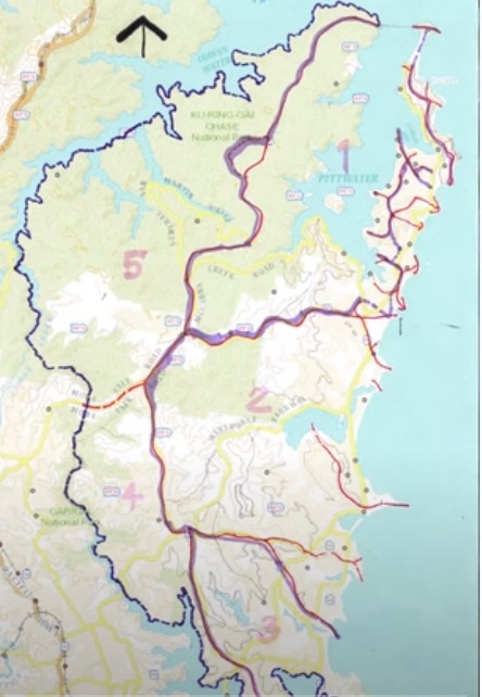
I have a series of images to go with this – this first one is a diagram I’ve drawn over Six Maps which points out the Northern Beaches Council area has six different component areas, I’ve defined them by catchments. Number 1 is Pittwater to the north, which involves the landed peninsula and the Barrenjoey Peninsula and part of the dissected sandstone plateau and Bayview and Scotland Island in the middle. I’ve been a resident of Scotland Island for 51 years, so I’ve got to know the place reasonable well.
The second area is a central complex of the sandstone plateau, freshwater drainage coming down into lagoons and Pittwater swamps, and then beaches and headlands.
The 3rd one is what I call The Manly Complex, which is bordered not only by the Tasman Sea but parts of Sydney Harbour. The 4th one is the Middle Harbour Estuary, and the 5th one is The Cowan waters Estuary. The 6th one is the Tasman Sea itself.
What’s important about Pittwater is it’s got the biggest estuarine complex of what I call those six components, it is spatially contained.
Although I don’t have time to go through the methodology of the study, part of this was to identify, form my point of view, landscape types. You can see this very clearly on the aerial photograph; you can see the urban and suburban areas and also see the vegetated areas and in comparison, those that are not. For instance in the Lambert Peninsula you can see it’s very green and vegetated, and then you have Brookvale and Dee Why and bits of Mona Vale are coming up as very white, urbanised, pathological spots on the map. It’s easy to map that out.
So it’s a lot about mapping and seeing things.
Part of that Heritage Study is looking at the history of things, so this is the very earliest mapping of the northern beaches by Major Mitchell in 1834. This identifies the landform reasonably accurately; it identifies the wetlands and alluvial areas and the sandy areas adjoining the remnant geology.
In the early 19th century, they didn’t draw contours on maps, they just had shading.
This next map is from Professor Griffith Taylor in 1958. He saw it as a series of islands, with the geology of Narrabeen and the Hawkesbury joined together by sand and alluvium. In those areas you get the wetlands and the lagoon and the beaches. The headlands he saw as the islands; you’ve got Barrenjoey, Long Reef, and North Head, and he extended that further.
So it’s a way of looking at the structure of the whole of the place, and how does Pittwater fit into that – and Pittwater, I think, is very special.
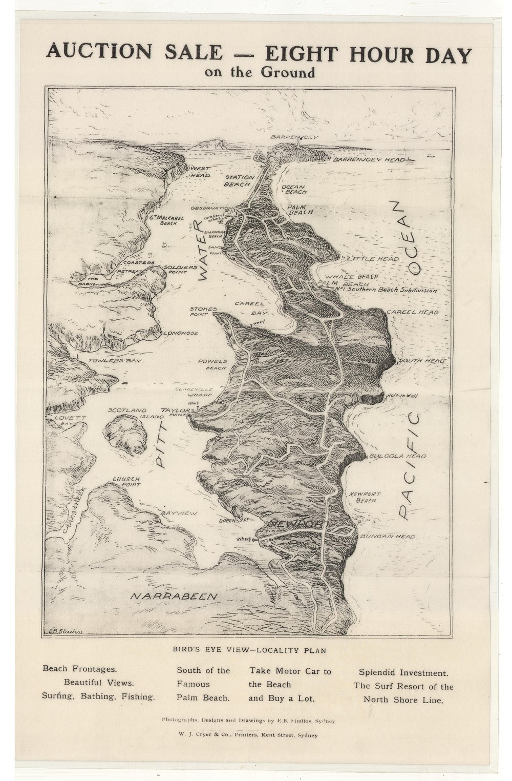
We come to Pittwater itself and an image sent to me by a good friend, Rod Simpson which shows Pittwater in essence. You’ve got the Lambert Peninsula on one side, which is a National Park, and that’s a very visionary statement, and on the other side we have the Barrenjoey peninsula. This is a sales brochure but it’s a very interesting 3-dimensional view from above. It’s not quite accurate when you get into the detail,. But it’s the nature of the forces of the real estate trade when you get into the reality that we’re in.
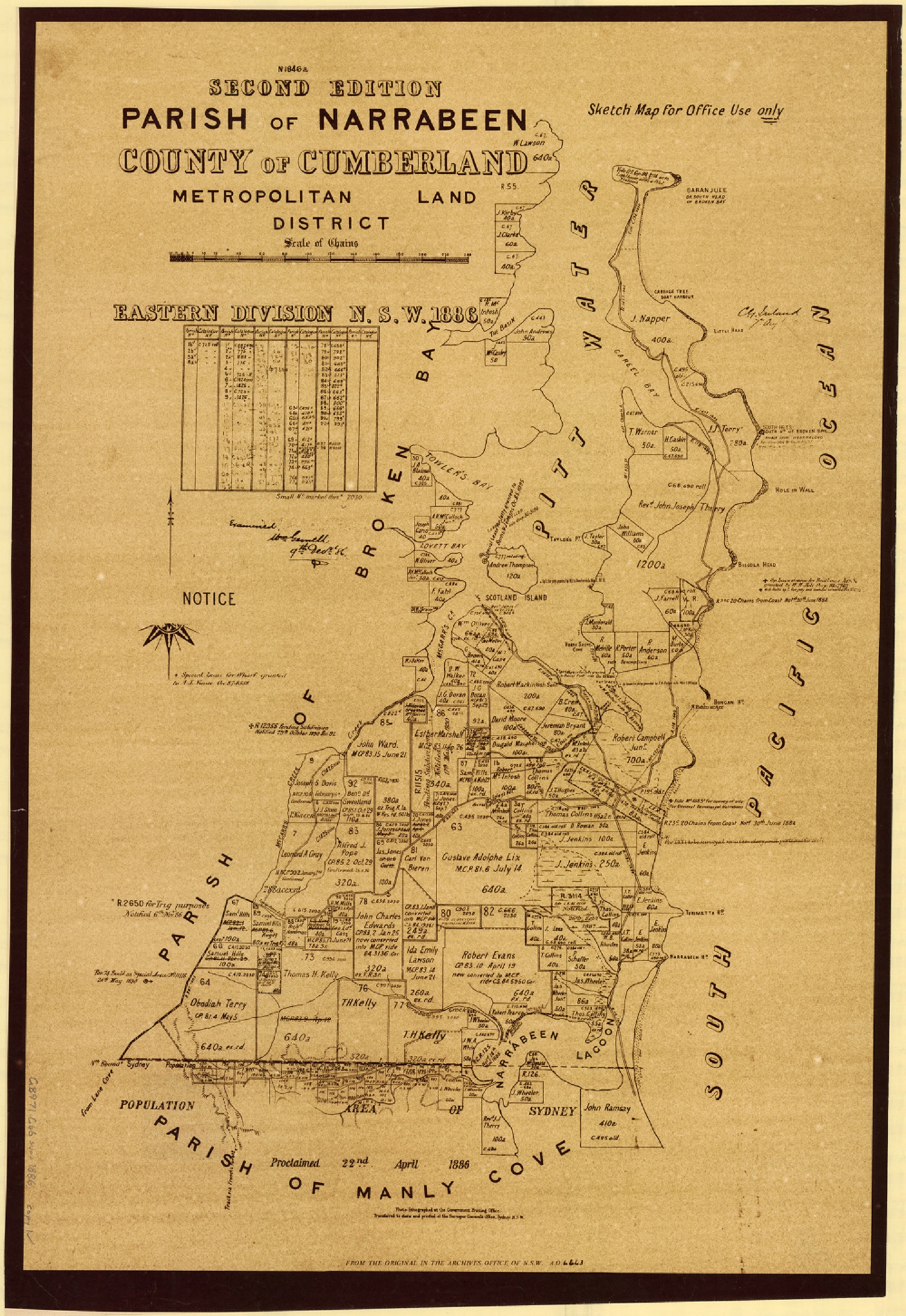
Part of that study was getting in to what I call the marks made by the European mind; the idea of grants of land and subdivision which has resulted in much of the suburban environment that we know; the roads and all around them. You don’t need to see the detail here but these are the Parish Maps which identified the very first grants and how they’ve been broken up into smaller parts, and how we’ve got to where we are today. I was looking at this in 1988, and it has deteriorated even more today.
New South Wales. Department of Lands. (1886). Parish of Narrabeen, County of Cumberland Metropolitan Land District, Eastern Division N.S.W Retrieved from http://nla.gov.au/nla.obj-233833505
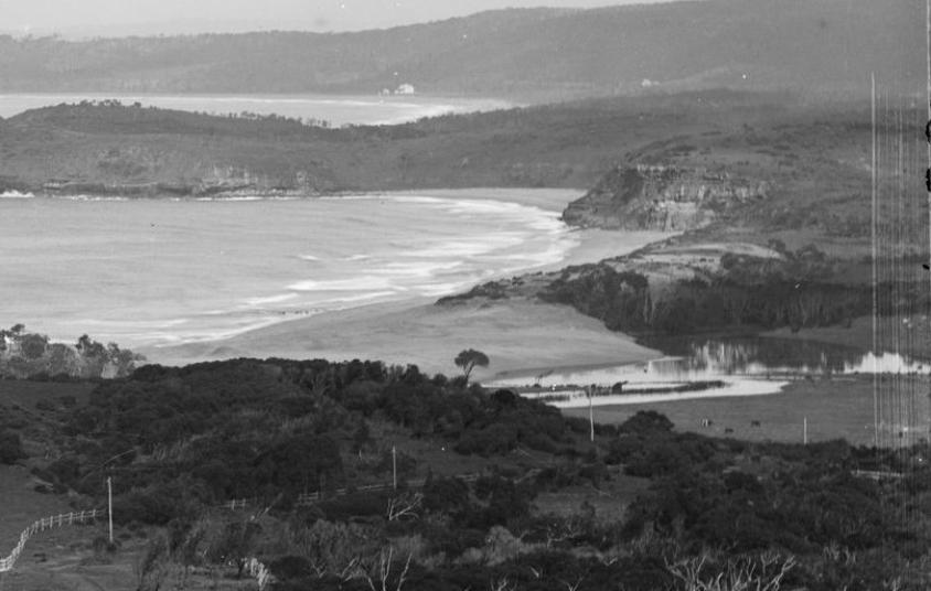
Historic imagery is always evocative and Pittwater was known as ‘The Lake’, in contrast to the sea – so you have this wonderful sense of contrast between the open ocean and the Barrenjoey Peninsula, the Lambert Peninsula, and then the waters of Pittwater. And not so many boats in 1899 – this could be Richard rowing back to Lovett Bay.
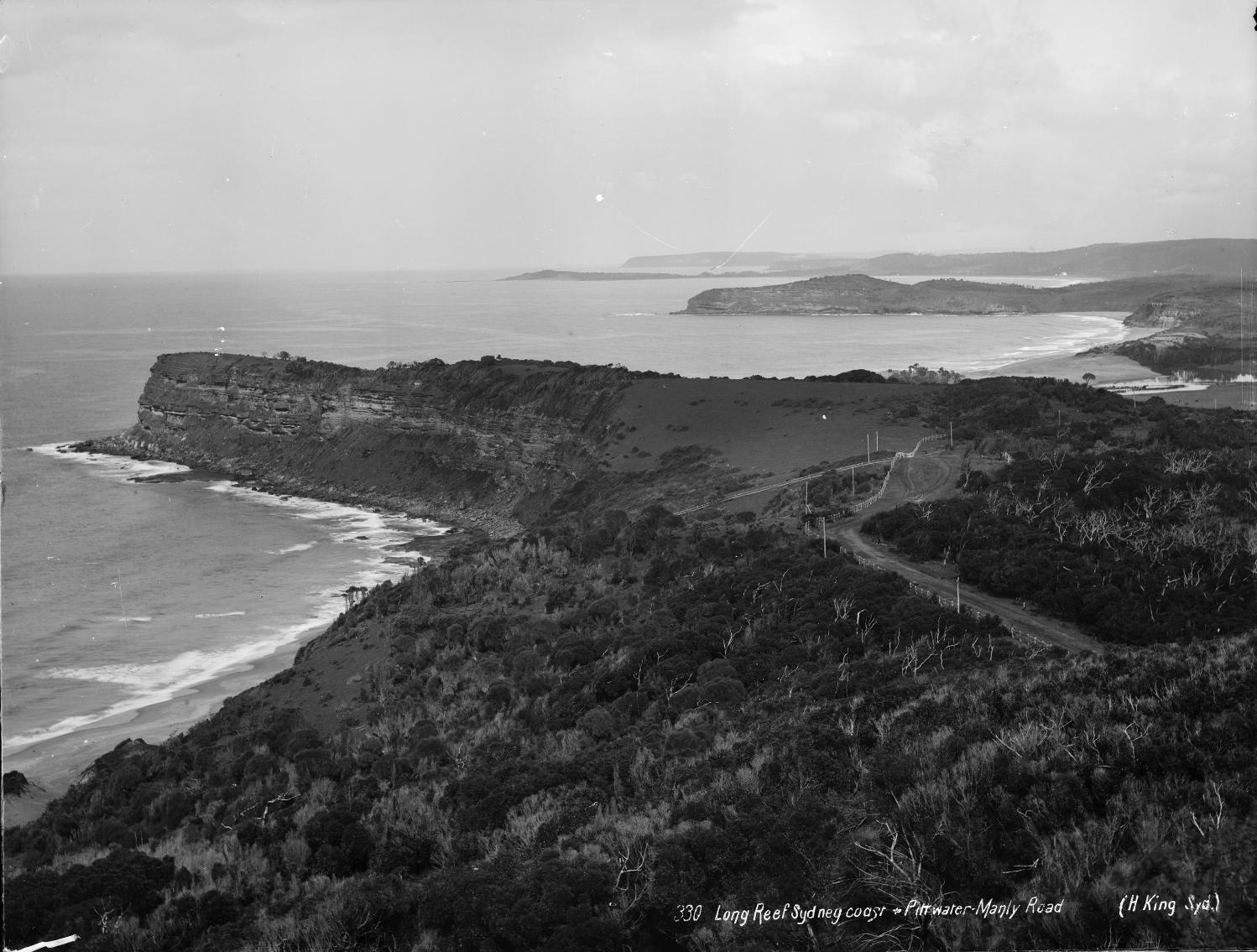
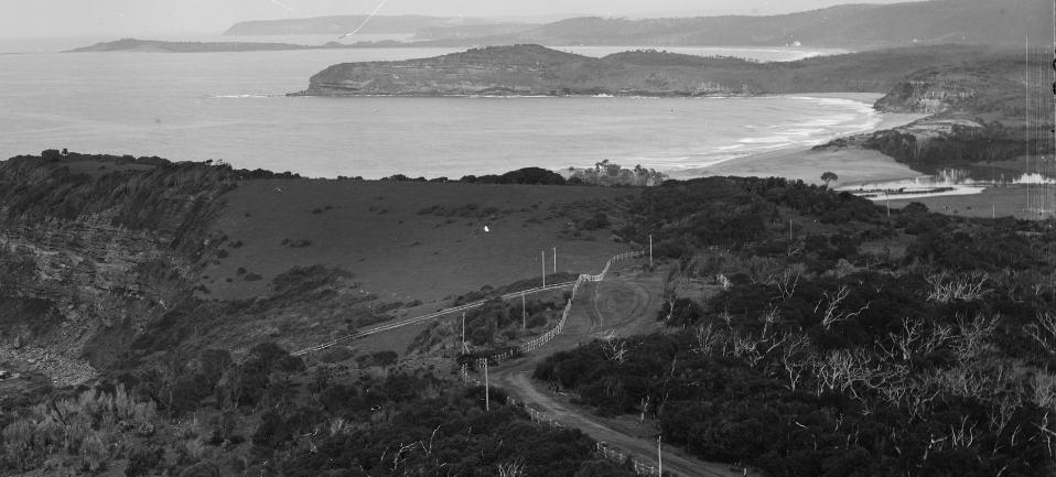
The other aspect of the Barrenjoey Peninsula is this view from Bushranger’s Hill looking south where you can see the pattern of the residual headlands, the beach embayments, and you can just see a bit of The Basin at Mona Vale with its wetlands coming in; very extensive wetlands and lagoons, all now filled in of course.
I think it was Governor Phillip who first climbed Bushranger’s Hill and looked down and described the environment and how marvellous it was.
You can’t see very clearly here – but there were large areas of burnt bushland, which had obviously been managed by indigenous cultures – so there was much clearing through burning (to attract wallabies – kangaroos) – so they thought this would be good for sheep.
So there is this process of going through the history and understanding that to come up with something that has bearing on this places’ significance.
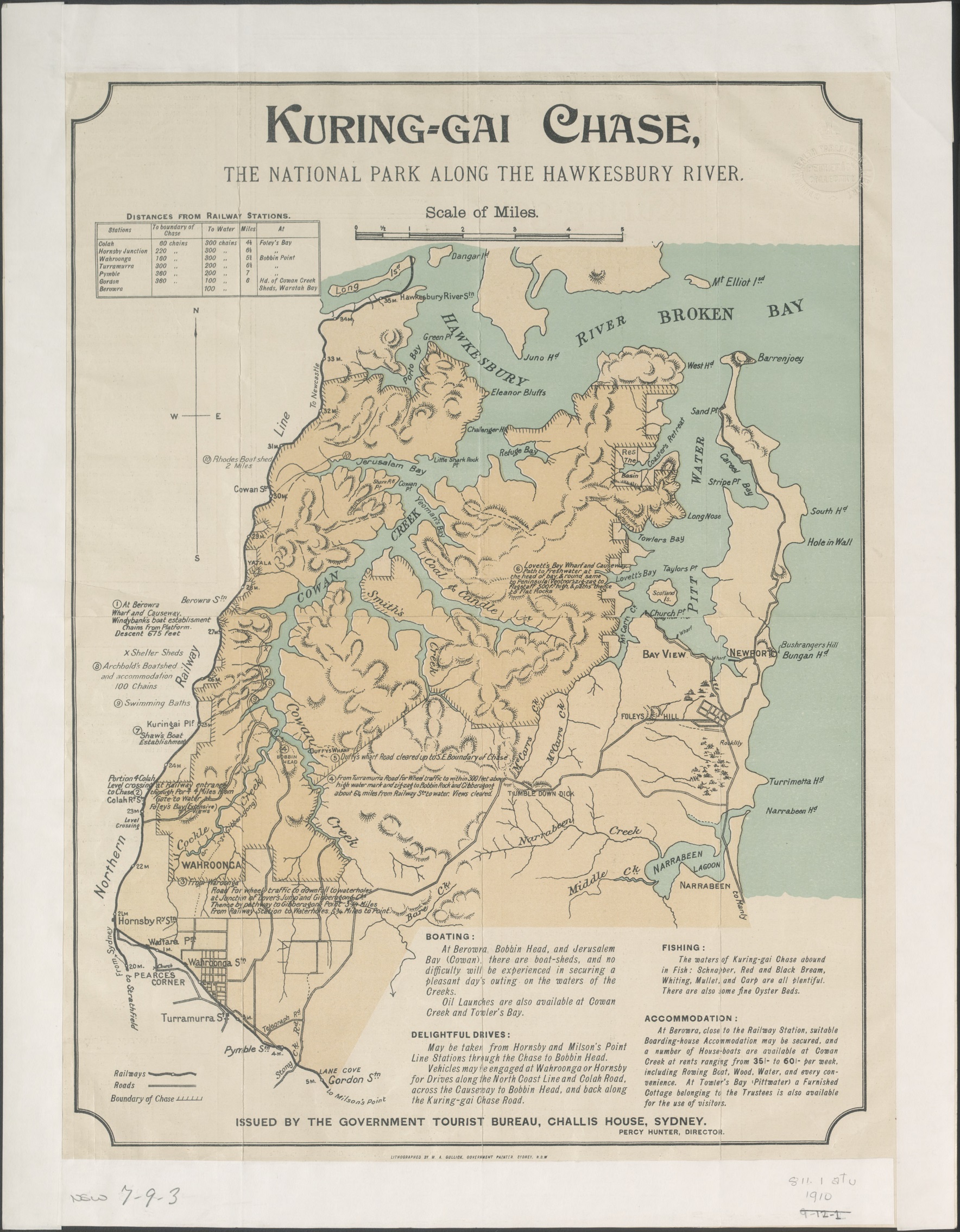
In that journey, in 1894 we have the vision, and there’s very few visionaries that evolved here – this is the vision of Eccleston Du Faur, the surveyor from the Lands Department, who fought for the establishment of the Ku-ring-gai Chase National Park.
Ku-ring-gai is his white man’s dream of an aboriginal place.
The vision to conserve the beauty of nature and the scenic wonders of Pittwater was one of the visions of Eccleston Du Faur. He was also responsible for establishing reserves in other parts of New South Wales.
Gullick, W. A & New South Wales. Government Tourist Bureau. (1910). Kuring-gai Chase, the National Park along the Hawkesbury River Retrieved from http://nla.gov.au/nla.obj-232186503
It’s a great shame to me that he didn’t go far enough and take the Barrenjoey Peninsula into the National Park, and not just Barrenjoey Headland itself. I think that’s one of our answers to the conservation of this place, in that we could do as people do in the Lakes District of England, where when you’re living in a nationally significant landscape and environment, you can still have development and residential development but it becomes a matter of ‘how do we do that?’.
The divide here is one is National Park and one is freehold, real estate.
This a drawing of mine from last century from my verandah on Scotland Island. You see the water plan of Pittwater is a very important element. Then you see the landform. So the two things become very important in terms of the heritage; is the water body itself and the landform. The fact that you frame views through trees of the woodland. The trees are disappearing, the boats are increasing – I think at some point you won’t see water when you’re down at the water level, you will just see masts and yachts.
I’ve been guilty of that, I’ve got a mooring. That’s the kind of visual structure I was interested in looking at; to understand and to respond to the naturalness of the place.
This is the cover of the study, there’s four volumes. There were four of us who worked on it.
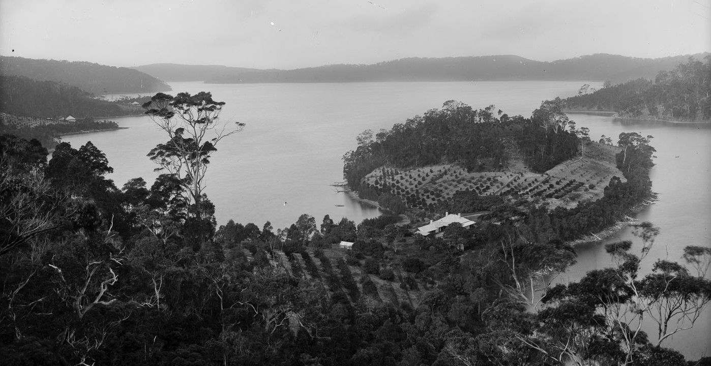
Here is another historic photographs – this one on the western shores overlooking Ventnor and Rocky Point, between what is now Elvina Bay and Lovett Bay, Scotland Island and the peninsula in the background. This is the 1880’s; there’s orchards and rural activity along with boats – but there’s a semblance of and you can still read the naturalness that’s in the place. And that is what is eroding away very slowly. In landscape terms that erosion is very subtle for people, they don’t realise that it’s gone until it’s actually gone. You can get accustomed to change and not understand what’s actually happening to you (and a place).
'At Pittwater' by Charles Kerry, circa 1887-1888. From Tyrell Collection, courtesy Powerhouse Museum
We use historic images to try and understand what it was like, what it is like now, and how it could be in the future. There’s lots of design and planning that can be put in place to conserve the elements of these things. The conservation is not purely for Nature, it’s for the cultural aspect as well – the indigenous culture, the European culture, and hopefully Australian culture all coalesce together.
The net result of this is a lot of mapping – and this is the most significant map I think because it’s the area of significant visibility. The area that’s hatched in is that that I see as the most significant area to be conserved. I would think that this could be a conservation area, and it doesn’t matter whether it’s a European residential area or a National Park, in that the sense of naturalness should pervade the whole place, the qualities of that.
So this was presented with recommendations and I’ve got copies of the recommendations here – there were 28 recommendations for the conservation of this area, as well as other things that we identified. It’s not exclusive to Pittwater itself, it goes out onto the headlands and coastal sections of the Barrenjoey Peninsula. We were limited in our study to Mona Vale Road, coming down Foley’s hill and into Mona Vale, and it was done for the secession of Pittwater from Warringah. So there was a kind of rubbery edge to it.
I was suggesting that everything in that shaded area would be subject to a DCP which would be lodged in an LEP, and nothing ever happened. Warringah (Council) know, Pittwater (Council) know, Northern Beaches (Council) know.
So it’s timely to come and revisit this and revise it, revamp it, bring it up to date and understand it better because I arrived at this from looking at the viewpoints form public spaces; from the water, the ocean, from roads, and form lookout places that are used by people who come to see the landscape. So it’s a landscape area; it comprises very much the slopes.
Some of the points were about preserving tree canopy, responding to the different ecologies of wet gullies to dry slopes to wet slopes, to different aspects and then to different elevations. Then waterfront character; not to fill in the bays, not to straighten everything, to keep that informal curvaceous edge to the line of the water body.
Among the other recommendations was one that any buildings would be subservient to the landscape.
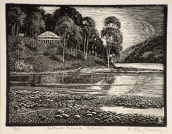
This is a nice woodcut block done in 1925 by a friend of my father-in-law who was also an Artist. This is my house on Scotland Island in 1925; there are no other houses around. It is now much more suburban than that. How wonderful for us to have this balance between conservation – the human things and then the natural things.
Artist: DAVIES, L. Roy. Title: Scotland Island, Pittwater. Date: 1925. Technique: wood-engraving, printed in black ink, from one block. © The Estate of L. Roy Davies
That’s a plea from someone who is concerned about these things.
.jpg?timestamp=1659197187832)
.jpg?timestamp=1659197224935)
.png?timestamp=1659197544997)
.jpg?timestamp=1659197720369)
.jpg?timestamp=1659197956008)
.jpg?timestamp=1659197979832)
Anna Maria: Thank you Craig, much appreciated – that’s on our mind much around here.
Our next Speaker is Richard Leplastrier, one of Australia’s most influential and internationally awarded Architects. Richard likes to be described as a practicing Architect who for decades has been living on the wild side of Pittwater and is always keen to exchange ideas and concerns with others.
Thank you, Richard.
Richard Leplastrier:
Neil, thank you so much for the Welcome to Country. My family and I live on the wild side of Pittwater in a very simple little house that belongs in the landscape and the place. Scarcely a day goes past without our thinking of that amazing culture that has gone before us, a lot of whose knowledge has been lost, so it is just with great respect that we hear about more of that. So thank you very much for that.
That’s a brilliant Heritage Study of which Craig has just informed us. Its very rare that you will see something done with such sensibility and such connection to a place. And it’s not surprising that the bureaucracies have taken no damn notice of it whatsoever. And I think it is high time that we, collectively, did something about it, which is why today is so important – Anna Maria, thank you so much for taking this up.
For nearly 70 years I’ve sailed on Pittwater, and over that time you get a sense of the pulse of the place; all its weather systems, and its calmness and its velocity, and it is, as we all know and love, the most amazing place.
It has an ethos about it. It has an atmosphere about it.
What are those sorts of things that give it that quality?; Craig was able to describe them very clearly.
Can I put it to you in a very simple way; somebody has come to you with a Persian carpet, and it is worn out in the middle from the footsteps of time and families. This person has come to you with your expertise and said, ‘can you please repair this carpet for me, it belongs to our family?’.
The first thing that one has to do, as you would appreciate, is you have to find the weft and the warp of that carpet – the structural strands which are laid down in different colours through which all the patterns are woven. If you don’t find that first structure of it, whatever you do with that carpet will not be long – be long; to be for a long time.
What we’re talking about today is be longing in this place.
I want to start from not so long back because our first Australians have been here for a long long time. They have understood this place brilliantly and hold the lessons we all hope are starting to come through to us now.
If I could go back 16 thousand years, when the ice caps were starting to melt, and places that we know like our Sydney Harbour and Pittwater were actually valleys, treed, with streams running through them, because the great ocean was ten miles out to sea at the edge of the continental shelf, and that slope from the cliff faces which still exist now, that slope out to the edge of the continental shelf, was the great eastern plain of this country. And on that plain were all the original inhabitations of the saltwater people.
From the time that the icepacks started to melt and the waters started to rise, and they rose something between 200 to 250 feet, from that time onward Pittwater slowly started to come into being.
We have the technology today to look at the underwater contours of Pittwater and see where all those rivers ran. We can see where the undersea mounts are. We can see where the holes of the deep parts are.
When you start to know Pittwater well, you start to ask questions of the place. For example; why are the pits deep off Portuguese Beach? And that amazing strong headland; why are they there? Because even when Pittwater was rivers and forest, that part (off Portuguese) would have been a lake which would have had great significance I feel.
So the first thing that one has to do is look at the underwater terrain, once the sea level is in there you can’t see anything; it’s out of sight and out of mind. When you see that you start to realise that the points of ingress in Pittwater of the water catchments are absolutely important.
So Pittwater, if you look at it as a great water rune, has three sides. One side is the so-called cultured side; the side with all the development on it, all the way to Barrenjoey almost. We have the other side, which I always call ‘the wild side’; Nature.
So we have Nature, the wild side, and the so-called cultured side, then we have what’s facing the Bayview side, which is undergoing such change at the moment through home units being built, that if they keep on going in the way that it is with that, and I don’t say we collectively, I say councils’, then Bayview will change unbelievably. The trees will go and it will be more like the Eastern suburbs and Vaucluse, where you can barely see a tree. That’s what is going to happen – so that has to be discussed.
Density will change because we get more people, but there are ways of doing it well, and there are many ways of doing it badly.
If you get up to 50 thousand feet and look down on Sydney, we have the city of Sydney and Sydney Harbour, we have the Royal National Park to the south and Wollongong, we have the Blue Mountains National Park and the mountains’ towns, and to the north we have Newcastle and the great National Park on the wild side of Pittwater.
Sydney will become a coalescence of Newcastle to Wollongong – there’s no way that we will stop that. As soon as they put a fast rail in, it is on.
So what happens is that we have three brilliant buffer zones – the Royal, the Blue Mountains, and the wild side of Pittwater.
So rule number 1 has to be that the wild side of Pittwater has a whole set of conditions about it. The first one is that those places that have been put aside for housing must have a set of rules that makes us make those houses small and not big. We don’t need a lot to live in this country, especially with our climate here. You can make small houses really beautiful to live in.
The danger is that money comes in, and if there’s no rulings about the place, more of these monstrosities are going to go up, which we’ve seen happening on the cultured side, and that ethos, that atmosphere of the wild side of Pittwater will be lost.
When you look at Pittwater as a whole it has a whole series of points that come out – I’ll just name them quickly; Stokes Point, the edge of Careel Bay and Palm Beach, Taylors’ Point, Clareville with its wonderful public forecourt to the water and the houses tucked back – good decision, Green Point; which was the most wonderful like a duck’s bill shape that went out with fine edges and is now Crystal Bay at Newport. Green Point, RPAYC, started as a boatshed and now is this anonymous glazed in monstrosity and it destroyed that point of land completely. And I’m a sailor – I’ve sailed out of there – but it is not a good imposition on that point.
Church Point; wonderful Church Point where many of us live – my friend Karen and my partner were doing some research and went to the archives of Sydney to look for some of the first maps and drawings. She found one form 1820, a whitefellas map done by a surveyor, and in immaculate copperplate writing across Church Point were the words ‘wee-waa’ – when you check on the meaning of that it means ‘go away’.
He thought it meant that that was the name of the place.
But what that also says is that Church Point is a take off point to all the others sides of Pittwater – it’s a landing place, it always has been, forever and a day.
When the sea levels rose Scotland Island became an island. Before they rose you could walk across to Scotland Island – it’s a shallow zone, you can see it on the underwater terrain.
So these are the sorts of things that one has to do in order to be able to come to grips with how you make change that belongs.
If you look at this side, the so-called cultured side, there are shifts there now that are getting many of us really anxious. More people are going to come here to live; ok – how do you make denser housing that can have gardens where that can also allow for expansions for inter-generational housing so that grandparents, parents and kids can have their lives going on in there – it can be done, and we have the minds in this country to do it.
Why has that not been seriously thought about?
Then if you think about the chain of beaches between Manly and wonderful Barrenjoey, you realise that all the little townships that have gathered about those beaches all have different backgrounds. Brookvale; the 'valley of the brooks' is what it means, and that’s what it was. If you look at Pittwater Road it goes right around the back of Brookvale because you couldn’t get across the middle of Brookvale because of all the wetlands and the drainage systems. They smashed the road through, filled it all in, and it’s gone.
But ‘is what is past retrievable?’ is the question to ask for the people set up to deal with this. Help them – that wonderful golf course with those screens of trees that lead up to the Manly Lagoon – thank heavens that that is there.
Those sorts of great green areas that have been left should not be interfered with.
Mona Vale, right outside of here – the park, which has buildings in it now but a lot of it left, was a waterbody – a wetland. That shouldn’t be grassed, that should be the most beautiful park where people can sit, enjoy the water, sail their model yachts, kids could paddle in some part of it. That’s what belongs there. At some stage it went through to the sea.
I remember where the industrial area of Mona Vale is now belonged to Sir Edward Hallstrom and he used to grow his grasses for the zoo, and there were albino kangaroos there, and it was suggested to the council that that land should be taken over and used as parkland that connects Mona Vale, or Turimetta, that was its original name, that Turimetta should go back to its original connection to Pittwater because of all the waterbodies here, and down there where the industrial area is, drain into Pittwater. You don’t put industries into a place that drains into a beautiful place like Pittwater. If you do you have to go over those drainage systems, reconstruct them, take out the concrete edges to it, make planted systems, hold the water back in a small series of dams with fingers that go out into other areas. These are base movements that have to be made.
Those salient points on Pittwater I mentioned; Woody Point, Long Nose Point, Soldiers’ Point, Church Point – they are precious, because, as Craig’s beautiful images show, they come out like fingers on a hand and you can see the perspective of distance as the receding headlands disappear into the haze. Never to be built on really. There are some houses on some of those points which are just ok – there are a couple of houses there that if they are taken over and poorly rebuilt on, Woody Point which is a symbol of purity to all of us on the wild side of Pittwater, would be decimated.
So those salient points have to be totally protected – housing has to be made small and respectful, recyclable so the materials can be reused – and so the story goes on.
It’s a complicated but actually simple set of conditions. So I’d just like to put that to you as a concerned group.
In closing I’d like to say to you as well, I personally don’t like dealing with a council, but, I would much rather deal with a Pittwater council than a Northern Beaches council (applause breaks into address) and that the smaller and the more local government is, the more chance we’ve got.
Thank you.
Angus Gordon OAM:
Thank you, Anna Maria. Interestingly I’m here as an Engineer and surrounded entirely by Architects (laughter) which is supposed to be a very dangerous thing to do, nearly as dangerous as putting your hand up to be General Manager of a council.
It’s interesting as Rick and I used to race against each other in the early 1960’s, and so do go back a long way, and he talked about the underwater mapping and of course that’s exactly the work I was doing before I became General Manager of Pittwater Council.
What I’d like to do today is take you through a few things that I was taught and learnt as General Manager of the council about planning.
The key thing here is that Planning should start with Visions and Outcomes.
NOT Formula.
LEP/DCP’s are formula processes; documents to deliver the visions, not create them.
That’s a really important thing to realise. The State government didn’t really like the way everyone was putting their DCP’s and LERP’s together because they represented too much of what the locals needed and wanted, and so they introduced the Standard Instruments.
The ‘’Standard Instruments‘’ are formula, not visions.
And again this pulled apart some of the really good work that had been done in Pittwater.
They miss the first vital step of looking at Visions and Outcomes and drive repeatable mediocracy; what you might call the McDonald’s planning. And the reason they do it is just simply to make it easier for developers and the State government- if you really get into it, that’s what you find out.
What I learnt, which follows on from the previous two speakers, is that the whole Pittwater LGA is a string of villages and settlements each with its own culture and sense of place. Sense of place is a very important thing.
It is a series of ‘valleys’, ‘watersheds’ and offshore communities sharing a common thread of environment and community.
This is Generated by the natural surroundings of bushland, ocean, estuary, lagoons and creeks. So the Vision, if you’re going to have one moving forward, should include concepts like:
- Buildings nestled in trees
- Frogs and water dragons in creeks
- Birds and possums in trees…and koalas?
- And a lot more
NOT roads falling to bits and parklands overgrown with weeds
In fact when we revising the LEP for Warriewood Valley I got quite a few people form the community and from council and we went away for a day. The first thing id di was say ‘close your eyes – for the next half an hour I want you to think about what it would be like walking through the streets of Warriewood Valley in 20 years’ time. What would you like to see?’.
What we came out at the end of this was people agreeing on what they thought it should look like. In fact, much of that was achieved – right up until the State government stepped in and started to really stuff things up, which they have done terribly. I must say that I’m not impressed by the Planning Panel either and a number of decisions that they have made.
This is because we’re dealing again with instruments, not visions.
I would argue that much in planning is what we all discretionary; that’s whether or not you have small or big houses, what distance from the street or waterbody you place houses, maybe even what colour the rooves of the houses are; these are discretionary issues.
As an Engineer what troubles me is we don’t look at the things that are controlled by Nature, the natural hazards. Mind you, they’re only hazards if you put things in harm’s way.
Naturally, as Nature, they are not hazards.
Planning should therefore aim to minimise and manage exposure to ‘Natural Hazards’ – NOT treat them as though they were discretionary – An expensive mistake both financially but also mentally, as you can see what’s happening in Lismore and also along the Hawkesbury- Nepean catchment.
The interesting thing in Pittwater that I found is that the Pittwater LGA had over two thirds of the dwellings affected by one or more of the following:
- Flooding
- Bushfire
- Landslip
- Shoreline erosion (coastline and estuary)
- Windstorms
- Acid sulphate soils
Yet the PLANNING of the State Government simply makes these ‘’matters for consideration’’.
We can no longer afford to put people in areas of high risk.
The interesting thing is the federal government had a commission look at what ahs occurred in Queensland in 2011 and worked out that what happened between the government and private insurance, the losses that occurred then were over 30 billion dollars. You may not remember this, but you had to pay a surcharge on your taxes to pick up that tab.
What do you think is going to happen now in view of what’s been occurring – where do you think we’re heading?
We can no longer afford to put people in areas of high risk.
So that has to be built into the Planning.
I’d like to change tack a little bit now:
Are Amalgamations a good idea or do they have a history of problems?
Amalgamations came about through this argument of economies of scale; the problem with that is it dates back to the Industrial Revolution and past centuries thinking, before computers – you don’t need it anymore, it’s a silly way of doing things, it really is – and you don’t need this when you have computers.
What Amalgamations do achieve is:
• Large Councils are easier for the State to manage because they’re so big and clumsy, and this makes it easier for the State to take away powers from them.
• Good for consultants because large clumsy organisations generate work
• Good for consultants because they serve on planning panels while also working for developers, and most of the consultants serving on Planning Panels also work for developers (or in those fields). That’s not a corruption issue, just a conflict (of interest) I think.
• Good for developers because councillors can no longer "interfere" with DA’s, they can’t get involved – so why do you have a council again?
• Worse for the community as they lose sense of "place" – and I’m really seeing that happen here. The sense of place we had here when I was GM was amazing, we had about 40 different Residents Associations; there were people I could talk to, people who could talk to me and they could convey their sense of place - it was important to be able to do that.
• Worse for the community as they lose ready access and timely response
• Worse for local contractors as they have difficulty competing against large non-local firms. This shows when we have problems with storms – you try ringing up a large contractor then and they’re unavailable. Whereas, when we had problems I could just ring up a local contractor and they’d be straight down and get the things cleared. We had a number of local landslips back in the late 1990’s, and they occurred at night, I think there was over 20 of them, and I was able to get the local contractors out there by 3am in the morning and start clearing and saving houses. You try t do that with a big contractor – not a chance.
And... Large councils COST MORE! No matter what people argue, this is what happens. And one of the reasons is that you actually need a bigger Management structure. You need for larger management structure to risk manage activities and constrain "staff initiative". This is why at Pittwater Council we had just over 300 employees, and it didn’t take me long to get to know many of them and to understand their limitations and their strengths. That meant I was able to delegate, and they gave me a lot of feedback on what we could improve in the area.
The bigger a council gets the less you can afford to have that type of connection. That’s not just the situation with councils, that’s also the situation with businesses and why you see so many break themselves down into separate business units – for that very reason.
There’s also the loss of time to access job sites from more central locations.
You lose the understanding infrastructure systems and lose the capability for rapid response
And LOTS more!
The current scorecard, what I’m seeing and what I think is important for all of us to focus on is:
- the Lack of Vision and understanding of the differences between the LGA areas – Manly is very very different to Belrose, Belrose is very very different to Newport or Avalon or Scotland Island. That is lost.
- we have a problem with ''Community consultation" which seems to be aimed at making people "feel" they are being consulted. There is actually little, or no notice taken of community views and concerns. The council has a very bad record on that.
- Lack of internal knowledge and History, and that’s because people have moved on, resulting in overuse of consultants
- there’s obviously over-development occurring, with extensive and excessive removal of trees
- Roads narrow and fit for purpose for those with 4 wheel drives
Unfortunately even the trivial things are being ignored; Leaf litter clogging drains and rubbish adversely impacting wetlands. One of the things I did was purchase a number of streetsweepers because we then lived in a very treed area – we had them running all the time, not because we wanted the streets to look pretty, but because we didn’t want them getting into the drainage systems and into the wetlands and estuary or onto the beaches and into the water. And of course those leaves made great mulch for the trees in the parks; this was a very cheap way to feed those and reuse those materials.
There's no encouragement for working from home and hence less demands on transport. We brought in a working from home policy in the late 1990s and via that we were able to retain some really really good staff members, many of whom were women who were having children. By bringing in that policy we stopped losing that talent. Working from home under that policy was delivering the list of tasks needed to be done and providing a timeframe by which they needed to be done – this worked for us and those people who worked from home.
What we’re finding is the council is excellent at lots of expensive PR spin doctoring, they’re brilliant at it.
Finally, the last slide – of course I’ve been jumping up and down about this seawall for quite some time as I was in Coastal Engineering and quite frankly it’s a disgrace, and also an embarrassment.
This is brutalist engineering in my view, form the last century. I must say I borrowed this off social media and had been posted by our new Federal Member – I just thought this was a beautiful point. In the Coastal Act it actually says that for the life of the structure you have to have access along the beach. Now it’s only been there a couple of years and look what you’ve got. Council is already erecting signs that say ‘danger – you can’t access the beach’.
Ladies and gentlemen, listen to what’s being said here today about the need to ensure that planning comes from vision – it doesn’t come from formulas. The formulas, the DCP’s and LEP’s are what you have to implement the vision, don’t get it round the wrong way.
Thank you very much.
.jpg?timestamp=1659198244917)
John Illingworth:
Thank you – I’d just like to say a couple of quick things. We’ve had some terrific speakers here and some wonderful points of view.
I was born here. I grew up with koala bears, but the place is changing.
We’ve been done over repeatedly by governments when we lost Pittwater. Pittwater at that stage was maturing into something that was really going in the direction which you speakers today have articulated so well today.
And it was just cut from under us.
There’s a State election coming up, there’s a very good chance that the Liberals will lose power, and Labor, if they do get in, have told us that if we fight for Pittwater, they will help us get it back.
It is political, unavoidably – and so the only thing to do is to struggle to get Pittwater back, because that was an excellent council, no matter what anybody tries to tell you or say, and be prepared to pay an extra rate, because if you want to live in a special area then it’s going to cost money to protect and look after that area, but we must do it. You must tell your neighbours that they must be prepared to do it.
Then if we are ready when the state government falls, we have a chance of bringing back our council and bringing all of this to fruition.
Planning forum speech delivered on Sunday, July 24, 2022 by Ethan Hrnjak on behalf of Cr. Miranda Korzy (who was ill with Covid), emailed in from Cr. Korzy
One of the most important tasks for the current council is developing a set of new rules to govern development from Manly to Palm Beach and inland to Frenchs Forests. It’s an enormous undertaking, involving challenges like harmonising the old E4 environmental zones from the three different Local Environment Plans of the former Pittwater, Manly and Warringah Councils. For example, under Manly’s current rules, blocks of units are permitted in E4 zones, while in Pittwater this zoning is meant to protect trees and limit hard surfaces to no more than 40 per cent of a block.
We also face pressure from the state government to develop housing for a population increase on the Northern Beaches, projected to rise from 272, 322 in 2022 to 312,503 by 2041. At the same time, we have a shortage of more than 8,000 affordable homes across the LGA.
With this backdrop and the new draft LEP due to go on public exhibition later this year, it seemed to me timely to have a public discussion about our environmental and built heritage: what’s special in Pittwater; what’s at risk; and what we want protected.
As it turned out, I was in iso with Covid on Sunday so couldn’t attend the forum. However, I’m told discussion inevitably turned to council demergers. I’ve campaigned for and made it clear that I would like to see Pittwater Council restored. I also support a demerger protest planned for outside Parliament House on Macquarie Street, on August 9 at 1pm.
However, whether we see a demerger or not, the LEP currently under development will remain in place for at least five years before it’s reviewed and the current Pittwater LEP/DCP dates from 2014 - with some amendments. So it’s important that we get this right.
Miranda's speech read at the forum by Northern Beaches Greens member Ethan Hrnjak:
I’d like to begin by acknowledging the traditional owners of this land, the Garigal people and to thank Neil Evers for his welcome to country. I pay my respects to their elders past, present and emerging.
The suffering they endured at the time of white contact as a result of disease, violence and displacement is unimaginable. Yet today, the environment we enjoy is testament to their custodianship over thousands of years.
However, in recent years, planning controls appear to have been unable to prevent a swathe of development that is changing the very contours of the land. On environmentally precious sites across Pittwater, we are seeing residential blocks cleared of sometimes 15 or more trees, some a hundred or more years old, then excavations from boundary to boundary and four storeys deep. This is destroying the natural beauty of the area, the tree canopy that provides habitat for local wildlife as well as cooling the area, and even creek lines - as one site at Palm Beach shows.
We know the Pittwater LEP and DCP were very clear and consistent about protecting these landscapes, for example with the 60:40 rule for site coverage. Is it new building techniques that are making previously unimaginable developments possible? Is it an influx of property owners with extreme wealth who are pushing the boundaries? Perhaps a lack of compliance? Or is it a consequence of the removal of decision making on DAs from councillors? At the May council meeting, I moved a motion asking for a review of why these developments are occurring - with the hope that this information could feed into the new LEP. The report was due within two months, however, I’ve now been told councillors will be briefed on it on August 9. So many questions remain.
However, we know from council surveys that environmental protection is the highest priority for Pittwater residents, as for those across the rest of the Northern Beaches.
So any existing weaknesses in the Pittwater LEP and DCP must be tightened up. CABRPA president Catherine Kerr has organised a number of forums over recent months inviting architects, including Elizabeth Farrelly, to address residents about the sort of controls that are needed. She has also been exploring LEPs from other council areas. I hope Catherine can recap on these for you - like limits to excavations in conservation zones. It also appears that these controls will need to be included in the LEP to make them enforceable.
Additionally, we need the council’s canopy plan, which has been lingering unfinished since it went to public exhibition in 2018, completed and bedded down. It must have a significant tree register and a strategy for protecting trees on private land - where the greatest tree loss is occurring.
We must also have protections for built heritage - from the old stone cottages of Palm Beach and the Walter Burley Griffin house in Avalon, to the 70s brick and timber bush retreats, nestling amongst the Angophoras, and examples of post World War Two migration and farming heritage. Pittwater Council had put together a list of places ready for heritage review back in 2015 but unfortunately it was shelved because of the council merger.
Then we have our open spaces like reserves, parklands and golf courses. We know that the council has knocked back tenders for Avalon Golf Course, which lies within the 400 metre radius of the Avalon centre. This must remain open space.
And we need the council to be carrying out heritage studies to prepare for establishing Heritage Conservation Areas in the LEP. These safeguard a range of local features that can be significant aesthetically, culturally, historically, scientifically or environmentally.
If we’re to preserve this rich environmental and built heritage, I’d encourage residents to be ready to defend our territory. The council will soon release a report into environmental zonings and I hope that as many people as possible will read it and let the council know what they think. I will certainly be reading these submissions, along with listening to the expert advice staff offer. The current Open Space Strategy is also up for exhibition and there will be more - particularly the final LEP itself.
Talk to your neighbours and friends - because we know the news will spread. And flood councillors with emails. When they receive hundreds of emails on an issue - as I have seen on a couple of issues so far this year - it has an impact.
Please speak at council meetings about planning - or register and write a speech that a council staffer can read out.
And make use of social media and the wider media if you have the contacts. Post about inappropriate development - and publicise great ones too! Look out for more meetings and protests - I know of residents who are ready to lie in front of bulldozers if need be.
Thank you.
__________________________________________________________________________________________
Interestingly, regarding Mr. Burton's presentation, Warringah Shire Council minutes of the Meeting held on September 3rd, 1935 records:
13. Kuring-gai Chase Trust, 21/8/35, re Council's suggestion that the Trust should assume control over the whole of Pittwater, stating it is doubted very much whether the Minister would agree to this, and requesting additional information as to what such control would actually entail. Resolved; That the matter be deferred…
Further, that had been preceded by the then Avalon Beach Progress Association, fed up with inaction in their area despite increases in rates along with extra fees required for other services and council aspirational projects, asking the Warringah council how they could get free of them and set up their own council. They were referred to the state government as a place to seek that information.
That was followed by the Avalon Beach Progress Association in May 1950 requesting and stating:
(10) Avalon Beach Progress Association, 4/5/50, asking the Council to urgently arrange kerbing and guttering adjacent to the new school to be opened within the next few weeks at the corner of Old Barrenjoey Road and Sanders Lane. Resolved, - The Association be informed that as the Council has such a long kerbing and guttering programme for this year, where it is urgently necessary for drainage purposes, it cannot give consideration to this request at present. (Cr. McKay) (11) Same, 4/5/50 informing Council that the Association is dissatisfied with the Council's apparent inability to provide adequate maintenance, construction and drainage in the locality, Avalon that the majority of roads and footpaths are in a deplorable condition, and if necessary improvements cannot be carried out by the Council's staff, the construction work, if possible, be immediately let out by private contract; and contending that rates and services are on the increase without any apparent benefit to the ratepayers. Resolved, - The Association be informed of the large amount of work to be done throughout the Shire, and that such work is held up owing to the acute position in regard to labour and materials.