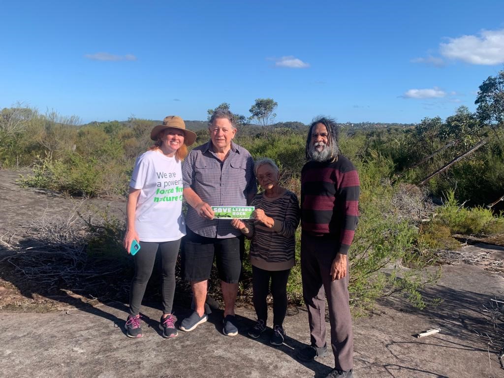
On Sunday January 8th 2022 First Nations elders Uncle Neil Evers, a direct descendant of Broken Bay father Bungaree, Aunty Clair Jackson and Brewarrina First Nations leader Bruce Shillingsworth met on land adjacent to the proposed Lizard Rock development at Belrose through a walking and appreciation celebration of land and culture event organised by Nicole Romain, one of the founders of the community group, Save the Northern Beaches Bushland.
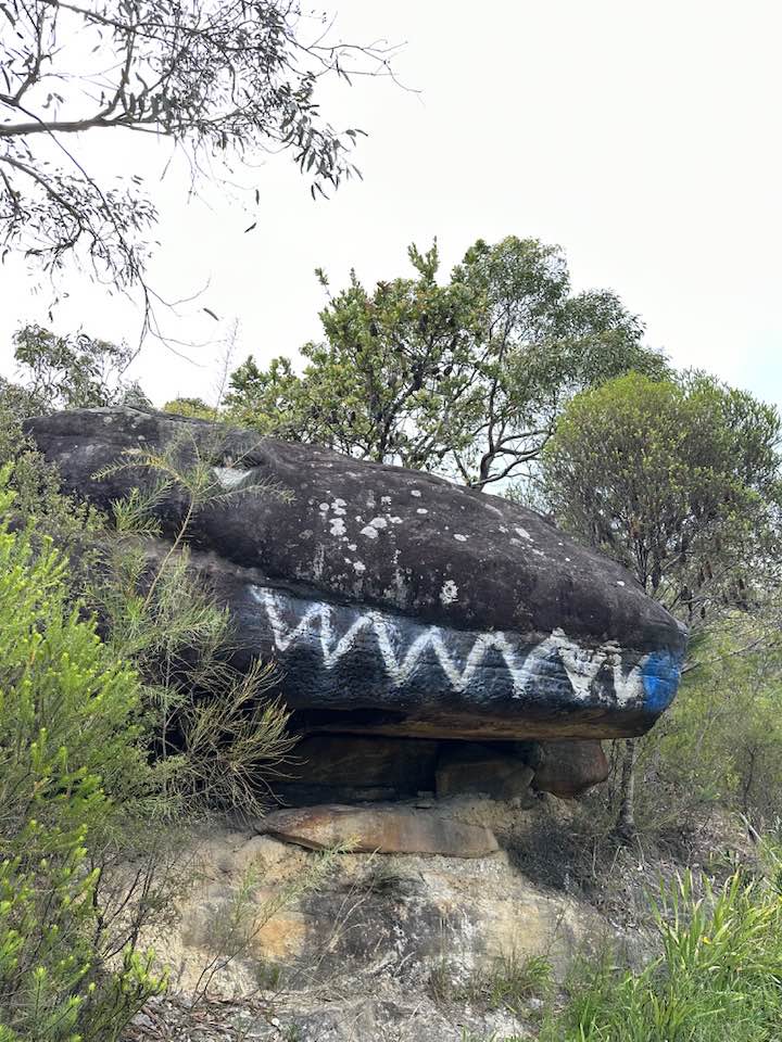
Neil explained to Pittwater Online he saw Aboriginal engravings of a kangaroo, and mundoes (footprints).
On the obverse the land councils reference the NSW Aboriginal Land Rights Act 1983 (as amended) which states that to be a member of a Local Aboriginal Land Council (LALC), you must be an Aboriginal person. Some state that there are 'illegitimate people who claim to be aboriginal’ but have never proved their claims, ancestral connections or traditional linkages to country in accordance with legal requirements, and so the land councils elevate the confirmation through a Native Title determination.
A determination of native title is a decision by the Court whether or not native title exists in relation to a particular area of land or waters. If the Court decides that native title does exist it will also make decisions about: who the people are who hold native title common or group rights. An expensive process.
Land Councils will also go to court for a determination that Native Title does not exist in relation to land and waters identified.
Government agencies and community organisations usually accept three ‘working criteria’ as confirmation of Aboriginal or Torres Strait Islander heritage. These are:
- being of Aboriginal or Torres Strait Islander descent
- identifying as an Aboriginal or Torres Strait Islander person
- being accepted as such by the community in which you live, or formerly lived
' It is a sad reflection that the best known of the genuinely 'Sydney' families, like Waterer's, can follow their genealogies to 1788, even beyond. Such are the descendants of Bungaree, Matora, Maria Locke and Peggy Reid. Each woman married a convict and attracted much white attention at the time. The descent of the many Aborigines who did not marry, or simply bore children to whites before 1830, remains obscure. It is these hundreds--no, thousands--of unfortunate people whose identity is daily and nosily challenged by non-Indigenous people and, increasingly, other Aborigines of the Sydney basin.' [1.]
Northern Beaches Council held an extraordinary Meeting at 10am on Tuesday January 24th at which it confirmed it would reject an offer to be the Planning Proposal Authority for a plan that would see more than 400 homes constructed in bushfire-prone land.
The Council has long opposed the planning proposal to develop land at ‘Lizard Rock’ along Morgan Road in Belrose for its destruction of natural bushland among a range of other concerns.
Northern Beaches Mayor Michael Regan said the planning proposal by Metropolitan Local Aboriginal Land Council (MLALC) does not demonstrate strategic or site-specific merit and should be rejected.
“Council refuses to be involved in the progression of this planning proposal that would see more than 400 homes built in precious bushland, putting residents in extreme bushfire risk,” Mayor Regan said.
“As I’ve repeatedly said, Council one hundred percent supports the intent of the Aboriginal Land Rights Act and appreciates the importance of enabling Aboriginal people to achieve economic self-determination through developing land, but we have to consider proposals on their merits.”
In April 2022, following a Council Resolution, Council wrote to Federal and State MPs and relevant ministers to negotiate an alternate solution and financial model so that the MLALC can benefit financially from its land and that the land is preserved as is – in perpetuity.
“It’s absurd that the government would allow the destruction of around 45 football size fields of bushland to build 400 plus homes surplus to any housing targets,” Mayor Regan said.
“We are declining the government’s offer to become the Planning Proposal Authority on Lizard Rock as the role is unlikely to give Council any meaningful powers to review the proposal or prevent it from going ahead for Gateway determination.”
In its submission to the Department of Planning and Environment, Council warned that the planning proposal is inconsistent with local and regional planning strategies and should be reconsidered in light of significant planning, environmental and hazard issues, including:
- Bushfire risks – significant concerns exist regarding the bushfire hazard that applies to the site. Further, the proposal was developed on the premise of evacuation being provided by Morgan Road, a new slip lane onto Forest Way, and a new emergency access on to Oates Place, but the availability and utility of these aspects has not been demonstrated.
- Inconsistency with strategy – the planning proposal does not demonstrate strategic merit and is inconsistent with key aspects of the Greater Sydney Region Plan, North District Plan, Northern Beaches Local Strategic Planning Statement – Towards 2040 and Northern Beaches Local Housing Strategy.
- Non-compliant process – there has been no formal pre-lodgement consultation with Council on the planning proposal which is required in this circumstance
- Short consultation timeframe – the 28-day timeframe to review the application and associated technical reports for a complex proposal and prepare a meaningful response is unreasonable
- Inconsistency with Conservation Zones Reform which recommends applying a C3 Environmental Management Zone to most of the site due to its high environmental value and the hazards that impact the site
- Enormous loss of high biodiversity habitat, with 44.7 hectares of bushland to be cleared (equivalent to the size of around 45 rugby fields) for the new development.
Mayor Regan said there has been limited explanation from the State Government on how the Sydney North Strategic Planning Panel came to the decision to submit the planning proposal for a Gateway determination.
“The community has really been left in the dark as to why and how this proposal is going ahead,” Mayor Regan said.
“There’s been no detailed justification as to how the Panel reached its conclusion and no meaningful discussion on the concerns and issues that Council and the community has repeatedly raised.
“We strongly urge the government to reconsider its position on a planning proposal that just doesn’t stack up.”
Council stated it will notify the Planning Panels Secretariat that it is declining the offer to be the Planning Proposal Authority.
The Department of Planning webpage for the Lizard Rock Development was updated the next day, January 25th, to reflect Council's decision, and now states:
In December, Northern Beaches Council was offered the opportunity to accept the planning proposal authority role, to prepare the planning proposal for Gateway determination by the department.
The council has declined the role. The panel will now appoint itself as the alternate planning proposal authority.
If the proposal proceeds, it will be publicly exhibited for a minimum of 28 days in 2023, giving the community and other stakeholders the opportunity to provide feedback.
For more information on the Gateway determination process, please see Making and Amending LEPs.
Background
The department received a planning proposal for the Lizard Rock site, on Morgan Road, Belrose (the proposal) in October 2022. The proposal was submitted by GYDE Consulting on behalf of the Metropolitan Local Aboriginal Land Council (MLALC).
The department prepared a report for independent review by the Sydney North Strategic Planning Panel (the panel). The report included comments received from Northern Beaches Council.
The panel determined on 21 December 2022, that the proposal should be submitted for a Gateway determination.
- Advisory Entities (including Boards and Committees)
- Departments
- Executive agencies related to Departments
- Separate agencies
- State Owned Corporations
- Statutory Authorities/Bodies
- Subsidiaries of the NSW Government established under the Corporations Act
- The number of dwellings is to be capped at 450;
- 10% affordable housing is to be provided;
- The final zoning arrangements and boundaries are to be resolved to maximise the retention of important biodiversity values; and
- A site specific DCP, to guide future development to deliver on the objectives and intended outcomes of the Proposal, is to be finalised in consultation with Council and the Department before exhibition of the planning proposal.
- a decision to write to the NSPP requesting more detailed reasoning on each of the issues raised by the NBC in its submission to the NSW Planning and Environment Department on November 24 (from Your Northern Beaches Manly Councilor Sarah Grattan).
- reiterating council’s strong opposition to the planning proposal in writing to the NSW Premier and the NSW Leader of the Opposition to seek their support to overturn the decision.
- asking the NBC CEO and the Mayor to request meetings with the NSW Premier, NSW Leader of the Opposition to oppose the development (my suggestions) and to request a meeting with the NSW Aboriginal Affairs Minister to discuss supporting alternatives with the Aboriginal Land Council for different solutions (from Ms Heins).
‘Singing up Country’: reawakening the Black Duck Songline, across 300km in Australia’s southeast
Aboriginal and Torres Strait Islander readers are advised this article contains names of people who have died.
Songlines criss-cross across Australia. They are one of the foundational spiritual features of the world’s oldest continuing culture.
Australian Aboriginal peoples had oral cultures: while there are no Bibles or Qurans to document their spirituality, the Dreaming stories of Ancestral creators who formed the land and the features were shared through song. By walking and singing the songlines, those creators are celebrated by the passing generations.
Most of our knowledge of songlines comes from Aboriginal peoples in central and northern Australia, a well-known example being the Seven Sisters Songline, which crosses much of Australia from the west coast to the east.
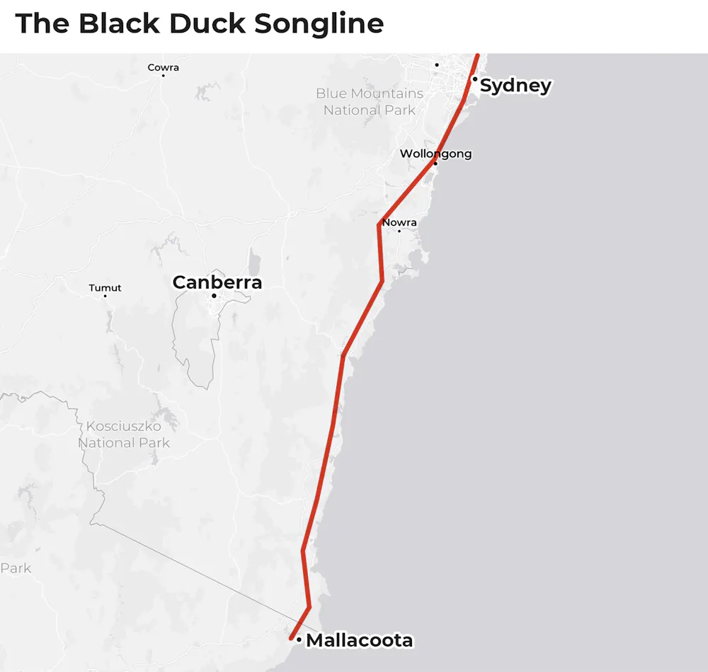
But, due to invasion and attempted cultural destruction since 1788, knowledge of songlines in southeast Australia has been limited. Now, new research has begun reawakening a dormant Black Duck Songline covering 300 km along the New South Wales South Coast.
Umbarra and Wumbarra
The Black Duck Songline, as current Aboriginal knowledge holders confirm, travels up the South Coast from over the Victorian border to the Hawkesbury River, north of Sydney, passing through many important cultural locations of the Yuin and Dharawal peoples of the region.
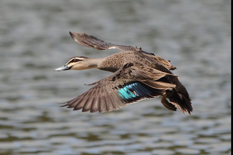
The name comes from the Pacific Black Duck (Anas superciliosa), known as Umbarra to the Yuin and Wumbarra to the Dharawal.
The Yuin story of Umbarra comes from Wallaga Lake near Narooma on the NSW far south coast. Umbarra is an animal hero, rather than a Creator, and is the totem and protector of the Yuin peoples from the Dreaming.
A Yuin man, Merriman, had Umbarra as his totem. When his people were in danger, Umbarra warned them so they could take refuge on what is now called Merriman’s Island in Wallaga Lake.
Umbarra became the Yuin protector, and, through kinship linkages, the bird is equally important to the Dharawal.
One of the authors of this piece, Robert Fuller, was exploring the astronomy and songline connections of the Saltwater Aboriginal peoples of the NSW coast. Through a yarning process, speaking to Yuin and Dharawal knowledge holders about the cultural astronomy of their communities, the importance of Umbarra to the Yuin peoples became clear, as did the route of the songline.
The Black Duck Songline has now been traced through multiple Aboriginal communities. Knowledge holders speak about how their people travelled along songlines for trade, to attend ceremonies and to access resources.
How a songline is reawakened
A songline is not just a map across Country.
It is a celebration of the stories which make up the songline, and these stories are encompassed in the form of song. The melody stays consistent as a songline passes through different language groups and dialects along the route.
A songline is never extinguished, although the Country through which it passes may be dying because it is not being sung. This has given rise to the Aboriginal expression to “sing up Country”: refreshing the songs and the Country to which the songs belong.
The Black Duck Songline was not unknown to the knowledge holders of the South Coast, but the details of the route had begun to be lost. Probably the last public walk of the songline was by Uncle Guboo Ted Thomas (1909-2002), coinciding with the Bicentennial in 1988.
Other knowledge holders who learned from Uncle Guboo have been able to confirm details of the songline, and members of the Yuin and Dharawal communities are keen to recover the full knowledge of the route of the songline.
After the Hawkesbury River, it is possible the Black Duck Songline may continue north, eventually turning west and south, via the Narran Lakes and the Snowy Mountains, connecting with its origin on the Gippsland Coast, forming a circle.
The major focus of the reawakening of the songline will be to find the songs that make up the story and try and connect them in the correct sequence and with the correct spiritual locations along its route.
If the Black Duck Songline can be awakened, this could be a model for the recovery and reawakening of other songlines in areas of Australia where Aboriginal knowledge has been suppressed.![]()
Robert S. Fuller, Adjunct fellow, Western Sydney University; Graham Moore, Yuin Elder, Indigenous Knowledge, and Jodi Edwards, Tutor, Faculty of Arts and Social Sciences, University of Sydney
This article is republished from The Conversation under a Creative Commons license. Read the original article.