A few weeks ago the news service was fortunate to run a few insights from Beverlie Farrelly on her husband Bernard, known as 'Midget', the first World Surfing Champion.
Beverlie shared that her first home in Pittwater was when her family lived in Avalon Camping Ground after Wold War Two.
This prompted a few inquiries from younger readers and new arrivals to Pittwater who were not be aware that the green area behind Avalon Beach dunes was once a vey popular camping ground from the late 1920's to 1930's on, until Warringah Shire Council closed it in 1953.
Although the closure in 1953 could be attributed to flooding that occurred in May that year, with two severe rain events within two days washing campers and their possessions along the Careel Creek into Careel Bay - and may wonder about the wisdom of allowing a camping area in what was known to be a flood zone to begin with - during the few decades it existed it provided not only a place to live for those impacted by the 1930's economic depression - when many took to canvas and caves to provide a roof for loved ones, and headed beachwards where they could fish for food - and persisted in post World War Two shortages - it also brought people to our area who stayed and not only went on to build community and serve in its volunteer organisations - such as the surf club - they helped establish the 'there's no them and us, it's just us and us looking after us' mien of the Barrenjoey community that persists today.
With new materials and photos found since that first page on Avalon Camping Grounds ran, and the council recently completing works at the north end of Hitchcock Park to ensure a better flow for the Bangalley creeks - more on that as soon as the Crown Land Grants for 2025 are announced, along with a history page on those North Avalon Creeks - a refresh for those who weren't around when the peninsula was still mainly a holiday resort, and a Summer under canvas became a way to live permanently as our nation recovered from a series of challenges.
The first element to acknowledge in allowing a camp site on the area alongside Careel Creek is that his had been known as a mangrove wetland and by the name 'Priest's Flat' since Europeans occupied the area.
Charles De Boos, in his work 'My Holiday' which shares his and a friends trek from Manly to Barrenjoey by foot during the mid 1860's, describes, on emerging from walking down into, then back out of Bilgola beach:
Suddenly, however, the road took a curve round to the left, crossed a knoll of the range, and then swept down, in some fifty different tracks, on to a broad swampy plain, or flat, which seemed to us to be inundated, for we could see the water sparkling and glistening in the sun over its whole face. I pulled up short here.
" It won't do to go down there, Tom," said I.
"Oh, but we must," he replied. "This is the Priest's Flat, and there, where you see those shears erected, with the two tents alongside of them, is where they are boring for coal. We must go and report progress."
I looked ruefully at Nat, who made no reply, but, grinning viciously, bent down and turned up his trousers to the knees.
“Do you think there are any leeches there ?” I asked. Nat's trousers were instantly turned down again, and this time he didn't grin,
"Oh, no," Tom answered, "there's too much water there for them, and not enough shelter.
I was easier in my mind, though I had my misgivings; but as these Antipodean leeches seemed to be ruled by laws, and to have amongst themselves habits and customs totally at variance with those of leeches in civilised communities, possibly Tom might be correct; so, tucking up my trousers, I prepared to descend. And, after all, when we got down to the flat it was not so bad as it had appeared to us from the hill. The ground was somewhat honeycombed and the water lay in pools, between which however, we managed to find sufficient footing without actually walking in water.
Arrived at the tents, warning of our approach was given by a solitary dejected bark, ending in a melancholy and prolonged howl, from some unseen dog, that was evidently too broken down and low-spirited to repeat the challenge and it was only after we had approached the shears, and had commenced our examination of the boring, which, to tell truth, none of us could make head or tail of, that a tall sailor looking man, who appeared as if he had but just that instant been uncoiled full-rigged from between the blankets, came out to the entrance of one of the tents, and regarded us with an air of blank and sleepy astonishment. Just after him followed his watchful canine guardian, whose short bark and long ululation had effected his master's awakening, but so far behind as not to be within kicking distance; his cowering watchful look, and his tail hard down between his legs, evidently saying as plain as could be said, " I don't know whether I have done right, so I must stand by for squalls."
It took a good deal to waken up our friend to a full sense of the information we required from him, and it was only by the casual mention of Farrell's name that he was brought to his full mental perceptions. A grin spread over his countenance when we said where we had just come from.
“Did you go candling with him ?" he asked. We explained how it was that we had not done so.'
“Oh, isn't it prime fun !" He was fast getting lively.
He had been of the party the night before our arrival, had got wet through, had disported himself like a grampus in the pool, and had got home with an exulted notion of the sport. Of course we did not undeceive him; but having now got him up to the proper communicative pitch, we proceeded to worm out of him, by dint of much questioning, and much labour in bringing him back to the subject in hand for he would insist upon darting off from it at a tangent to give us collateral evidence upon matters in which we had not the slightest interest-all that he knew of the boring.
From the information thus acquired, as well as from enquiries subsequently made, I learnt that the spot now being bored was about the centre of a very fine property of some 1200 acres in area, granted many years ago to the Rev. Father Therry, and extending across the Barranjuee peninsula from the shores of the Atlantic to those of Creel Bay; the one being its eastern, the other its western boundary. Hence the plain had been christened the Priest's Flat.
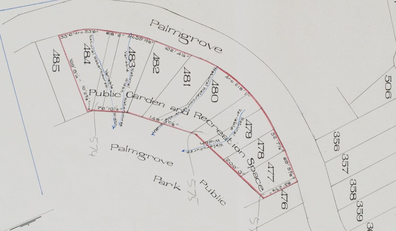
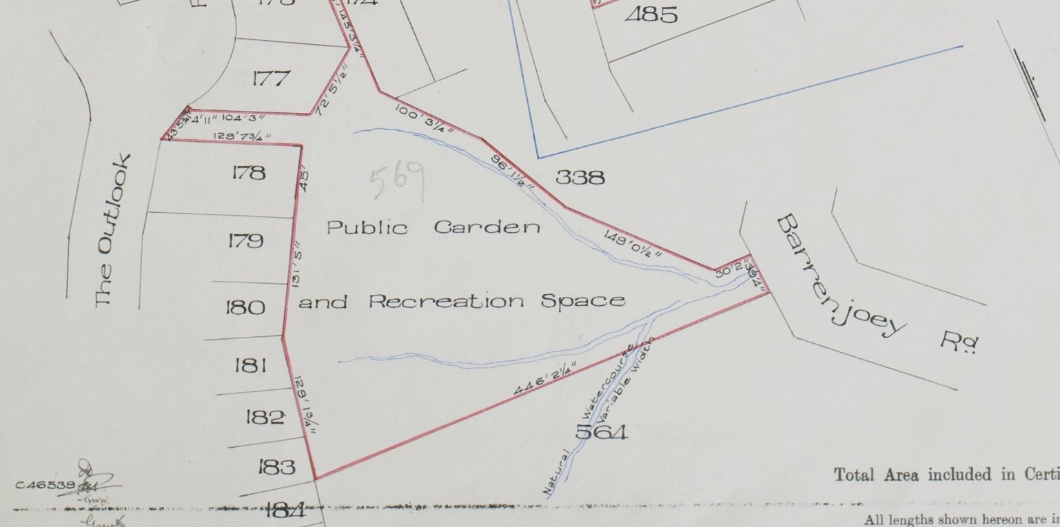
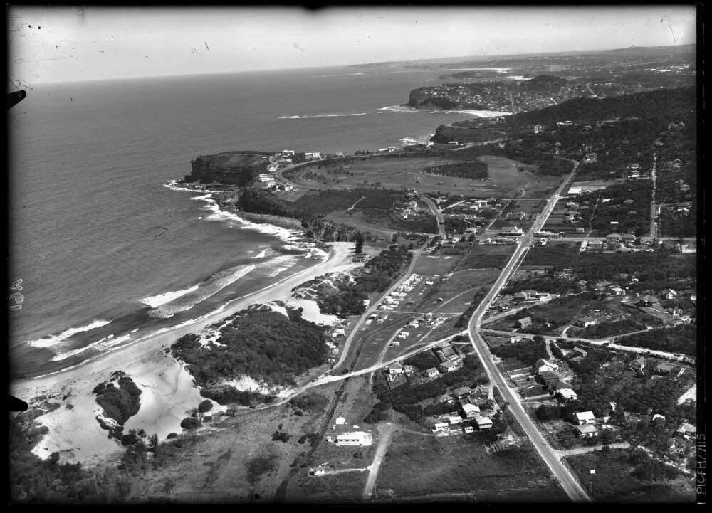
Even the earliest lithographs for land subdivisions show the extension of this floodplain from the edge of North Avalon Beach right into Careel Bay:
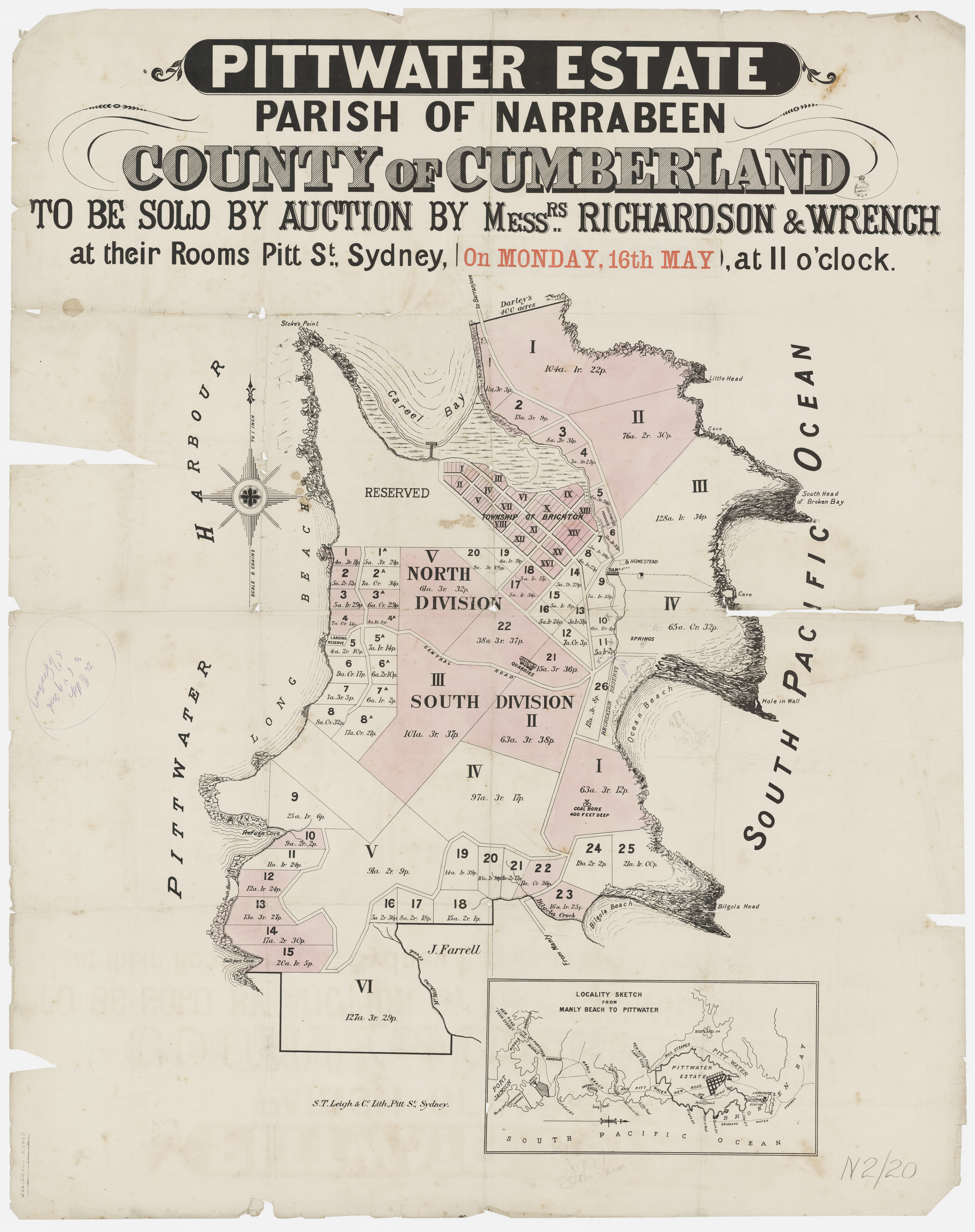
Pittwater Estate Monday May 16th, 1881 - Richardson and Wrench - Item c050370020, courtesy State Library of New South Wales - and section from:
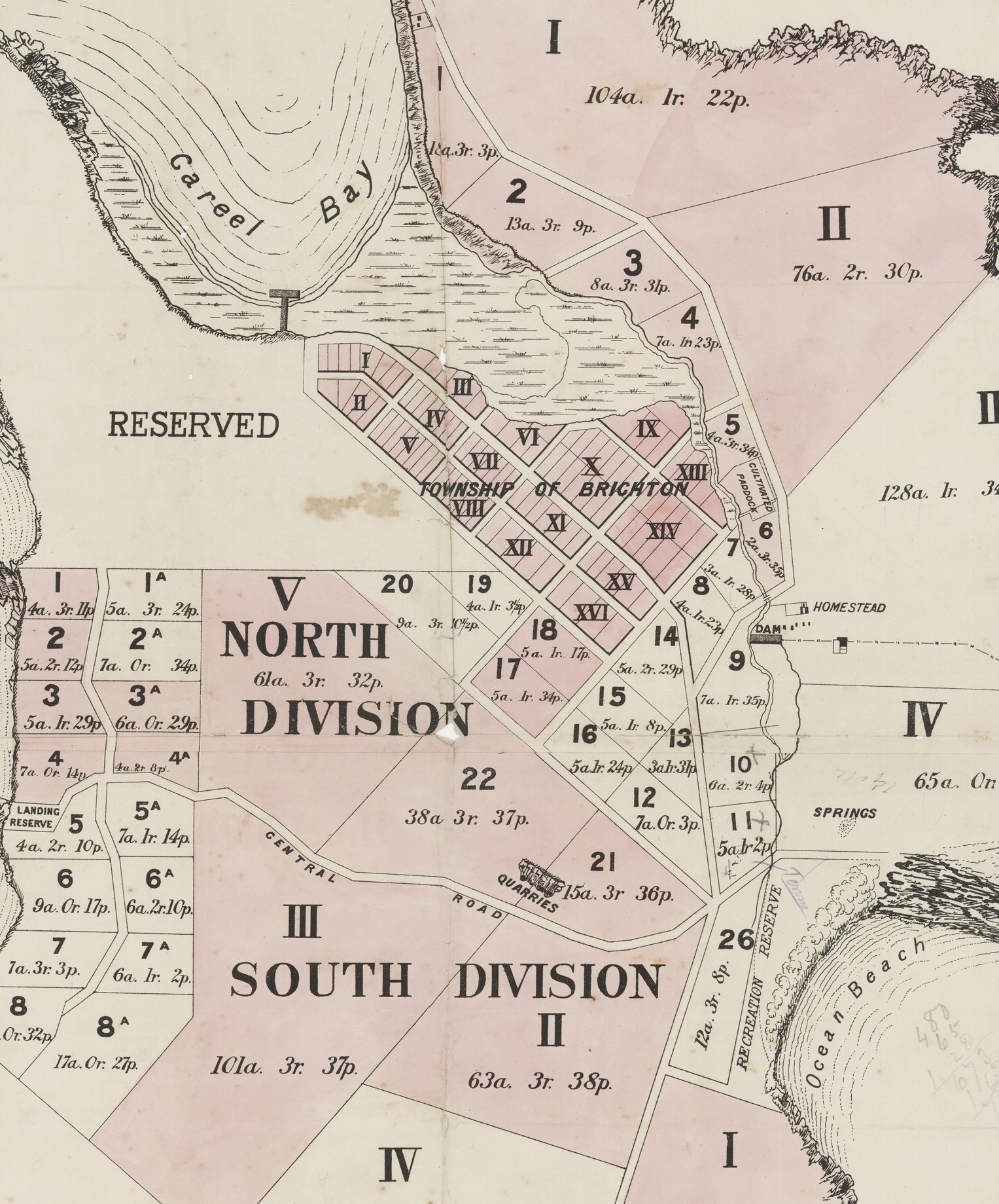
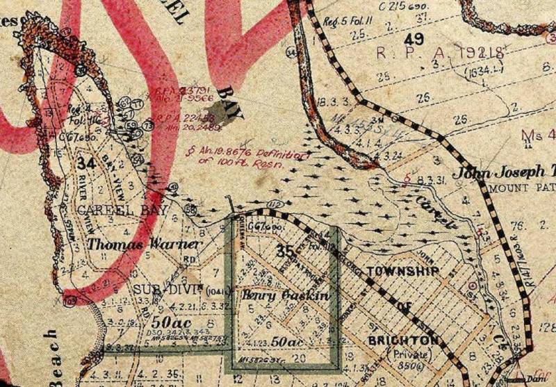
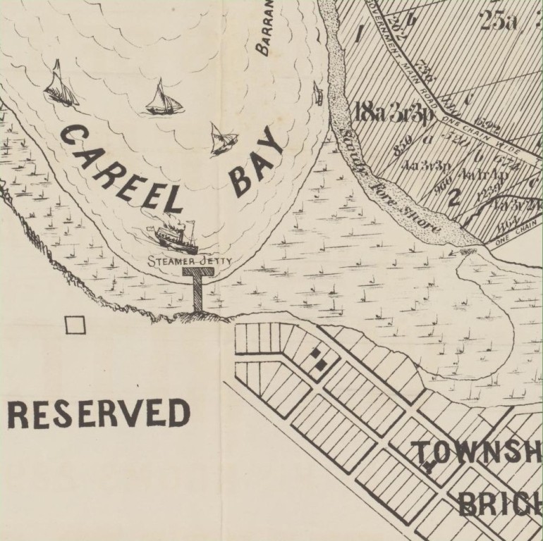
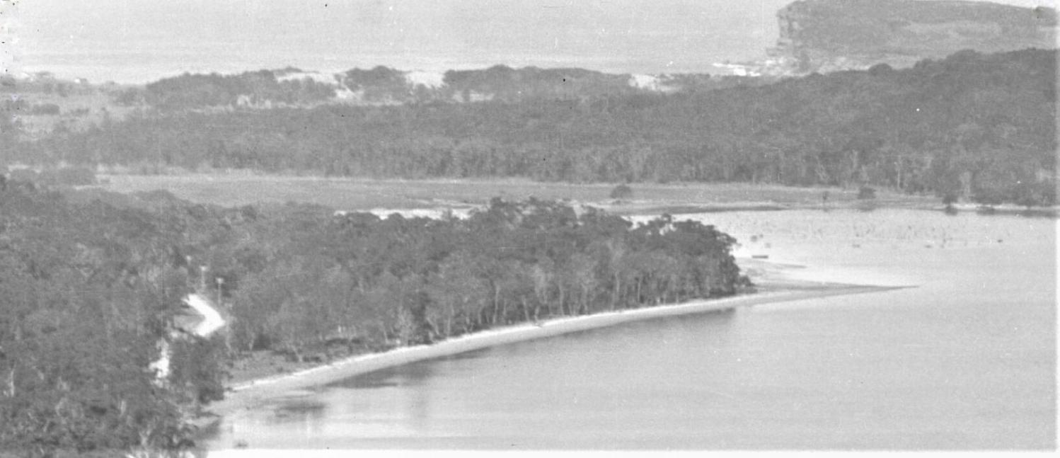
Photos sourced for the Careel Bay Playing Fields Reserve - Including Hitchcock Park: Birds, Boots & Beauty History page, for those unaware that both the Careel Bay playing Fields and Hitchcock Park are reclaimed mangroves, despite the lithograph above showing the extent of the mangroves, give some inkling of the extent of the wetlands prior to those areas being used as a tip s part of that process - which commenced soon after the camping grounds were closed:
An early Verrills-Gonsalves photo from the ground level a Careel Bay looking east shows:
And just behind he dunes in the early 1920's - with cars with some tents already visible on the edge of south Avalon Beach:
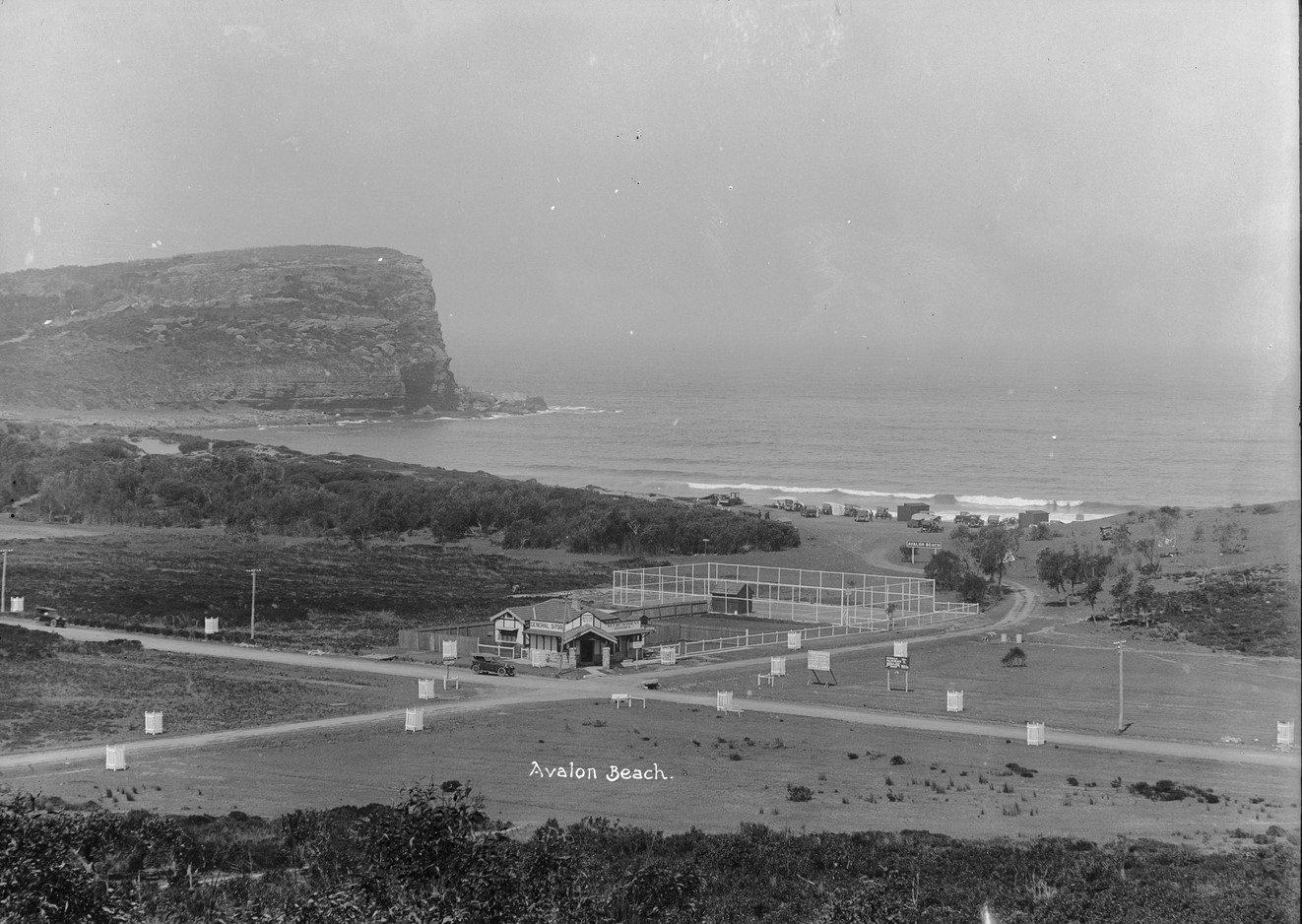
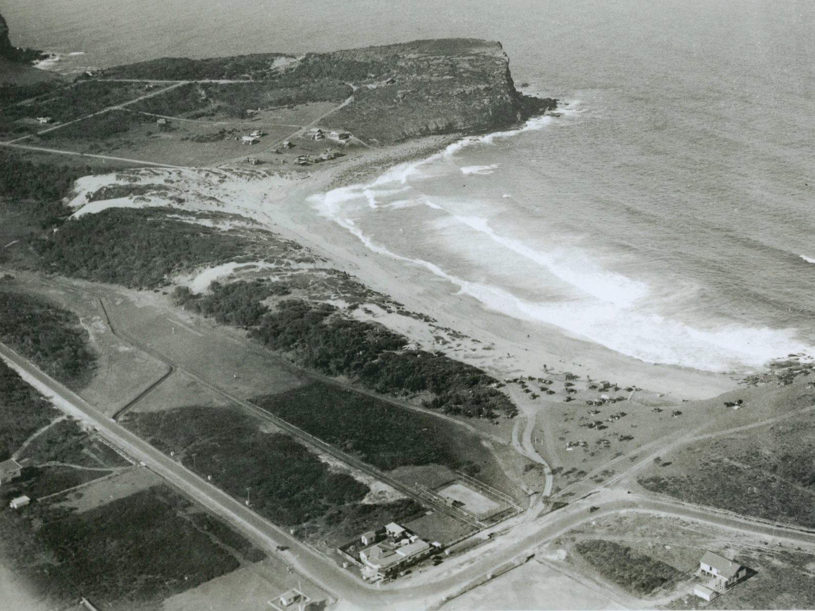
Before A J Small opened the ‘Avalon Beach Private Pioneer and Camping Grounds’ or the Avalon Picnic Grounds operated on what is now the green area where the ‘yellow brick road’ or path wends behind Avalon Dunes, others who came to the area lived under canvas and off the fat of the land.
Alexander Stewart Jolly in the book he wrote for his children, ‘The Spirit of the Bush’ speaks of eating oysters from Careel Bay and an abundance of other seafoods. This gentleman was renowned for camping on the blocks of land where he would build some of our more famous and quirky houses.
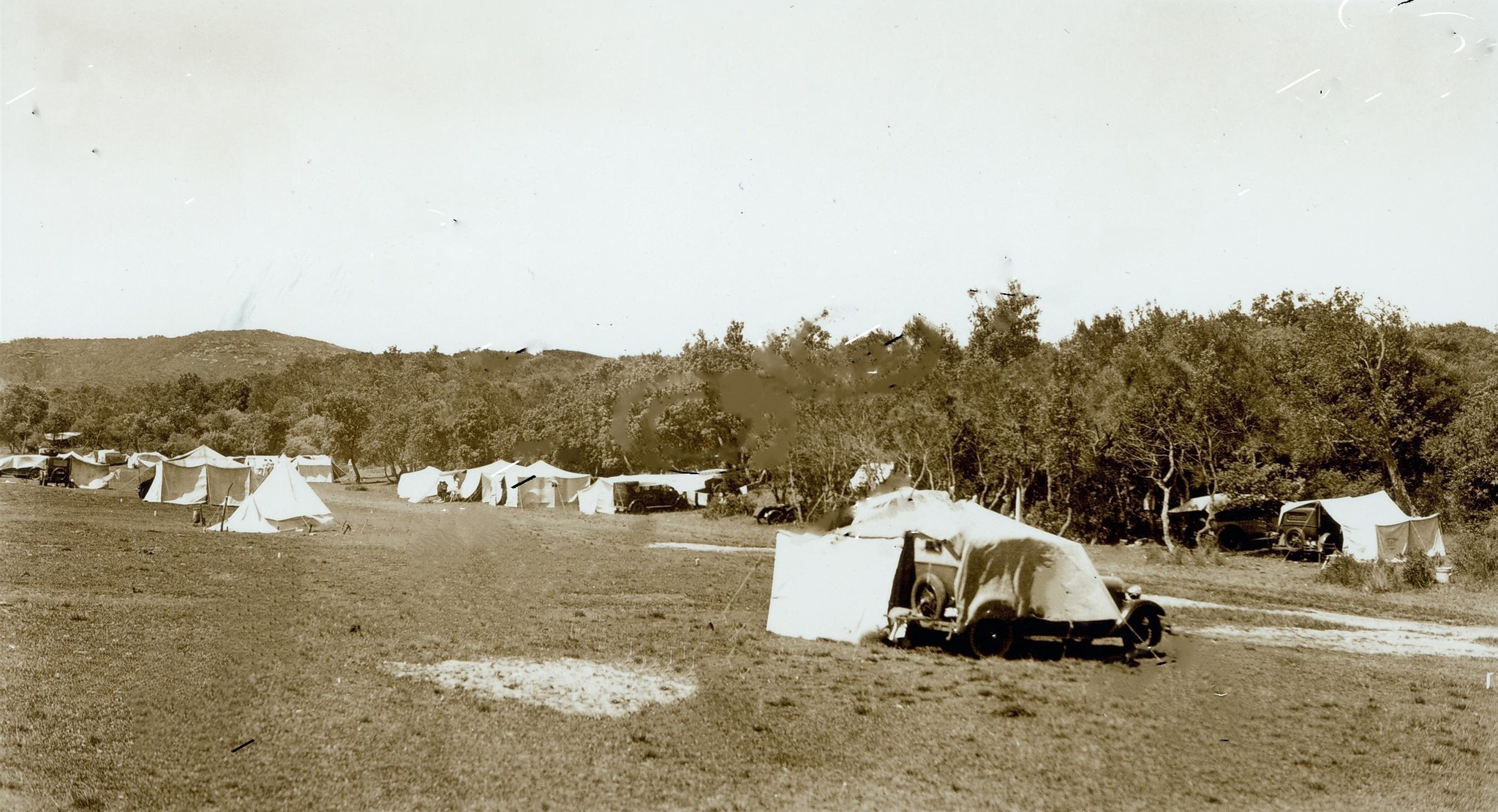
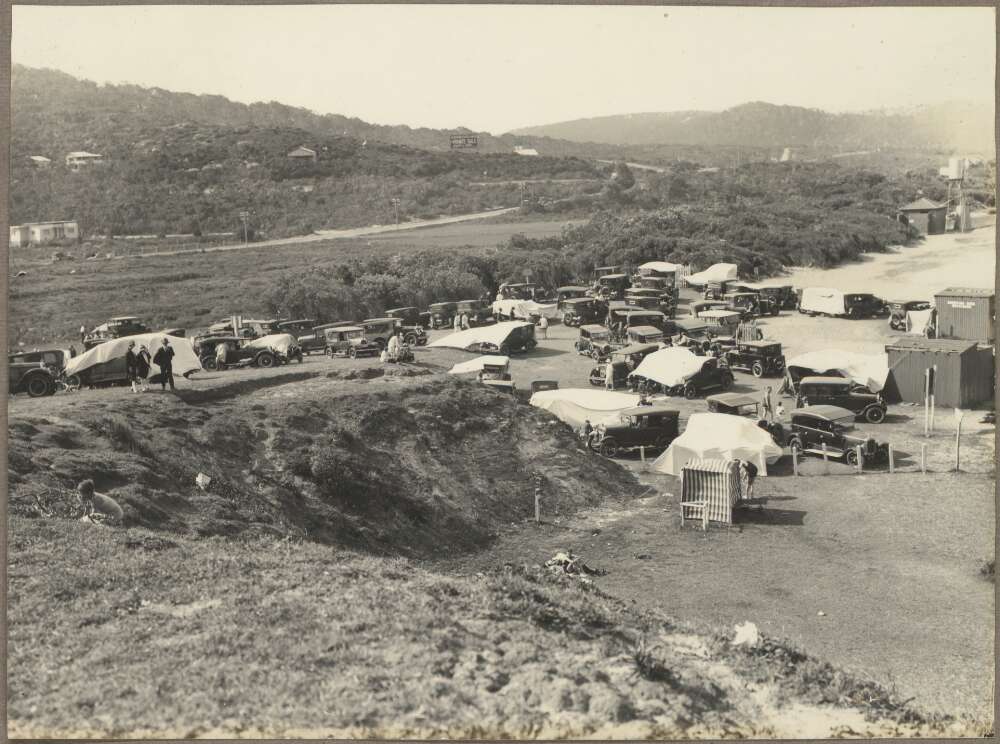
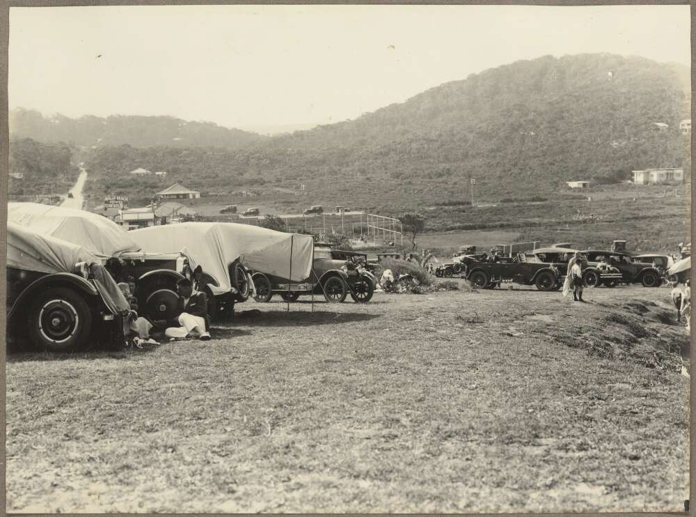
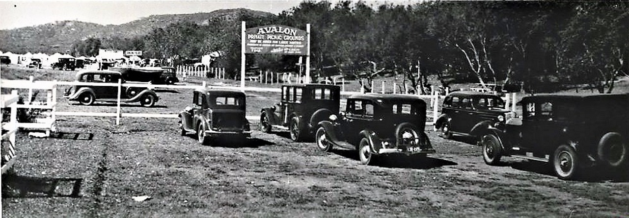
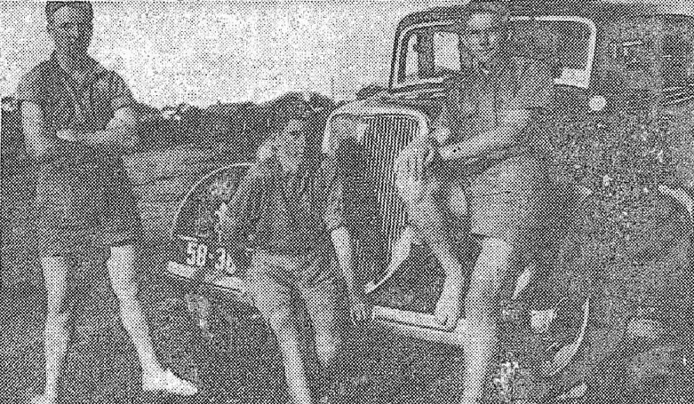
Throughout the 1920's and into the 1930's a popular holiday or weekend away was the 'motoring camping holiday', where people, as can be seen below, would install makeshift shades and canvases over their vehicles.
LE "MOTOR CAMPING OUT.'
Monte Luke, le célèbre artiste photographe de Sydney, Madame Monte Luke et leur famille à Avalon Beach, près Sydney. LE "MOTOR CAMPING OUT." (1928, October 26). Le Courrier Australien (Sydney, NSW : 1892 - 2011), , p. 3. Retrieved from http://nla.gov.au/nla.news-article161724364
Avalon Camping Reserve, circa 1929-1934. Image: PON records/Editor's old Postcards/photos collection
(circa 1930). [Motor cars, some with tarpaulins attached, parked adjacent to Avalon Beach, New South Wales, 1930, 2] Retrieved from http://nla.gov.au/nla.obj-147290238 - shows the road running north in the background and dressing sheds on the beach. Part of Prospectus photographs of Avalon, 1930 [album], courtesy National Library of Australia.
.jpg?timestamp=1619640573517)
(1930). [Motor cars, some with tarpaulins attached, parked adjacent to Avalon Beach, New South Wales, 1930, 1] Retrieved from http://nla.gov.au/nla.obj-147290036 - and enlarged section from to show the Central Avalon Village Recreation Reserve as it was then and known as Dunbar Park today - more in: Avalon's Village Green: Avalon Park Becomes Dunbar Park - some history + Toongari Reserve and Catalpa Reserve and Pittwater Beach Reserves have been dedicated for public use since 1887 - no 1.: avalon beach reserve- Bequeathed by John Therry and Pittwater Roads II: Where The Streets Have Your Name - Avalon Beach
Alexander Stewart Jolly came to Avalon early in the Depression era, exhausted by working in the city and one of those who was poor. The Depression in Australia, stated by some to have reached its peak in 1932, caused many to construct crude dwellings or pitch permanent tents along the whole of the Australian eastern coastline where they could live without paying unaffordable rents and feed families with what they could catch from the sea or glean from the shorelines. Many of the 33 yard pools built on the Northern Beaches coast during this period were constructed by unemployed folk. There were also road building programs and many of what were termed 'Unemployed Camps'. Some of these folk sought to make a few pennies to buy bread or flour to make bread from selling fish caught, not always without heaping tragedy upon tragedy;
SWEPT OFF ROCKS. Fisherman Drowned.
James Wise, an unemployed carrier, was swept from the rocks at Avalon on Saturday and despite the attempts of a friend to save him was drowned wise, with his wife and three children, was camping at Pittwater, and was earning his living by fishing. With another man, James Williams, he was fishing on Saturday off the rocks at Avalon at a spot called "The Hole in the Wall " The sea was rising, and waves were breaking over the men, and Williams suggested that they should move to a higher place. Before Wise could move, a wave swept him away Williams swam out, and struggled to bring Wise ashore for almost 20 minutes A wave separated them, and Williams was too exhausted to succeed in another attempt at rescue. Narrabeen police were informed of the tragedy, but the body had not been recovered up to last night. SWEPT OFF ROCKS. (1932, November 28). The Sydney Morning Herald (NSW : 1842 - 1954), p. 9. Retrieved from http://nla.gov.au/nla.news-article16933805
The November 5th 1934 Minutes of a Warringah Shire Council Meeting record:
Item: 25. A.J.Small 26/10/34, stating he is repeatedly receiving requests for permission to camp on his property at Avalon Beach, suggesting the Council make a flat charge of, say, up to £5 per annum, for camping on Lot 26 and Lots 3 and 4, Avalon Beach, he being prepared to erect sanitary accommodation to any reasonable extent, and have the camping area properly run and supervised; that N.R.M.A. officials have inspected the camping area, and are prepared to support the proposal; inquiring whether if such camp be established, the Council would prevent the indiscriminate camping on adjacent public roads and reserves, and by trespassers on private property. Resolved, - That the proposal be approved on the condition suggested by the Inspector, viz - that three earth closets be provided for men, and three for ladies, and Mr. Small arrange direct with the sanitary Contractor for adequate sanitary services, and pay him direct for same; that a notice be erected in a suitable position prohibiting camping on the roads and reserves. (Crs. Hitchcock, Hughes)
MOTOR CAMP AT AVALON
The N-R-MA has made arrangements for establishing a summer motor camp at Avalon Beach, 22 miles from Sydney, between Narrabeen and Palm Beach. There is a fine surf beach at 'Avalon, and a nine hole golf course, on which members of the association are entitled to play at a reduced fee. A tennis court is situated nearby. All stores and petrol supplies may be obtained at Avalon. Full details of the camp may be obtained from the N-R MA. Touring Department. MOTOR CAMP AT AVALON (1934, November 29). Glen Innes Examiner (NSW : 1908 - 1954), p. 9. Retrieved from http://nla.gov.au/nla.news-article183575064
For others a vestige of dignity is restored in ‘having a holiday’ rather then being among those who have no other option in the rising popularity of the ‘Motor Camp’, cars being a then popular refuge for the homeless:
Narrabeen, Avalon, and other havens on the coast presented a remarkable sight. The popularity of the motor camp has increased enormously in recent years, and hundreds of cars were parked at these places. The motorist has received every assistance and encouragement from municipal authorities to spend a holiday in this manner, and the response has exceeded all expectations. Thus, many thousands of people can feel accounted for they are spending their holiday under canvas beside their cars. The CITY RELAXES. (1934, December 27). The Sydney Morning Herald, p. 8 Supplement: Women's Supplement. Retrieved from http://nla.gov.au/nla.news-article17135091
The Warringah Shire Council Meeting held on February 5th 1935 shows a letter from George Killigrew Dunbar among the records: Item 34. G. K. Dunbar, 25/1/35, re: lack Of public parklands adjacent to Avalon Beach, and the fencing off of private land adjoining the Beach reserve, and contending the latter land should be resumed by the Council before the owner puts more improvements on it. Received. A.E. Felton, 28/1/35, contending that camping on the Bilgola reserve at Bilgola Beach should not be prohibited, agreeing that the area becomes congested, suggesting there be on one line of tents permitted, with a 3-ft. space between them: Resolved, - That the Council's previous decision to prohibit camping on the reserve be agreed, and the Inspector see that it is carried out. (Crs. Hewitt, Hughes)
National Roads & Motorists Assoc., 21/2/35, pointing but that persons camping on the public reserve at Avalon Beach pass through the section of Mr. Small’s ground used by N.R.M.A. members, requesting the Council to give its attention to this matter before the Easter holidays. Resolved, -That the matter be left to A. Riding Councillors. 63. A.J.Small, 2712/35, re camping on Avalon Beach Reserve, taking exception to a recent report by the Inspector on the matter, explaining the position, and requesting a definite statement of the Council's intention in regard to allowing camping on the beach reserve. Cr. Hughes moved, Cr. Hewitt seconding, that the Inspector should not have made the remarks concerning Mr. Small which he made in recent report to the Council. Cr. Campbell moved an amendment, Cr. Beello seconding, that consideration of the letter be deferred until the Inspector returns from holidays. The amendment was carried.
At the Tuesday 7th of April, 1936 Council Meeting:
Avalon Beach & District Ratepayer's Assoc., 23/3/36, advising Council of the formation of the Association. "Received". National Roads & Motorists Assoc., 26/3/36, advocating for the resumption of the whole of the flat area between the beach reserve and Barrenjoey Road at Avalon, as the ground is admirably suited for camping, picnicking and parking. Extension - The Association be informed the Council is taking all necessary steps to resume the land.
Soon afterwards it was reported in the newspapers of then:
The Warringah Shire Council has advised the N.R.M.A. that action Is to be taken to effect the resumption of the whole land between Avalon Beach Reserve and Old Barrenjoey Road, with the exception of a rectangular portion at the Junction of Avalon Parade and Barrenjoey Road, on which a shop is situated. The association, when advocating the resumption, stated that the existing reserve is narrow and sandy, and does not offer facilities for car-parking. The area which it is proposed to resume is admirably suited for camping and picnicking. HAVE YOU HEARD? (1936, April 28). The Labor Daily (Sydney, NSW : 1924 - 1938), p. 8. Retrieved from http://nla.gov.au/nla.news-article237771798
Avalon Beach Reserve
THE Warringah Shire Council has advised the N.R.M.A. that action is to be taken to effect the resumption of the whole of the land between Avalon Beach reserve and the Old Barrenjoey road with the exception of a rectangular portion at the junction of Avalon Parade and Old Barrenjoey road, on which a shop is situated. The association, when advocating the resumption, pointed out that the existing reserve is narrow and sandy, and does not offer facilities for car parking. The area which it is proposed to resume is admirably suited for camping and picnicking. Avalon Beach Reserve (1936, May 13). Sydney Mail (NSW : 1912 - 1938), p. 44. Retrieved from http://nla.gov.au/nla.news-article160638679
This was still basic living, with weather and bushfires to contend with; At many places hoses were used to fight the fire. Water was connected to Avalon only a fortnight ago. (The Sydney Morning Herald, Friday 13 November 1936, page 10). By now many semi-permanent residents lived in this flat area behind the dunes, a paddock subject to flooding. Their children attended Newport School, often without the luxury of shoes.
Also worth noting from the same records as it illustrates people were camping anywhere they could during this era of low employment and homelessness - Item 40 from Warringah Shire Council's November 1936 Meeting records:
G. J. Brandon, 23/11/36, (a) reporting that a swagman or fisherman has taken possession of the small bathing shed, erected by voluntary workers on the reserve at the northern end of Scotland Island, has closed it against the residents, steals water from the residences in the locality, and has no sanitary arrangements; (b) reporting that the wire-netting on the baths has perished and the baths are no longer safe and requesting that the causeway loading to the wharf be repaired; and complaining that damage is being done to property on Scotland Island by wandering horses owned by a baker at Mona Vale. Council's Decisions:. (a) that the person referred to he notified to vacate the bathing shed immediately, (Crs. Hitchcock, Campbell); (b) that £5 be voted for repairing the bathing enclosure, and the Overseer be instructed to use heavy gauge wire for the purpose, (Crs. Hitchcock, Ross); (a) referred to the Overseer for report; (d) that the baker referred to be notified to remove his stock. From Scotland Island. 41. G. Damyon, 23/11/36, also complaining of the misuse of the bathing shed mentioned above, and of the condition of the causeway leading to the north wharf on Scotland Island..
At the September 7th 1937 Council Meeting: Avalon Beach and District Prog. Assn. 31.8.37 (a) Surf ., endorsing the application of the Surf Life Saving Club for additional accommodation, (b) urging that the matter of the disposal of storm-water at the junction of Avalon Parade and Barrenjoey Rd be expedited and stating that the whole of the land on the north and south side of Avalon Pde. and west of Barrenjoey Road was inundated with water on 26th ult., (c) drawing attention to damage done to the 40-acre reserve adjacent to the Plateau at Avalon, formerly "a beautiful Plateau area of bushland, with forest trees, wild flowers huge natural boulders", and now having the appearance of a "shell- stricken area", (a) requesting Council's support to a request to the Transport Department regarding alterations to the summer timetable, namely, that the service terminating at Newport at 5.23 p.m. be extended to Avalon Beach. Council's decisions: (a) The Association be informed Council will give consideration to this matter next' year; (b) the Association be informed that the Council is awaiting the Main Roads Department's approval to the proposed drainage improvement: (c)\referred to the Works Committee for report: Motor bus , () that the Council support the application to the Transport services Department. (Cr.Hewitt, Cr. Hitchcock). 19. A. J. Small, 28.8.37, inquiring when the Council intends to open the lane between Lots 21 and 22 Clareville Ocean Bch. Avalon Estate, Barrenjoey Road, Avalon, in accordance with the Lanes agreement between him and the Council; Resolved, - That he be informed of the Council's decision to make application for the closing of the lane. (Cr. Hitchcock, Cr. Campbell). 20.' R. F.Seaborn, 31.8.37, (a) strongly objecting to any proposal to close lane mentioned. above ,1.ánd stating he and Do. ' Mrs. N. Buchanan would take the necessary steps to protect their interests. Resolved, - That a similar reply be sent in this 'case. . ' . ' 21.Mrs. N.L.Webster, (a) inquiring why Council permitted so many garages to be built in the North Avalon district, and Garages used as dwellings, (b) requesting that steps be, taken during the Summer keep campers within the proper camping area, and not permit them to camp at Nth. Avalon where they leave the sites in a very unsanitary condition. Resolved, - That she be given a copy of the Inspector's report regarding this...
Post WWII Australia had a lot of army surplus equipment and a shortage of building supplies. When speaking to Norma Watt (whose father built Careel Bay Boatshed), Doreen Cherry and Doug Crane, both of whom had to hand build their own homes in Avalon, the prevalence of living in converted garages or tents and hunting around hard and long for building supplies, whether bricks or boards, some resorting to making their own, was a feature in both their reminiscences. Returning service personnel were eager to ‘get on with it’ and begin the kind of life World War Two had put on hold; they wanted to get married and start families, to have their own homes and went about doing so with the same gusto and nerve they’d applied to life during the war.
HOLIDAY AT AVALON
By BETTY CROZIER
Rising headlands, rolling sand hills, and depths of deep blue water 1 This was the lovely impression stamped on mv mind, as I rode away from Avalon, where I had spent a jolly holiday.
AS I live the past over again, I can see two happy girls running from the shade of a colorful umbrella, down the sands, into the coolness of gigantic waves. The breakers are tumbling in, bedecked in foamy white collars, and splashing, laughing people shriek, as the giants crash on top like thunderbolts. After a refreshing surf, the girls make their way shorewards, and, throwing on beach gowns, race home across the sandhills.
Now they have come to the gate of their small cream cottage, where a cat is sleeping peacefully on the threshold, purring loudly. But, though so close to a beautiful beach, Avalon presents another picture, and the two young holiday-makers are wont to seek for adventure In a new field.
They start out by another door, to be confronted by miles of flat paddocks, broken by towering hills In the distance. Two pairs- of eyes are sparkling with excitement, for right in front of them are numbers of horses grazing contentedly under the trees.
Conquering their first fears, they gamely mount the bare-backed horses and, gaining confidence, ride away over the worn earthen tracks. Up, up the hill they go, and halt, to watch the water lashing angrily on the rocks below. Far out in the blue Pacific they see great ocean liners passing, bound for lands, who knows where? Then, turning In their tracks, they have races across country, enjoying the fresh air of the wide open spaces.
For a long time thus they ride, loving every moment. They return at last along a pebbly road. They enjoy a healthy meal, and happily tumble into bed, to think of the fresh joys to-morrow holds in store for them.
(Purple Certificate to Betty Crozier, E.S.W. (14), 14 Mitchell-street, Greenwich. HOLIDAY AT AVALON (1939, April 2). The Sun (Sydney, NSW : 1910 - 1954), p. 2 (SUNBEAMS SUPPLEMENT). Retrieved from http://nla.gov.au/nla.news-article231105907
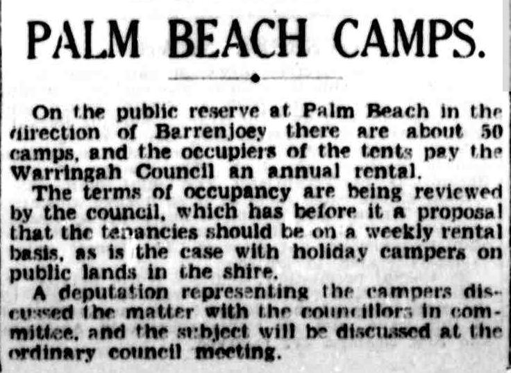
PALM BEACH CAMPS. (1940, February 29). The Sydney Morning Herald (NSW : 1842 - 1954), p. 10. Retrieved from http://nla.gov.au/nla.news-article17660518
CAMPERS AT PALM BEACH Must Now Pay Rent.
Campers on the public reserve at Palm Beach will in future have to pay an annual tent of from £6 to £9 according to the size of their allotment. Warringah Shire Council made this decision last night on the casting vote of the president Councillor Green. An alternative proposal before the meeting was that campers on the area should pay a weekly fee similar to charges made else-where in the shire Notice of a rescission motion was given for next council meeting.
At present 54 campers are on the Palm Beach area where there is room for about 150 sites. Nine new applications were received at the council meeting. CAMPERS AT PALM BEACH (1940, March 21). The Sydney Morning Herald (NSW : 1842 - 1954), p. 12. Retrieved from http://nla.gov.au/nla.news-article17664606
Early in 1947, in part in recognition of the bruised psyche of all who had survived this conflict, and with a firm basis in real truth in other cases, the popularity of ‘holiday camping’ was touted again and lends an insight into Avalon’s Camping grounds and tents fitted out like houses, complete, in some cases, with small plots of flowers:
Canvas Holiday . . . By SUSAN ROSS
HOLIDAY camping is reaching a new peak of popularity this summer. Reasons are the scarcity of accommodation at resorts, a more generous petrol allowance for motorists, and the disposal of military equipment which is ideal for campers. January, when schools are closed, is the month for family holidays. For the last week or more thousands of families, have moved into canvas and. caravan settlements at favourite spots throughout the State. Lately—to take just one popular area – there have been 900 tents at Lake Park, Narrabeen Lakes, 500 at Philip Park, Palm Beach, and 150 at Avalon Beach.
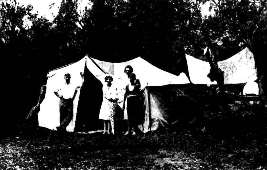
Few rigours remain attached to holiday camp life. Primus and oil stoves and a multitude of portable domestic gadgets, mostly from military disposal stores, have seen to that. WHEN I visited the camping ground at Avalon Beach recently, 150 tents and caravans housed a sun-tanned community, lacking few - of the comforts of home -Washing fluttered on tent - ropes, radios gave the news and there was a healthy sound of primuses and kerosene stoves working to prepare their mid-day meal.
I called at a smart green and white tent which Mrs. Elsie O'Day, of Arncliffe, her husband, and three small children, are sharing with Mr. and Mrs. H. Bowden, of Ashfield, for six weeks of the school holidays. They conducted me through the tent which was divided by curtains into three rooms. The bedrooms contained folding beds and collapsible wardrobes and cabinet. Hand mirrors were fastened to tent poles. In the living room they have a long folding table, seven folding chairs, an ex-army ice food box, and a folding food cabinet. "We have made full use of army equipment," Mrs. O'Day said. "The ice box was one that was used in the front line for keeping food hot for the troops, but makes a perfect ice chest."
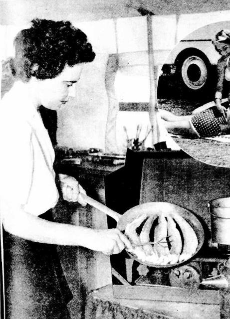
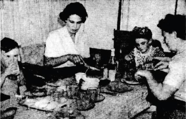
Above: IN a well-equipped canvas kitchen Mrs. H. Bowden, holiday camper at Avalon Beach, prepares a fish lunch. Below: Mrs. Bowden (centre) at lunch with Mrs. O'Day and her children in the canvas "dining room" of their- camp.
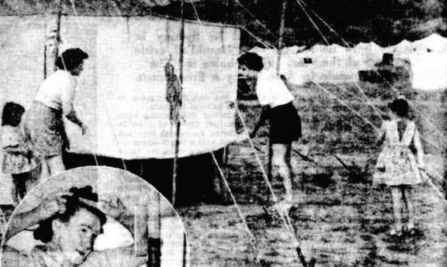
Frequent adjustments of tent ropes are necessary. The material stretches when dry, shrinks when damp, (insert) Nothing is more handy in a tent than a hand mirror(left) fastened to a pole.
A caravan painted cream and orange and stationed near the O'Day's tent caught my eye. I called over and found Mr. and Mrs. J. Southwick of Glenbrook at home. Canvas blinds, attractively striped in orange, brown, yellow, green and beige, keep the caravan cool inside and the curtains Mrs. Southwick made and gauze coverings keep out stray flies and insects. inside green and beige linoleum covers the floor, matching the green Chairs and table. At night the table is lifted out allowing the cushioned bunk behind it to collapse into a double bed. Another double bunk forms the opposite end of their 14ft 6in x 6ft 4in house. Canvas Holiday. (1947, January 7). The Sydney Morning Herald .p. 12 Supplement: The Sydney Morning Herald Magazine.. Retrieved August 4, 2012, from http://nla.gov.au/nla.news-article27903905
Post-war residents who settled in Avalon Beach shared stories of having to make their own bricks and build their own homes, or live in tents in the meantime. This article records:
"If you want a thing done, do it yourself," was a pioneer's precept.
By FRANK SNOW
Once more it is being put to practice by some house-less Sydney families. Tired of waiting for the contractor who never comes, they're. building their own homes : Within a 20-mile radius of Sydney's G.P.O., scores of families are living a home-life that puts the clock back 100 years. Like the early colonists, they are roughing it in all sorts of temporary structures while they build their own homes. Outdoor fireplaces, creek-bank burdening water carrying, kerosene lamps and candles, and general bunk raw conditions are being endured by some of the women belonging to a new age of pioneers. Most of the amateur home-builders are at outlying districts-Liverpool, Moorebank, Asquith, Mt Colah, Kuring-gai, Berowra, Newport, and along the coast to Avalon. In some cases whole neighbour-hoods appear to have been gripped by the ''build your own home" craze.
Most municipal councils and urban shires are anxious to help the owner of a building site who wants to build, and subject to certain conditions permits, are issued to erect "temporary" premises as an abode. Some people, because of difficulties in getting building materials, have already been a year or more in their temporary habitations. Councils extend the permits in such unavoidable circumstances. "IF you want a thing done, do it yourself," was a pioneer's precept. Once more it is being put to practice by some house-less Sydney families. Tired of waiting for the contractor who never comes, they're., Building their own homes. (1947, May 13). The Sydney Morning Herald, p. 11. Retrieved from http://nla.gov.au/nla.news-article18025875
Hotel Plan Opposed At Avalon
A number of Avalon residents yesterday opposed the transfer of a hotel licence from Redfern to Avalon. They claimed that the hotel would disturb the peace of the area, and would attract an undesirable class.
Charles Leslie Dawe applied to the Metropolitan Licensing Board for the conditional removal of the publican's licence of the Royal Standard Hotel, Cleveland Street, Redfern, to Barren-joey Road, Avalon.
"QUIET DISTRICT"
Among the objections raised by residents were:
Henry Robert Holmes, of Old Barrenjoey Road, Avalon (retired clergyman): The district was quiet and suitable for family life. Campers were of a most respectable type. He had not met one resident in the district in favour of a hotel.
Cecil Leslie Cook, of Avalon Parade, Avalon Beach (exporter): If a hotel was established at Avalon a less desirable type of camper would be attracted to the camping reserve. Road traffic would also become more congested..
DISORDER FEARED
Frederick Fuller: A hotel would lead to drunkenness and disorderliness.
Douglas Bernard Sheather: The district was sufficiently catered for already.
George K. Dunbar (sales manager and a Warringah Shire councillor): Population at Avalon did not warrant a hotel.
Gordon Henry Lobban (motor car salesman and an ex-Serviceman): The only new buildings at Avalon at pre-sent should be new homes.
The further hearing was adjourned till Friday.
Mr. W. Lieberman, of Messrs. Lieberman, and Tobias, appeared for the applicant; Mr. J. E. Cassidy, K.C, instructed by Messrs, Maund and Kelynark for objectors ; and Sergeant J. H. Milne for the police. Hotel Plan Opposed At Avalon (1947, June 4). The Sydney Morning Herald (NSW : 1842 - 1954), p. 5. Retrieved from http://nla.gov.au/nla.news-article18028939
However, with the increased clearing of trees that hold the hills in place around Avalon to build homes, along with heavy rain periods, those living in the campsite had no where to go when the place they lived flooded, as it had always done:
HOLIDAYERS FIGHT FLOOD
Dinner plates, jardinieres, mattocks and broken oars were among the implements used by surf-club members and campers in their fight to prevent a complete wash-out of the camping area at Avalon last night.
AT One time the water was 6in. deep in many of the camps, and channels had to be dug right through the tents to let the water escape.
Surf Club members realised shortly after 7 p.m. that heavy rain in the hills behind Avalon would sweep through the camping area, which is situated in a valley. Their task was made even more difficult when a water drainage pipe on the hillside broke and added to the streams of water that cascaded down into the valley. Children and aged people assisted in digging trenches around all of the 168 tents in the area, and also in filling and placing sandbags to prevent further flooding. They worked in pitch darkness and drenching rain.
Mr. A. Richmond, of Croydon, who has been camping at Avalon for 17 years, said this morning that the flooding was the worst he had ever seen there. Of the 168 tents, more than 120 had at least three inches of water in them when the flood was at its worst. Campers in the area paid a tribute to the work of the surf club members. HOLIDAYERS FIGHT FLOOD (1948, January 2). Daily Mirror (Sydney, NSW : 1941 - 1955), p. 1 (Noon Edition). Retrieved from http://nla.gov.au/nla.news-article273556983
Some long term residents recall flooding through the Avalon Camping Grounds as a regular occurrence and seeing tents and possessions being swept from the area "all the way to Careel Bay".
Another storm and flood came soon after:
THEY SUFFERED DISCOMFORT FROM THE RAIN: Mr. Syd Forrester, of Leichhardt, digging a trench during heavy rain in an effort to prevent the flooding of his tent at the Avalon camping ground yesterday.
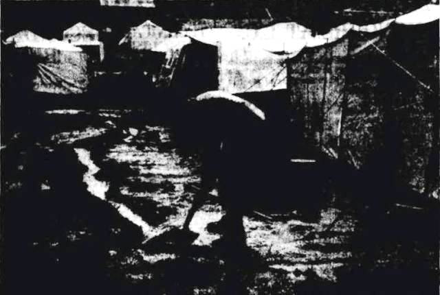
The occupants of six of the 90 tents on the reserve left for home. THEY SUFFERED DISCOMFORT FROM THE RAIN. (1948, January 15). The Sydney Morning Herald, p. 3. Retrieved from http://nla.gov.au/nla.news-article18057497
Published in the child's section of this newspaper, a visitor's perspective during Summer:
AVALON: Avalon Beach has a camping area, with golden sandhills forming a background. It's a lovely place to picnic. There are grassy slopes to eat your lunch on, and there are slippery-dips, swings, monkey-bars and many other delightful things. The surf is beautiful, but if you prefer still water, you can swim in the rock baths. Nearly every weekend I go down to our caravan and spend enjoyable days basking in the sunshine. If you like walking you can visit St. Michael's Cave. It has a small entrance but a large interior. — Bruce Arbon, 497 Great North Road, Abbotsford. RAMBLER'S NOTEBOOK (1948, December 26). The Sun (Sydney, NSW : 1910 - 1954), , p. 3 (SUPPLEMENT TO THE SUNDAY SUN AND GUARDIAN). Retrieved from http://nla.gov.au/nla.news-article228693060
Another Summer flood in 1951 records one of he garages one family was living collapsed:
Cloudburst Hits Avalon camp
FLOODWATER SWEEPS HOME AWAY
A cloudburst at Avalon last night carried away a garage home, wrecked tents, flooded cottages, and stalled cars.
An elderly man and a young boy waded waist-deep in swirling wafer to rescue a woman and three children trapped in the garage. Five families flooded
They carried the woman and her children to safety a few seconds before the garage collapsed. John Crawford, 14, and Mr. John Blaydon, rescued the family from the garage. They carried the woman and children to a neighbour’s house and ran back to the camping area to help other rescuers.
A woman who saw the garage swept away said a wall of water lifted it clear of its foundations. "As rescuers dragged the woman and kiddies clear, the walls folded up and the roof collapsed," she said. Water from a canal flooded families in five cottages on the lower side of Avalon Parade. As floodwaters poured into the cottages men carried, their wives and children to safety. Tents collapse Water two to three feet deep from the overflowing canal flooded the camping area. Two lifesavers, Ken and Neil Davidson, waded and swam to save families trapped in collapsed tents. They carried women and children to cars which neighbors had parked above the floodwaters in Avalon Parade. A few minutes after drivers had parked their cars a 3ft. wall of water poured from the canal and flooded the street. The water swamped the cars before the drivers could get away.
An Avalon resident, Mr. Geoff Robin, ran a shuttle service in his car carrying soaked campers to his home in Avalon Parade. Last night 20 homeless campers spent the night with Mr. Robin. They slept on lounges, stretchers, floors, and verandahs.
Mr. J. Hughes, caretaker at the camping area, said that 15 families, including two or three women with babies, were camping for the night in the Avalon surf sheds. He said that campers lost clothing, trunks, and suitcases, which the floodwaters had washed down the canal and out to sea.
Mr. Hughes added: 'There was no panic. Most of the people were laughing and joking as they moved about their tents tying things down."
Rescue team
Mr. W. J. McDonald, a newsagent, of Avalon Parade, helped to organise a team of rescue workers, Mr. McDonald said: "The storm burst about 8pm
"I've never seen anything like it. "You 'couldn't see your hand in front of your face." Cloudburst hits Avalon camp (1951, January 24). The Daily Telegraph (Sydney, NSW : 1931 - 1954), p. 5. Retrieved from http://nla.gov.au/nla.news-article248511918
However, the post-war shortage of materials began to tell on those trying to build a home and those who were forced into the camping areas in the meantime. The stories of living in a tent or living in a garage were common in our area - just two years prior to this the council had tried to kick people out of Palm Beach camping grounds, with the then Minister for Lands stepping in and pointing out people wee there due to shortages of materials and shortages of homes.
The Council then decided those living in garages, or building their own dwellings, needed their oversight as well - a reasonable expectation then as it nowadays and required, was still an imposition and a step too far for returned Defence Force service personnel when the council decided it would evict them form these homes as well. Warringah Shire Council sounds pretty heavy-handed, a bit bullying and too eager to send a 'get a lawyer' warning with its initial instructions to those it thought it was in charge of.
This report shares a few insights, but does not indicate how much more money residents were expected to hand over, although those who were living here then, and all attested to having to live in a shed or a garage initially due to lack of materials and money, certainly had to make every penny count:
Warringah Shire Campaign - Shack and Tent Dwellers Lose Their Permits - Check For Rackets
Temporary camps and huts at Palm Beach.
More than 1,000 families living in garages, tents, sheds and shacks between Manly Vale and Palm Beach are affected by a recent decision of Warringah Shire Council to clean up sub-standard homes. Last week the council started to send out hundreds of notices, informing occupants of "temporary dwellings" that permission to occupy the dwellings had been revoked by the council.
The council informed the people that they would have to comply with certain provisions to get a new order to remain in occupancy.
The president of the shire, Cr. J. L. Fisher, said the council had taken this action to:
- * Clean up a large number of sub-standard homes;
- * Stop racketeers from fleecing homeless people;
- * Improve health standards in the shire.
"We are not refusing a home to the genuine homeless, but we are making it impossible for the racketeer and the speculator to deal in temporary dwellings," he said.
Cr. Fisher said the racketeers had exploited homeless people by erecting a garage or temporary dwelling on a block of land, putting a few sticks of furniture in it, and selling it as a "home" for big money. There were about 1,100 temporary dwellings in the shire.
Three Conditions
The council in the past had waived building regulations to allow homeless people to occupy temporary dwellings while they built a house. Cr. Fisher said. In hundreds of instances the owners of such places had made no attempt to erect a house.
Now permits to occupy a temporary dwelling would be issued only provided:
- THE BUILDING is to be part of a permanent structure approved by council;
- THE APPLICANT makes a statutory declaration that the building would be used as a residential building;.
- A CAVEAT is entered on the deeds of the property showing it to be a temporary dwelling-not transferable by law.
Cr. Fisher said people in temporary dwellings who intended to build permanent homes on their land would be given reasonable time to do so.
PALM BEACH TENTS
Unless council officers were satisfied that these people were making attempts to erect permanent homes, action would be taken. He said the council at a later meeting would determine its attitude to people who were living permanently in canvas homes on council camping areas at Palm Beach, Lake Park, and other places.
PAYING IT OFF
These people paid a camp fee of 15/ a week to the council. Comments from occupants of temporary dwellings in the area last week included these:
Mr. Peter Minigle, Palm Beach camping area: "I am a pensioned stonemason, and could not afford to live any-where else. My wife and I are comfortable here, and much healthier than when we were living at Paddington."
Mrs. M. Potronljevic, Careel Head Road, North Avalon: "We don't like it, but we have to live in a garage until we can build a home. My husband and I had nowhere else to live when we married, and paid £1,000 for the land and dwelling. We are still paying it off before we can build."
A woman at North Avalon said she was paying £2 a week rent for a 24ft by 12ft dwelling erected by a man who had since built a home on another block for himself. A man at Mona Vale said he had built the first two rooms of his home, but was held up for finance to complete the dwelling.
Another Housing Problem - Injustice Seen To Landlords
The president of the N.S.W. Real Estate Institute, Mr. Harry Amadio, said proposed amendments to the Landlord and Tenant Act ignored the most important question for the home owner--when could he gain possession of his own home. Nor did they provide any relief to property owners whose charges were pegged at 1939 levels.
Major provisions of amendments, approved by the State Cabinet but yet to be passed by Parliament, are that Federal Land Tax may be taken into consideration in rents for some large properties, and that premises let for a continuous period of more than eight weeks to be disqualified as "holiday premises."
The amendments fail by far to remedy injustices and anomalies of the Act," Mr. Amadio said. The amendments do nothing to encourage an increase in urgently required accommodation, either by way of new buildings for letting purposes. or subdivision of large houses to provide home units.
"Owners will not construct new buildings nor will home owners subdivide their homes, knowing that they will be compelled to take rentals based on 1939 values and, to make matters worse, will have no control over their tenants."
Mr. Amadio said that if a person subdivided his home and accepted a tenant he could not be sure of getting the tenant out again, even if he turned out to be a black-marketeer, S.P. bookmaker, or habitual drunkard.
COSTLY COURTS
The owner would have to go through the long procedure of the Courts and he would be lucky if it cost him less than £50. Even then he would be quite unassured of success.
Mr. Amadio said rents were pegged on 1939 levels, but it was safe to assume that most owners of properties were receiving a smaller net return today than in 1939. Warringah Shire Campaign Shack And Tent Dwellers Lose Their Permits (1952, May 25). The Sunday Herald (Sydney, NSW : 1949 - 1953), , p. 5. Retrieved from http://nla.gov.au/nla.news-article28671967
On July 28th, 1952 four feet of water rushed through these tents again. Those living here then have told the news service those forced to live permanently in the Avalon Camping Ground were avoided by some garage or cottage dwelling residents, their children warned to stay away as they were ‘gypsies’.
Another flooding quickly restored the prevalent community spirit that was and is the village of Avalon’s prevailing tendency:
Freak Storm Hits Avalon: Drives Out Tent Dwellers
A freak hailstorm yesterday flooded many parts of Avalon, doing hundreds of pounds' worth of damage. Scores of people living in the camping area at Avalon were forced to leave their homes. Tents were torn to-shreds and the roofs of caravans severely damaged. Several tents and the furniture inside them were washed out to sea by floodwaters. Most of the families living in the camping area were given shelter for the night in the Avalon surf shed.
Mrs. Joyce Andries, of the Avalon Fire Station, said last night that immediately residents realised the floodwaters were rising, volunteers raced to the camping area to help to evacuate the children. The children were carried to safety through the racing water. Most of them were taken to the Avalon surf sheds, and the remainder were taken to the homes of relatives and friends.
Among the worst sufferers in the camping area were Mr. and Mrs. V. Harrington, who estimated their losses at about £.250. Their tent was not washed away, but damage to the roofing, sides and floor coverings was "enormous," said Mr. Harrington. The roof of Harrington’s tent was torn to shreds by the hailstones while water roared over the floor, destroying floor coverings and food supplies. Mr. Harrington had to use a suction pump to clear the water from the tent. He said he had only just cleaned up and repaired the damage done by last Saturday morning's floods. The storm began shortly after 2 p.m. and lasted for nearly three and a half hours.
Hailstones, measuring almost two and a half inches across, rained on the shopping and camping centres. Stormwater, in places three feet deep, raced through the shopping centre, flooding shops and homes.
Hundreds of pounds' worth of stock in the shops was destroyed. Road traffic from Palm Beach and Sydney was dislocated. Vehicles were unable to pass Avalon.
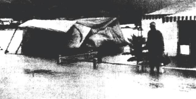
The tent on the left, owned by Mr D. Needham, was completely capsized by the rushing waters.
One of the shops which suffered most damage was Le Clercq's general merchandise store in Avalon Parade. Mr. Le Clercq, the owner, bored holes in the floorboards in an attempt to drain away the two feet of water which was damaging his goods.
He said he had only just cleaned up the debris from a flood which occurred on Friday. He had suffered more than £250 worth of damage in that flood.
The rush of water through Avalon Parade was so great at one stage that several cars were almost submerged. The swirling flood carried one car almost 200 yards before dumping it on the pavement.
At Newport 235 points fell. In most places the rain fell in less than an hour after 4p.m.
A waterspout estimated to be 300ft in height, was seen yesterday afternoon moving over the ocean off Long Reef golf links, between Collaroy and Deewhy. It was three or four miles out to sea.
Constable J. Hannon, of Collaroy, said he first saw the waterspout at 4 p.m., and watched it for 20 minutes.
Cars were pulled up for 200 yards along Pittwater Road while the occupants watched the waterspout.
"It disappeared into a heavy cloud about 400ft up, and seemed to be moving north," said Constable Hannon.
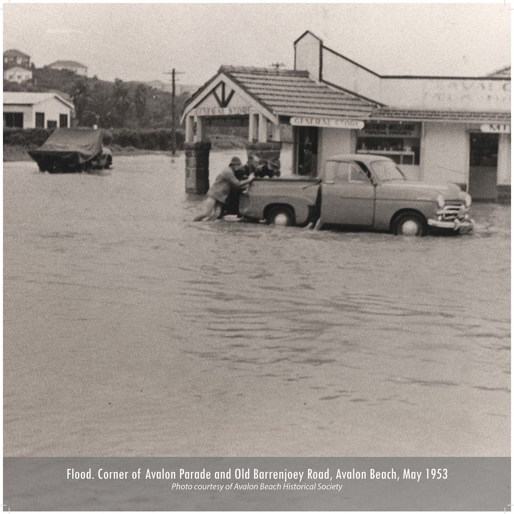
[A Weather Bureau spokes-man said last night that "waterspout" was the name given to a funnel-shaped tornado at sea. It was caused by intense cyclonic wind circulation in a confined area. A resultant low pressure area in the vortex of the tornado forced the air upwards, sucking up huge amounts of water and fine spray sometimes 400ft into the air. Freak Storm Hits Avalon: Drives Out Tent Dwellers. (1953, May 7). The Sydney Morning Herald, p. 1. Retrieved from http://nla.gov.au/nla.news-article18372783
More reports of these May 6th and 7th 1953 floods:
STORMS HIT COAST AREAS
Flood Toll Rises
Fierce storms which have lashed the east coast of N.S.W. for the past 24 hours are expected to reach gale force tonight. The storms have battered the coast from Newcastle to Bega. More than 2in. of rain was Recorded at Sydney Weather Bureau- between 9 a.m. and 3 pm today. Nearly an inch fell in the city between noon and 3 p.m. Since 9 p.m. yesterday, the bureau has recorded 3in. of- rain.
Some suburbs have had more than - 5in. between 9 p.m. . yesterday and 3 . p.m. today. Heavy rain and flooding have: — 0 Forced 30 families at Avalon Beach to evacuate their tent and caravan homes. . , , -0 Compelled 200 persons at Prince Edward Park, on the Woronora River, to prepare to evacuate their homes this afternoon as floodwaters lapped the floorboards. .
HOMES_FLOODED AT AVALON
Disrupted city and country rail services. Cut main highways and Sydney roads. Blacked-out many Sydney suburbs. Filled near-Sydney dams to overflowing. Damaged suburban homes and shops. Put 3700 suburban telephones out of service, and disrupted some trunk lines. Trapped hundreds of cars on flooded suburban roads. Closed Mascot airport early this afternoon.
Floodwaters 3ft. deep forced the 30 families at Avalon Beach to evacuate their tent and caravan homes. This is the second time in 24 hours Avalon campers have been flooded out. Swirling tidal waters demolished two of the homes, carrying one of them 50 yards down a flooded drainage ditch. About 20 tent homes are in water more than 2ft. deep, and all the furniture has been saturated. Campers fear the high tide later today may carry away more of the homes unless the rain stops.
Soup, sandwiches
Twenty children are being cared for at the home of the camp caretaker, Mr Charlie Hughes. Mr. and Mrs. William Gillette, whose home is under water, are looking after the children. Many residents have been living mainly on soup and sandwiches since the deluge began 48. hours ago. A general store and a real estate agency at Avalon are conducting business today with water over the floorboards. STORMS HIT COAST AREAS (1953, May 7). Daily Mirror (Sydney, NSW : 1941 - 1955), p. 1 (Late Final Extra 6). Retrieved from http://nla.gov.au/nla.news-article277355551
STORM HAVOC ALONG COAST
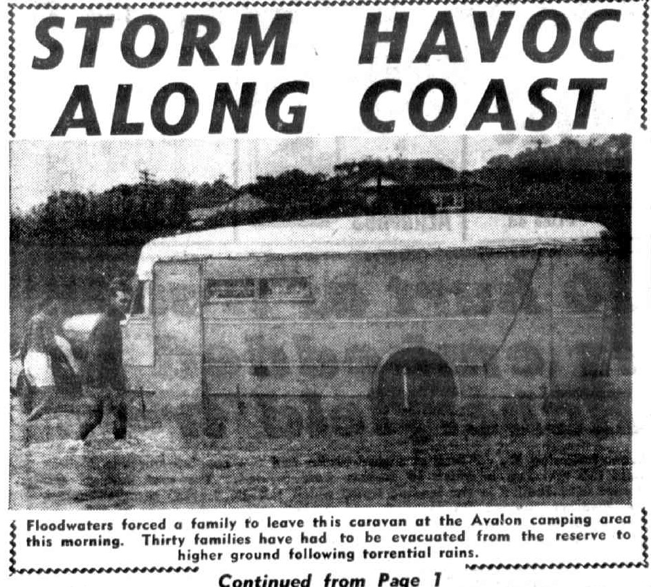
Floodwaters forced a family to leave this caravan at the Avalon camping area this morning. Thirty families have had to be evacuated from the reserve to higher ground following torrential rains. STORMS HIT COAST AREAS (1953, May 7). Daily Mirror (Sydney, NSW : 1941 - 1955), p. 2 (Late Final Extra 5). Retrieved from http://nla.gov.au/nla.news-article277356518
Man Rescues Three Stranded In Flood
A man waded through a surging flood at Narrabeen yester-day to rescue an elderly woman and her two grandchildren trapped on a bridge. The rescuer, John Max-worthy, 34, of Alfred Road, Deewhy, made three separate journeys through the flood.
Rescued were: Mrs. Nena Hansen, 69, of Grover Avenue, Deewhy West; Joan Addicoat, 22, and her brother, Noel, 13, of O'Sullivan Road, Bellevue Hill. Miss Addicoat and Noel, with their mother, Mrs. Dulcie Addicoat, were driving from Bellevue Hill to pick up Mrs. Hansen.
WATER RISES
When they reached a bridge across a creek in Carcoola Avenue, Deewhy, they found it under nearly two feet of water. Miss Addicoat and Noel went across the bridge on foot while Mrs. Addicoat remained in the car beside the creek. They returned about 10 minutes later with Mrs. Hansen to find that the water had risen to nearly four feet above the bridge.
They started to wade along the bridge, but half-way across they were swept off their feet by the swift-moving current. Miss Addicoat and her brother were able to grasp a rail of the bridge. They supported their grandmother for about a quarter of an hour.
Mrs. Hansen, unable to grasp the rail any longer, lost her grip, and was washed further along the bridge towards deeper water. Miss Addicoat waded after her grandmother and seized her by an arm just in time to save her from drifting into the lagoon.
Mrs. Addicoat drove for assistance and returned with several men. Maxworthy tied a hosepipe round his waist and plunged into the floodwaters. He first seized Mrs. Hansen and dragged her from the water. He then made two more trips to bring back Miss Addicoat and Noel.
The three rescued were taken to the home nearby of Mr. and Mrs. A. Davies, who gave them warm clothes and hot drinks. Later, Manly District Ambulance officers examined Mrs. Hansen and her grand-children. They were allowed to go home.
An exploding fireball yesterday smashed 10 windows and ripped the hair net off a woman in a house at Wahroonga. The fireball crashed into a tree 50 feet from the home of Mr. and Mrs. G. Tosi, in Junction Road. The blast, streaked with flame, hit the wall of the house, smashed windows, shattered all electric light globes in the house, and knocked out the fuse box.
Mrs. Tosi said: "There was a tremendous roar. I saw the terrible flash of the explosion as it came through the bed-room window. Glass shattered all round me.
"I was standing at the end of the bed when the blast tore off my hair net."
OTHER FIREBALLS
Two other fireballs caused damage in Sydney yesterday. One struck a home in Seaview Avenue, Newport, ripped off the roof, and flung it several feet into the garden.
The house was empty at the time.
Another fireball struck a printing press in Parkes Road, Deewhy.
People were forced yesterday to move their tents at Avalon camping area for the second time in two days. Several families are living in the Avalon and Narrabeen surf sheds.
Pittwater Road, between Collaroy and Avalon, was blocked in several places last night by floods to a depth of two feet.
Homes along Pittwater Road, South Collaroy, near Long Reef Point, were damaged yesterday morning when struck by gale-force wind.
Tiles were ripped off roofs, windows burst, and fences blown down. Man Rescues Three Stranded In Flood (1953, May 8). The Sydney Morning Herald (NSW : 1842 - 1954), p. 1. Retrieved from http://nla.gov.au/nla.news-article18369930
See: Narrabeen Lagoon And Collaroy Beachfront: Storms And Flood Tides Of The Past
The high cost of living in a tent is brought into focus again a few days later -as is the resolve to close the Avalon Beach one:
Tents a nice perk — AT £30.000 A YEAR
By Larry Boys
THE night the storm hit Avalon was the sort of night Noah picked to launch his Ark.
As Avalon's tent-dwellers cowered under their flimsy roofs, a great flood roared down the storm water channel. It ripped through makeshift bedrooms and alfresco kitchens, tore up floorboards, carried homes, people, dogs, tables, beds, and mutton chops away, in the flood. Several persons escaped death by hard swimming and good fortune.
Outsize hailstones pelted through membranous ceilings, and vicious winds turned canvas walls into flying kites. Mothers waded waist deep through floods, rescuing babies and family albums; whole tent-homes sailed away on the storm-water. It was nothing new.
Whenever there's a decent sort of a storm there's added misery at the "permanent" camps at Narrabeen, Avalon, and Palm Beach.
THE bitter thing about it is that these tent villages are, for the most part, the permanent homes of the people who live there. That these brown-paper-and- canvas settlements exist in our loveliest coastal resorts is a mocking commentary on the regulation-ridden State.; After 160 years of settlement, we find civilised, compulsorily educated Australians living in sub-standard conditions. But these areas, of Narrabeen, Avalon, and Palm Beach seem not to touch the official conscience. The State Government gives them the Nelson eye, and the Warringah Shire Council openly connives at their existence. "Connives" is just about the right word there. Hail, rain, or shine. Warringah Shire Council collects 15/ a week from the tenant of each tent, shack, or humpy.
On its three main camping areas, while city landlords are struggling to maintain and service houses and flats at pre-inflation fixed rentals, the Warringah Council coolly and effortlessly collects about £30,000 a year for letting homeless people camp on public reserves. These camps actually belong to you and me. According to the Minister for Lands (Mr. Hawkins), the Warringah Council, as trustee of these public reserves, has no right to permit any kind of permanent structure to be erected on them. Mr. Hawkins told the Council as much last year, when they tried to raise the Palm Beach camping fees' from 15/ to £1 a week.
The Council quietly dropped the idea, and hung on to the 15 bob. In return for this comfortable revenue, the Warringah Shire Council has provided open-air cold showers at Narrabeen and Palm Beach (the Avalon campers have to beg showers from the surf club) and a few lavatory pans. There's been no effort to give the campers anti-flood foundations or drainage, or to assist them repair their pitiful "homes" in the wake of the storm.
On the nights of the big storm, when dozens of tent-dwellers were wet, hungry, and homeless, it was the police, the social welfare workers, surf club boys, and private local citizens who did the right thing. They rushed into the flood and rain, salvaged and rescued, comforted and first-aided. But Warringah Shire Council— £30,000 a year landlords of these pitiful slums— did nothing to help.
The tent-dwellers didn't expect them to help. They know that it isn't only the storms that rip off your canvas room. The Council does, if the rent isn't paid regularly. Narrabeen campers say that on several occasions the "Council men" have snatched away tent, furniture, floorboards, and bedding from a family in arrears. In parts, these tent slums are as squalid as anything that leers between the lines of Tobacco Road of No Mean City
TAKE a look at the Narrabeen camp, for a start. It sprawls along the northern shore of the Narrabeen lagoon, on the starboard beam of the main Palm Beach Road. Enter from the eastern end, and you're among the "nicer" tents, the ones on the high ground where the flood doesn't linger much as it sidles through the floorboards. Here you have the Dutch" people, striving with paint, scrubbing-brush and elbow grease to preserve their ancient reputation for cleanliness. Some of them. like Mrs. Evert Harder, in Fifth Avenue (yes, that's what they call her tent "street'', are living in tents in a deliberate effort to save enough to buy their own homes. Move along towards the western end of the camp, between Third and First Avenues, and the smell hits you first. It's an all-embracing reek speaking of greasy cooking on kerosene stoves, wet bedding, drying out in the sun, damp floorboards rotting almost audibly, cabbage water and stale suds.
Everything is bedraggled — the tents, the women, the children, the cats, the pitiful flowers pining in the sterile sand. In a 12-by-12 tent-; humpy on Third Avenue lives Mrs. D. Hudson and her eight children; youngest five months, eldest 12 years. Her husband doesn't live there any more. The storm-rent walls of her tent gape open and her ceiling has a good view of the stars. In a partitioned corner, a huddle of double-bunks gives everybody a bed or part thereof, and the "living room" has a bare table, a chair, a kerosene cooker, and a heap of pots and pans. The family gets by on child endowment and a 30/ weekly grocery order from Social Services. .
"Twouldn't keep a cocky in corn," Mrs. Hudson says, "but we battle on.
"The .storms come and the walls go, and there's nothing to patch the holes with except faith, and that doesn't grow too well around here. Too exposed.
"The Council's always on on your back for the rent, and the Child Welfare about the kids.
"And if you want to use the copper in the laundry you have to have a stand-up fist fight with some woman who reckons she got there first. "Everything is damp and rotten, and the rats reckon they own the place. "But it's our only home.'
As you come over the hill into Avalon, there's a great notice that reads;
"SOS. TREES ARE THIS DISTRICT'S BEAUTY. SAVE THEM IF YOU CAN.?'
Impressed by this evidence of civic pride, you slide down the hill and into the Avalon camping area. The storm has festooned the camp's everyday ugliness with the pride of utter desolation. Mud. Mud. slime, filth everywhere Some tents and shanties hopeless, abandoned wrecks; others shattered but standing; others faltering at the end of a guy-rope.
You meet young, pretty Mrs. Fay Reynolds, whose husband, John, paid £250 (all their savings) for the hail-riddled shack they now call home. But it's the first home they've had since they married four years ago, and it's better, they reason. than going from pub to pub at £7 a week, just for a roof. They have a son, aged two.
"The day I was due to go into hospital with him," Mrs. Reynolds said, "the Housing Commission people laughed at us and said there were thousands worse off.
"If I hadn't 'gone,- into hospital that night I'd have had nowhere to sleep."
WARRINGAH Shire President, Councillor J L. Fisher says: "It costs my council about £50,000 a year to operate our Parks and Reserves Department.
"As our Beauty spots, and beaches are mainly enjoyed by visitors from other municipalities, it would be unfair to expect the Warringah ratepayers to bear the cost of maintaining them.
"So we raise most of the money by charging fees for camping, parking, and using dressing-sheds.
"We intend soon to close the Avalon camping area. Tenants who so desire will be given sites at Narrabeen
"We are considering plans to improve amenities at the camps by providing hot showers and washrooms, better laundry-facilities, and even a plug-in electricity supply"
So, it seems, the camps (or two out of three) will remain indefinitely as an anachronism to rigid regulations and specifications which drive near-crazy architects planning REAL homes for the people. Tent towns a nice "perk" (1953, May 17). The Daily Telegraph (Sydney, NSW : 1931 - 1954), p. 52. Retrieved from http://nla.gov.au/nla.news-article248693455
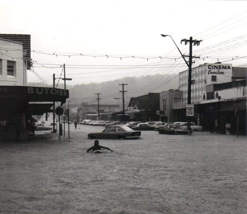
The storms over May 6 and 7, along with the Warringah Shire Council vision of how the area should 'look' building-wise, meant the camping grounds were finally closed due the perils of allowing people to live beside a creek on a floodplain.
The Warringah Shire Council Minutes records in the Meeting held February 16 1953 also show the complaints from residents who ascribed thefts in the area to those living in the campsite :
Avalon Beach and District Progress Association, 23/1/1953, Re: Avalon Camping Area - Referring to previous correspondence dating back many years wherein the Association has requested the removal of the Avalon Camping Area stating that the following robberies breaking and entering occurred around the fringe of such area during the recent: Christmas-New Year holidays: Le Clerc’s Store - £30 reported stolen. Walroys' Beach Kiosk - £5 goods stolen. Grantleys, Bellevue Avenue - £17 goods stolen., Franklands Barrenjoey Road - Telephone money stolen. The Chalet, George Street - Thieves disturbed. Gonsalves Kiosk - £25 stolen. McDonald's Store -Thieves disturbed.
Adding that the ratepayers of Avalon are incensed that this blot on the community should be allowed to exist, despite the Association's repeated representations to have this public reserve closed to campers. Further stating that drinking parties on the area are frequent, sanitary-arrangements are a menace to public health, and unless the camp is closed or removed this year-‘’they’’ will be-unable to support the present Councillors in the future.
Moved by Cr. Beach, seconded: Cr. Quinlan; that this letter be received and no action ordered thereon.
An amendment was moved by Cr..Mckay seconded by Cr. Berry; that the Avalon Camping Area be abolished from the cessation of "this season’’, or the 30 June, next, whichever first occurs and that camping sites be provided at Hitchcock Park with necessary facilities. Such sites to be occupied by campers for a Period not exceeding one(1).month. 48: The amendment was LOST then the motion-was then put and carried.
However, the move to close the camp wasn't going away. A few weeks later:
Avalon Camp To Be Closed;
The Warringah Shire Council decided on Monday night to close the Avalon camping area in three months' time. The shire president, Councillor J. L. Fisher, said the council considered the camp an eyesore and not in the best interests of the district. Forty-three families are living at the camp. Hundreds of people camp on the area during holidays. Councillor Fisher said accommodation would be found for Avalon campers who wished to transfer their camps to other camping areas in the shire. Avalon Camp To Be Closed. (1953, May 27). The Sydney Morning Herald, p. 3. Retrieved from http://nla.gov.au/nla.news-article18372351
Those living her responded with:
Campers Will Fight To Stay
Permanent residents of the camping area at Avalon will hold a meeting to protest against the decision of the Warringah Shire Council that they must leave in three months' time.
The council sent out notices last week to all owners of permanent camps on the reserve. Campers can move to sites at Palm Beach or Narrabeen, where they will pay the same fee of 15/ a week for a space 30ft by 30ft.
The council last year abolished another camp site at North Curl Curl.
Council employees said last week that the decision to keep permanent campers out of Avalon was an old one but that it had been hastened by the effects of the floods last year.
The site will be reserved for genuine holiday campers for periods of two or three weeks about Christmas they said.
UNFAIR EXCUSE
Mrs. W. Henry, who has lived in a camp at Avalon for 5 years, said yesterday that residents will fight to retain their tent properties.
"We have spent about £300 on this place since we came here, and we will lose nearly all of it if we have to shift to Narrabeen," she said.
Mr. Henry Harper, retired railwayman, said it was unfair that the council should use the excuse of a flood to shift campers to another site where floods were even more prevalent.
"The floods only affect an acre in the middle of the camp site. There is plenty of room for the tents to be shifted to higher ground," he said.
Mrs. T. Spreiikler, a Dutch-woman who recently arrived in the settlement, said her family and another Dutch family would lose considerably if they had to shift.
"We will fight," she said.
A PETITION
Some campers say they do not blame the council for the decision.
"A petition was circulated in Avalon to get rid of us. A lot of pressure has been brought to bear on the council, which has always been very fair in its dealings," said one.
And Narrabeen campers are not enthusiastic about welcoming more people to the crowded grounds.
Mrs. E. Mitchell said there are 93 families and only four coppers in the laundry. "They are going night and day now, seven days a week. What we will do with more families Heaven only knows." Campers Will Fight To Stay (1953, May 31). The Sunday Herald (Sydney, NSW : 1949 - 1953), p. 4. Retrieved from http://nla.gov.au/nla.news-article18512373
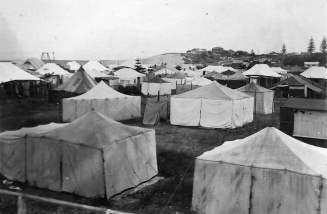
Left: Avalon Camp 1938, courtesy ACT State Archives on Flickr. Site hire is 10/- per week. For this water, sewerage, cleaning and supervision is provided. Warringah Camp its revenue is £11,000 p.a. Photographer unknown. Part of the Archives ACT collection.650 sites each 30' x 30'. this camp gives a slum impression; Policing is necessary and evictions. There are 11,000 sites in Warringah, the deficiency is 50%. Right: is stated to be the camp that once existed at Curl Curl.
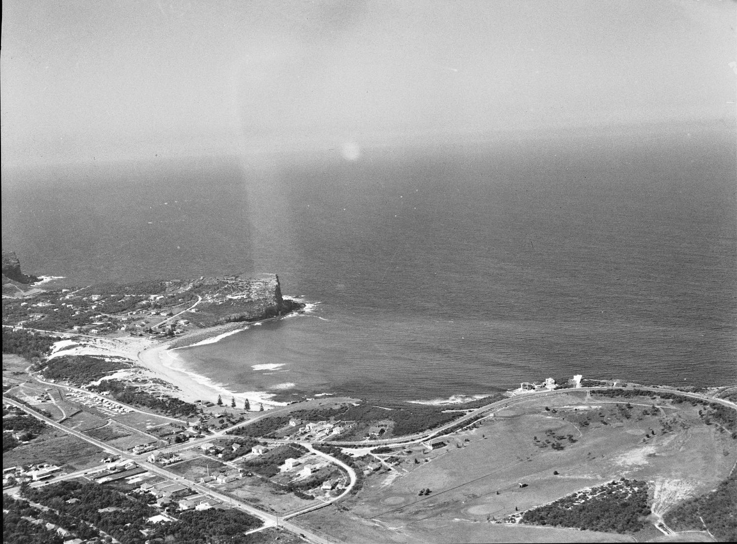
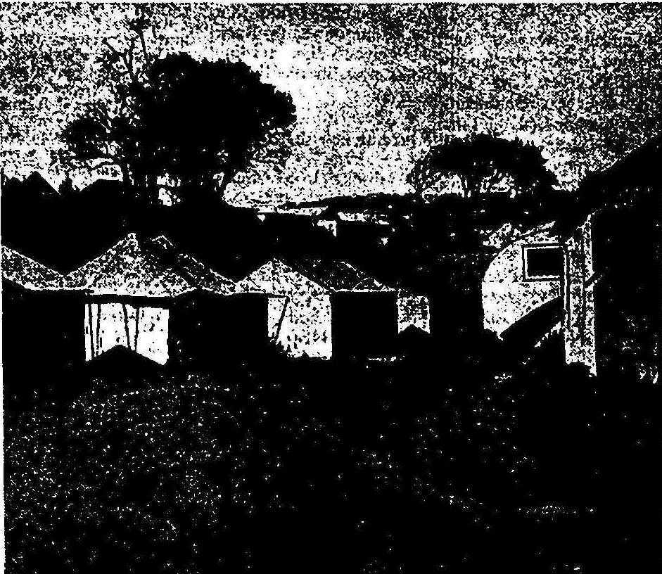
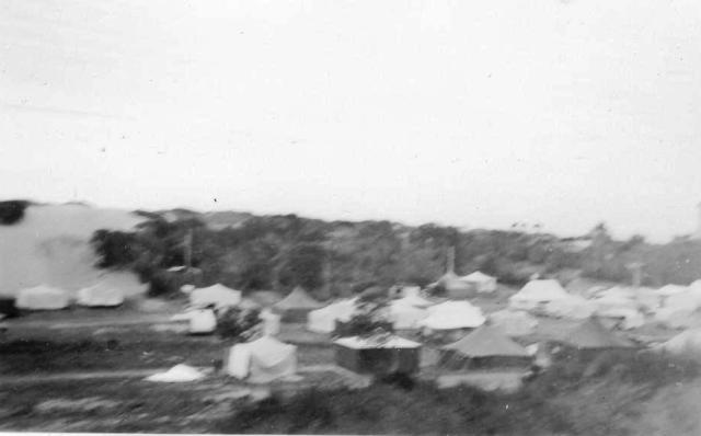
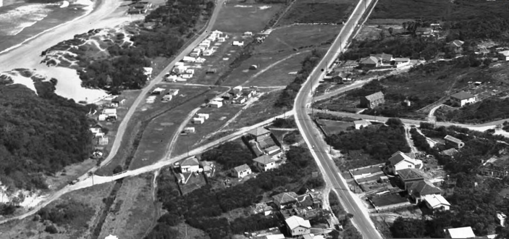
Avalon Beach & surroundings by Frank Hurley, 1950's, nla.pic-an23817014 (showing Avalon Camping Ground Tents). Courtesy National Library of Australia. Below - section from enlarged
Notes - Extras
Careel Creek Bridge-Cement Channel-way going in, and roadway being changed heading north to Palm Beach:
TRANSPORT (DIVISION OF FUNCTIONS) ACT, 1932.
MAIN ROADS ACT, 1924-1936.
PROCLAMATION.
(L.S.)
WAKEHURST, :Governor.
I, the Eight Honourable John de Vere, Baron Wakehurst, Governor of the State of New South Wales, in the Commonwealth of Australia, with the advice of the Executive Council, and by virtue of the provisions of the Transport (Division of Functions) Act, 1932, and in pursuance of the provisions of the Main Roads Act, 1924-1936, do by this my Proclamation declare that so much of the land hereunder described as is Crown land is hereby appropriated, and so much thereof as is private property is hereby resumed under the provisions of the Public Works Act, 1912, for the purposes of the Main Roads Act, 1924-1936, and that the land hereunder described is hereby vested in the Commissioner for Main Roads, and I hereby further, declare the land hereunder described to be a public road, and, in accordance with a recommendation of the Commissioner for Main Roads, the said land is hereby placed under the control of the Council of the Shire of Warringah.
Signed and sealed at Sydney, this twenty-sixth day of May, 1937.
By His Excellency's Command,
B. S. STEVENS.
GOD SAVE THE KING!
Description of the Land referred to.
All that piece or parcel of land situate in the Shire of Warringah, parish of Narrabeen, county of Cumberland and State of New South Wales, being part of lots 11 to 16 inclusive, deposited plan 14,883: Commencing at a point on a north-western side of Barrenjoey-road being the southernmost corner of lot 11, deposited plan 14,883 aforesaid; and bounded thence on the south-west by part of the south-western boundary of that lot bearing 318 degrees 50 minutes 14 feet 9£ inches: thence on the north-west by a marked line bearing 29 degrees 43 minutes 397 feet 9 1/2 inches to the high-water mark of Careel Creek; thence on the east by part of the highwater mark of that creek generally south-easterly to the north-western side of Barrenjoey-road aforesaid; thence on the south-east by part of that side of that road being lines bearing 235 degrees 35 minutes 261 feet 5 1/2 inches and 209 degrees 43 minutes 22 feet, to the point of commencement,—having an area of 2 roods 21 1-10th perches or thereabouts, and paid to be in the possession of A. J. Trunt, (Mrs.) E, Walshaw, H. C. Price, (Miss) N. Fillars, L. West and A. Walshaw.
Also, all that piece or parcel of land situate in the Shire of Warringah, parish of Narrabeen, county of Cumberland and State of New South Wales, being part of the land in Certificate of Title, register volume 3,847, folio 56 and part of the 100-ft. reservation adjoining: Commencing at a point on the high-water mark of Careel Creek bearing and distant 29 degrees 43 minutes 30 feet 9| inches from the northernmost corner of the firstly described parcel of land; and bounded thence on the north-west, west and south-west by marked lines bearing consecutively 29 degrees 43 minutes 33 feet, 26 degrees 34 minutes 40 seconds 71 feet 6} inches, 20 degrees 18 minutes 71 feet 6 1/2 inches, 14 degrees 1 minute 10 seconds 71 feet 6£ inches, 7 degrees 44 minutes 30 seconds 71 feet 6 J inches, 1 degree 27 minutes 50 seconds 71 feet 6j inches, 355 degrees 11 minutes 71 -feet 6£ inches, 348 degrees 54 minutes 20 seconds 71 feet 6£ inches, 342 degrees 37 minutes 40 seconds 71 feet 6 1/2 inches and 339 degrees 29 minutes 20 seconds 612 feet 7i inches to the south-eastern -side of a road 66 feet wide; thence again on the north-west by part of that side of that road bearing 62 degrees 40 minutes 14 feet li inches to a south-western side of Barrenjoey-road; thence on the north-east and east by parts of southwestern and western sides of that road bearing 159 degrees 29 minutes 20 seconds 724 feet and 174 degrees 58 minutes 40 seconds 409 feet 6| inches; thence on the south-east by marked lines bearing 282 degrees 20 minutes 50 seconds 11 feet Hi inches and 209 degrees 43 minutes 227 feet 6£ inches to the high-water mark of Careel Creek aforesaid; thence again on the south-west by the high-water mark of that creek generally north-westerly, to the point of commencement,—having an urea of 3 roods 29 9-10th perches or thereabouts, and said to he in the possession of the Council of the Shire of Warringah.
Also, all that piece or parcel of land situate in the Shire of Warringah, parish of Narrabeen, county of Cumberland and State of New South Wales, being part of the land in Certificate of Title, register volume 3,847, folio 56: Commencing at the intersection of a southwestern side of Barrenjoey-road with the north-western side of a road 66 feet wide bearing 339 degrees 29 minutes 20 seconds and distant 66 feet 5| inches from the northernmost corner of the secondly described parcel of land; and bounded thence on the south-east by part of the north-western side of the road 66 feet wide aforesaid bearing 242 degrees 40 minutes 14 feet li inches; thence on the south-west by marked lines bearing consecutively 339 degrees 29 minutes 20 seconds 596 feet 11 1/2 inches, 337 degrees 11 minutes 20 seconds 76 feet 5f inches, 332 degrees 35 minutes 30 seconds 76 feet 5£ inches, 327 degrees 59 minutes 40 seconds 76 feet 5f inches, 323 degrees 23 minutes 50 seconds 76 feet 5 1/2 inches, 318 degrees 48 minutes 76 feet 5| inches and 316 degrees 30 minutes 422 feet 2f inches to the south-eastern side of a road 66 feet wide; thence on the north-west by part of that side of that road bearing 62 degrees 40 minutes 14 feet 7 inches to the southwestern side of Barrenjoey-road aforesaid; thence on the north-east by parts of south-western sides of that road bearing 136 degrees 30 minutes 634 feet 9f inches and 3.19 degrees 29 minutes 20 seconds 791 feet 10£ inches, to the point of commencement,—having an area of 2 roods 2 3-10th perches or thereabouts, and said to be in the possession of the Council of the Shire of Warringah.
And also, all that piece or parcel of land situate in the Shire of Warringah, parish of Narrabeen, county of Cumberland and State of New South Wales, being part of a road 66 feet wide: Commencing at a point on a south-western side of Barrenjoey-road being the easternmost corner of the thirdly described parcel of land; and bounded thence on the north-east by part of that side of that road bearing 159 degrees 29 minutes 20 seconds 66 feet 5| inches; thence on the south-east by part of the south-eastern side of the road 66 feet wide aforesaid bearing 242 degrees 40 minutes 14 feet li inches; thence on the south-west by a marked line bearing 339 degrees 29 minutes 20 seconds 66 feet 5| inches; thence on the north-west by part of the north-western side of the road 66 feet wide aforesaid bearing 62 degrees 40 minutes 14 feet li inches, to the point of commencement,—having an area of 3 4-10th perches or thereabouts. (D.M.K. No. 479-1,171) (3634) TRANSPORT (DIVISION OF FUNCTIONS) ACT, 1932. (1937, June 4). Government Gazette of the State of New South Wales (Sydney, NSW : 1901 - 2001), p. 2129. Retrieved from http://nla.gov.au/nla.news-article224751674
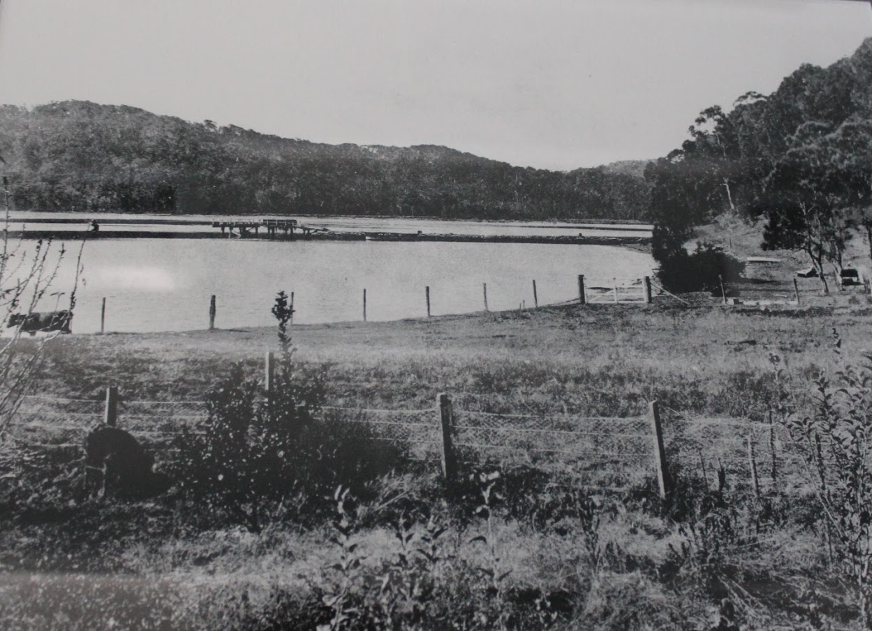
Volume 3,847, folio 56 is the land donated by James Young and Robert Browning (Palm Beach Land Co - follow on from Barrenjoey Land Co.) to the then council and used as a tip, filling in what had been wetlands and a mangrove area, and later used for a tennis courts area, Hitchcock Park and the Careel Bay Soccer (Playing) fields - as well as being where the Careel Creek road bridge and concrete drainage pipe was placed with works completed on March 10 1938 - this concrete drainway/roadbridge is still in place:
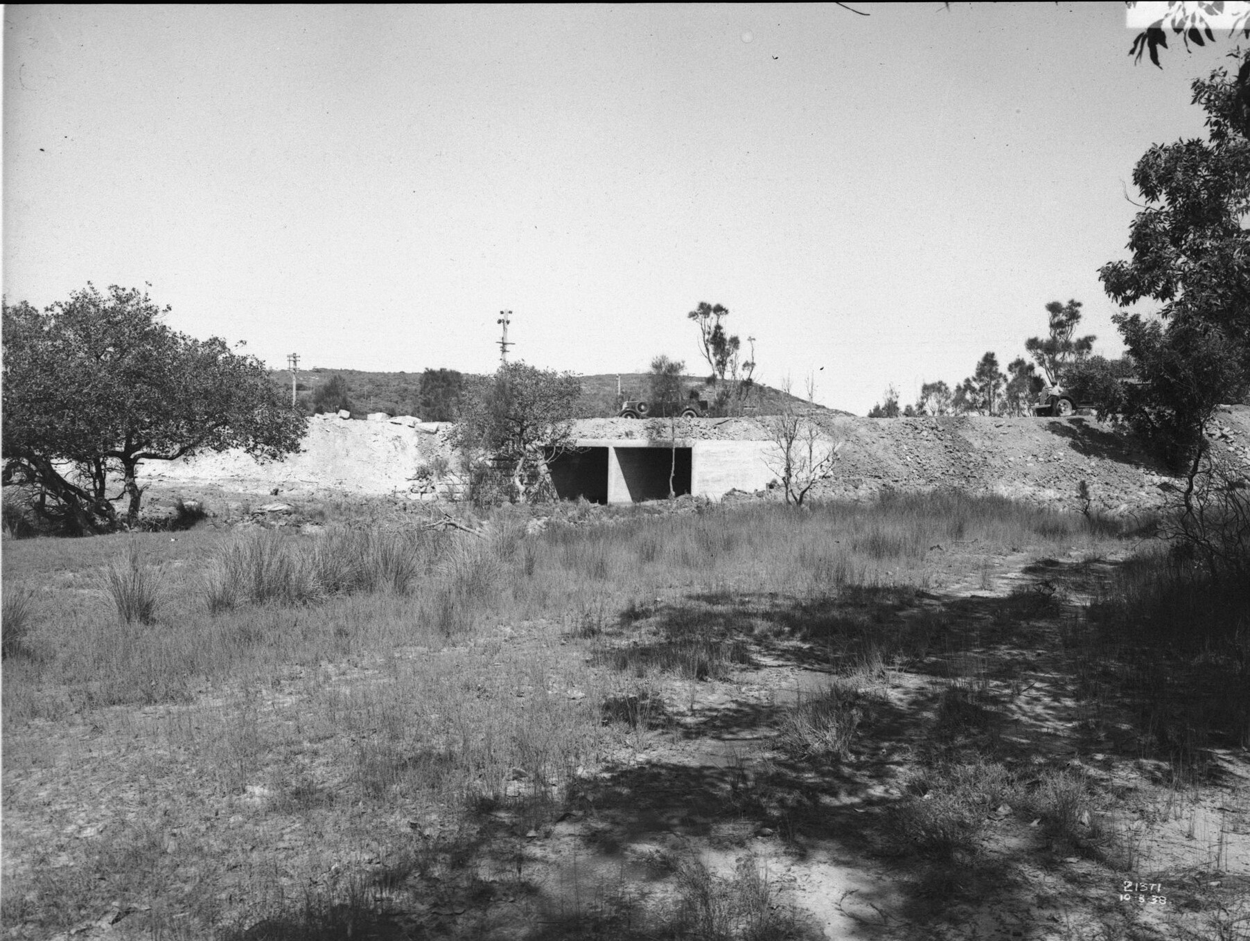
'Careel Creek looking south' 10.3.1938 - and road being built/widened. Item: FL3663714, courtesy NSW Records and Archives
.JPG?timestamp=1747796175726)
.JPG?timestamp=1747796233663)
Same concrete drain/roadway bridge - May 2025 - looking south-east from track leading to tennis courts
.jpg?timestamp=1747794855081)
.jpg?timestamp=1747794893300)
.jpg?timestamp=1747795053160)
.jpg?timestamp=1747795122664)
.jpg?timestamp=1747795167692)
James Young was one of the original Directors of the Barranjoey Land Company, a relative of Mr. Wolstenholme, who was in turn a son of Maybanke Anderson. He was a barrister by profession, served as President of Ku-ring-gai Council at one time.
The Minutes of the Warringah Shire Council Meeting of 27th October,1924 state ''The President verbally reported having interviewed Mr. James Young and submitted a letter from Mr. Young, offering to sell his 10 ¾ acres at Careel Bay fronting Barrenjoey Road for £700 on terms, namely, £50 deposit, and the balance in annual instalments of £100 each with interest at 6 ½ % on unpaid purchase money. It was resolved, - (Crs. Hewitt, Hitchcock) That the offer be accepted and the terms approved, but that the President endeavour to arrange for a smaller deposit. ''
See: Careel Bay Playing Fields Reserve - Including Hitchcock Park: Birds, Boots & Beauty (History page)
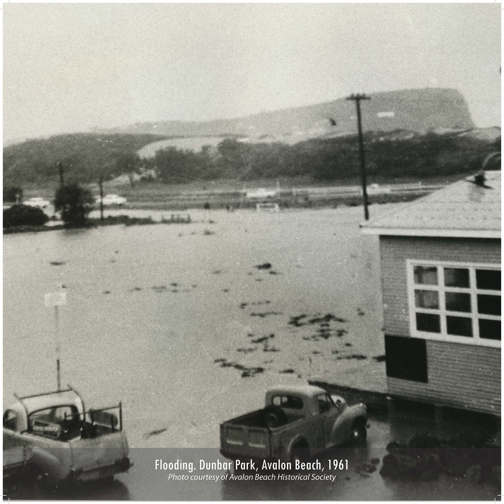
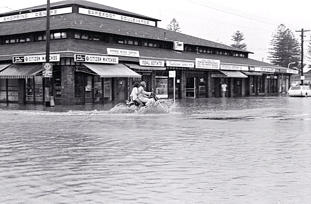
These photos, taken in May 1974 by John Stone, shows Old Barrenjoey Rd in flood.
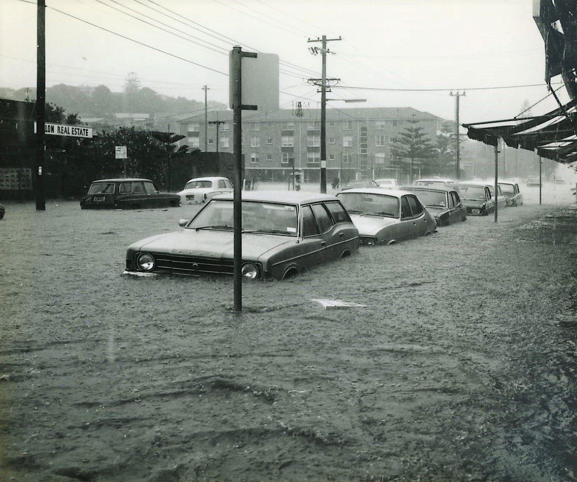
Photos courtesy John Stone and ABHS
Giles Stoddart of Avalon Honey:
I lost two of my colonies of bees when Careel Creek flooded in March 2022 during heavy rains and a king tide that meant there was nowhere for the rain to go except into people’s gardens and houses. I have a couple in North Avalon that host hives for me in their back garden, which backs on to Careel Creek. We had agreed on a location for the bees which was away from the house, and unfortunately the garden flooded very quickly before I could get there to move the hives. I was devastated and I tried to save the colony, but despite many thousands of bee surviving the flood and me giving them a new dry home with food, they never really became strong enough to survive the cooler Winter weather.
Avalon Honey's Giles trying to save his bees:
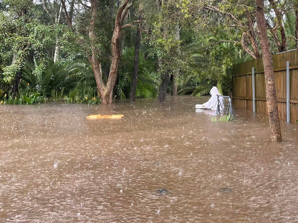
In May 2024 the valley of Avalon and Bilgola Plateau has been reminded this week that it was once a marshy floodplain called 'Priests' Flat' alongside the beach from Kamikazee corner to the mangroves of Careel Bay and that even though those water channels may now be funnelled into concrete pipes, they may still reappear during prolonged downpours of rain.
The NSW HRLV provides under Volume 4828, Folio 108 from when Angophora Reserve was handed to the community by A J Small - note the marked water courses, or creeks::
%20Vol%20Fol%204828-108.png?timestamp=1659822451523)
In February 1931 the formalisation of the dedicating the Bilgola Plateau parks from the same gentleman is recorded in Vol-Fol 4469-13, over 5 acres all up, which included some of the well-known Bilgola Plateau parks:
.jpg?timestamp=1714593544979)
.jpg?timestamp=1714594261697)
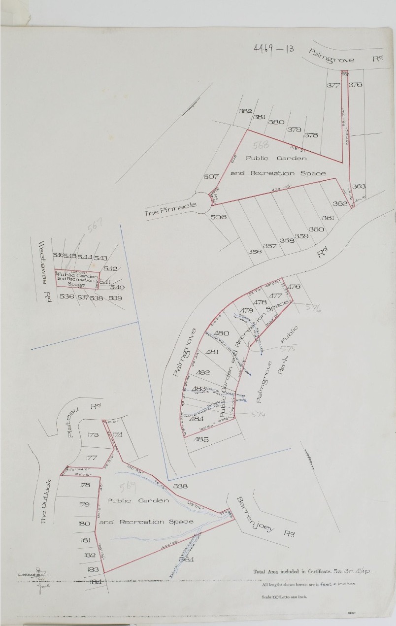
Note the creeks threading through these parks - the same is in the landscape at Angophora Reserve and Hudson Park (dedicated later as a public reserve, in 1957) during this era, as shown when that was formally gifted by A J Small and had the Wildlife Presrevation Society as Trustees, and in Dunbar Park, when that was gifted as well: