On Friday June 10, 2022 the NSW Department of Planning announced the department has completed its planning work for Ingleside and will not be proceeding with the Ingleside Place Strategy.
''The draft Ingleside Place Strategy was exhibited from 25 May to 23 July 2021.
Thank you to everyone who provided feedback and made submissions, which have informed our decision not to proceed with the place strategy.
The department acknowledges the cost of providing infrastructure and acquiring land for water management, flooding and riparian corridor protection affects the viability of delivering homes in Ingleside.'' the Department said in a statement.
You can find out more about the place strategy exhibition in our Consultation Outcomes Report (PDF, 661 KB). The exhibition documents can be seen on the planning portal.
''Planning for Ingleside will now be led by Northern Beaches Council, as part of the Northern Beaches Comprehensive Local Environmental Plan (LEP). The department will help co-ordinate input from state agencies.'' the Department said
In total 922 submissions were received, 897 were sent by the community, predominantly residents and 16 from community groups within the area, with the bulk of these opposing the proposal. Concerns expressed in feedback included: Infrastructure (insufficient), Emergency evacuation routes(in the event of bushfires), Environmental considerations, Retaining the local housing character and Maintaining the semi-rural bushland character of Ingleside.
Council welcomed the announcement that the NSW government will no longer be pursuing the development of Ingleside as a growth area.
Mayor Michael Regan thanked the government for listening to Council and the community.
“This news will be very welcome by many in our community and it’s great to have more certainty now for the future of this area.
“Planning for Ingleside will be handed back to Council and we’ll consider it as part of the development of our new Local Environmental Plan which we are working towards for the whole Northern Beaches area.
“However, we will not be considering any new housing development of the scale proposed by the government given we now have all the studies to demonstrate the significant bushfire risk, the environmental and Aboriginal heritage impacts and the need for costly infrastructure in order to make such a development feasible.”
Mayor Regan said Council would continue to advocate for the NSW Government to transfer into Council ownership, at no cost, the NSW Government land on which planning infrastructure is sited and ask the government to transfer surplus NSW government land for other public purposes such as sports fields, passive recreational spaces and biodiversity offsets.
“We now have an opportunity to repurpose some of this less environmentally sensitive land for broad community use.”
The revised draft Ingleside Place Strategy went on exhibition with feedback closing in July 2021. The Ingleside Precinct, as part of the Greater Sydney Commission commitment to accelerate development as part of a plan for meeting anticipated housing requirements, commenced mid-2013. A draft Land Use and Infrastructure Plan was exhibited from December 2016 until 28 February 2017, the target being for the Housing of 9000 thousand more people in 3500 more dwellings.
On November 28th, 2018 the State Government announced the proposed development plans for Ingleside would not proceed after an independent bushfire risk assessment found the 2016 draft plan would put future residents in danger. Department of Planning and Environment’s Acting Deputy Secretary, Planning and Design, Brett Whitworth, said then the safety of residents is of paramount importance.
“Above all, we need to ensure the safety of residents at Ingleside,” Mr Whitworth said.
“During consultation, we heard loud and clear that bushfire risk and mitigation was a key concern to residents in the area. We listened and responded to these concerns, by going back and relooking at the way we were planning for bushfire protection in Ingleside,” he said.
An independent assessment was undertaken, including a peer review of previous studies and report on bushfires in the area and in line with the latest research and NSW Rural Fire Service (RFS)’ latest risk assessment requirements. The report found the draft plan would put the community at risk.
Mr Whitworth said the Department have halted plans at this stage to work with the Council and NSW RFS.
“We need to ensure we have the right evacuation measures in place for current and future residents – especially in the context of other nearby areas such as Elanora Heights, Warriewood, Bayview and Church Point,” he said.
“This evacuation assessment, as well as consultation with landowners will help determine whether any further development could safely exist in the area.
“Any development would need to be at a much lower scale and we would need a guarantee that the road network could handle the extra development in the event of an evacuation.''
The revised draft Ingleside Place Strategy aimed to provide:
- Up to 980 new dwellings with a mix of dwelling types including houses on larger lots, low rise apartments and townhouses;
- A local community hub and shopping centre;
- Attractive and welcoming public areas that positively contribute to Ingleside’s character;
- Public open spaces including attractive streetscapes;
- Better pedestrian and cycling connections;
- Enhanced ecosystems and green spaces for people to relax outdoors;
- A model resilient, sustainable and low-carbon community; and
- New development only in areas that allow for effective and safe evacuation in the event of a bushfire.
The existing minimum lot size over most of Ingleside is 20,000 m2, or 2 ha. This coincides with all RU2 – Rural Landscape land. Areas retaining the RU2 – Rural Landscape zone will retain this minimum lot size
The 2021 draft Place Strategy proposed:
- R2 – Low Density Residential: minimum lot size of 450 m2
- R3 – Medium Density Residential: minimum lot size of 225 m2
- R5 – Large Lot Residential: minimum lot size of 1,500 m2.
An existing maximum height of 8.5 metres applies to most of Ingleside. This is largely retained in the bulk of the land area allocated for the proposal apart from a 10.5 metre control in the proposed R3 – Medium Density Residential zone as well as the areas covered by the SP2 and B1 zones as focussed on the location for neighbourhood shops to allow for apartments and townhouses.
Opposition to aspects of the plan was strong in the community, leading to the formation of the Residents Against Inappropriate Developments In Ingleside (RAID) group, from a number of local residents, environment and wildlife organisations, as well as being opposed by Council.
Among their concerns are a bushfire evacuation modelling that does not take into account volumes of traffic that would be created from surrounding suburbs and a bottleneck on the proposed route, no real fauna thoroughfares, and even a glaring gap between the currently being built fauna pass from Katandra Bushland Sanctuary connecting to a pathway for wildlife in Ingleside, a razed earth plan for the environment which would wipe out two Endangered Ecological Communities present and kill the animals these support, along with the $ contribution cap on each new proposed home not meeting infrastructure needs – a hole that ratepayers across the LGA may be expected to fill.
The Northern Beaches Council voted to reject the draft Ingleside Place Strategy on July 28, 2021, raising a number of serious issues which need to be considered by the NSW government.
Council noted the significant concerns of continued bushfire risk, lack of traffic and transport planning, the significant cost to ratepayers to provide the most basic of infrastructure, significant impacts on biodiversity and the ability to deliver any affordable housing in line with Council's adopted policy.
Council stated it would raise these issues in their submission to the NSW Department of Planning, Industry and Environment and also write to the NSW Planning Minister requesting that the NSW Government transfer into Council ownership, at no cost, the NSW Government land on which planning infrastructure is sited.
Council would also ask the government to transfer surplus NSW government land for other public purposes such as sports fields, passive recreational spaces and biodiversity offsets if the draft Ingleside Place Strategy does not proceed.
Mayor Michael Regan said then the Council understood the original vision behind Ingleside Place Strategy, but questioned if it was still the right approach given the scale had been greatly reduced due to the inherent bushfire risk.
“The bushfire reports clearly rules out development north of Mona Vale Road – we have to put safety first.
"However, we have a proposal for only 980 dwellings which will require a huge infrastructure investment. This will result in a very high development contribution rate for each dwelling and potentially become a financial burden on Council and our ratepayers.
"Aside from this key feasibility issue, we have identified a range of other issues.
“There are deficiencies in the environmental studies which need to be addressed. We are also seeking support our and the government’s sustainability goals to reduce carbon emissions and manage energy, water and waste efficiently.
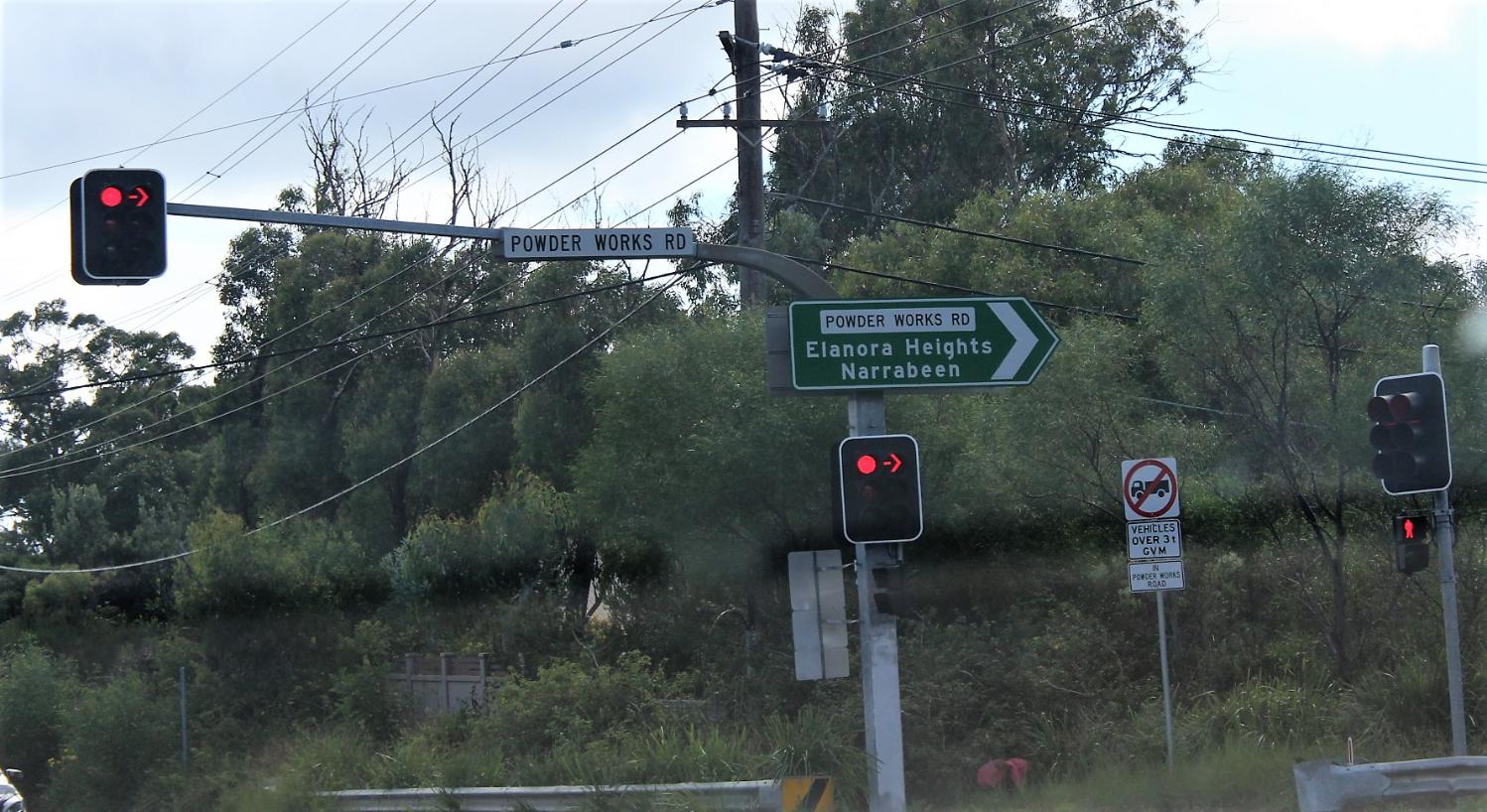
“Our submission also contends that the full impact of the bushfire evacuation needs to have greater regard for the impact of the existing bushland adjacent to Powder Works Road and other evacuation routes and more traffic modelling is required.”
Overall Council’s submission listed the key areas of concern with the draft strategy as: emergency bushfire evacuation; sustainability and resilience; water cycle management and flooding; biodiversity and wetlands protection; Aboriginal heritage and the provision and funding of suitable infrastructure capacity.
In the Biodiversity Assessment prepared for the Department of Planning the report notes that Accessibility was a key limitation. The ability to validate vegetation communities or targeted surveys for threatened flora and fauna species was limited to areas where property owners provided access. The document notes that therefore there is potential that habitat within land which was not accessed may provide suitable habitat for threatened species and Endangered Ecological Communities (EECs).
The Coastal Upland Swamp community listed as endangered under both the BC Act and EPBC Act was found in areas that could be accessed.
The report states that;
''This vegetation community is highly unique as it is one of two hanging or upland swamp communities recorded within the Sydney region (OEH 2013). The vegetation is located at high elevation up to 600 m above sea level. Water seepage is an important feature for this community as it is a groundwater dependent ecosystem (GDE). As such this community is often located at headwaters of creeks on impeded soils. There are several patches of this community scattered within the Precinct. A large patch is located between Manor Road and Powderworks Road and another large patch which extends outside of the Ingleside Precinct, within the north-western aspect in the grounds utilised by the Ingleside Scouts.''
Additional investigations of areas initially mapped as PCT 882, identified additional patches of Coastal Upland Damp Heath Swamp, which forms part of the Coastal Upland Swamps EEC, within the Precinct.
Species credit flora and fauna species under Biodiversity Assessment Method (BAM) found a total of 34 candidate species credit species were identified, of which 13 are flora species, and 21 are fauna species. Of these, 10 threatened flora species and 19 fauna species are also a listed Matters of National Environmental Significance (MNES) under the EPBC Act.
The document states that;
''These species and their biodiversity risk weightings which are the species sensitivity to loss or sensitivity to potential gain are summarised in Table 7. A very high biodiversity risk weighting means that a species cannot withstand loss and is at risk of extinction. These entities are also known as candidates for Serious and Irreversible Impacts (SAII) under the BAM. The higher the risk weighting the larger offset is required (i.e. the higher the weighting, the larger the offset that is required).
The Biodiversity Risk Weighting will be relevant to credit calculations, to be performed when development applications are submitted. The credit calculations will be based on the number of individuals impacted for threatened flora species and the area of habitat for threatened fauna species consistent with the BAM.''
Of those listed [Final species credit species and MNES list for Ingleside Precinct ] the following plants are noted as (SAII) very high; Persoonia hirsuta (hairy geebung), Microtis angusii (Angus's Onion Orchid), Hibbertia puberula.
Those listed as moderate (SAII); Callistemon linearifolius, Darwinia biflora, Epacris purpurascens var. purpurascens, Eucalyptus camfieldii, Lasiopetalum joyceae, Leptospermum deanei, Melaleuca deanei, Tetratheca glandulosa.
Wildlife species under the same criteria lists as 'moderate'(SAII); Callocephalon fimbriatum (Gang-gang Cockatoo) breeding, Calyptorhynchus lathami (Glossy Black Cockatoo) breeding, Chalinolobus dwyeri (Large-eared Pied Bat) breeding, Haliaeetus leucogaster (White-bellied Sea Eagle), Hieraaetus morphnoides (Little Eagle) breeding, Lophoictinia isura (Square-tailed Kite), Ninox connivens (Barking Owl) breeding, Ninox strenua (Powerful Owl) breeding, Petaurus norfolcensis (Squirrel Glider), Potorous tridactylus (Long-nosed Potooroo), Tyto novaehollandiae (Masked Owl) breeding, Tyto tenebricosa (Sooty Owl) breeding, Heleioporus australiacus (Giant Burrowing Frog), Pseudophryne australis (Red-crowned Toadlet), Phascolarctos cinereus (Koala), Cercartetus nanus (Eastern Pygmy Possum), Myotis macropus (Southern Myotis) breeding, Varanus rosenbergi (Rosenberg's Goanna).
The wildlife species listed as high to very high in the (SAII) are; Anthochaera phrygia (Regent Honeyeater - very high ) and Lathamus discolor (Swift Parrot - very high) breeding, Hoplocephalus bungaroides (Broadheaded Snake - high), Petalura gigantea (Giant Dragonfly - high).
The report notes that in the case of the Swift Parrot and Regent Honeyeater they may only be foraging during migrations. Both these birds are now listed as critically endangered.
This indicative list for its purposes, as this is by no means all the species of plants and animals that exist here, also reads a little like a nursery of these other residents will be destroyed, along with all its babies ('you are only moderately extinct'). It also underlines how biodiversity rich and made beautiful thereby Pittwater is, along with how much remains unseen and unchartered, still. This also begs the question of how 'offsets' could ever replace, or return, this unique environment.
When the announcement was made on Friday, June 10, 2022 Pittwater Online News posted the announcement on its social media platforms with a very positive response from residents, apart from those who would have benefitted financially from the development, some of whom were quick to buy any available parcels of land, at inflated prices, expecting to cash in.
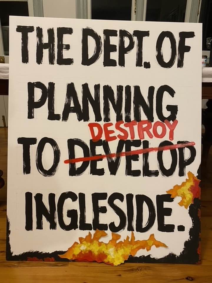
Example of RAID Rally poster - image supplied.