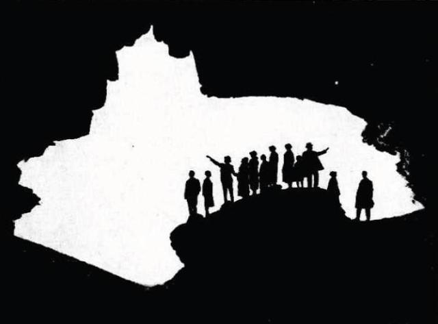
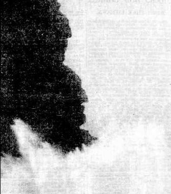
ST. MICHAEL'S CAVE, AVALON BEACH. MEMBERS OF THE ROYAL AUSTRALIAN HISTORICAL SOCIETY INSPECTING THE CAVE ON SATURDAY.
The spot was named by Archpriest Therry, who, it is stated, intended to erect a chapel in the cave.
Picture: ST. MICHAEL'S CAVE, AVALON BEACH. (1926, August 23).The Sydney Morning Herald (NSW : 1842 - 1954), p. 14. Retrieved from http://nla.gov.au/nla.news-article16329630
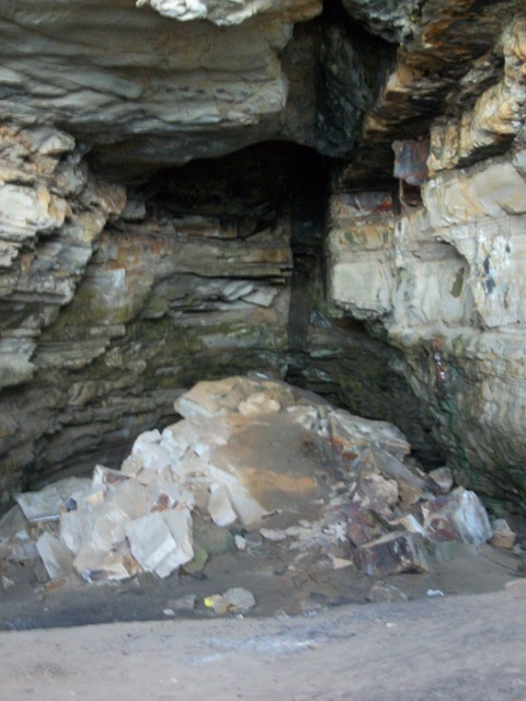
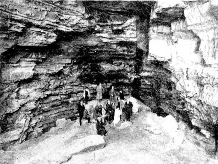
Above: Inside St Michael's Cave, February 2012
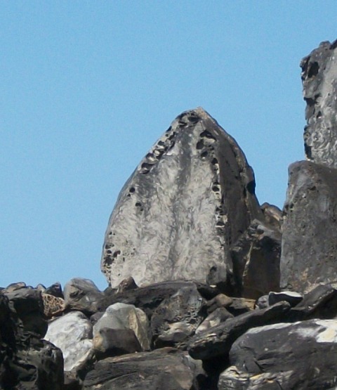
Current Stone 'Arch' window
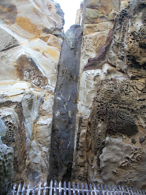
Above Entrance
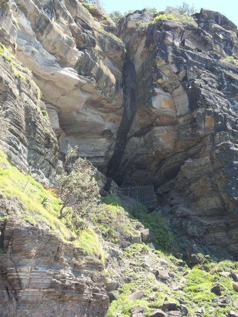
Sheer Cliff leading up to
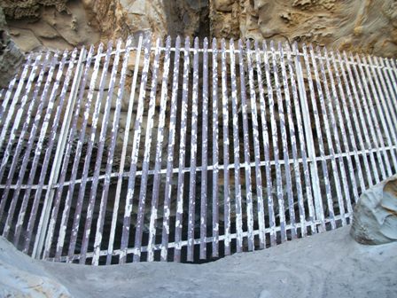
Fenced
Depression era Tragedy:
SWEPT OFF ROCKS. Fisherman Drowned.
James Wise, an unemployed carrier, was swept from the rocks at Avalon on Saturday and despite the attempts of a friend to save him was drowned
wise, with his wife and three children, was camping at Pittwater, and was earning his living by fishing. With another man, James Williams, he was fishing on Saturday off the rocks at Avalon at a spot called "The Hole in the Wall " The sea was rising, and waves were breaking over the men, and Williams suggested that they should move to a higher place. Before Wise could move, a wave swept him away Williams swam out, and struggled to bring Wise ashore for almost 20 minutes A wave separated them, and Williams was too exhausted to succeed in another attempt at rescue. Narrabeen police were informed of the tragedy, but the body had not been recovered up to lost night.
SWEPT OFF ROCKS. (1932, November 28). The Sydney Morning Herald (NSW : 1842 - 1954), p. 9. Retrieved from http://nla.gov.au/nla.news-article16933805
Joseph-town Estate for Sale
JOHN DAVISON and SON, Pitt-street, Solicitors of the Estate. PRELIMINARY NOTICE. PITTWATER. VALUABLE AGRICULTURAL FARM and GRAZING ESTATE, also the UNSOLD portions of BRIGHTON ESTATE, JOSEPHTON, in area about
2000 ACRES, more or less, now in the occupation of JOHN COLLINS,* Esq. It is bounded on the east by tho PACIFIC OCEAN, on the west by the BEAUTIFUL Bay of PITTWATER, on the SOUTH partly by a GOVERNMENT RESERVE and FARRELL'S FARM, and on the north by the BASSETT DARLEY PROPERTY. The Farm, as regard quality of soil is equal to any other in this rapidly improving and truly attractive district. It is 14 miles distant by a good road from the PIER at MANLY BEACH, and only 2 miles from Custom-house Station, at BARRENJOEY. Steamers ply regularly between Sydney and Pittwater, three times weekly, and coaches leave Manly every other day, which will set passengers down at BOULTON'S within 3 miles of the ESTATE.
RICHARDSON and WRENCH have received instructions to sell by public auction, at the Rooms, Pitt-street, Sydney, on an early day in FEBRUARY next.
The above extensive and valuable Estate, in LOTS TO SUIT PURCHASERS, also Allotments at Pittwater, day of sale, and full particulars of which will shortly be published. A large auction plan of the subdivision is row in course of completion, and will be ready for inspection in a few days, at the Rooms, Pitt-street.
'Messrs. ELLIS and MAKINSON, Elizabeth-street, are Solicitors of the vendors._
Advertising. (1880, January 31). The Sydney Morning Herald (NSW : 1842 - 1954), p. 14. Retrieved December 16, 2011, from http://nla.gov.au/nla.news-article13449984
THE PITTWATER ESTATE, subdivided as follows :
NORTH DIVISION.
FIVE CHOICE FARMS. - No. I., area 101a. Ir. 22p. II., ditto 70a. 2r. SOp. III., ditto 128a. Ir. 3»p.IV., ditto 85a. Or. S2p. Each of those have frontages to the PACIFIC OCEAN and the MAIN ROAD to BARRENJOEY. On LOT in. is the HOMESTEAD and RESIDENCE now in the occupation of JOHN COLLINS, Esq., and also the CELEBRATED CAVE.
Advertising. (1880, April 17). The Sydney Morning Herald (NSW : 1842 - 1954), p. 14. Retrieved December 22, 2011, from http://nla.gov.au/nla.news-article13458198
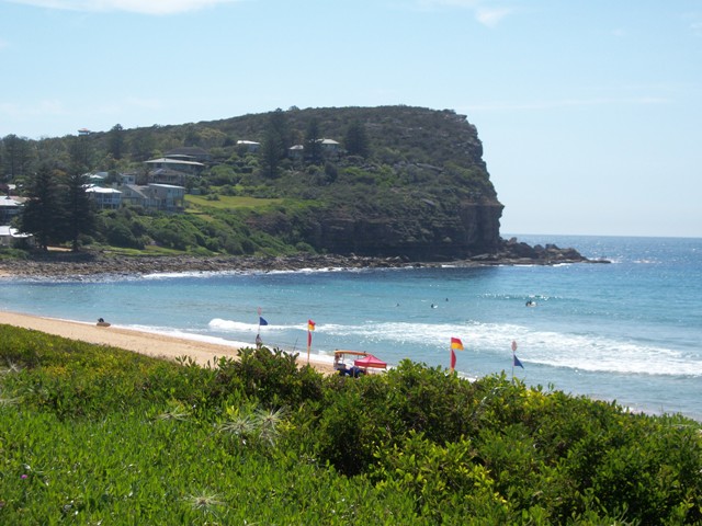
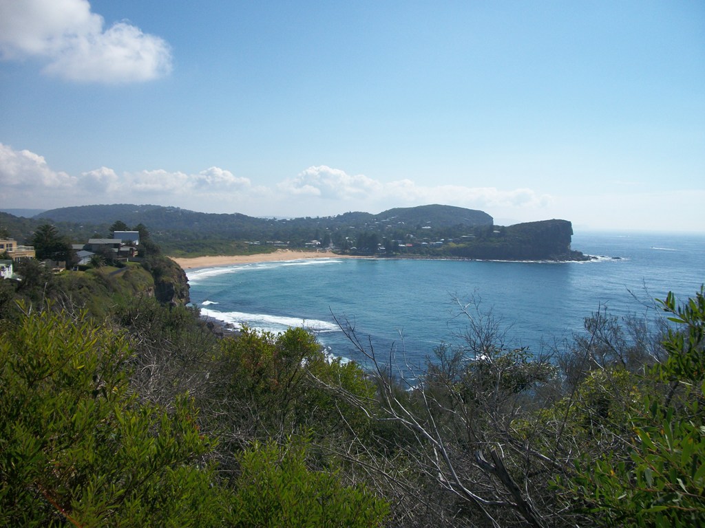
Avalon Headland: St Michael's Cave
Every headland in Pittwater has unique silhouettes that make them identifiable, and the places they mark ensure a pilot, boat captain or walker who knows of them by sight will also then know where they are. To close our month of Pittwater landmarks we go east to North Avalon headland as its landscape has features still present and unusual landforms now gone or dangerous to access that encompass its land and seafronts.
Tucked closer to Bangalley headland then the northern point is St Michael’s Cave, now fenced off due to the landfalls within the cave and the cliffs above it that make it dangerous to visit. Residents need only recall the tragic accident that occurred on 21st of February 2004 on Bangalley Headland where a huge sandstone block two tourists were standing on slipped, crushing and killing one who fell with it instantly. The other was fortunate to fall backwards.
A recent walk to St Michael’s cave instilled a sense of calm on approach but the danger inherent in climbing the sheer and sandy hill leading up to the mouth and the massive blocks of sandstone meeting over one’s head is quickly communicated by the landscape itself. The cave’s name came from Archpriest Joseph Therry and was part of a land grant of 1833.
"in pursuance of a promise made by Sir Thomas Brisbane, and granted by Governor Bourke on the 31st August, 1833." (OBrien.1922. P.279) acreage was given to Father JJ Therry and By virtue of a promise made by Sir Richard Bourke in 1835 a further grant of 280 acres adjoining was made on 11 February, 1837. In 1836 he purchased from private owners 10 acres at the head of Narrabeen Lagoon. The land at Pittwater still bears the name of the "Priest's Flat." Here he placed Dr. Bergin, who superintended the cultivation of the land; and the foreshores produced shells, which were used for lime. Father Therry's nephew recalls how shiploads of shell were sent to Sydney, and there sold.
Father Therry planned to establish a chapel on the cliff above, although some sources state he intended to have a church within the cave itself and conduct Lectures and Services in the cave's room. In another stone structure on the rock shelf outside this large natural room, swept away in a storm in 1950(?) and called until then ‘The Pedestal’ he saw a natural pulpit. A little further south a stone archway, also washed away by storms, indicated to Therry, as it had long to our original custodians, the sacredness of this place. Photographed while 'treading this path' as part of the research is another unusual stone shaped alike an arched church window. (see left)
Numerous visits to this cave formed part of any excursion to ‘Pitt Water’ during this time;
PITT WATER.
Yesterday, being Easter Monday, a pleasant steam excursion took place in connection with the St Benedict's Young Men's Society. The commodious steamer the Collaroy, under the command of Captain Mulhall, had been chartered for the occasion, and left the Australasian Steam Navigation Company's Wharf, Sussex-street North, with about 260 persons on board, at ten o' clock a.m. Part of the band of H. M. S. 12th Regiment were in attendance, their cheerful and untiring efforts contributing not a little towards making the day pass harmoniously and agreeably away. Working along through the everchanging scenery displayed on the shores of our harbour, the Collaroy at length rounded the Heads, and, taking a northerly course, rushed past that enormous barrier presented by the weather-worn cliffs which face the ocean between the Great North Head and the seaward aspect of Manly Beach. Following on the interesting coast line of Curl Curl, Dee why, Long Reef, and Narrabeen, &c, - varied succession of wooded eminences, long sandy reaches, towering precipices, and grassy park-like slopes, - the pleasure-seekers were at length abreast of the singular headland of Barrenjoey, forming the extreme south-eastern limit of the estuary which serves as a common outlet for the River Hawkesbury and the Pitt Water. Shortly after passing the Custom House station the course of the Collaroy then took a southerly direction, and so brought the holiday folks into the lake-like solitudes of Pitt Water, until wooded hills seemed to be rising on every side of the vessel. The passengers were landed at a small, but commodious wharf, erected on the property of the Venerable J. J Therry, under whose especial patronage the excursion had been got up. Most of the visitors set off in quest of St. Michael's Cave, determined not to lose the opportunity of seeing so great a natural curiosity. The walk, it was found, lay through woods, a long flat, and a hilly scrub, until, facing to the east at the head of the inlet, the merry party, in a straggling Indian file, at length arrived in the vicinity of the cave, cautiously descending the rocks, and creeping carefully along a narrow path specially made for their convenience on the face of the cliffs, they were thus finally rewarded for their perseverance. Almost every body managed to scramble up into the cave, and not a few of the more adventurous explored its inmost recesses by candle-light. The effect of the gloomy inner arch looked down upon from the top of the second angle of the cave, was much admired; and so also was the wider arch at the entrance, as contemplated from the spot where the bright daylight again began to stream down upon the faces of the returning explorers. There was, for some time, a pleasant buzz of conversation and a discussion of food at the mouth of St Michael's Cave, and then the party set out on their way back to the steamer, where dinner had been prepared. Some with sharpened appetites posted thither at once, but many remained with the band near the house on the flat, and amused themselves with dancing, playing cricket, and so on. There was some dancing also at the steamer after dinner was over. The Kembla steamer visited the wharf at an early hour, landed some passengers, and afterwards returned for them. The Collaroy left the wharf for Sydney at about five o'clock, and arrived safe at Sydney soon after eight. The Right Worshipful the Mayor of Sydney, the Mayoress, and other members of the family were on board. We also observed the Rev. Fathers Corish, Curtis, Hanson, and Powell, besides the Venerable J. J. Therry. The trip appeared to give general satisfaction, although a slight shower, soon after the arrival of the Collaroy at Pitt Water, interfered with some of the arrangements.
PITT WATER. (1862, April 22). The Sydney Morning Herald (NSW : 1842 - 1954), p. 4. Retrieved December 6, 2011, from http://nla.gov.au/nla.news-article13227471
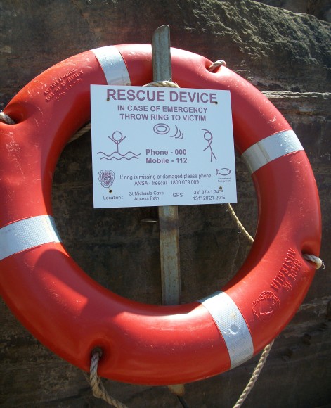
The shelves of rock outside this cave are subject to crashing ocean waves even at low tide in a low swell. The lifebelts that are fixed to cliff faces around this platform today bear testament to how dangerous it may be, even for those experienced with the area when fishing. To imagine dealing with tides and cliffs to get to and from church may have been a good reason not to go ahead with plans to hold services there.
Therry had cause to begin selling portions of this estate by 1862 and voiced, as part of these plans, a wish for the environs surrounding this headland to remain untouched;
At the end of 1862 Father Therry contemplated selling the Pittwater Estate. The scheme of subdivision was again ambitious. Mr. Elyard, the Surveyor, recommended that "a sufficient portion may be reserved near the water, and possessing the sea breeze, for Public Gardens and games; and also, sites for a School of Arts, Library, Court of Justice and Christian churches. I trust that the trees near St. Michael's Cave may not be touched, and that that spot may not be interfered with by human hands. I think this is the proper way of establishing a city at Broken Bay, and I shall have great pleasure, for my own part, in acknowledging you as its first Bishop." The plan of subdivision was eventually drawn up. The district was to be called Josephton, and the township Brighton. The land was sold in May, 1880. The city of Brighton, and the diocese of Josephton, may come in the future. (O’Brien.1922.P.280).
St Michael’s Cave continued to attract visitors
AVALON BEACH. HISTORICAL SOCIETY'S VISIT.
Members of the Royal Australian Historical Society on Saturday visited Avalon Beach, between Newport and Barrenjoey, and inspected some of the historic spots in the district. The party was escorted by Mr. Arthur J. Small.
Among the places visited was Bilgola, the beautiful home of Mrs. Maclurcan, which has been erected on the site of the residence of William Bede Dalley, who was prominent in the political life of the State 40 years ago, and who took the initiative in the despatch of the New South Wales contingent to the Soudan. The building is surrounded by tall palms, planted during Mr. Dalley's occupancy of the original cottage.
The site of a coal bore on Avalon golf links was inspected, and St. Michael's Cave, on the Seashore, was viewed by the party. The latter spot was named by Arch priest Therry, who, it was stated, intended to build a chapel in the cave.
At the conclusion of the visit Captain J. H. Watson, president of the Royal Australian Historical Society, on behalf of the visitors, thanked Mr. Small for the visit. AVALON BEACH. (1926, August 23). The Sydney Morning Herald (NSW : 1842 - 1954), p. 10. Retrieved from http://nla.gov.au/nla.news-article16329547
Its structure and geological formation has attracted many studies;
COAST STRUCTURE. Cronulla to Barrenjoey.
(BY PROFESSOR GRIFFITH TAYLOR.)
Behind the great beach of Cronulla at its south-end is a line raised shoreline, which Is the result of this upward Joggle. So also the most striking erosion feature of our coast-Saint Michael's Cave at Avalon-was certainly largely cut by the waves, though now a shelf of rock keeps out all action of the sea. Thus we see that the dominant feature of the coast has been a drowning of about 200 foot-but this has been followed by a less striking uplift of about a dozen foot.
COAST STRUCTURE. (1928, March 3). The Sydney Morning Herald (NSW : 1842 - 1954), p. 13. Retrieved from http://nla.gov.au/nla.news-article16446582
Many saw in its shapes and silhouettes the outlines of Australia itself:
THE VALE OF AVALON. Its Varied Attractions. (BY M. M. CAMPBELL.)
Of all the many beautiful beaches abounding within reach of a short car run from Sydney, surely there is none, which for sheer loveliness, can compare with Avalon. As one tops the rise above it on the road from Newport, the eye rests with delight on the exquisite picture that it forms. Backed by a dense growth of Angophoras and other native trees which clothe the hills behind it, the vale itself lies green and restful, and leads the eye down to the golden crescent of the beach. Beyond the rugged grandeur of the rocky point at the far end of the beach, green headlands run out to meet the ocean, and it is within one of these that a cave of unusual formation is to be found-the peculiarity of which is not observed from the outside; but walk a little way into its dim recesses, then turn and look back, and you will see etched upon the brilliance of the blue water by the outline of the dark entrance rocks,' an almost perfect reproduction of the map of Australia. THE VALE OF AVALON. (1934, April 7). The Sydney Morning Herald (NSW : 1842 - 1954), p. 11. Retrieved from http://nla.gov.au/nla.news-article17073748
In 1983 part of the cave’s roof collapsed and caused Warringah Council to have an assessment of the cave and its surrounding cliff face access assessed. The report returned by Coffey and Partners stated that the cave and steep paths to it were all dangerous and caused the Council to fence off the stone room in 1985. This fence was replaced by Pittwater Council in 1992 and remains intact.
 Further south, on the North Headland, yet more likenesses were noticed;
The rock formations on the cliffs at the northern end of Avalon beach bear a remarkable resemblance to human faces, and there are those who are able to imagine a likeness to Mr. W. M. Hughes and Mr. S. M. Bruce in them. From; HOME AGAIN FROM THE SEA—NEW ROYAL AIR FORCE BOMBING 'PLANE—PROFILES ON THE CLIFFS AT AVALON. (1936, July 17). The Sydney Morning Herald (NSW : 1842 - 1954), p. 14. Retrieved from http://nla.gov.au/nla.news-article17252446
Mr W M Hughes is William Morris (Billy) Hughes, a former Prime Minister of Australia (1915-1923). S M Bruce is Stanley Melbourne Bruce who took over the duties of Australian Prime Minister on February 9th 1923 so perhaps the SMH reporter who sees their faces so close to each other in Avalon’s headland is being a bit ‘tongue in cheek’.
Those of you whom view all the earth as a vision both sacred and living may already be familiar with the landmark known as North Avalon Headland and how a larger face, comprised of the whole headland itself, staring stoically out to sea and sky, appears from a side view when south and looking north. Whose face is that…St Michael's ? An Ancient Aboriginal Custodian's ? or just us, seeing ourselves in the land that may also perceives us?
O'Brien, Eris M. Life and letters of Archpriest John Joseph Therry, founder of the Catholic Church in Australia.1922. Angus and Robertson. Sydney, Australia. Pittwater; Pages: 278-9, 283, 284. Available at: http://www.archive.org/details/lifeandlettersof00obriuoft
St. Michael’s Arch, Avalon – 1864 to 1962
Do you ever wonder what the landscape looked like before you walked this way, or how the unending incoming tides may erode and change familiar sights to something quite unrecognizable?
It’s hard to imagine times we were not part of without looking closely at the dress, listening to the mannerisms of how people spoke, and looking at the places they once walked in – for instance, did you know when you walk behind Barrenjoey High School on that track beside Careel Creek that are actually walking on the Collin’s farmland and where their dam and dairy used to be?
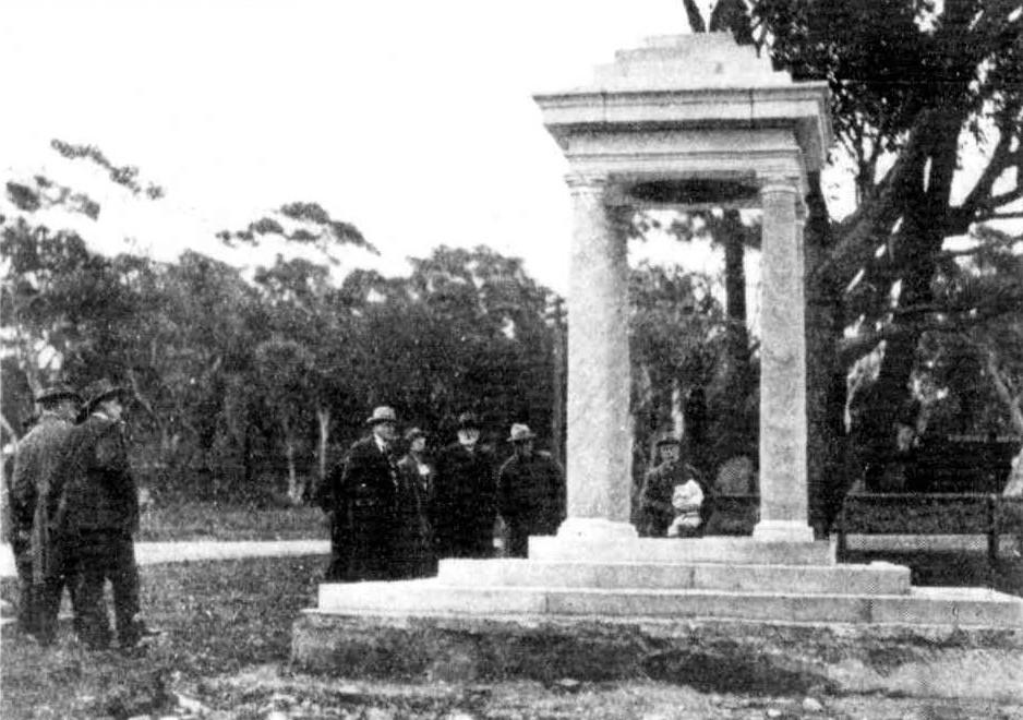
Or when at south Newport Beach – can you see where the bridge that crossed a lagoon that used to form there may have been and how it looked then? Or in this picture above of the Soldiers Memorial at Mona Vale Village park – see all the bush behind there where traffic lights and roads are now? Much changed, isn’t it?
Some places change without the human touch – this is one of these, and the only way we get to see how it may have looked is by doing a little research and charting how it has changed through over 150 years.
St. Michael’s Arch was one of those landmarks that may have been used by all the many coastal boats that used to carry produce from Pittwater and the Hawkesbury when using this way to transport crops and fish from what was essentially a rural area was much easier then trying to use tracks prior to the building of roads.
Geoff Searl of the Avalon Beach Historical Society tells us this arch had other names too - ‘Hole in the Wall’ (which it was in reality until 1867 when it lost the top of the arch). It was then called the ‘Pedestal’, the 'Stone Lady', ‘Lot’s Wife’ and the foreign legion soldier (before it lost the very top of the stone column) until around 1962 (our last reliably dated photo of the column). Geoff remembers the geological term of ’sea arch’ being used originally.
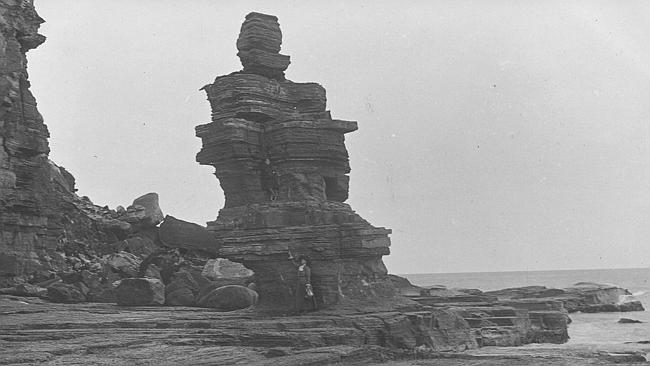
circa 1900 when 'the Pedestal'
Just a little further around the corner is another landmark – St Michael’s Cave, although this would not have stood out as much as the Arch did:
ST. MICHAEL'S ARCH.
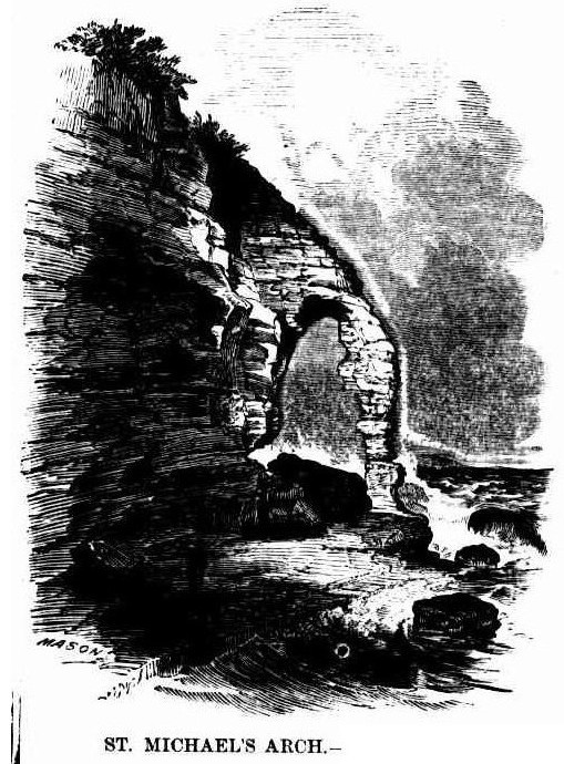 This beautiful Arch is situated on the estate of the late Very Reverend J. J. Therry, about three miles south of Broken Bay. As the scenery along. the coast from Manly Beach to the Bay is of the loveliest description, we advise all lovers of the picturesque to hire a spring cart from Mr. Miles - who lives about half a mile from the Pier Hotel - and proceed, early in the morning, to Mr. Collins' house, about thirteen miles distance, so as to be able to inspect this extraordinary specimen of natural architecture, and to return to Manly the same day if necessary.
As this excursion may gradually become fashionable, we quote a description of the places on the road from the late Postmaster- General Raymond's valuable work, the "Post Office Directory for 1855."
"Seven and a half miles from North Harbour, - Jenkins' house ; the road for the last mile along a level sandy beach. On the left is Narabeen lagoon. Mr. Jenkins has a snug house here, and much land in cultivation, which is an agreeable prospect - from the sea. Eleven and a half miles from North Harbour -Hut on the sea shore. The path from the Pennant Hills Road reaches the sea, and joins this coast road at the farm of one Foley - a tenant of. Mr. Wentworth's ; the distance from thence being twelve miles. About half a mile further on is the south-east arm of Pitt Water, on which there are some small cultivated farms. The head of Pitt Water as seen from the heights along which the road or path leads, is equal to any lake scenery, and there are many romantic spots, with good land, on its banks, which might be converted into good farms. Thirteen miles from North Harbour - Several farms and cottages. Fourteen miles- The Rev. Mr. Therry has a grant here. Fourteen and three-quarter miles - The Hole-in-the-Wall, being a rocky projection forming a rude archway with the shore."
The arch mentioned by Mr. Raymond is about twenty-two feet across the inside, and between thirty and forty feet high underneath. The rocks, of which it forms a part, are seventy feet in height - the colours of these rocks are exceedingly beautiful. At low water the visitor can pass through the arch.
Ascending the cliffs, a view of Pitt Water is beheld, being the harbour belonging to this estate. If an arrangement were madeto have a small steamer plying along the beautifully wooded, lofty, and precipitous shores of the Hawkesbury River, parties of travellers could meet it at this spot, avoiding the disagreeable sea voyage by coming from Manly by land. The steamer could convey them from Mr. Collins' house to Windsor, and the trainwould take them back to Sydney - it being understood that the Windsor railway will shortly be completed.
Illustration: ST. MICHAEL'S ARCH.
ST. MICHAEL'S ARCH. (1864, October 15). Illustrated Sydney News (NSW : 1853 - 1872), p. 3. Retrieved from http://nla.gov.au/nla.news-article63512130
St. Michael's Arch 1867 - The storm that turned an arch into a pedestal:
BROKEN BAY. [From the Herald's Correspondents.]
June 24. — We have had tremendous weather, but, as far as Pitt Water is concerned, no damage has been done, with the exception to one of our picturesque curiosities, St. Michael's Arch. It has at length yielded to the too mighty elements and the destroying influence of time,— that which, was the admiration of all who have beheld it is now almost a baseless fabric,— there is only about one half of the outer support left, looking at it at a distance it has the resemblance of a colossal pillar. In its fall it carried a large portion of the overhanging rock with it, a thousand tons of gigantic boulders, and in such masses that I think it will stop the ingress from that part to the cave, but as yet we have had no close inspection, for the rollers are dashing to the height of the stupendous rocks. The only idea I can give of the gale is, that the froth of (not spray) the sea came over Mount St. Joseph, opposite the house, half a foot in size, and spread itself down to the dam, at times shading the heights of the mountain, — its resemblance was that of an overwhelming snow storm. The sea at Barranjoey washed away the flower garden in front of the Chinamen's huts, taking soil and all, so that the beach comes close up to their door. There must have been awful havoc in the Hawkesbury, for all the beaches from Barrenjoey to the Long Reach are strewed with fragments of houses, boxes, chairs, doorframes, dead pigs, hay, wheat, broken bedsteads, weatherboard sides of houses, oranges with large branches, pumpkins, melons, corn cobs, and other debris, that scarcely any portion of the beaches can be seen. Mr. Conolly picked up a workbox, in which was contained a number of receipts and letters directed to Mr. Moss, Windsor. The beaches on which are the debris is Barrenjoey, Whale Beach, Collins's Beach, Mick's Hollow Beach, Farrell's Beach, Mona Beach, and Long Reach, so it may be imagined the great extent of destruction. BROKEN BAY. (1867, June 29). Sydney Mail (NSW : 1860 - 1871), p. 11. Retrieved from http://nla.gov.au/nla.news-article166799304
Many resident historians are fairly certain that the above was written by then resident in this region John Collins, or his brother Frank, who worked occasionally at the Broken Bay Customs Station, Barrenjoey headland during these years. Mr. Conolly, who is also mentioned, became a relative by marrying one of the Collin's ladies.
The stone itself was composed of soft sandstone, which doesn't do too well under a constant onslaught of sea and wind. Today there is very little left of any of this stone, you would need to compare the pictures to see what remnant remains. Another storm, and its effects, gives you some idea of the quirks of ocean, tide and wind and how they affect what places look like:
Surf Full Of Melons - Hundreds of big jam melons that had been carried out to sea by the Hawkesbury River flood, were washed up in the surf at Avalon Beach yesterday. Most of them were in sound condition despite their long journey - possibly 50 miles. They were quickly snapped up by scores of local residents and visitors. Mr. Ronald Hogg, who lives nearby, said that people went to the beach on foot and in cars and trucks, which they loaded with melons. Others staggered away with chaff bagsfull. Apparently the melons had been swept by floodwaters from farms along the upper parts of the Hawkesbury. Surf Full Of Melons. (1949, June 20). The Sydney Morning Herald(NSW : 1842 - 1954), p. 4. Retrieved from http://nla.gov.au/nla.news-article18119781
The cave named ‘St. Michael’s’ has had many stories written about it through the century and a half or more since its discovery – including being once slated for use as a chapel or meeting place for worship. For many years it was one of the places to visit for people coming to Avalon.
One recurring theme in these stories is how if you’re standing within it and looking out the silhouette looks slightly like a map of Australia – a very big landscape indeed – constantly changing by being an island always met by ocean waters:
Among the places visited by the members of the. R.A.H.S. was Bilgola, the beautiful home of Mrs. Maclurcan which has been erected on the site of the residence of William Bede Dalley, who was prominent in the political life Members of the Royal Australian Historical Society on Saturday visited Avalon Beach, between Newport and Barrenjoey. and inspected some of the historic spots in the district. The party was escorted by Mr. Arthur J. Small'. The site of a coal bore on Avalon golf links was inspected, and St. Michael's Cave, on the seashore, was viewed by the party. The latter spot was named by Archpriest Therry, who, it was stated, intended to build a chapel in the cave.
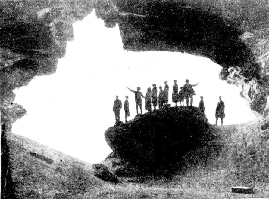
ENTRANCE TO ST. MICHAEL'S CAVE.
MEMBERS OF THE HISTORICAL SOCIETY IN THE CAVE.
A Week-End Miscellany : History, Charity, and Sport. (1926, August 25). Sydney Mail (NSW : 1912 - 1938), p. 10. Retrieved fromhttp://nla.gov.au/nla.news-article166523535
ST. MICHAEL'S CAVE — Avalon's Map of Australia
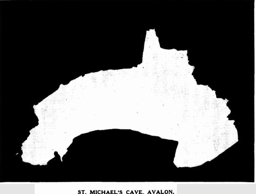
ST. MICHAEL'S CAVE, AVALON.
A SMUGGLER'S cave in Sydney? Yes!... St. Michael's Cave at Avalon —an ideal spot for an unusual picnic. Those who own cars can go direct; others, to Manly by ferry and then by motor-bus to Avalon. A scramble down the descending cliff face at North Avalon and a longish stiff walk over huge boulders honey-combed by the ceaseless action of the waves lead eventually to acave with a wide, gaping entrance. As the picture shows, it is almost a perfect reproduction in silhouette of the outline of Australia. This is not noticeable until you enter its portals and look seawards. Reputed to be the largest coastal cave in New South Wales, it is said to be capable of holding 2000 people. Its full length is about 325ft, tapering to a narrow point and ending in darkness. The highest point from floor to roof is approximately 30ft.
RECENTLY members of the Naturalists’ Society of New South Wales visited the cave, and Mr. A. J. Small acted as pilot and recalled its history. It appears that in 1833 the Rev. John Joseph Therry had a Crown grant of about 1200 acres in the Barrenjoey Peninsula, most of it then occupying what is now known as the district of Avalon Beach. This reverend gentleman founded the first St. Mary's Roman Catholic Church in Sydney, which, when burnt down some years afterwards, became the site of the present Cathedral. He is credited with the intention of building a chapel above the cave and constructing a passage to the subterranean cavity. This original plan never developed further than the idea and the name St. Michael's Cave, which he bestowed upon it. It is believed by some people that in later years enterprising smugglers accidentally discovered it and used it for their 'unlawful occasions,' quite unknown to the Rev. John Joseph Therry. Others say this is only a legend. Geologists love to delve into the black volcanic dyke which traverses the full length of the roof. This is the result of enormous pressure from unknown depths forcing it upwards. It makes a striking colour streak in the 'ceiling' —almost a modern art decor.
THE floor of the cave is well above sea level. The coastline in this locality has risen far beyond its former level during the ages, and portion of the roof falling in at different times has helped to build up the floor. Several huge boulders now furnish good picnic tables and seats, and gazing upwards you can see marks on the ceiling showing the line of detachment. Breathing an inward prayer that several overhanging projections will remain 'put' during your occupancy, you can picture what a fright the bats must have when these shocks happen. Today the cave with the land above is in the hands of private ownership. It has been suggested that it should be resumed by the State. On a wild stormy winter's day the honey-combed cliffs on the way to the cave, and the exceptionally rugged coast in the vicinity, give a picture of magnificent and unusual beauty. The grandeur of towering waves hurling themselves against the seemingly impregnable fortress of rock is a sight to behold. The naturalists, however, saw it in perfect weather, and the visit to St. Michael's Cave will always remain a memory of delight and adventure and romance in a ;calendar of many happy outings. — M. ST. MICHAEL'S CAVE. (1937, September 1). Sydney Mail (NSW : 1912 - 1938), p. 44. Retrieved from http://nla.gov.au/nla.news-article160498432
We have written a little more on St Micheal's cave (but be aware you cannot go in there anymore, it is considered too dangerous and has been fenced off). If you are going to go on the rock platforms at Avalon, please make sure you have an adult with you who knows about ocean tides. See: www.pittwateronlinenews.com/avalon-headland-landmarks-history
Avalon Headland Landmarks -threads collated by A J Guesdon, 2012.