Although the presence of fresh water in the form of a permanent spring or creek was a selling point when the big acreage lots were subdivided into urban holdings and sold off, from the 1920's and 1930's on those who had bought these blocks began asking the then Warringah Shire Council to place these creeks into channels and pipes - especially after rain events when the overflow inundated their properties.
There were at least 7 permanent creeks in the southern end of Avalon Beach and its valley prior to the urbanisation of this place. Residents who moved here in the 1950’s recall how the landscapes would flood from these creek-beds during heavier rains and inundate the shops, the camping area, and some homes.
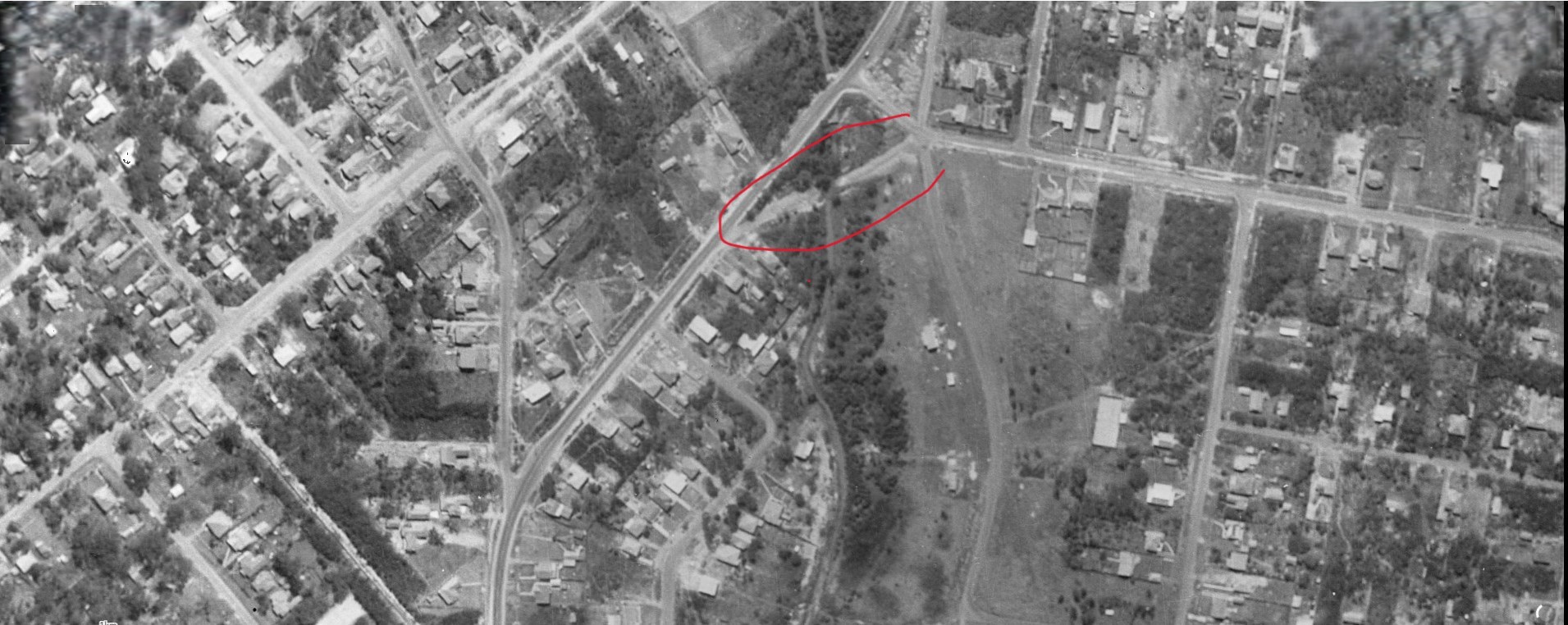
The waters at the south end, flowing through today's Angophora Reserve, or under Dunbar Park, would join in the Careel Creek channel and flow outwards towards Careel Bay. A pipe bursting in 2024 reminded older residents this is still a place of flooding drains that were former creeks, built on a coastal heath sandflat that is reclaimed mangroves at one end.
However, one generation prior to the great sell-off, a dam was built along Careel Creek to capture this flow of fresh water to serve the cows milked by the Collins family near current day Catalina Crescent.
That dam would still show as being in place into 1922 land sales. As a water supply extension to Avalon and Palm Beach wasn't officially resolved until December 1934, and sewerage was still being extended to streets here and north of here into the 1980's, a supply of fresh water, or access to springs and creeks, were vital in the shift from these landscapes being rural properties, to places for investment in acreage and then holiday homes, and then to suburban lots as the cost of these lands, and better transport and roads, made that feasible.
The Collins family, with patriarch John referred to as the 'Patriarch of Pittwater' in some accounts, had a connection with J J Therry, to whom much of this land was given in a land grant.
John Collins was the eldest son born to Jeremiah and Catherine Collins (Nee Roche) at Annakissy, Killavullen Parish, Ireland. Shelagh Champion OAM and George Champion OAM, in their Profiles of the Pioneers (2013 - Warringah Shire Library) state Jeremiah and Catherine had four known sons, John, Francis (Frank), William and Æneas and two daughters, Mary and Catherine. A US relative who has been researching this branch of his family also lists two of the Collins sisters, Margaret, who married Jeremiah Hartnett (also from Cork) in Sydney in 1846, and Ellen, immigrating to San Francisco at the height of the California Gold Rush in 1849. There are four other daughters listed in Church records, Bridget and Hanora, and two Mary's (one born in 1811 and the other in 1828). Of the 17 children the couple had baptised, only 12 were known to still be living when they embarked for New South Wales.
Phil Michelson of California on Jeremiah and Catherine: Jeremiah immigrated to Sydney, NSW with 12 of his children aboard the Elphinstone in 1840. He had been evicted from the Pierce Nagle Estate at Clenor even though he had paid his rent on time.
Many other tenants were evicted from the same estate during these years. The Elphinstone sailed into Sydney in October of 1840 - a check of the ships records shows only three of the sons aboard - John, Aenas and William. The Champion's research points to Jeremiah and Catherine arriving later:
Shipping Intelligence. ARRIVALS-YESTERDAY. ELPHINSTONE, barque, Friendlen, master, from London and Plymouth the 3rd of June, Gore and Co., Agents. Cargo-Merchandise. Passengers - Cabin - Mr. Capper, Captain Edinborough and Lady. Mr. Arthur Edinborough. Mr. Thomas Boyed. Intermediate - Mr. and Mrs. Levy,Mr. Forsyth, Mr. Hynd, Mr. Cullender, Mr. Gibbes, Miss Roach, and two hundred and forty-eight Emigrants, under the command of D.M. Salter, Esq., Surgeon. Shipping Intelligence. (1840, October 9). The Sydney Monitor and Commercial Advertiser (NSW : 1838 - 1841), p. 3 Edition: MORNING. Retrieved fromhttp://nla.gov.au/nla.news-article32185727
Ship News. By the Elphinstone from London, we have received 248 emigrants, who appear to be a most respectable set of people, and principally agriculturists. They have arrived in a healthy condition, notwithstanding that during the passage out, a slight case of fever was witnessed, which occasioned the death of four adults and six infants. This is the second vessel arrived from the firm of Carter and Bonus, and are sent out in addition to Marshall's emigrants. They consist of 158 adults, 28 children, between the age of seven and fourteen years, and fifty-five infants. The Himalaya, from London, bound to Port Phillip, with emigrants, was spoken by the Elphinstone, on the 11th September in lat. 38 ° 40' S , long. 90 ° 30' E., out 80 days, all well. The Mary Dugdale from Liverpool, bound to Adelaide with emigrants, and out 19 days, was spoken by the Elphinstone on the 29th of June, in lat. 8 ° N. Ship News. (1840, October 10). The Sydney Gazette and New South Wales Advertiser (NSW : 1803 - 1842), p. 2. Retrieved, from http://nla.gov.au/nla.news-article2539219
John Doyle, a relative of the Collin's had been transported for insurrection in 1823 according to family letters held by Mr. Michelson. The Irish Insurrection Act (1822) saw around 30,000 men and 9,000 women transported directly from Ireland. Apart from those from the cities of Dublin and Cork, the majority were from rural areas and were first offenders. Many were nationalists fighting British domination, or social rebels protesting against a harsh and unjust law which condemned them to poverty and starvation. [A G L Shaw]
Mr. Doyle, once he gained his Ticket of Leave here, became a Pitt Water tenant of Rev. J J Therry, who also hailed from Cork and was very keen to help those he saw as being harshly treated at home and just as harshly targeted here.
John Doyle drowned in Pittwater on January 20th, 1841:
INQUEST.-An inquest was held on Tuesday morning at the house of Mr. Murphy, the Sign of the Bard's Legacy, Queen's Wharf on the body of John Doyle, who was accidentally drowned by the upsetting of a boat at Pitt Water, on Wednesday, the 20th instant. The body was found at Broken Bay on Monday last by some fishermen,who brought it to Sydney. It appeared from the evidence that the persons who were in the boat along with deceased at the time the accident occurred, as well as deceased himself, were perfectly sober, and the jury returned a verdict of accidental death. THE REGATTA. (1841, January 28). Australasian Chronicle(Sydney, NSW : 1839 - 1843), p. 3. Retrieved from http://nla.gov.au/nla.news-article31730651
 COLLINS, Jeremiah: Hole in the Wall, Parish Broken Bay, County Cumberland, District Sydney.
The Collins family engaged in farming, with John Collins running the farm when his father Jeremiah passed away soon after the son named for him did:
FUNERAL. — The friends of Mr. Jeremiah Collins, Pitt Water, are requested to attend the funeral of his deceased son, Jeremiah, to move from the Ferry Wharf, Windmill - street, Tomorrow, Wednesday afternoon, at half-past three o'clock. JAMES CURTIS, Undertaker. Hunter-street, October 5. Family Notices. (1852, October 5). The Sydney Morning Herald(NSW : 1842 - 1954), p. 3. Retrieved from http://nla.gov.au/nla.news-article12940492
FUNERAL.—The friends of the late Mr. JEREMIAH COLLINS, Pitt Water, are requested to attend his Funeral, to move from the Ferry Wharf, Windmill-street, this (Wednesday) afternoon, at five o'clock. JAMES CURTIS, Undertaker. Hunter-street, November 10. Family Notices. (1852, November 10). The Sydney Morning Herald (NSW : 1842 - 1954), p. 3. Retrieved from http://nla.gov.au/nla.news-article12941451
Jeremiah's wife Catherine went to live with her daughter Catherine, now wife of Bernard Daly. She passed away in 1872. Bernard Daly, prior to his passing, transferred the licence of the Union Inn to his brother in law, John Connolly, also of Cork, and his sister-in-law, Mary (nee Collins), who some may recall from our history page on the Broken Bay Customs Station under the tenure of Albert Thomas Black:
By special license, on the 17th April, at the Roman Catholic Chapel, North Shore, by the Rev. Peter Powell, Mr. Bernard Daly, Union Inn, North Shore, to Miss Catherine Collins, daughter of the late Jeremiah Collins, Pitt Water. Family Notices. (1856, April 18). The Sydney Morning Herald(NSW : 1842 - 1954), p. 1. Retrieved fromhttp://nla.gov.au/nla.news-article12981900
Albert Thomas Black, Collector of Customs at Barranjuie, deposed to starting with his crew to the rescue of some men in a boat which he heard had upset; he rescued George Williams, John Walker, and deceased (whom he believed to be dead),and seeing that a boat was making for Francis Smith, and considering him safe to be picked up, he made for home; he tried for a couple of hours to restore life in Tucker, but failed; he desired to mention the heroic conduct of a lad named Jeremiah Connolly, who, of his own accord, put off in a small boat to save these drowning men. John Connolly, one of Mr. Black's crew, gave evidence as to the up-setting of the boat, which he witnessed from the shore. From the evidence adduced, Mr, Smith, gave it as his opinion that death had resulted from drowning. FATAL OCCURRENCE AT BARRANJUIE, BROKEN BAY. (1871, December 29). The Sydney Morning Herald (NSW : 1842 - 1954), p. 9. Retrieved from http://nla.gov.au/nla.news-article13250096
COLLINS—April 13, at the residence of her son-in-law, Mr. Bernard Daly, Union Inn, North Shore, Mrs. Catherine Collins, relict of the late Jeremiah Collins, of Pitt Water, aged 81 years. Family Notices. (1872, April 20). The Sydney Morning Herald(NSW : 1842 - 1954), p. 7. Retrieved from http://nla.gov.au/nla.news-article13256066
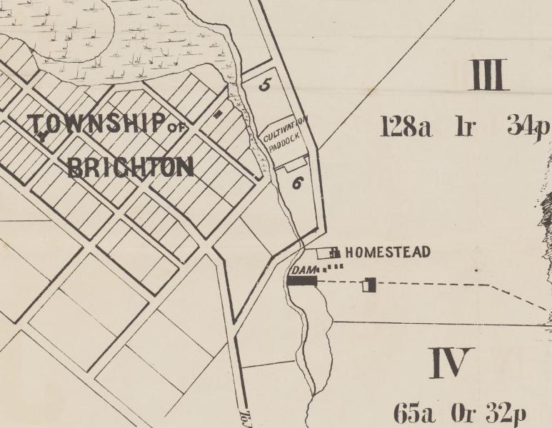
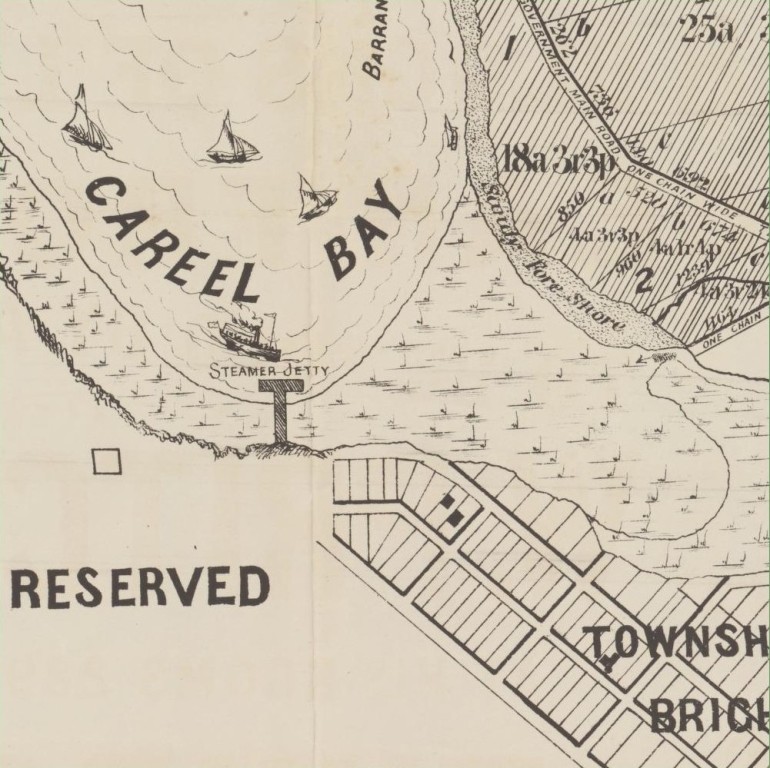
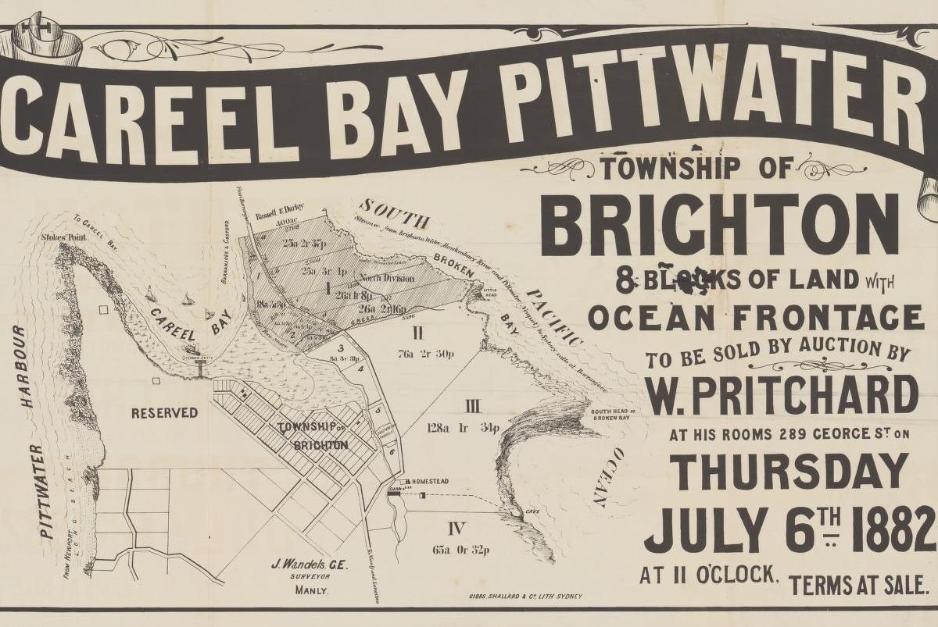
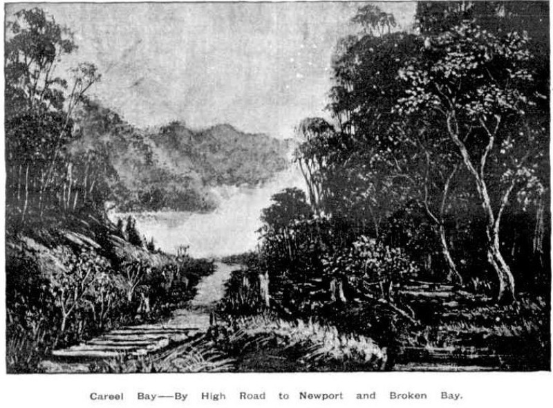
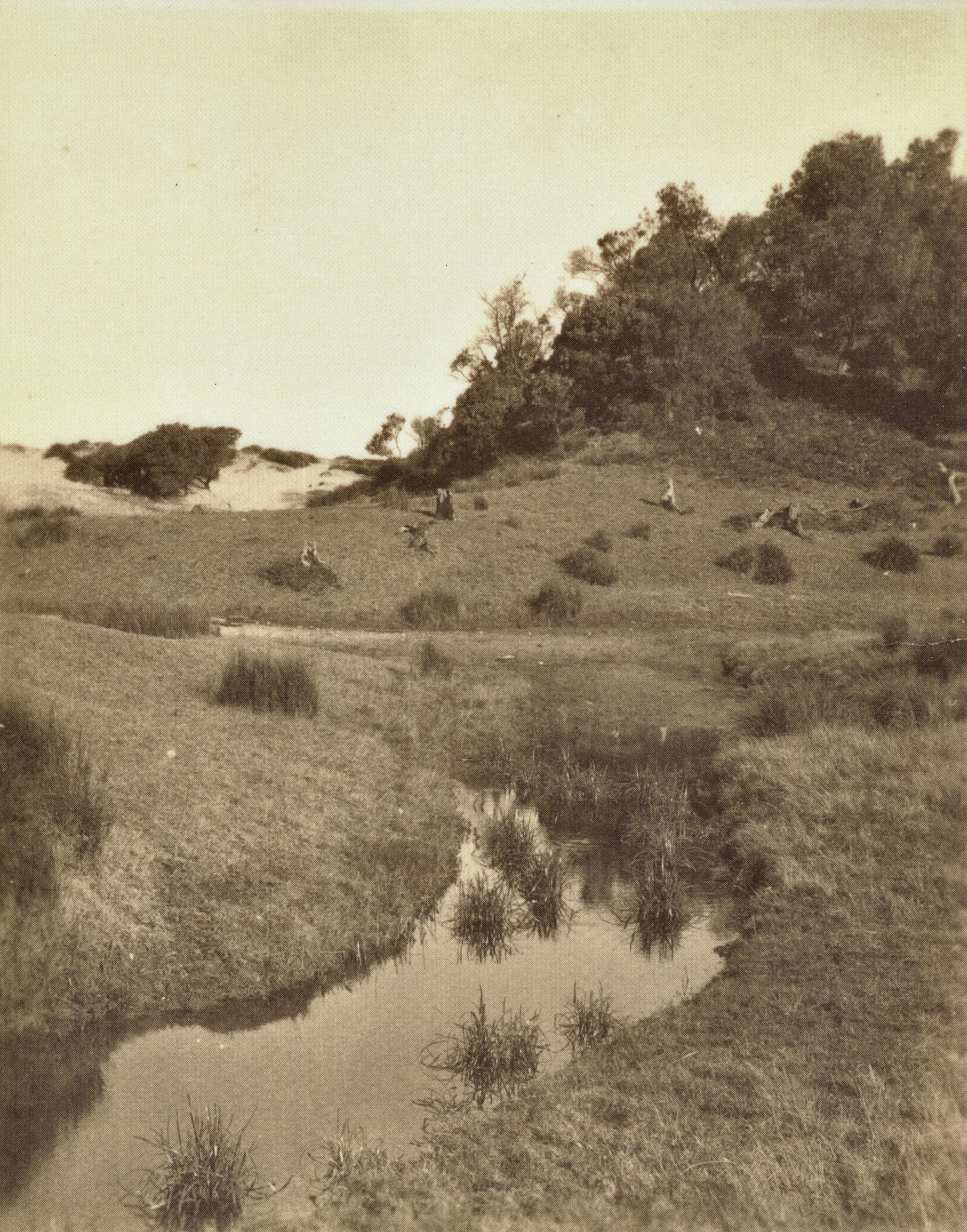
Section from: Careel Bay Pittwater [cartographic material] : township of Brighton, 8 blocks of land with ocean frontage - 1882. MAP Folder 135, LFSP 2160. Courtesy National Library of Australia. Note the placement of the dam and the expanse of mangrove flats marked at the top left of the lithograph leading into Careel Bay
Further north another creek allowed for another dairy 100 years on where fresh water flowed from the north end of what we today call Bangalley Reserve, down through Careel Head road, into Albert and Burrawong roads, and thence once again into the northern end of Careel Creek and Careel Bay. See: Careel Head Road Shops and the Bangalley- Burrowong Creeks: Some History
At the north end of Avalon Beach at least 2 creeks would flow to fill up the current space known as Des Creagh Reserve, one from near the top of Marine Parade, one from the southern corner of Bangalley headland.
In his 1861 published 'My Holiday' Charles de Boos describes the valley of Avalon, and to the edge of the Collins place at Catalina Crescent, and to Careel Bay and Snapperman Beach, Palm Beach, from the point of climbing out of Bilgola Beach (no Bilgola Bends road as yet), as:
Following the road, we mounted and crossed the range which terminates in the bluff headland, at the base of which I had been so completely drenched on the proceeding day, and then followed a gradually descending track which wound round the hill side into a deep indentation of the land, until it came down to the level of the sandy ridges which bordered the beach, and then dived into a thickly wooded dell, which though so close to the borders of the seam was one tangled mass of vegetation. It was in fact the embouchure of a long gulley, that, separating two extensive and lofty spurs from the main range was so far sheltered by each from the cutting breezes of ocean, as to allow of the growth of every description of plant in we same profusion as in the gullies I have previously described. Through the midst of it ran a tolerably broad sheet of water, the ordinary brooklet of clear, bright, and sparkling water having been transformed by the late rains into a miniature torrent, turgid and bellowing and carrying down before it small boughs and debris from the hills above, in humble imitation of larger streams. By the aid of a fallen tree we managed to cross the stream dry footed, but it was only by breaking down and walking over the branches of the bangolas and by taking advantage of such tufts of grass or such dead timber as offered that we could manage to cross the centre of the gully which the brook had covered with a mimic inundation.
Once through this jungle of a gully, and we had a gently rising road, creeping steadily up the face of the range, by easy graduation until at last it had gained the crest. Then we had a monotonous walk along the top of the ridge, in full view of the vast Pacific to our right, whose waves were now beating almost lazily along the beach at our feet and whose waters had barely swell enough on them to keel over the tiny fleet of coasters that had put out from different ports of shelter on the coast with the first slant of the favouring wind, and were now lying almost motionless, with scarce wind enough to lift their sails. To the left, the hills, covered with the low close scrub common to our coast ranges, bounded our view, the inland ridges, with their heavily timbered sides being hidden from our sight. Suddenly, however, the road took a curve round to the left, crossed a knoll of the range, and then swept down, in some fifty different tracks, on to a broad swampy plain, or flat, which seemed to us to be inundated, for we could see the water sparkling and glistening in the sun over its whole face. I pulled up short here.
" It won't do to go down there, Tom," said I.
"Oh, but we must," he replied. "This is the Priest's Flat, and there, where you see those shears erected, with the two tents alongside of them, is where they are boring for coal. We must go and report progress."
I looked ruefully at Nat, who made no reply, but, grinning viciously, bent down and turned up his trousers to the knees.
“Do you think there are any leeches there ?” I asked. Nat's trousers were instantly turned down again, and this time he didn't grin,
"Oh, no," Tom answered, "there's too much water there for them, and not enough shelter.
I was easier in my mind, though I had my misgivings; but as these Antipodean leeches seemed to be ruled by laws, and to have amongst themselves habits and customs totally at variance with those of leeches in civilised communities, possibly Tom might be correct; so, tucking up my trousers, I prepared to descend. And, after all, when we got down to the flat it was not so bad as it had appeared to us from the hill. The ground was somewhat honeycombed and the water lay in pools, between which however, we managed to find sufficient footing without actually walking in water.
Arrived at the tents, warning of our approach was given by a solitary dejected bark, ending in a melancholy and prolonged howl, from some unseen dog, that was evidently too broken down and low-spirited to repeat the challenge and it was only after we had approached the shears, and had commenced our examination of the boring, which, to tell truth, none of us could make head or tail of, that a tall sailor looking man, who appeared as if he had but just that instant been uncoiled full-rigged from between the blankets, came out to the entrance of one of the tents, and regarded us with an air of blank and sleepy astonishment. Just after him followed his watchful canine guardian, whose short bark and long ululation had effected his master's awakening, but so far behind as not to be within kicking distance; his cowering watchful look, and his tail hard down between his legs, evidently saying as plain as could be said, " I don't know whether I have done right, so I must stand by for squalls."
It took a good deal to waken up our friend to a full sense of the information we required from him, and it was only by the casual mention of Farrell's name that he was brought to his full mental perceptions. A grin spread over his countenance when we said where we had just come from.
“Did you go candling with him ?" he asked. We explained how it was that we had not done so.'
“Oh, isn't it prime fun !" He was fast getting lively.
He had been of the party the night before our arrival, had got wet through, had disported himself like a grampus in the pool, and had got home with an exulted notion of the sport. Of course we did not undeceive him; but having now got him up to the proper communicative pitch, we proceeded to worm out of him, by dint of much questioning, and much labour in bringing him back to the subject in hand for he would insist upon darting off from it at a tangent to give us collateral evidence upon matters in which we had not the slightest interest-all that he knew of the boring.
From the information thus acquired, as well as from enquiries subsequently made, I learnt that the spot now being bored was about the centre of a very fine property of some 1200 acres in area, granted many years ago to the Rev. Father Therry, and extending across the Barranjuee peninsula from the shores of the Atlantic to those of Creel Bay; the one being its eastern, the other its western boundary. Hence the plain had been christened the Priest's Flat. It had been for some time surmised, taking into account the dip of the coal basin, which crops up to the north at Newcastle, and to the south at Wollongong, that at this spot, which lies so near the northern cropping point, the coal seam might be struck at such a medium depth as would allow of payable working. Somewhere about twelve months ago, the reverend proprietor determined upon trying the experiment, and he has continued perseveringly at the work in spite of every discouragement that has beset him; and certainly he has had in this matter to bear up against contrarieties sufficient to have wearied out the majority of ordinary persons.
At no time have the men employed ever injured themselves by hard work, for the testimony of the natives goes to show that they hung it on most amazingly, and when obliged to do something for their money, rather than sink deeper they would break the auger. On another, occasion, an overseer that was employed bolted with the month's pay of the men, and, not satisfied with that, took also the reverend father's horse, though this was subsequently recovered, but only after paying a pretty Bullish sum for stabling expenses. Just as we visited the spot the 'works were again at a stand-still by the breakage of the apparatus, and the newly-appointed overseer was away in Sydney getting it repaired, whilst the hands were scattered hither and thither. They had at that time got to a depth of 186 feet, but had come upon no indications of coal, if we except the passage of the auger through a 6-inch pipe of coal at a depth of 123 feet. (Since these articles were commenced, I have learnt that the boring has reached a depth of 220 feet), when the work was suddenly brought to a close by the breaking of the auger, and, what was worse, by the cutting portion of it being left firmly embedded in the rock that was then being pierced.
Whilst upon this subject, it may-not be out of place to mention that I visited, though somewhat subsequently to the time now alluded to, the bluff headland almost in an easterly line with the boring, and named by the reverend proprietor St. Michael's Head; and there, at about eight feet above high water mark, and quite open to view, is a thin seam, or, as miners term it, pipe of coal, scarcely an inch in thickness. On examination I found also that very much of the shale, both above and below the seam, bore carboniferous indications-leaves, ferns, &c, being distinctly traceable on the face of the cleavages. Another great discouragement that must have operated very strongly upon the rev. owner has been the expense that the work has entailed on him, in consequence of the bungling inexperience and roguery of the persons who have, until lately, been entrusted with it. On this point I speak only on hearsay, and my information is consequently liable to correction ; but I was told with an air of authority that the cost of sinking had, up to that time, reached very nearly £800, being at the rate of rather more than £4 per foot, whilst the time occupied in sinking had been over nine months, or about twenty feet per month not a foot per diem ! If this was not enough to put an extinguisher upon ordinary enterprise, I can't conceive anything that would be. Under the present management I am informed that the work promises to progress more favourably.
We were not very long in pumping perfectly dry the maritime-looking individual who had charge of the works pro tem ; and, by the way, I would here ask how it is that nearly all the males we have encountered in our tracks have so decidedly nautical an appearance? Can it be that, like the islands in the Pacific have been said to have been, this particular portion of the territory of New South Wales has been peopled by the sole survivors of awful wrecks, by men supposed by anxious friends to have been drowned years ago, and who now turn up mysteriously in this unknown land? or, are the inhabitants of the Peninsula like the Arabs on the African coast, and do they seize and treat as slaves the shipwrecked mariners that are cast amongst them by the Pacific, in its un-pacific moods? or have they fled to these wilds to escape the too fond and anxious enquiries, through the water police, of disappointed shipmasters or deluded agents ? The question is one that perhaps some future Australian physiologist may be tempted to solve.
We parted with our friend with but scant ceremony, he turning on his heel and walking into his tent when we told him, "that was all;" whilst we shouldered our loads and walked ahead. Pushing along the edge of the flat, we crossed the foot of the hill we had not long previously descended, and, passing along an inner one of well-grassed sandbanks, that formed the landmost barrier against any encroachment of the waves, we came after a walk of half a mile to a paddock fence, through a slip panel of which the road evidently ran. Entering the paddock we found the upper part overgrown with young timber, principally wattles, that had sprang up since the cultivation of the toil had been discontinued, whilst about half-way across it we encountered a beautiful stream of running water, bright and clear as crystal, and crossed by a very rustic, and at the same time, very dilapidated-looking bridge. Nat was in the van at the moment, and I was astonished to see him, when he reached the brook, throw down his load and descend the bank to the water. Arrived there, he began hastily selecting some of the darkest leaves of a plant which I now observed grew very thickly on the margin of, and even in the water.
"What's the row ?" said I.
" Watercresses," replied he. "Stunning!"
" I'm there," cried Tom; whilst I made no answer, but slipped my shoulders out of my load, and commenced an attack upon this favourite pungent water plant. We amused ourselves for some five minutes over them, and then, filling our billy with the choicest stems we could find, once more made tracks.
After crossing the creek, we came in sight of a homestead, small but neat, having evidently been only recently whitewashed. The paddock was now clear of all undergrowth, and, as a goodly cluster of large trees, the remnants of the former occupants of the soil, had been left standing round the house, it had an exceedingly pretty and picturesque appearance, its white sides gleaming out markedly from amongst the bright green of the shrubs around it, and the dark and sombre verdure of the forest monarchs that overshadowed it.
"This," said Tom, "is Tom Collins, and he's the man that will show us the cave."
“The cave ?" asked I. "What cave ?".
" You'll see," he answered, "a rum 'un; such a one as you won't find anywhere else within a day's ride of Sydney, I can tell you."
Here was a surprise indeed. I had never, during the whole of my lengthened sojourn in Sydney, heard of this cave, and I don't believe that fifty persons in the metropolis are to this day cognisant of its existence; thus, with a feeling something near akin to that of a first discoverer, I hastened up to Collins domicile.
(To be continued.)
MY HOLIDAY. (1861, August 26). The Sydney Morning Herald (NSW : 1842 - 1954), p. 3. Retrieved from http://nla.gov.au/nla.news-article13059581
MY HOLIDAY
[CONTINUED.]
(From the Sydney Mail, August 31.)
A tap at the door brought out the mistress of the house, accompanied by her brood of little ones, all fat, chubby, and rosy faced, bearing on their countenances the imprimatur of good health. Having mentioned our errand, we were invited to enter, and we found the interior of the domicile even more neat, and white, and bright, than the exterior, for it was the very beau ideal of cleanliness, and care. The tin-ware which hung from the shelves was polished till it shone like silver, whilst the shelves themselves being of deal, were scoured almost to whiteness. The floor, though an earthern one, was swept so clean that it more resembled a single large slab of stone than what it really was; and the fire in the huge bush fireplace was nicely kept in the centre, each side being swept as carefully as the floor itself had been. The hut had been recently whitewashed throughout, and the whole had such a light and cleanly air as strongly to remind me of some of the farmhouses it has been my lot to visit in the mother country, where, perchance, some notable housewife would take such a pride in polishing that even to the iron hoops of the churn, the piggins or the milk coolers would be burnished up till they resembled steel.
Unfortunately our man, Tom Collins, who knew all about the cave, and who was, in fact, its first discoverer, was absent from home; his brother, however, would very willingly guide us to the spot, so said Mrs. Collins, and waiting the arrival of her brother-in-law, she brought forth a huge jug of milk, from which she desired us to help ourselves; and if Tom and Nat didn't do so to a pretty considerable extent, they made a very good attempt at it, that's all. I verily believe that they would have had impudence enough to have asked for another quart, had not the arrival of Collins frer turned their attention to another quarter. He at once expressed his willingness to conduct us, and furnished himself with a piece of candle, the interior part of the cave being so dark as to require a light for guidance amongst the fallen rocks that encumber it.
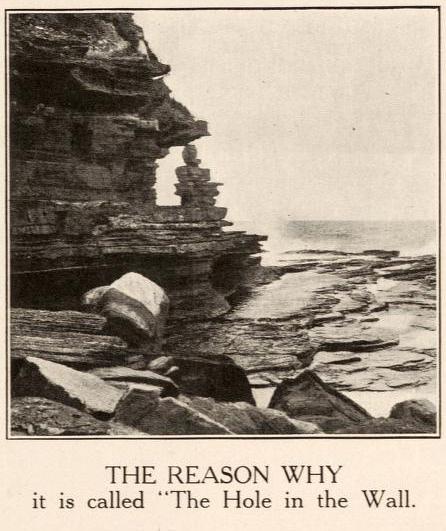
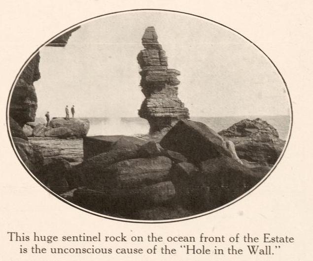
He led us off in a straight line from the front of the house to the sea, to a spot where the high wall of rock which is here presented to the waves sinks rather slightly, and a little to the north of the well-known rock, "The Hole in the Wall." Bringing us to the edge of the cliff, he pointed to a bit of a track, down which there had evidently been some slipping and shuffling. This went down for about five feet, and then we could see no more. All beyond that appeared to us, from where we stood, to be blank space; and I had a kind of faint idea that, like Farrell's candleing, this was some more of the peninsularies' fun, and that they let themselves slip down here, shot out into space, and chanced the rest. Tom looked at the track and turned pale. Nat inspected it, and turned up the bottoms of his trousers, a sure sign with him of determination, and about equivalent to the turning up of the coat cuffs by the school boy when he has made up his mind to dare some bigger boy to combat. I have already said what my feelings were, but in the position I occupied, as leader and originator of the expedition, it was necessary that I should set an example of decision, if not of courage. There was a small ledge or platform about three feet down on which the whole four of us could have stood easily ; so down on to this I leaped, with something of the same kind of feeling as Marcus Curtius must have had when he took his leap that everybody has heard so much about. Nat followed very readily, but Tom still hung fire.
"It's only just a little bit that's awkward," said Collins, "after that there's as good walking as there is up above."
But Tom was not to be tempted, and that "little bit" struck terror even to my heart, though I was determined upon prosecuting my discovery to the utmost. From the ledge on which we stood, we could only see just two or three feet' of downright slippery descent, and beyond that nothing but the black rocks two hundred feet below, and the crested waves breaking on them in white foam.
"Follow me," said Collins, as griping a projecting point of rock, he slid down the track, dislodging the stones and pebbles, and sending them rattling down upon the rocks below in a regular shower. In another second he had disappeared, and I heard no smash, no cry of torture, so taking heart of grace, I laid hold of the point of rock - oh, if I didn't hold it tight - slipped down the path, shot round a corner, almost breaking my spine with the twist, found my feet laid hold of by somebody, who placed them firmly upon a stone, and then, looking round, perceived that the worst was really over, and that now there was a good plain track running down to the rocks.
My admiration, however, was somewhat marred by a pair of thick boots which, cocking rapidly down from above, struck me somewhat rudely over the head, and as Nat's feet happened to be in them, and, as wanting the guiding hands that had placed me on the friendly rock, they were thrown wildly about, the blows were rather more than I had calculated upon. Nat soon got his footing, and then began to abuse me for getting in his way instead of apologising for his carelessness. We now shouted to Tom that we were all right and bade him follow. As he saw that the thing was done so easily, he hardly liked to jib, so he sang out to us to wait for him, as he was coming. We looked upwards for him with some anxiety, and in the course of a couple of minutes we had a full view of "the boots." They and they alone stopped in sight for a full minute, and we began to fear that Tom had caught somewhere, when suddenly down came the boots and Tom too, all in a lump, sliding down on the hunkers' after the same fashion as I have seen children slither down a slanting board. He had taken the notion that if instead of griping the cliff as we had done, he stooped down in the way I have described he could guide and check his progress with hands and feet. Here he made a woeful mistake, for the breaks in the descent were too heavy, and poor Tom came jumping down kangaroo fashion, bumping and thumping against the rocks, and so completely done up, that if Collins hadn't caught hold of him, he would certainly have gone bumping and thumping to the bottom.
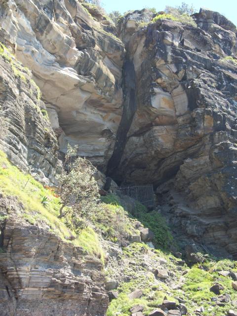
We now descended to the rocks by a comparatively easy path, and passing along to the southward of the point whence we had started, we followed the rocks round a small projecting headland, on the south eastern face of which the cave is situated.
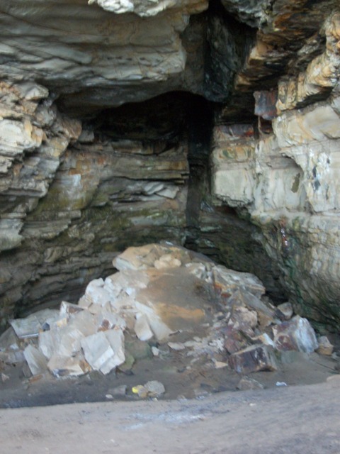
It is about eighty feet above high water mark, and about twice that distance from the summit of the headland. When we had mounted to it, and stood at its entrance, we found that a kind of bank or platform had been formed in front of it, covered with coarse grass and with an extensive growth of wild parsley, that seemed to flourish here in great luxuriance. The entrance forms a kind of rude irregular gothic arch, about twenty or five-and-twenty feet high in the centre, - the interior of the cave, that is, its first compartment, being about twice that height, in consequence rather of the descent of the flooring of the cavern than of the rising of its roof. It has evidently at some former period been considerably deeper than it now is, as vast masses of rock that have fallen from the roof above lay strewn about, and heaped upon each other, particularly in the centre, to be gradually, but surely, covered by the fine sand that drifts in with every southerly breeze through the entrance, and also by the guano, if such it may be termed, deposited here by the myriads of bats that make this cavern their home. The first thing that strikes the visitor on entering is a long flaw or rent in the sandstone which is here the prevailing rock. This flaw runs along the centre of the whole length of the roof of the cavern, being about three feet in width, and in a perpendicular position, and is filled up with a highly ferruginous sandstone, sounding particularly hard and metallic when struck.
At about eighty feet from the mouth, the floor is covered with immense boulders of stone that have fallen from the roof of the cavern, and almost block up the way to the second compartment. A great part of these has fallen during the bad weather of the last year or two, a continuous rain, followed by a thunderstorm, being sure to bring down some one or more of the huge projecting masses that bulge out from the roof, and threaten to fall at the smallest provocation. Passing round this heap of debris, we now light our candle, for the mass of wreck so far shuts out the light of day as to render artificial light necessary. We now find ourselves in what may he termed the second compartment, which has a more regularly arched and compact appearance than the first, though it is somewhat smaller, being about twenty feet in height and the same width across, whilst the first is at least forty feet high and as many feet in width. Here we can more clearly perceive the ferruginous character of the interloping seam or flaw that has doubtless been the primary cause of this peculiar formation. The drippings from this perpendicular inset between the native rocks hang down in long rust-coloured pendants of oxide of iron, whilst the rocks on either side are formed in regular horizontal layers, the edges of the different strata, and in fact every protruding point of this part of the cave being covered with a white efflorescence from the phosphate of lime that has gathered on them ; whilst here and there other emanations from the rocks have settled in small chrystals upon its face, and reflect back the rays of the candle in all the gorgeous colours of the prism.
This compartment is the favourite resort of the bats and birds, the lighting of the candle creating a regular commotion amongst the denizens of the place. That they have occupied it for many long years possibly for centuries, is probable from the fact that in rooting among the sand and guano that cover the floor to an unknown depth, Collins informed me that he had met with large masses of an ammoniacal salt, that it must have taken the simple laboratory of nature very many years to bring to the state in which it is found.
Somewhere about ninety feet from the heap which I take as forming the boundary between the first and second compartment the cavern narrows very considerably, and we enter by a passage about wide enough to admit four persons abreast into the last chamber of this extraordinary place. As the sides come closer together, so also does the roof descend, and a tall man would here be able, by a good stretch of his arms, to touch the top; and so it runs in for another twenty or thirty feet, sides and top gradually collapsing, until at last there is but the width of the flaw, and scarcely height sufficient for a man to sit down. Here the iron percolations prevail, as in the second compartment those of the lime are most abundant ; and we strike against the interjected seam, and, by dint of much labour and perseverance, chip off from it a piece of rock which has all the appearance of being actually iron in a rude state of preparation. We also see portions of it lying in long seams upon the sandstone rock it has divided, and which appear burnt and charred as though it had been subjected to powerful electric action. We also look back now to the way by which we have entered, and just over the heap of rubbish and natural ruins that impede our sight, we mark the bright light of day, which, from the distance we are placed at, is chastened and subdued almost to a twilight. Everything seems solemn and suppressed; all outward sound is shut out, and there is not even a drip from the roof above to break the pervading stillness. We speak in our ordinary tone, but our voices, crushed down by the massiveness around, sound as if we were conversing in whispers. We are in no grand echoing hall, the work of mans' hands that sycophantly sends back the compliments that are given to his skill. We see before us the work of the Great Architect of the Universe, who labours not by the hand, but employs the meanest and the humblest instruments to do His bidding, and who, with the drop of water or the grain of sand, hollows out mighty caverns, or builds up giant mountains. .....We journeyed for some distance round amongst the vast heaps of rocks, on which the waves were breaking lazily though unceasingly, until we had reached St. Michael's Head, where the narrow seam of coal, alluded to in my last, was shown to me, together with the strata of carboniferous shale lying above and below it.
When we had seen all that was to be seen here-abouts, we retraced our steps, the point at which we had descended being the only one by which an ascent could be effected ; and no sooner were we on the back track than we missed Tom. Enquiries were mutually made, and then it was remembered that none of us had seen him since leaving the cavern. I was uneasy. I was fearful that he had fallen down some of the immense crevices that yawned between the vast masses of stone that we had had to traverse on our way; and on our retreat I peered down these as I passed them with a kind of nervous dread on each occasion that I should see his crushed and mangled body lying inanimate at the bottom. We didn't find him in any of these, but just as we were mounting the track up to the first slippery point of descent, we heard Spanker's bark, and looking in that direction saw Tom stalking along the rocks half a mile away, looking for the pathway that he had passed.
A cooey from us showed him his mistake and he was not long in rejoining us, whilst Spanker was so elated that he made a spring up the ascending path in the exuberance of his spirits, but happening to jump rather short, and not being gifted with hands to secure a hold, he came rolling back amongst us, and nearly sent us toppling off the narrow pathway, which we were mounting in Indian file, something after the manner in which children knock down the long files of suppositious soldiers represented by bent cards. By dint of some little muscular exertion, and some pushing and pulling at each other, the ascent was successfully accomplished, and we once more stood upon terra firma, for the vast boulders of rock over which our way had been made was certainly not entitled to that designation. Tom was so elated at finding himself once more safe and sound from an adventure over which, from the very first, as he afterwards confessed, he had had the most painful misgivings, that he fired at and killed the first bird that came across him, the victim in this instance being an unfortunate gill-mocker, who had attracted Tom's attention by several times telling him to "Go back," a piece of advice that, in Tom's then state of mind, must have savoured strongly of sarcasm.
Having thanked Collins for his kindness and attention, we once more pushed ahead, the road now leading us across a long level piece of country that intervened between the sea and the waters of Creel Bay, until it brought us down to the margin of the latter. Arrived here, we had before us as pretty a marine picture as ever painter sketched, and as directly opposite to the one we had but so recently left as could be well conceived. The flat level land had here narrowed to some sixty rods in width, being backed by a heavily wooded range, the base of which was here and there encumbered by large masses of rock, from which the incumbent soil had been washed, and which now protruded in huge boulders, or lay out bare and detached from their native beds. On the margin of the bay were three little whitewashed slab huts with bark roofs, the passionate squalling of an infant that proceeded from one of them would have given evidence of their being inhabited, even if we had not seen two or three barelegged and barefooted children peering at us round the corner of the house.
Through the narrow belt of low swamp oaks that edged the margin of the bay, the clear smooth waters of Creel glistened in the sun, as the gentle breeze swept over its face and slightly ruffled its surface. On the sands, midway between the shore and the retreating water, for it was nearly low tide, two boys were busied collecting shells, by filling an old basket with the sand, and then agitating it in a water-hole, made for the purpose, until the sand was washed away, and nothing was left but the shells that had been mingled with it. These, when washed clean, were thrown into a boat that lay down helplessly on its side close to them. Out on the waters of the bay, floated a smart little cutter, which, though probably only a shell boat, looked from the clear atmosphere, and perhaps also from the fact that she was the only vessel in view, smart and dapper as a yacht, the red shirt and striped cap of the one man on board, adding still farther to the picturesque appearance of the vessel. Behind her again stretched out the waters of the bay, until they encountered the ranges of the other side, which coming down in many a ridge and gully, and forming many a deep indentation or projecting point, gave a gorgeous variety of tints and lights to a background that under a less brilliant sun or less pure atmosphere would have been sombre and monotonous.
Manly to Broken Bay. (1893, November 11). Australian Town and Country Journal (NSW : 1870 - 1907), p. 19. Retrieved from http://nla.gov.au/nla.news-article71191632
We halted here just long enough to admire the scene, and to have a shot at one of a number of blue cranes, that were stalking about most consequentially and at the same time most warily upon the sands. It was only by dint of a good deal of manoeuvring and dodging that Nat was enabled to get even within possible shooting distance of the rearmost of the lot; and after all, when he fired, he didn't kill his bird. He however succeeded in frightening it, and not only it but all its companions, for they one and all took to flight with a wild cry. But if he had in one quarter caused a fright and a cry he had in another caused a fright and quietness for the report of the gun had stilled the squalling in the hut so effectually that it was not resumed, so long at least as we remained within hearing.
The track, a mere bridle path, now led along the flat, then across a dank luxuriant gully, down which a little stream roared and brattled and foamed with as much fuss and bother as would have been sufficient for a volume of water twenty times its quantity; afterwards, up a wet sloppy hill from which the water exuded in every direction, round the point of the range, down a correspondingly wet and sloppy descent on the other side; and then on to another flat the very counterpart of the one we had just quitted. Another luxuriant and overgrown gully, another wet hill teeming with springs, and then we come down, upon a somewhat broader flat, at the extremity of which we see two tents a short distance apart that we at once recognise, from the description we had received of them, as being the Chinamen's place.
(To be continued.)
MY HOLIDAY. (1861, September 2). The Sydney Morning Herald (NSW : 1842 - 1954), p. 3. Retrieved from http://nla.gov.au/nla.news-article13057913
When Therry passed away his 1200 acre estate in the valley of what is today's 'north Avalon Beach' was sold in large portions as the 'North Division' of the estate.
On May 3rd 1880, Richardson and Wrench offered the Therry estate, as they did again the following year, stating in the listing that there were 'well-known springs' on Areas 3 and 4 which were north Avalon Beach, with access to Careel Bay wharf, should the track that was a road of sorts prove too muddy to be passable:
PITTWATER and CAREEL COVE.
The whole of the residue of
THE PITTWATER ESTATE.
Also,
STOKES POINT, which is now subdivided into VILLA SITES, fronting CAREEL COVE
and PITTWATER.
adjoining the Township of BRIGHTON, PITTWATER.
RICHARDSON and WRENCH have received instructions to sell by public auction, at the Rooms, Pitt-street, on MONDAY, 16th May, at 11 o'clock, The whole of the unsold lots of
THE PITTWATER ESTATE, as follows :
NORTH DIVISION.
TWO CHOICE FARMS.
No. III. Area. 128 ACRES 1 ROOD .14 PERCHES, having frontages to the PACIFIC OCEAN and the MAIN ROAD to BARRENJOEY, on which is the HOMESTEAD and, RESIDENCE now in the occupation of JOHN COLLINS, Esq.. and also the CELEBRATED CAVE.
No. IV. Area, 65 ACRES and 32 PRRCHES, adjoining the above, and which are the WELL-KNOWN SPRINGS....
STOKES' POINT, PITTWATER.
ADJOINING THE TOWN OF BRIGHTON, AT THE STEAMERS WHARF.
The whole of this Magnificent Point will be submitted in lots, as per lithograph, now published, viz..
Section A. 15 VILLA SITES; areas. 3 ROODS 17 PERCHES to 2 ACRES 20 PERCHES.
Section B. 14 VILLA SITES : areas. 1 ACRE 10 PERCHES to 6 ACRES 3 ROODS 32 PERCHES
Section C. 9 VILLA SITES. CAREEL BAY ; areas. 1 ACRE 3 ROODS 34 PERCHER to 4 ACRES 21, PERCHES
Section D. WATER FRONTAGE SITES; areas. 2 ACRES to 4 ACRES 21 PERCHFS. PITTWATER HARBOUR
Section E. 10 VILLA SITES, adjoining the TOWN OF BRIGHTON : areas. 1 ACRE 11 PERCHES to 4 ACRES 1 ROOD 23 PERCHES.
This subdivision is well worthy of attention, as there is no doubt that PITTWATER will become an important and attractive resort for our BUSINESS MEN requiring CHANGE OF AIR, QUIET, and REST from the busy turmoil of the city.
The communication between the city and Pittwater is now more frequent than formerly, besides having the coaches daily from MANLY BEACH, there are now commodious fast steamers plying regularly from the city.
The NORTHERN RAILWAY will pass within 7 miles of CAREEL COVE at Pittwater.
TERMS EXCEEDINGLY LIBERAL AT SALE.
LITHOGRAPHS are now READY FOR DISTRIBUTION.
Messrs. ELLIS and MAKINSON, Elizabeth-street, are Solicitors of the vendors. Day of Sale, MONDAY NEXT. Advertising (1881, May 12). The Sydney Morning Herald (NSW : 1842 - 1954), p. 9. Retrieved from http://nla.gov.au/nla.news-article13479502
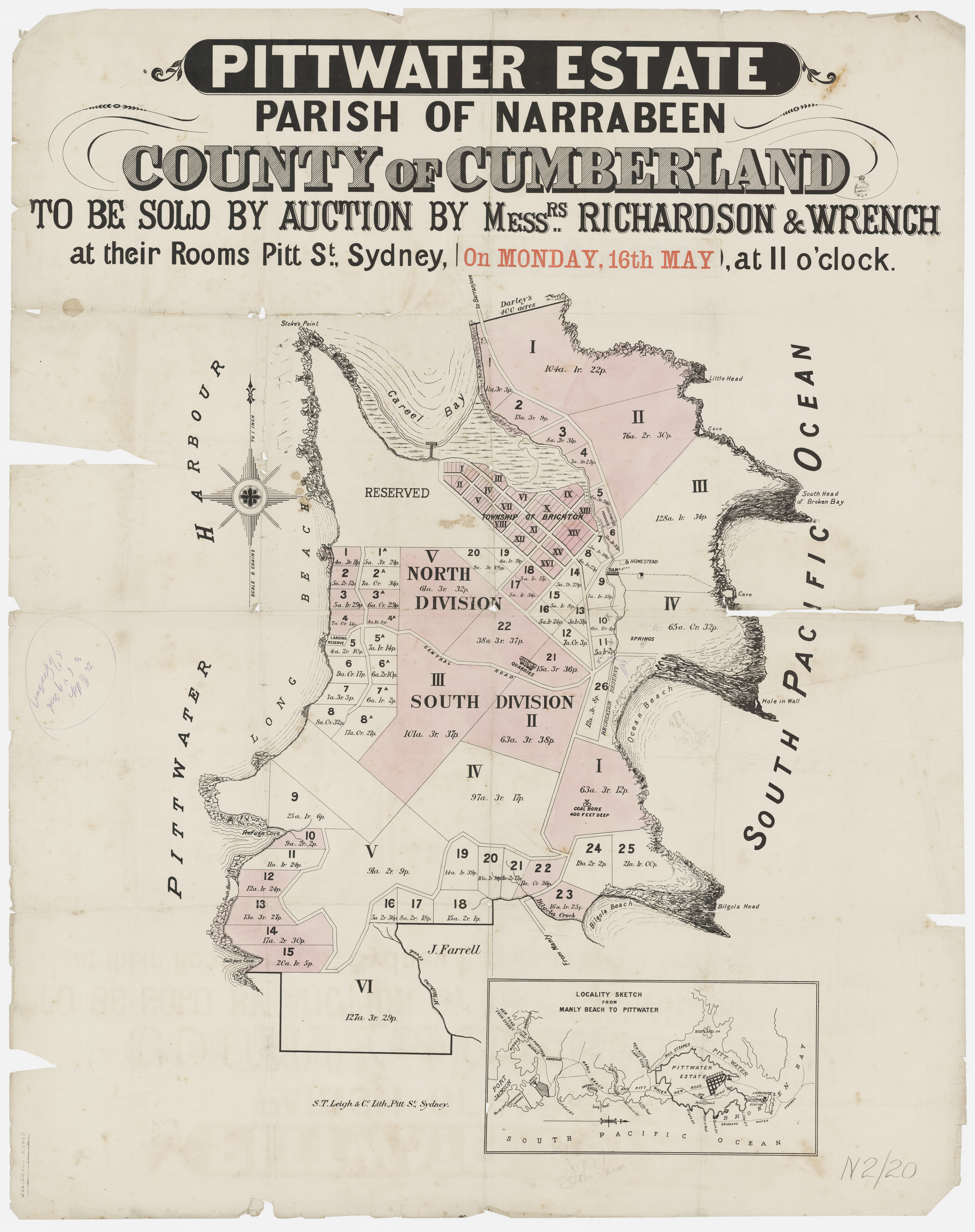
Pittwater Estate Monday May 16th, 1881 - Richardson and Wrench - Item c050370020, courtesy State Library of New South Wales.
As time went on these large portions changed hands and were brought under the Real Property Act.
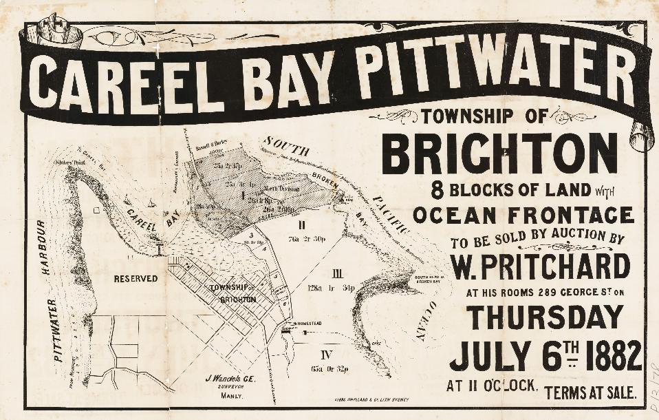
Careel Bay Pittwater - No boundaries shown, 1882. Item No: c053460084, courtesy State Library of NSW.
Primary Application 18259 records Harley Usill Mackenzie & John George Cousins are applying to bring land 'situated on the road from Manly to Barrenjoey & Careel Creek at the South Head of Broken Bay & Hole-in-Wall on the South Pacific Ocean' in the Shire of Warringah, Parish of Narrabeen, and recorded in Volume 2560 Folio 190, under the Real Property Act. Dates in NSW Records and Archives are: 12-11-1912 to 16-03-1915.
Primary Application 18259 records 128 acres, 1 rood 34 perches for Lot 3 and 65 acres 32 perchesxz for Lot 4.
Primary Application 18259:
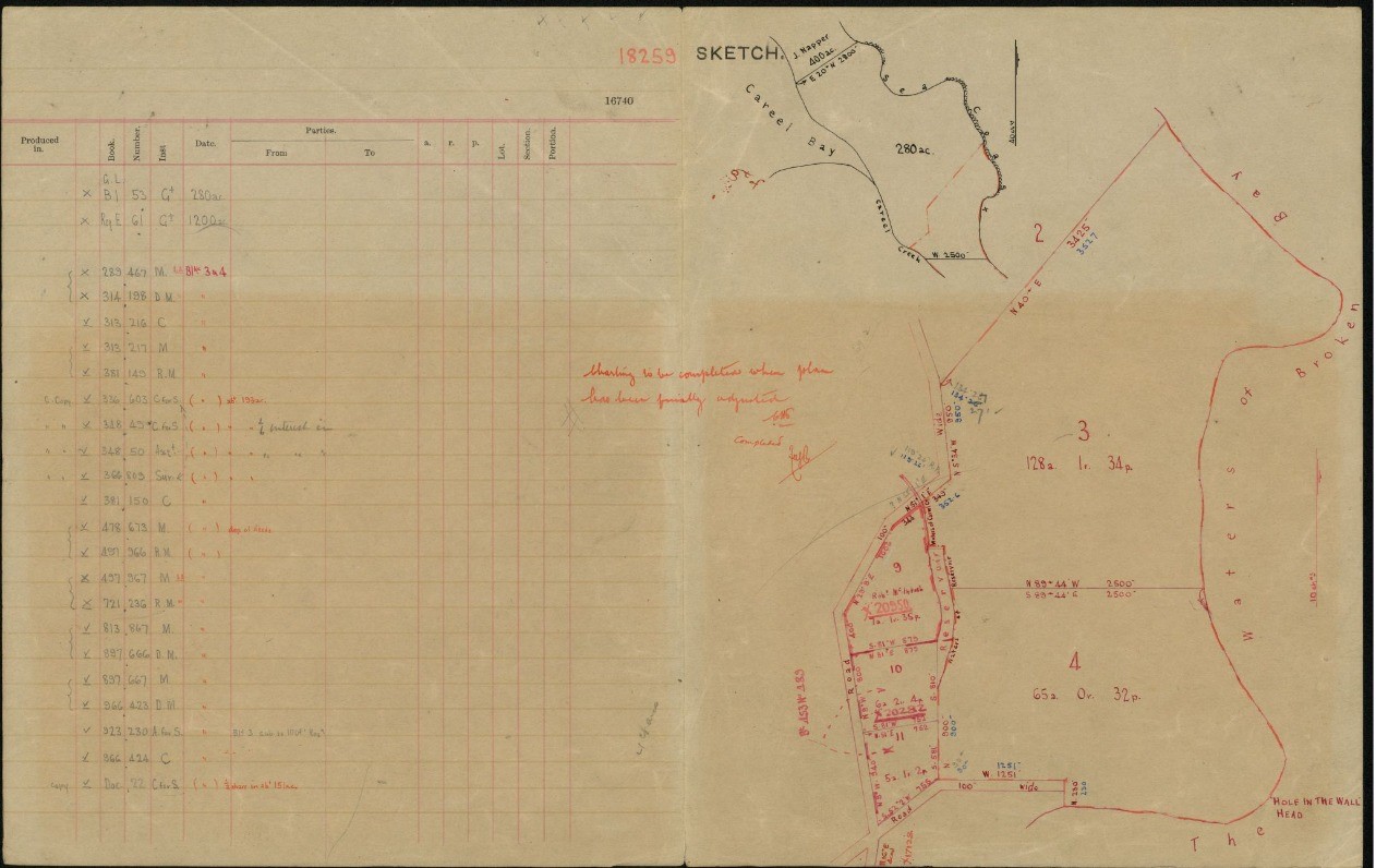
No. 18,259. APPLICANTS:—Harley Usill Mackenzie and John George Cousins, both of Sydney. LAND:—County Cumberland, parish Narrabeen, shire Warringah, 161 acres 1 rood 16 perches, on road from Manly to Barren joey and Careel Creek, at South Head of Broken Bay and Hole-in-Wall on South Pacific Ocean,—lots 3 and 4, North Division, Pittwater Estate, also part 280 acres (portion 49, parish), and 1,200 acres (portion 20, parish), granted to Reverend John Joseph Therry; adjoining properties of H. R. Nolan, E. Darvall, F. M. Callaghan, estate late J. Lucas, Warringah Shire Council, and applicants. NOTICE UNDER REAL PROPERTY ACT. (1914, December 16). Government Gazette of the State of New South Wales (Sydney, NSW : 1901 - 2001), p. 7405. Retrieved from http://nla.gov.au/nla.news-article227425339
Harley Usill Mackenzie, 'Solicitor' of Sydney was the eldest of five sons of Walter and Frances Mackenzie (nee Usill). John George Cousins, 'Warehouseman' of Sydney, had a long association with the area and possibly met Harley when he was being defended by his firm, as instructed by Harley in 1908, for fraud. John Cousins married a Mary Roberts in 1871. Between 1884 and 1890 Mr. Cousins is in Manly running 'Cousin's Steyne Hotel':
In the Supreme Court of New South Wales.
ECCLESIASTICAL JURISDICTION.
In the goods of Alfred Cousins, late of Manly, in the Colony of New South Wales, mercantile clerk, deceased, intestate.
NOTICE is hereby given that after the expiration of fourteen days from the publication hereof, application will be made to the Supreme Court of New South Wales, in its Ecclesiastical Jurisdiction, that letters of administration of the estate and effects of the abovenamed Alfred Cousins, who died at Manly aforesaid, on the 1st day of December, 1884, may be granted to John George Cousins, of Manly aforesaid, hotel-keeper, the father and next of kin of the deceased.—Dated this 24th day of November, 1885.
LOUIS FREDERICK DIXON, Proctor for the Applicant, 92, Pitt-street, Sydney. ECCLESIASTICAL JURISDICTION. (1885, November 27). New South Wales Government Gazette (Sydney, NSW : 1832 - 1900), p. 7682. Retrieved from http://nla.gov.au/nla.news-article223764472
In the Certificate of Title (Volume 2560 Folio 190) Harley and John put the whole of the land into the 'Careel Ocean Beach Estate Limited' on August 26th 1915, although they had commenced advertising the same under this name prior to then, with a Manly fiorm of Real property agents also in on the sales:
Sale of Ocean Water Frontages.
One of the attractions of the New Year with big advantages attached by reason of the rarity of the opportunity is the auction sale, January 26, of ocean water frontages on a beautiful surf beach at Careel Bay, Pittwater, just above Manly.
No better way to spend Anniversary Day could be found than to visit the spot, for which every provision will be made, as may be gathered from the advertisements. The land for sale is the Careel Ocean Beach Estate, which is only three-quarters of a mile from Clareville Wharf at Pittwater. There are hundreds of splendid deep blocks fronting a beautiful ocean beach and intersected by a fine wide marine parade. Only £3 deposit is required for each £50 purchase, and the balance, in easy instalments over a term of seven years. The auctioneers are Messrs. Stanton and Son, Pitt-street, and Messrs. Hanson, Strong and Robey, Manly. The solicitors to the Estate are Messrs. Bowman and Mackenzie, George-street, Sydney. Sale of Ocean Water Frontages. (1914, January 17). The Newsletter: an Australian Paper for Australian People (Sydney, NSW : 1900 - 1919), p. 4. Retrieved from http://nla.gov.au/nla.news-article116942799
Stanton and Sons, Ltd., have arranged a regular outing in connection with their sale of the Careel Ocean Beach Estate, which is situated on the main road between Newport and Barranjoey. The sale takes place on Monday, and motors and launches will take intending purchasers to the ground, and there will also be a free luncheon. REAL ESTATE. (1914, January 23). The Sun (Sydney, NSW : 1910 - 1954), p. 12 (CRICKET EDITION). Retrieved from http://nla.gov.au/nla.news-article221561916
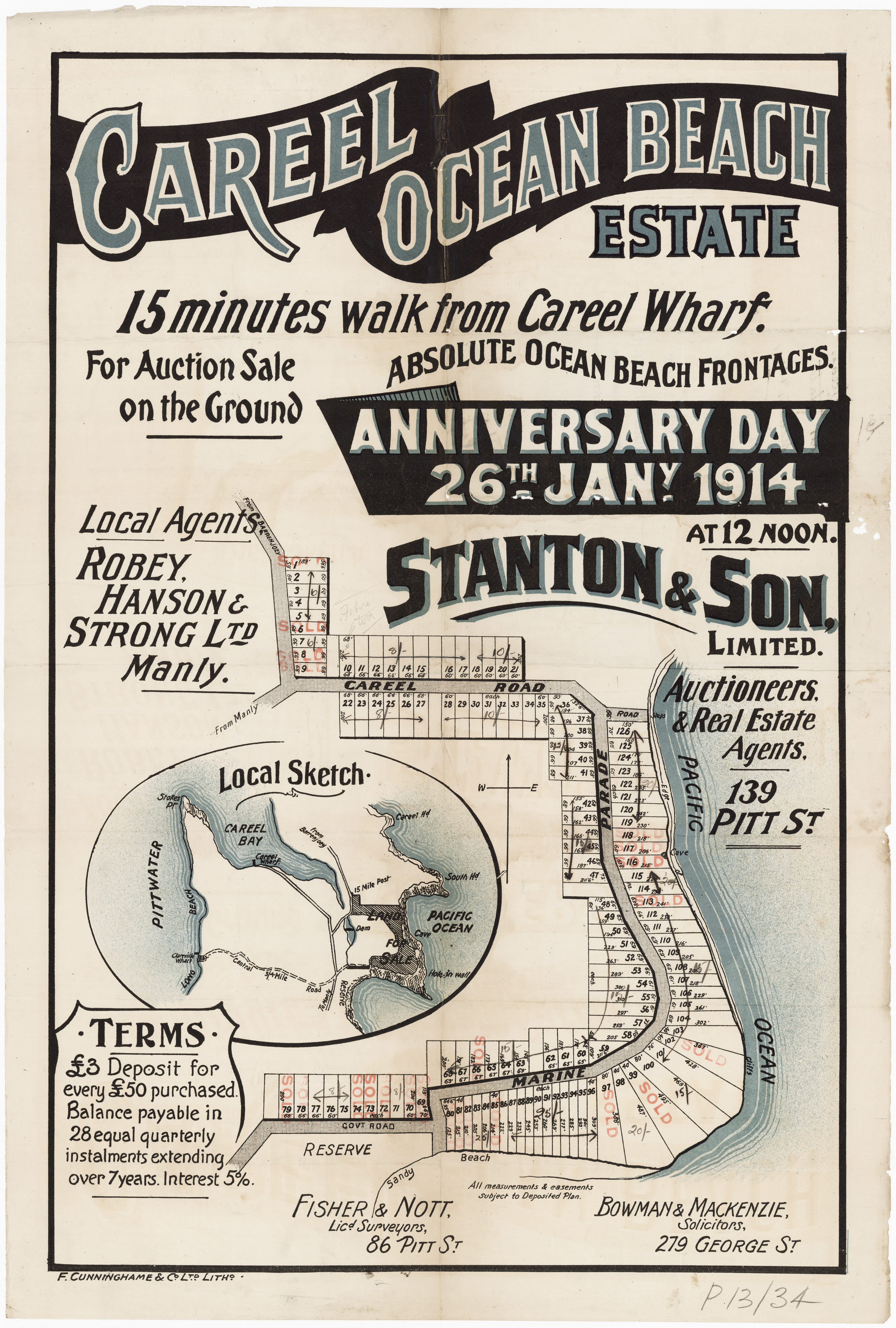
Avalon Subdivisions, Careel Ocean Estate 1914, Marine Road, Careel Road (now North Avalon Road) Item No.: c027560006h, courtesy State Library of NSW - Litho showing those that sold marked in red.
The full listing of those first land sales under Volume 2560 Folio 190 is available under extras. The first lots sold were Lots 78 and 79 to George Herriott Adamson, of North Sydney, Farmer, on June 12 1916 (Vol-Fol: 2688-67 - registered June 23, 1916). These two lots are those that are in prime position overlooking the beach and at the south entrance to Marine Parade. Lots 78 and 79 measure 2 roods 18 1/4 perches with a width of 164 feet and a length of 200 feet.
Mr. Adamson sells both of these on March 19 1930 to Arthur Jabez Small. The holding is transferred to his descendants, Arthur Geoffrey Small, Solicitor, his widow, Jessie Norrie Small, and Jessie May Cameron Small, 'spinster' and a John Stenhouse Benecke, Solicitor, on September 7 1954 - registered on December 25 of that year. On April 4th 1956 the property is placed in the children's names as 'tenants in common'; Arthur Geoffrey Small and Jessie May Cameron Small, with Winifred Newsham South and Muriel Hilda Hunt also added in.
Worth noting is No 1 Marine Parade sold by private treaty after being listed for just 5 days in 2004 in March 2006 for $3.625million. It hadn't been placed on the market for 20 years prior to that - in 1986. Conversely 21 Marine Parade North Avalon sold for $12, 375,000.00 on November 14 2025 - the listing describing a 5 bedroom 4 bedroom beachfront home on 1,150m² of land, with Council Rates now $7,197pa and Water Rates $817pa.
The next sale is to Henry Beecher Smith who buys Lot 72 on the same date (Vol-Fol: 2688-39), Sydney Collings Watkins of Hornsby, Medical Practitioner, buys Lots 97, 113 and 118 (Vol-Fol: 2688-40) on the same date, and all on Marine Parade - deposit registered June 30 1916, Certificate of Title August 10 1916. His only son, Ernest Sydney Watkins, also listed as 'Edward' in some documents, Clerk, sells Lot 97 on May 16 1923 and the other two to an Alan Malcolm Scott, Chartered Accountant, in 1949, who onsells both eventually.
Sydney Collings Watkins had been in the area for quite some time but seemed to be working in Katoomba by 1905, so may have bought the lots of land both as an investment and a means to have a place by the sea. He passed away April 1st 1921, at home, with his occupation also listed as 'Surgeon' by then - more than this under References and Extras:
Dr. Sydney Collins Watkins, of Manly, was yesterday fined £10 for failing to report a case of smallpox at Manly. MOBBING A SUCCESSFUL POLITICAL. CANDIDATE. (1888, May 12). Freeman's Journal (Sydney, NSW : 1850 - 1932), p. 10. Retrieved from http://nla.gov.au/nla.news-article115461851
WATKINS.-April 1, at Bedford, England. Sydney Collings Watkins, M.R.C.S., late of Hornsby, N.S. Wales, dearly beloved father of Edward S. Watkins, of 62A Manning-road, Double Bay, and Mary H. Watkins, 35, St. Cuthbert's, Bedford, England, aged 64 years. (By cable.) Family Notices (1921, April 6). The Sydney Morning Herald (NSW : 1842 - 1954), p. 10. Retrieved from http://nla.gov.au/nla.news-article15937337
Also listed among the first sales is Hannah Mary Breckenridge, wife of Henry Miles, who bought Lot 86, also on June 12 1916 (Vol-Fol: 2688-68), with Lot 87 was bought by Henry on April 27 1917 (Vol-Fol: 2760-174) while his sister-in-law, and wife of his brother Robert, Alice Mary Breckenridge bought Lot 88 on the same date (Vol-Fol: 2760-197).
Percy John Randolph Holdsworth bought Lot 6 on June 14th 1916, deposit made July 10 1916. Others went on for decades, with early sales recorded in the papers as:
Stanton and Son, Ltd, report, 15 lots in the Careel Ocean Beach Estate, with frontages of in all of 752 feet to Marine Parade for a total of £6781. REAL ESTATE. (1919, January 11). The Sydney Morning Herald (NSW : 1842 - 1954), p. 9. Retrieved fromhttp://nla.gov.au/nla.news-article15819701
For the sections west of today's Tasman Road, in Vol-Fol 4337-116 is 10 acres that goes to Arthur Jabez Small in 1926, alongside and west of Tasman Road, and then his children when he passes away, in 1955:
.jpg?timestamp=1778034318407)
.jpg?timestamp=1778034363255)
.jpg?timestamp=1778034433889)
.jpg?timestamp=1778034499507)
In Vol-Fol 2840-242 is 8 acres (part of Lots 3 and 4) alongside Careel Creek sold to John Daniel Fitzgerald on May 1st 1918 – current Catalina Cres and Barrenjoey High School site. Annie Matilda Hill of Darling Point becomes co-owner on August 6th 1919 and sells to Joseph Thompson of Pittwater on May 4th 1921, and later to Arthur Jabez Small in 1929:
.jpg?timestamp=1778034624365)
.jpg?timestamp=1778034671737)
.jpg?timestamp=1778034787813)
In Primary Application; PA 20950 is listed Emily Darvall & Florence Maud Callaghan 8 acres 24 1/2 perches at junction of roads from Manly to Careel Bay & to Barrenjoey in Shire Warringah Parish Narrabeen County Cumberland Volume 3108 Folios 86 & 87 – Lot 9. Contents Date Range: 19-06-1917 to 09-10-1920
.jpg?timestamp=1778036286960)
.jpg?timestamp=1778036326316)
They sell to 'Coast Lands Ltd' in March 1922 and it becomes Vol-Fol:3292-204, which shows on the Certificate of Title the dam is still in place on Careel Creek:
.jpg?timestamp=1778036383441)
.jpg?timestamp=1778036511435)
Harley Mackenzie passed away in 1916:
MACKENZIE - March 3 1916, at St Vincent's. Private Hospital Darlinghurst, Harley Usill Mackenzie aged 49 years. Family Notices (1916, March 4). The Sydney Morning Herald (NSW : 1842 - 1954), p. 16. Retrieved from http://nla.gov.au/nla.news-article15641578
MR. HARLEY MACKENZIE DEAD
The death of Mr. Harley Ursill Mackenzie, one of Sydney's best-known solicitors, and a member of the legal firm of Messrs. Bowman and Mackenzie, of this city, In St. Vincent's Private Hospital on Friday, was consequent upon an operation for appendicitis. Deceased who was in his 49th year, was a son of Dr. Mackenzie, of Sydney, and a brother of Lieutenant-Colonel Mackenzie, now at the front, and formerly Associate to Mr. Justice Gordon, Judge in Divorce. Mr. Mackenzie was well known in social and sporting circles in this State. The interment took place yesterday afternoon at Burwood, in the Church of England portion of the cemetery. The funeral was, large and representative, and Included many legal men. Amongst those who forwarded wreaths were the directors of the Hotel Pacific, Mr. and Mrs. Septimus Levy, Mr. and Mrs. Harry Levy, the management and staff of the Hotel Pacific, Dr. and Mrs. Herbert- Marks, Mr. and Mrs. Frank Macdonald, Mrs. and Miss Lewis, Mr. John Mackenzie. Misses Hay, Mr. and Mrs. J. B. Osborne, Mr. and Mrs. Phillip Morton, the guests of the Hotel Pacific, Rachael Joy Martin, Mr. and Mrs. Reginald Allen, the board of directors of the Royal Prince Alfred Hospital; Mr. Harry Chisholm, Mr. Venour Nathan, Mr. A. G. Andrews, Mr. Edwin Geach, Mr. and Mrs. Owen Prosser, and Misses Morton. MR. HARLEY MACKENZIE DEAD (1916, March 5). The Sun (Sydney, NSW : 1910 - 1954), p. 5 (SUNDAY EDITION). Retrieved from http://nla.gov.au/nla.news-article221360635
His brother William Kenneth Seaforth Mackenzie was left in charge of his estate.
John George Cousins also passed away in 1916 and his wife had to apply for bankruptcy on his estate:
[Notice under Section-11 of the Bankruptcy Act, 1898.]
In the Supreme Court of New South Wales. (21,042)
IN BANKRUPTCY.
Re estate of the late John George Cousins (deceased), late of 278 George-street, Sydney, warehouseman.
NOTICE is hereby given that a Sequestration Order has this day been made against the abovenamed estate, on the petition of the executrix, Mary Cousins, and Mr. C. F. W. Lloyd appointed to be the Official Assignee.—Dated at Sydney, this 17th day of January, 1917.
F. H. SALUSBURY, Registrar in Bankruptcy. IN BANKRUPTCY. (1917, January 19). Government Gazette of the State of New South Wales (Sydney, NSW : 1901 - 2001), p. 413. Retrieved from http://nla.gov.au/nla.news-article226035031
Sales continued under Volume 2560 Folio 190 until July 4th 1950, with George Henry Kennedy of Bondi, Chemist, purchasing Lot 76 (Vol-Fol: 6189-174) and selling to Rupert William Shaw and Edwin John Shaw, both Carriers and 'of Mona Vale', on August 15 1950, as the last listed under that Vol-Fol.
Some also went into Careel Bay Ocean Estate North Avalon Vol-Fol 3329-160, with sales from June 1922 - the map in the Certificate of Title for this Vol-Fol shows those lots of land left in this change between what had been jointly owned/on sale:
.jpg?timestamp=1778216836582)
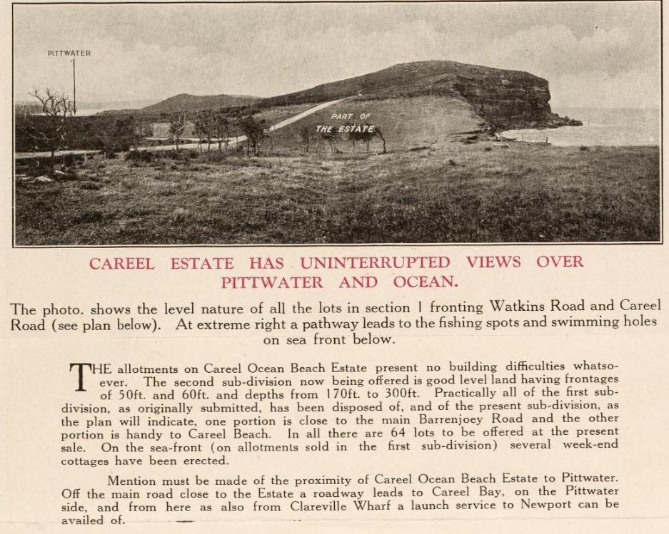
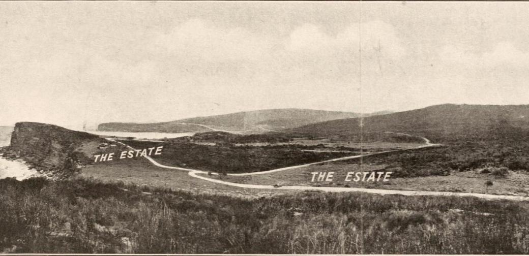
Once all the details of who would get what were sorted out, the second subdivision of the Careel Ocean Beach Estates commenced from 1922 and has some great photographs including in the pamphlets and lithographs prepared for the same.
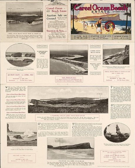
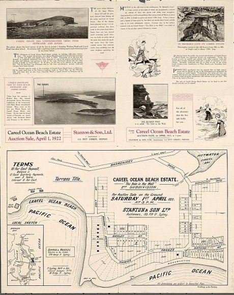
Stanton & Son. Careel Ocean Beach estate [cartographic material] : "The hole in the wall", 2nd subdivision, April st, 1922. MAP Folder 37, LFSP 499. Part 1. and Stanton & Son. Careel Ocean Beach estate [cartographic material] : "The hole in the wall", 2nd subdivision 1922. MAP Folder 37, LFSP 499. Part 2., courtesy National Library of Australia.
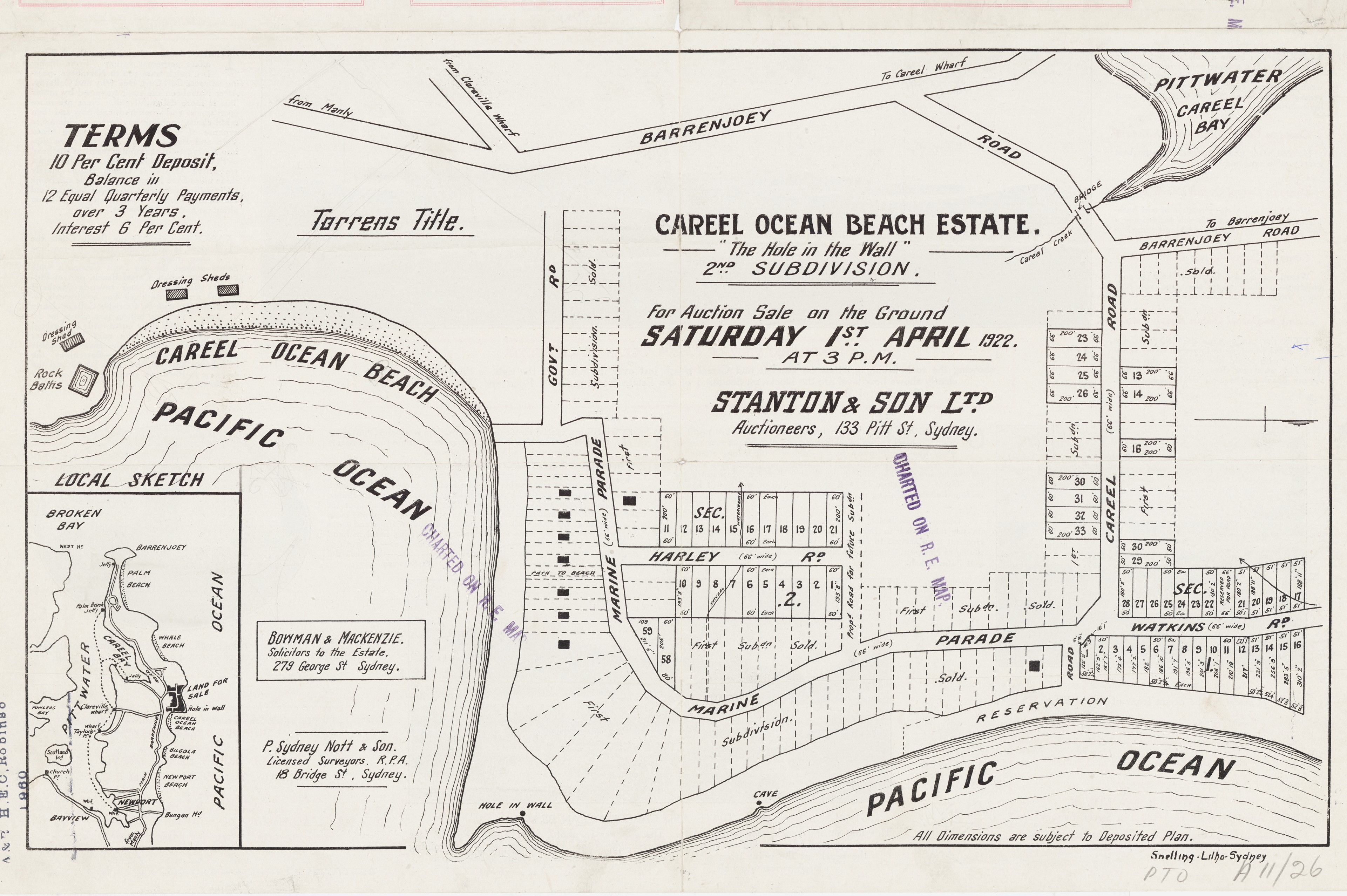
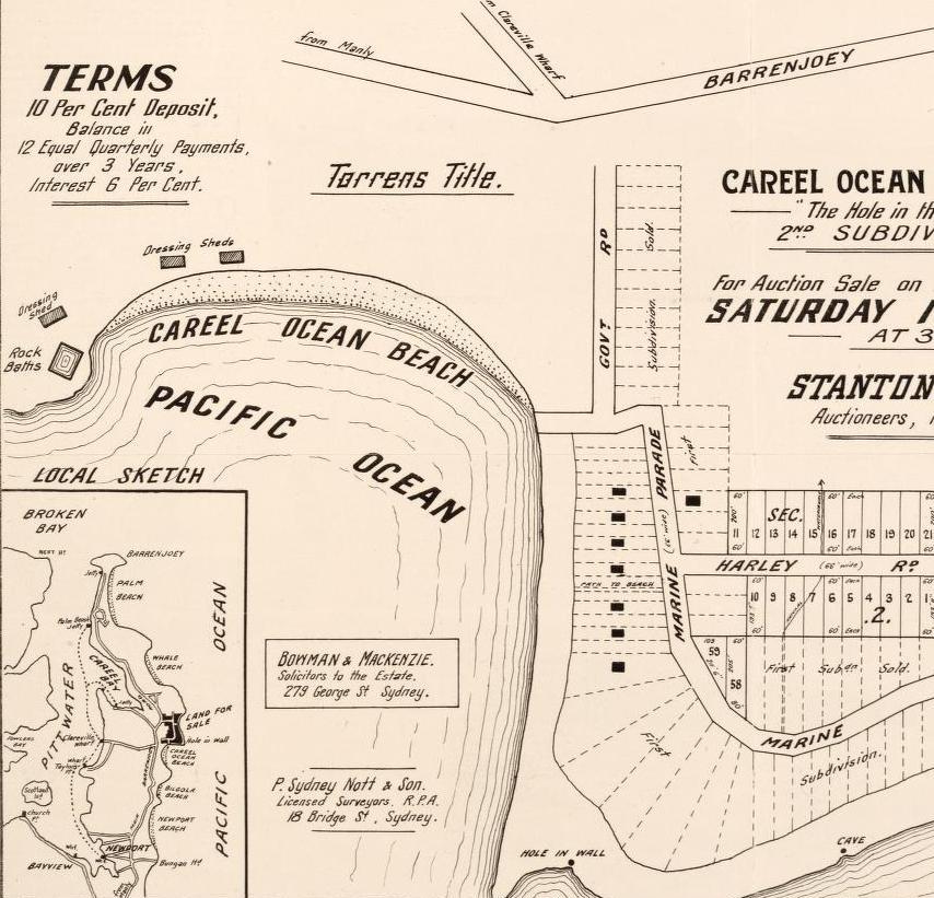
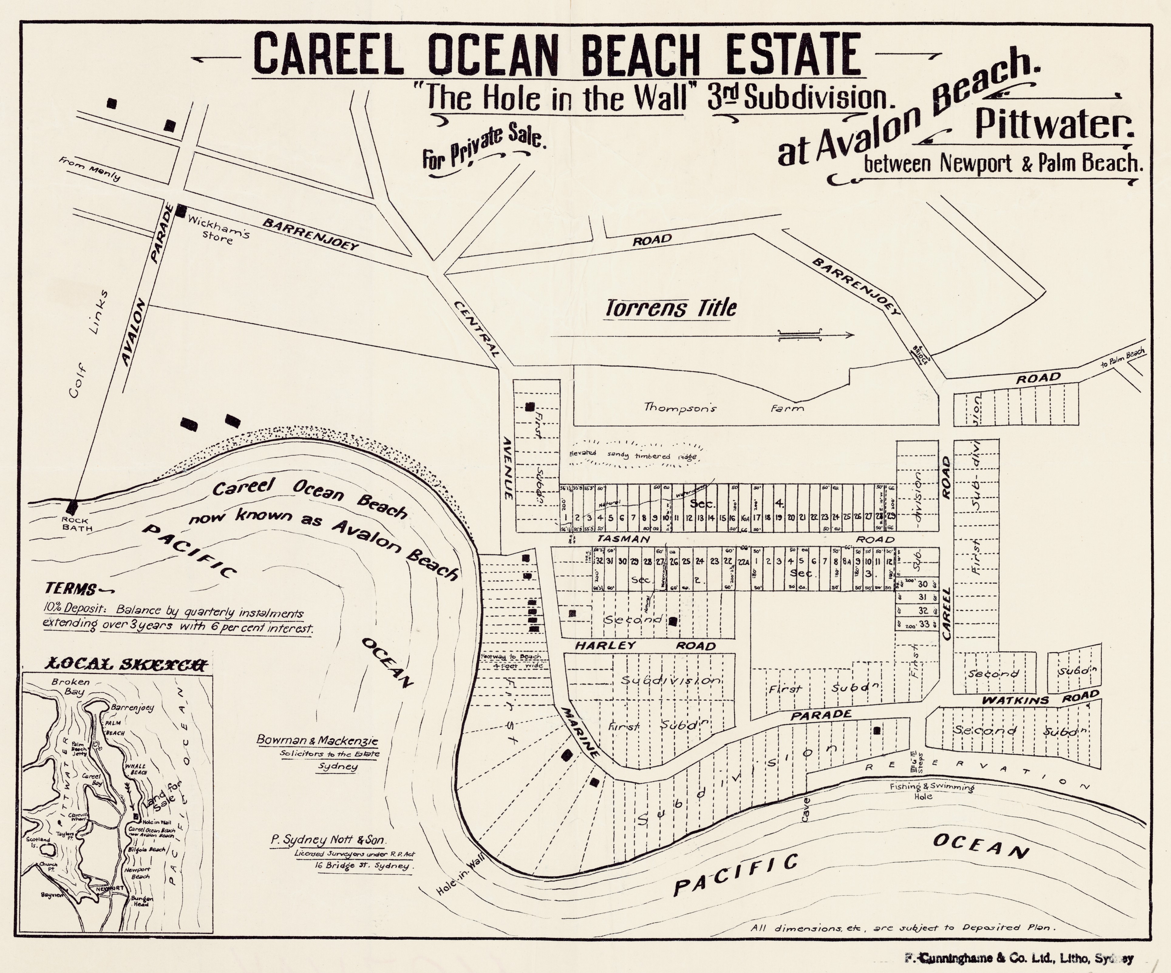
Careel Ocean Beach Estate - Central Ave, Careel Rd - 3rd Subdivision showing Harley Road and Watkins Road. Item No: c027560024, courtesy State Library of NSW
.jpg?timestamp=1778222330537)
.jpg?timestamp=1778223483003)
Behind the North Avalon Beach Dunes Creeks - 'Springs':
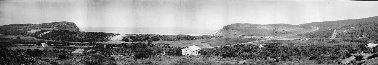
The water everywhere, including 'little streams that roared' or were noted as 'springs' in the 1914 land sales 'positives', can be seen in some of the water tracks that are visible in this panorama of Avalon Beach, which extends into the North Avalon Beach dune area and beyond.
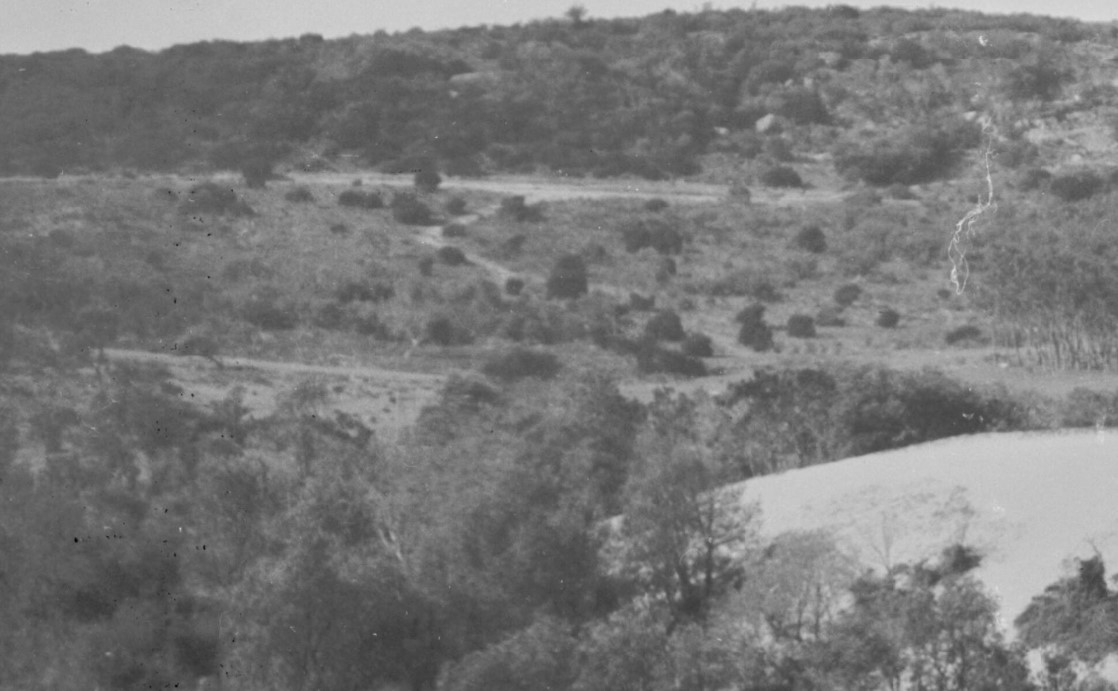
The 1922 Lithograph map of the lots of land shows the placement of the creek that ran from the south-beachward end of Marine parade down towards and behind the dunes:
.jpg?timestamp=1778224120903)
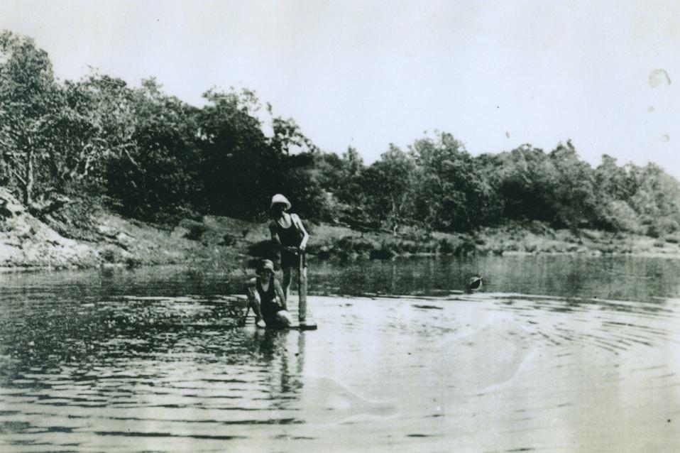
Geoff Searl OAM, President of Avalon Beach Historical Society, who has helped with this research, states:
‘This photo from the 1920s shows Miss Madge Breckenridge and a friend on their raft on the pond where water gathered at the bottom of Marine Parade against the Great Northern Spur’. It's looking northwest and Careel Creek would be flowing left to right behind the dune.
It’s possibly taken from what later became Tasman Road.''

Hannah and Henry had for children, two boys and two girls: Margaret Hare Breckenridge (born 1903 at 'Failford' the Brekenridge family property); Eileen Mary Breckenridge (born 1907); Thomas Major Lane Breckenridge (born 1911) and Ian Henry Breckenridge (born 1915).
The family business was in timber and mills for the same, called 'John Breckenridge and Sons' which his father, John Wylie Breckenbridge had started and which would have a business at Drummonye as well as the branches at Failford and Kendall. The "Commonwealth", built by Messrs. Breckenridge at Failford, was a twin-engined steamer of 100 tons. She was launched on 8th June 1901 and featured accommodation for 16 passengers in cabins and 6 in steerage.
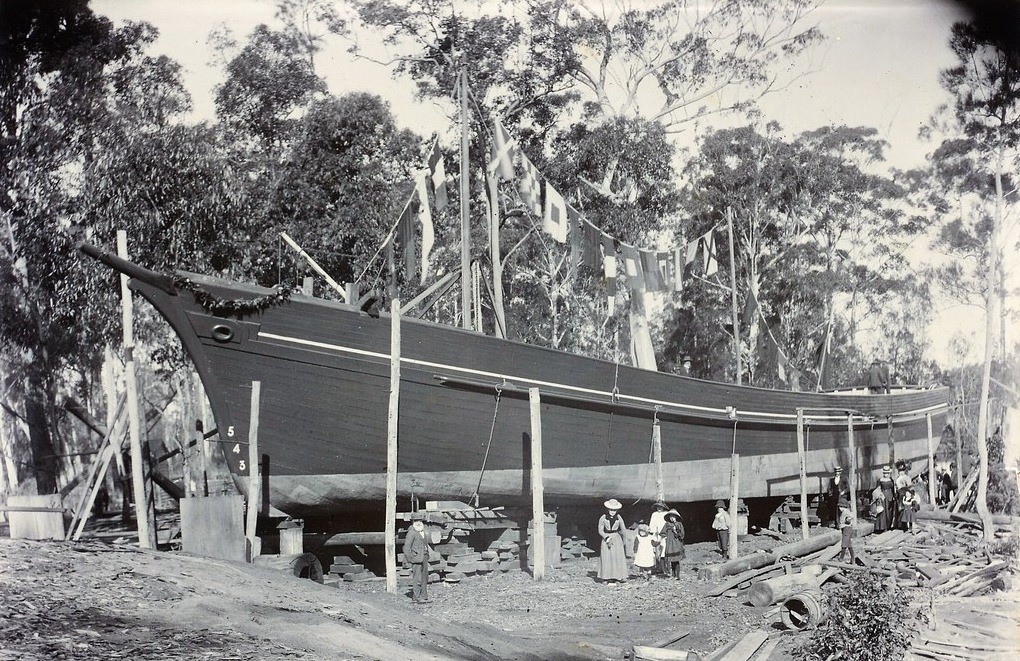
Commonwealth on launch day, 8th June 1901. The photo is displayed in the Mid North Coast Maritime Museum and has the following inscription:
'Breckenridge shipyard at Failford on the Wallamba River. The shipyard operated to construct ships for the Breckenridge line, between Cape Hawke and Camden Haven to Sydney. The ship here is the "COMMONWEALTH", which made weekly trips from Breckenridge's wharf at Drummoyne, Sydney, carrying cargo and passengers for Forster, Tuncurry, Nabiac, Krambach and Coolongolook.' (Photo J. W. Breckenridge), Failford.
Researchers state it was John W. jnr., their eldest son, who built ships here. Henry Breckenbridge would also build, himself, a three-masted schooner call the 'Jap', which was converted into a steamship which would ply between Camden Haven and Drummonye carrying lumber.
Their father, John Wylie Breckenridge, was called the 'Father of Forster' and indeed, named one of his sons after Forster. He was a prominent 19th-century timber magnate who established the village of Failford on the Wallamba River in New South Wales, during the 1880s. The Breckenridge family built a massive milling, shipping, and shipbuilding empire in the region. Failford was named after a village in Scotland with family connections.
This enabled those sons who moved to Sydney to look after this end of the business to purchase property.
Tragically, Henry and Hannah's eldest son Thomas died by falling from North Avalon Headland while chasing a goat on December 3, 1921, aged just 10. The Coroner's Inquest found his fall, near 'Hole-in-the-Wall', was an accident.
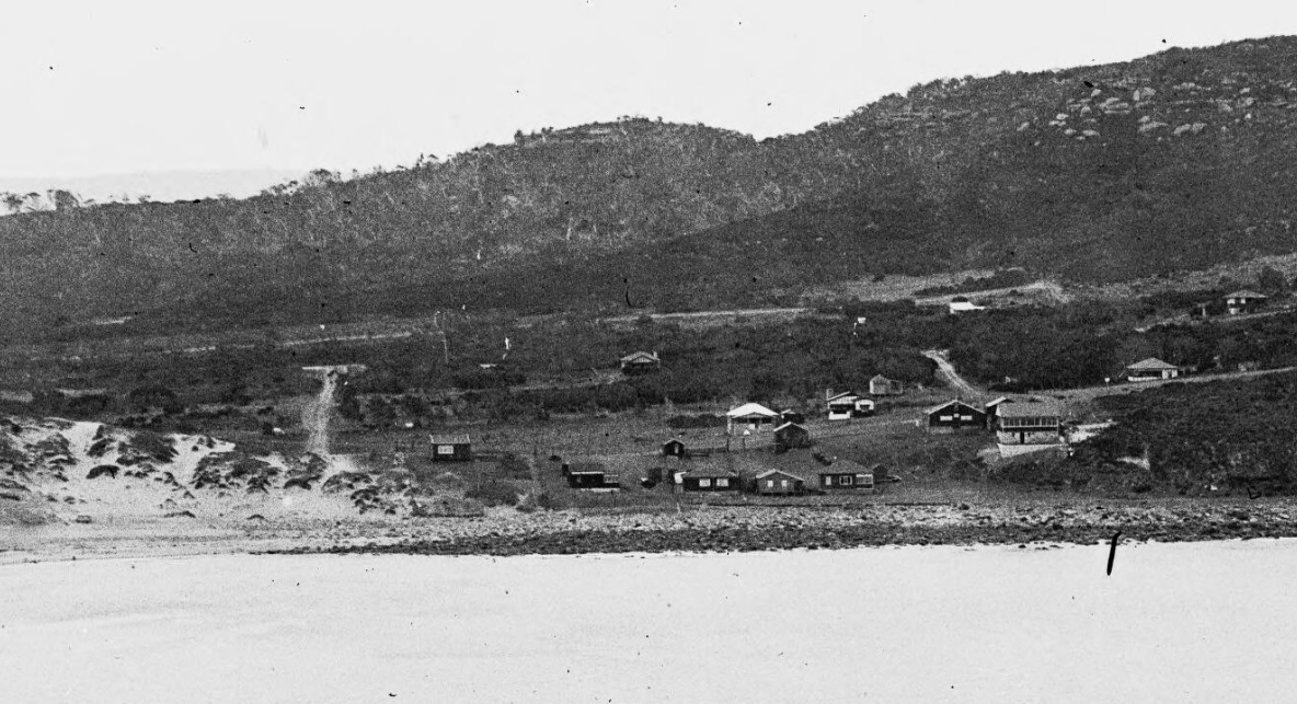
Avalon Pano 1 - Geoff Searl OAM, ABHS: '' This is part of a super panorama taken from the top of North Avalon Beach headland looking almost due west. In the foreground is a rough old Marine Parade, with a rather clean Harley Road ducking off to the right. There is the tiniest hint of Tasman Road to the right of the cottage which picks up the fence line at the bottom of Marine Parade.''
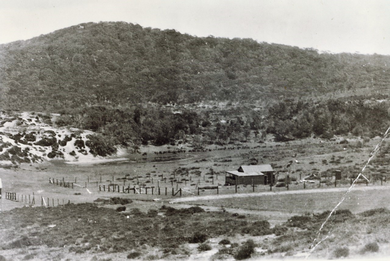
Almost in the middle of the picture is the pond on which Madge and her friend were paddling about on.
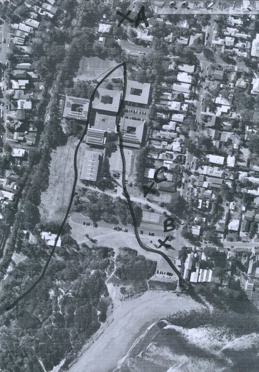
C and B: This might make it simpler or totally confusing! C is approx.. where the raft was photographed looking towards the top of the scan. B is where the dune would be at its tallest and again looking towards the top of the scan. A is where the photographer would have stood to take the pic looking back towards the North Av car park/dune with the northern end of the dune in the right of pic.
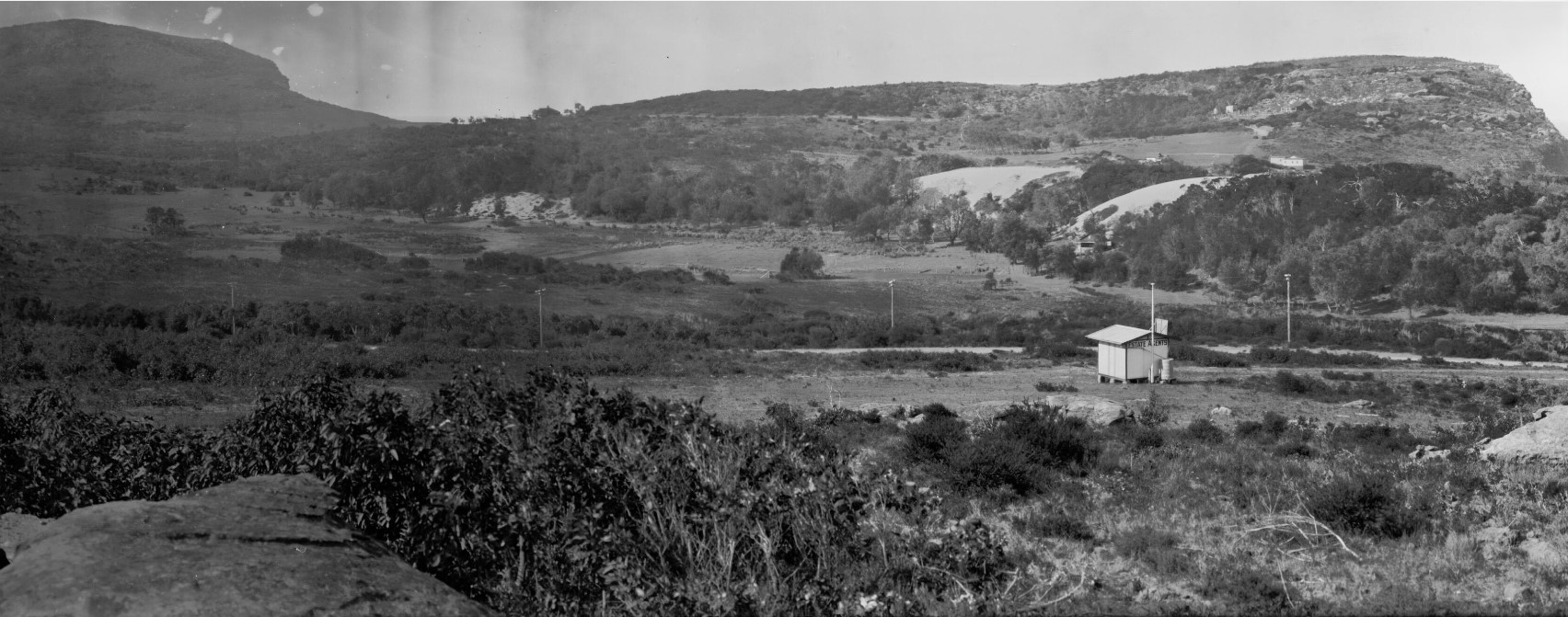
Geoff Searl OAM: ''Here are 2 pics which have written Dale Kentwell’s name on the back.
The first one looks as though you are looking along the line of the dune with the imaginary raft off to the right. Sure the dune is taller in this one but probably because the picture is being taken closer to the North Avalon Beach (carpark) looking away along to the north west.

Number 2 could have been taken towards the end of the dune looking back towards the later car park area with the beach behind the distant dune:
 Watkins road north av.JPG?timestamp=1778223667528)
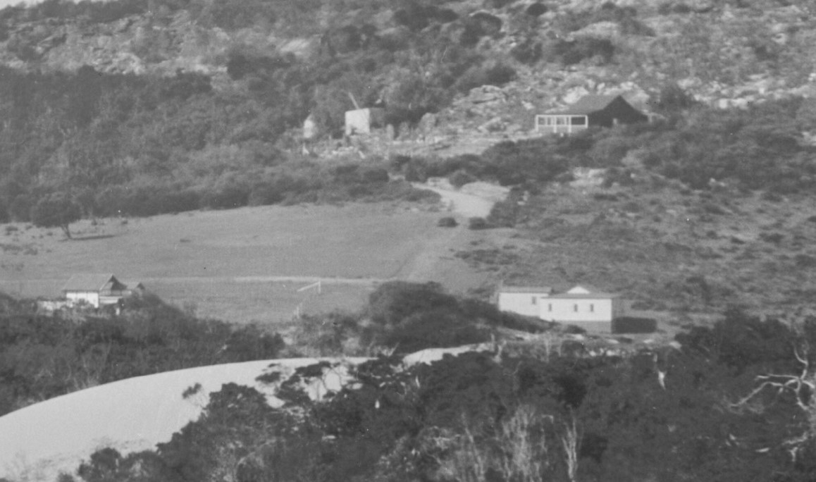
1920's view along Watkins road - the house belongs to the Collins family. Note the ditch to the left side of the track where another creek would run when it rained from Bangalley headland. ABHS photo
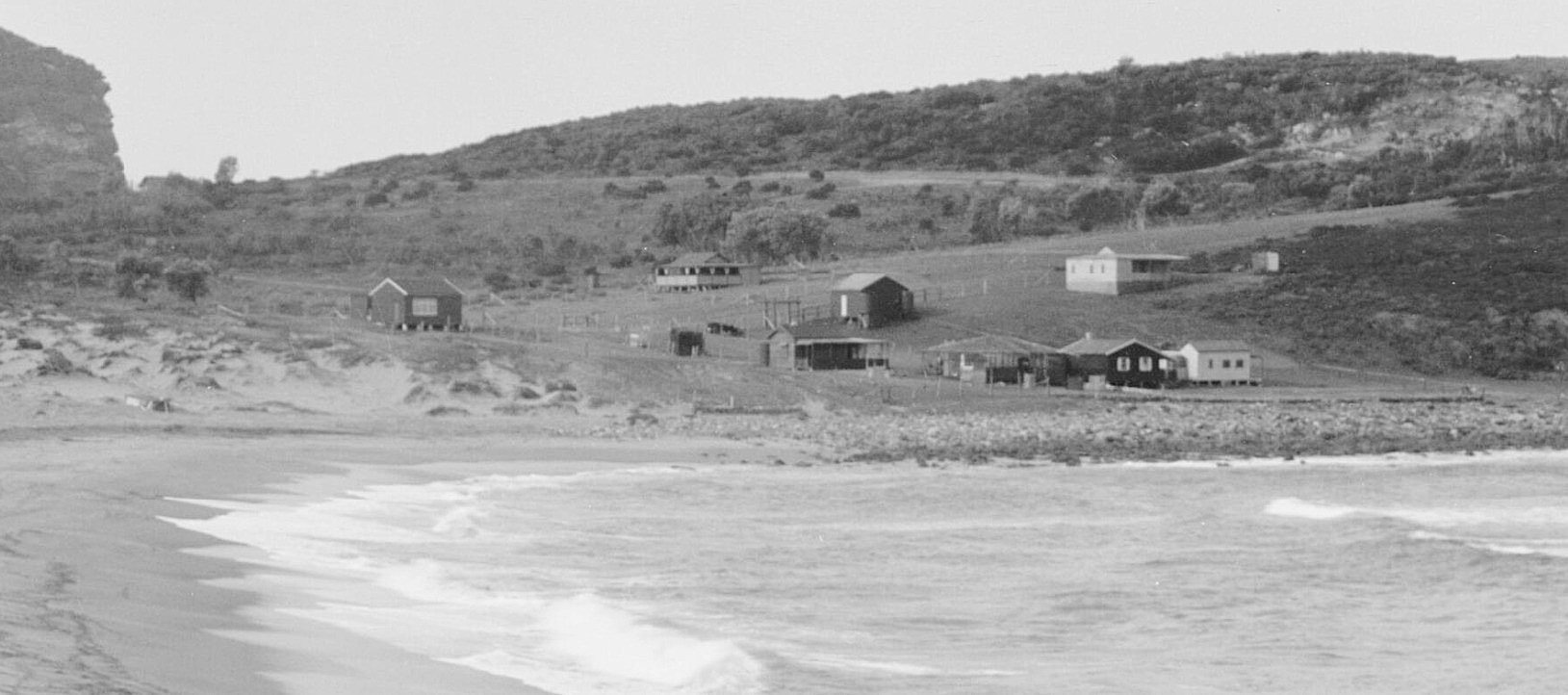
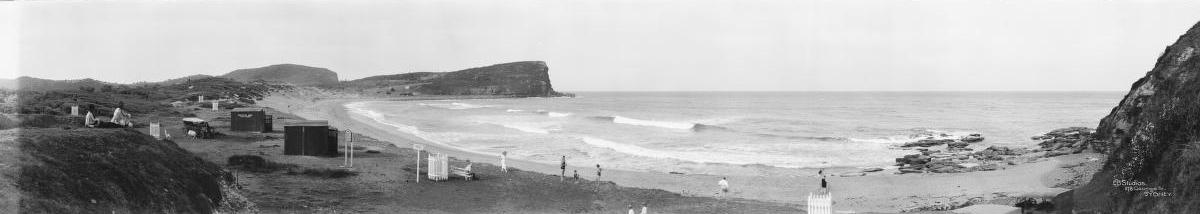
North Avalon Beach - Section from 'Panorama of beachgoers at Avalon Beach', New South Wales, ca. 1921-25 section enlarged to show details. Image No.: nla.pic-vn6217968 by EB Studios, part of the Enemark collection of panoramic photographs, courtesy National Library of Australia Retrieved from http://nla.gov.au/nla.obj-162503014
North Avalon circa 1928. Photo: C Piggott
Changes to the landscape
The original Collins dam appears to have stayed in place until water was put on to Avalon Beach valley in 1934 and the road was changed to run straight from where it once dipped down towards North Avalon Road and Bangalley Way in 1937-38. See: Avalon's 'Telford' Road to have signage about its Heritage

Part of the land came from James Young, one of the original Directors of the Barrenjoey Land Company, a relative of Mr. Wolstenholme, who was in turn a son of Maybanke Anderson, and a barrister by profession, who served as President of Ku-ring-gai Council at one time, who sold land to the council.
The Minutes of the Warringah Shire Council Meeting of 27th October,1924 record: ''The President verbally reported having interviewed Mr. James Young and submitted a letter from Mr. Young, offering to sell his 10 ¾ acres at Careel Bay fronting Barrenjoey Road for £700 on terms, namely, £50 deposit, and the balance in annual instalments of £100 each with interest at 6 ½ % on unpaid purchase money. It was resolved, - (Crs. Hewitt, Hitchcock) That the offer be accepted and the terms approved, but that the President endeavour to arrange for a smaller deposit. ''
This was formalised in 1926: Volume 3,847, folio 56 shows the land James Young and Robert Browning (Palm Beach Land Co - follow on from Barrenjoey Land Co.) sold to the then council.
Volume 3,847, folio 56:
.jpg?timestamp=1747794855081)
.jpg?timestamp=1747794893300)
.jpg?timestamp=1747795053160)
.jpg?timestamp=1747795122664)
.jpg?timestamp=1747795167692)
The Certificate of Title above also shows part of this was resumed in 1936 for roadworks - and this was when the route of the Barrenjoey road was changed as well as being where and when the Careel Creek road bridge and concrete drainage pipe was placed with works completed on March 10 1938 - this concrete drainway/road-bridge is still in place:
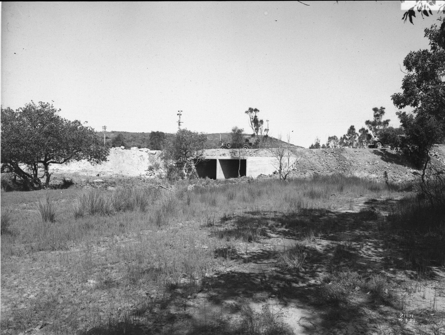
'Careel Creek looking south' 10.3.1938 - also new section of Barrenjoey Road being built - Item: FL3663714, courtesy NSW Records and Archives
.JPG?timestamp=1747796015819)
Same drain - May 2025 (during investigation works for upcoming Pittwater creeks history pages).
Crown Land Aerial Section, showing this side of George street/Careel Creek with the 'Telford' road circled in red (old route of Barrenjoey road) marked in red. Dated 5.1.1951
Worth noting from the same council's minutes of meetings is how the changes occurred and that triangular piece of land where the North Avalon bus stop is was formed:
Main Roads Department, 16/6/37, forwarding for Council's information, copy of plan shoving the portion of Hitchcock Park Careel Bay, resumed for main road purposes. Resolved, Hitchcock' That the Department be asked to beautify the small triangular-cornered piece severed from the park by the deviation of the road. (Crs. Hitchcock, Ross)
.JPG?timestamp=1769107663295)
That triangular cornered piece at corner of Barrenjoey road and North Avalon Road - Bangalley Way is the carriageway seen at the front of the first photo - See History page: Careel Bay Playing Fields Reserve - Including Hitchcock Park: Birds, Boots & Beauty
A few years later, the Warringah Shire Council minutes of Meetings held on November 20th, 1933 record: By Cr. Hitchcock - That the preparation of plans for drainage at Wilshire Park and Glenburnie Park be expedited. Careel Park; by Cr. Hitchcock - That plans for dredging Careel Park be prepared as soon as possible.
Sand Dunes carted away
Rupert William Shaw and Edwin John Shaw, 'Carriers' of Mona Vale, who bought Lot 76,
But it wasn't the little creeks at North Avalon Beach, and the subsequent pools the Breckenridge girls played in, that caused problems, although the areas they flowed into will still fill up outside those creeklines when rains fill the landscape.
The whole of the Avalon Beach valley flows towards and into Careel Bay. The council's aspirational plans for Careel Creek in the Avalon Place Plan, along with recent rains, show where the old creeks and drainage lines once flowed.
Arthur Jabez Small, who subdivided so much of Avalon into suburban blocks, recommended culverts and drainage at the south end of the beach from early on. See: Pittwater Beach Reserves have been dedicated for public use since 1887 - no 1.: Avalon Beach Reserve- Bequeathed by John Therry
In the Avalon Beach shopping area Warringah Shire council's Minutes of Meetings record an insight into a problem that still hadn't been fixed:
30/4/1928: 40.,Garland, Seaborn & Abbott 13/4/28 Suggesting certain drainage improvements at Avalon Beach to prevent damage to A J Small's property. Resolved Crs. Hitchcock, That the Engineer furnish an estimate of the cost, and the work of cutting the drain be put in hand immediately the transfer is finalised.
62. Garland. Seaborn & Abbott. 29/6/28. Again requesting that the Shire Engineer confer with the green-keeper of Avalon Beach golf links in regard to defective drainage. Referred to the Overseer for attention.
18. Main Roads Board. 16/7/28. Advising that the length of Barrenjoey Road which is proposed to be proclaimed a main road is that extending from Newport to the end of the last at deviation at Avalon. Resolved: (Crs. Hitchcock, Atkins) - That an application be made to have the whole length of Barrenjoey Road proclaimed a main road. 20. H.E. Fry. 12/7/28. Requesting a garage approach to 57, Avalon Beach Estate. Referred to the Overseer for report.
23/7/1928: 45. Garland. Seaborn & Abbott. 10/7/28. Suggesting, as a temporary measure to relieve the drainage trouble at Avalon Beach, that a drain be cut from the junction of Barrenjoey Road deviation and Avalon Parade to the 25-ft.easement opposite the tennis courts. Left with the Engineer to deal with
By May 1934 the following ran in the NSW Gazette:
Department of Public Health,
Sydney, 23rd May, 1934.
PUBLIC HEALTH ACT; 1902, SECTION 55.
Unhealthy building land at Avalon, fronting Barrenjoey-road, Old Barrenjoey road, Avalon-parade and Central-road, Shire of Warringah.
THE Board of Health have reported that after due inquiry, they are of opinion that it would be prejudicial to health it certain land situated in the Shire of Warringah, and described in Schedules hereunder, were built upon in its present condition.
The Board of Health hare further reported that in order to render such land fit to be built upon it is necessary that:—
(a) the land be drained by properly constructed stormwater channels of capacity sufficient to carry off all water passing over the area;
(b) The surface of the land comprised in Schedule 1 be raised with clean soil or sand to conform to the following grades—
1. at Barrenjoey-road and Old Barrenjoey road to the height of the adjacent crown of those roads, rising therefrom on a grade of one in 100;
2. at the drainage easement or lane to a height 3 inches above the natural surface of the land, rising therefrom on a grade of one in 100;
(c) the surface of the land comprised in Schedule 2 be raised with clean soil or sand at the watercourse to a height 3 inches above the natural surface, rising therefrom on a grade of one in 100;
(d) all floors be laid 011 joists, the undersides of which shall be not less than 18 inches above the surface of the land when raised;
(e) the whole of the work be done to the satisfaction of the Board of Health.
Now, therefore, in pursuance of the power and authority vested in me by section 55 (1) of the Public Health Act, 1902, I hereby declare that such land shall not be built upon until the measures above referred to which are also specified in a document deposited in the office of the Local Authority (the Council of the Shire of Warringah) and open to, the inspection of any person, have been complied with, or until this notice has been revoked by me.
R. W. D. WEAVER, Minister for Health.
Schedule No. 1.
Commencing at a point 011 the north-western side of Old Barrenjoey road, being the southernmost corner of lot 10, d.p. 9,151; and bounded thence 011 the south-west by the south-western boundary of Jot 10 north-westerly to lane; thence by that lane north-easterly to Avalon-parade; thence by a line north-easterly to the westernmost corner of lot 13; thenee by lane north-easterly to the northernmost corner of lot 20; thence by part of the north-eastern boundary of lot 20 south-easterly to a point 135 feet along that boundary north-westerly from Barrenjoey-road; thence by a line north-easterly to a point on the south-western boundary of lot 22, being 70 feet along that boundary from Barrenjoey-road thence by that boundary south-easterly to Barrenjoey Road; thence by lines bearing consecutively 37 degrees 185 feet, 47 degrees 310 feet, 122 degrees 125 feet, 189 degrees 250 feet, 196 degrees 0*50 feet; thence by a line southwesterly to the easternmost corner of lot*8, d.p. 13,975; thence by the south-eastern and south-western boundaries of lot 8 to the westernmost corner of lot 8; thence by a line south-westerly to the southernmost corner of lot 13, d.p. 12,047; thence by lane south-westerly to the*southernmost corner of lot "21; thence by the south-western boundary of lot 21 north-westerly' to Old Barrenjoey road; thence by Old Barren joey road north-easterly to the westernmost corner of lot 13; thence by a line northwesterly, to the point of commencement.
Schedule No. 2.
Commencing at a point on the north-eastern side of Avalon-parade, being the westernmost corner of lot 33, d.p. 9,151; and bounded thence on the soutli-west by Avalon-parade north-westerly to the westernmost corner of lot 52; thence by the north-western boundary of lot 52 north-easterly 80 feet; thence by a line parallel to Avalon-parade north-westerly to the south-eastern boundary of lot 60; thence by a line north-westerly to the north-western boundary of lot 66, beings point 190 feet north-easterly along that boundary from Avalon-parade; thence by that boundary north-easterly 430 feet; thence by a line south-easterly to the south-eastern boundary of lot 37, being a point 30 feet north-easterly from the southernmost corner of lot 37; thence by a line parallel to the south-western boundary of lot 36 south-easterly to the south-eastern boundary of lot 34; thence by a line south-easterly to the southernmost corner of lot 33; thence by a line bearing 116 degrees 160 feet; and by a line north-easterly to the northernmost corner of lot 20; thence by lane south-westerly, to the point of commencement. PUBLIC HEALTH ACT, 1902, SECTION 55. (1934, May 25). Government Gazette of the State of New South Wales (Sydney, NSW : 1901 - 2001), p. 2030. Retrieved from http://nla.gov.au/nla.news-article223060059
This state of flooding still persists today, even with the creeks that thread through the valley placed in pipes, and Careel Creek in the most noticeable open drain that still runs alongside the Reserve, that will still overflow into the green areas alongside it, and even onto the homes built backing on to the same.
When the reserve was used for camping people living there permanently during the 1930's, due to the economic depression, and after World War Two, due to a lack of materials to build new homes with. Permanent residents recalled their possessions and even the people being washed right along Careel creek; some even stating they were washed out into Careel Bay.
A few examples:
THEY SUFFERED DISCOMFORT FROM THE RAIN: Mr. Syd Forrester, of Leichhardt, digging a trench during heavy rain in an effort to prevent the flooding of his tent at the Avalon camping ground yesterday.
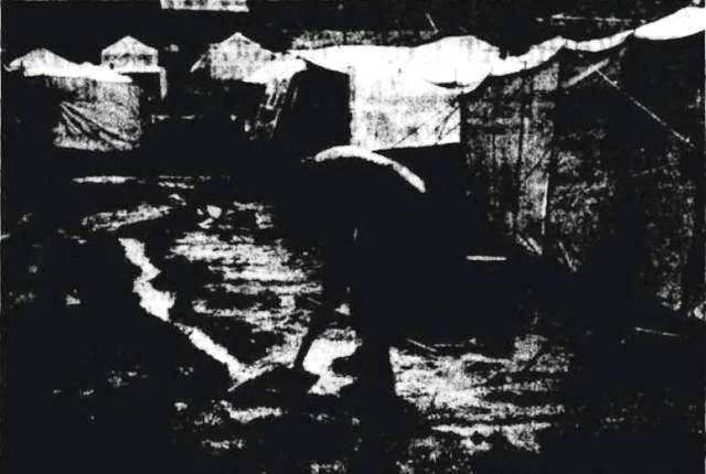
The occupants of six of the 90 tents on the reserve left for home. THEY SUFFERED DISCOMFORT FROM THE RAIN. (1948, January 15). The Sydney Morning Herald, p. 3. Retrieved from http://nla.gov.au/nla.news-article18057497
Freak Storm Hits Avalon: Drives Out Tent Dwellers
A freak hailstorm yesterday flooded many parts of Avalon, doing hundreds of pounds' worth of damage. Scores of people living in the camping area at Avalon were forced to leave their homes. Tents were torn to-shreds and the roofs of caravans severely damaged. Several tents and the furniture inside them were washed out to sea by floodwaters. Most of the families living in the camping area were given shelter for the night in the Avalon surf shed.
Mrs. Joyce Andries, of the Avalon Fire Station, said last night that immediately residents realised the floodwaters were rising, volunteers raced to the camping area to help to evacuate the children. The children were carried to safety through the racing water. Most of them were taken to the Avalon surf sheds, and the remainder were taken to the homes of relatives and friends.
Among the worst sufferers in the camping area were Mr. and Mrs. V. Harrington, who estimated their losses at about £.250. Their tent was not washed away, but damage to the roofing, sides and floor coverings was "enormous," said Mr. Harrington. The roof of Harrington’s tent was torn to shreds by the hailstones while water roared over the floor, destroying floor coverings and food supplies. Mr. Harrington had to use a suction pump to clear the water from the tent. He said he had only just cleaned up and repaired the damage done by last Saturday morning's floods. The storm began shortly after 2 p.m. and lasted for nearly three and a half hours.
Hailstones, measuring almost two and a half inches across, rained on the shopping and camping centres. Stormwater, in places three feet deep, raced through the shopping centre, flooding shops and homes. Hundreds of pounds' worth of stock in the shops was destroyed. Road traffic from Palm Beach and Sydney was dislocated. Vehicles were unable to pass Avalon.
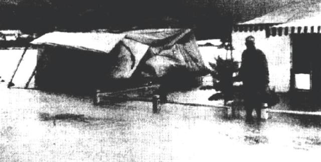
The tent on the left, owned by Mr D. Needham, was completely capsized by the rushing waters.
One of the shops which suffered most damage was Le Clercq's general merchandise store in Avalon Parade. Mr. Le Clercq, the owner, bored holes in the floorboards in an attempt to drain away the two feet of water which was damaging his goods.
He said he had only just cleaned up the debris from a flood which occurred on Friday. He had suffered more than £250 worth of damage in that flood.
The rush of water through Avalon Parade was so great at one stage that several cars were almost submerged. The swirling flood carried one car almost 200 yards before dumping it on the pavement. Freak Storm Hits Avalon: Drives Out Tent Dwellers. (1953, May 7). The Sydney Morning Herald, p. 1. Retrieved from http://nla.gov.au/nla.news-article18372783
Careel Creek alongside Avalon Beach Reserve in March 8, 2022:
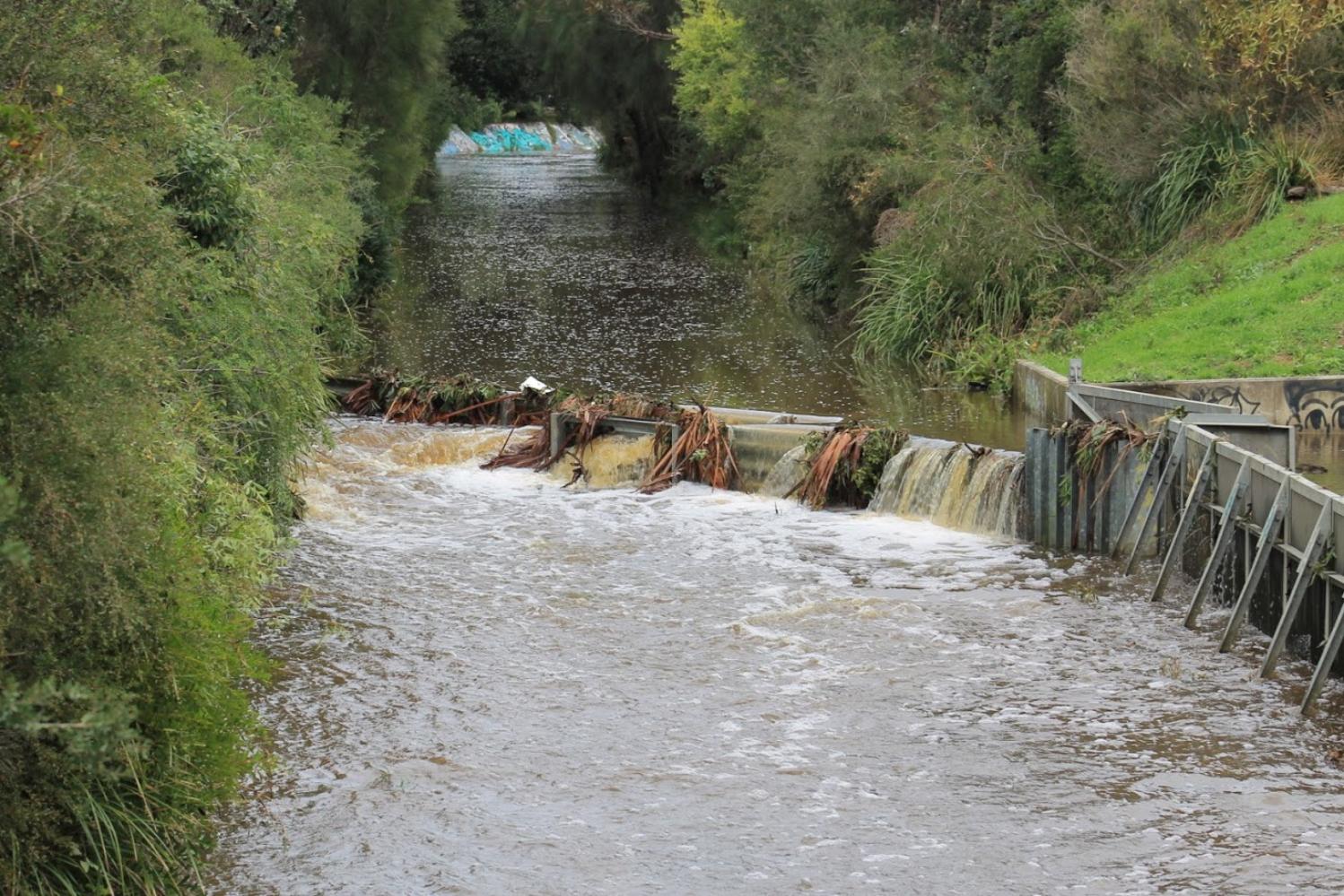

Mrs Matilda (May) Metcalf, an Avalon Beach resident during Summer holidays who would later move there permanently. A sample from Council's minutes from before and during WWII shows hers was a block of land that was alongside the creek that wended from the far end of the flat at Avalon Beach (Dunbar Park) to Careel Creek. Although she was clearly a community focused person there were ongoing problems her correspondence indicates she attributed to the installation of pipes by the Council:
Mrs. M. Metcalf. 3/1/25 requesting approval to the alteration of the site of the 20-ft. lane on the n. side of her property, Lot 21, to the s. side of lot 20, Clareville Ocean Beach Estate, Avalon: Referred to the Engineer.
Avalon Flat Drainage: Mrs. M. Metcalf, 11/9/36, further re drainage at Avalon Beach, requesting a copy of an alleged agreement between the Council and herself in 1931, whereby she accepted the sum of £25 as compensation on the condition that the Council abate the nuisance. Resolved, - That information regarding the alleged agreement be supplied at the next meeting of the Council.
Water Conservation & Irrigation Commission, 21/8/39, further in regard to the Council's action in constructing a diversion channel offtaking from an unnamed watercourse in Avalon Park, Avalon and replying that the name of the complainant in the matter is Drainage Mrs. M. Metcalf. Resolved, - That the Commission be informed the Council does not desire to proceed with its application for a license under the Water Act, and that the mouth of the diversion channel be closed for about 5 yards, as recommended by the Engineer.
Mrs, I.M.Watermen, 24/10/40, inquiring whether Mrs. Metcalf has the Council's permission to close the lane adjacent to her place and convert it to her own use pointing out that this lane provides a short cut to Avalon beach for a number of the residents. Resolved, - That the Works Committee make an inspection and report to next meeting. (Crs.Campbell, Bathe) 18. Mrs. M. Metcalf, inquiring whether council proposes to proceed with repairs to the bridge across the water channel on her land, the bridge being in a dangerous condition. Resolved, That Mrs. Metcalf be asked on what grounds she makes her request.
Mrs. I.E..Waterman, 7/3/41, again complaining of obstruction of lane at Avalon, and stating that from what she can gather, the person responsible for the obstructions is determined to give the Council as much trouble as possible. Resolved - That Mrs. Metcalf be requested to expedite the removal of the obstructions in accordance with a promise which she made to the Works Committee.
S. C. Taperell, Solicitor, 15/4/42, an behalf of Mrs. K. Metcalf, of Avalon, advising that considerable damage was done to his client's land at Avalon by the negligence of the Council in connection-with certain channels and drains on and about the land of his client and adjoining land, and requesting that the Council make an adequate offer of compensation in respect of such damage. Resolved, - That the matter be referred to the Insurance Company.
S. C. Taperell. Solicitor, 13/5/42, giving notice of intended District Court action against the Council for compensation for alleged damage to property at Barrenjoey Road, Avalon owned by Mrs. M. Metcalf, by Council's drainage system: The Shire Clerk reported that a copy had been sent to the Insurance Company for attention under the Public Risk policy, and the letter was 'received'.
Mrs.M. Metcalf, 28/5/43, reporting that the bridges on her property at Avalon Beach are dangerous, and enquiring if Council can help her in the matter, Resolved, -That a letter be sent to Mrs. Metcalf stating Council would like to help her but as the bridges are on private property it is unable to comply with her request.
Mrs. M. Metcalf, 6/6/46, drawing attention to the failure of the constructed drain on Council's property at Avalon to carry away flood waters, and that six pipes are concentrating the water into the creek through her property. Resolved, She be informed of the Engineer's report that this land is very low-lying and would fill with ordinary rain without any overflow from Council's drain.
Marshall, Marks & Jones 9/12/47 saying that as no reply. as been received to their letter Re; Mrs. Metcalf, she has been instructed to call for tenders and have the necessary work done, and that the Council will be looked to for payment for such work. Resolved: That the blackberries be removed from the footpath and the Solicitors informed that the Works Committee could find no trace of damage to the fence when an inspection was made.
A few other insights in Mrs M. Metcalf provide that she was appointed an Honorary Ranger in 1944 under the Birds and Animals Protection Act, and:
DISTRICT COURT.
(Before Judge While.)
ACTION AGAINST COUNCIL.
The hearing was continued of the action In which May Metcalf of Oxford-street, Woollahara, sued the Warringah Shire Council for £.160 damages for alleged faulty construction of roads and drains, which resulted in the flooding of her garden at 'St Jerome' Barrenjoey-road Avalon. The defendant council denied negligence, and pleaded contributory negligence and waiver by plaintiff. Judgment was reserved. Mr Howard Beale (instructed by Mr David Campbell) appeared for plaintiff, and Mr Bryan Cruller (Instructed by Messrs Dawson, Waldron, Edwards, and Nicholas) for defendant council. DISTRICT COURT. (1934, June 1). The Sydney Morning Herald (NSW : 1842 - 1954), p. 7. Retrieved from http://nla.gov.au/nla.news-article17067952
COTTAGES
photo: Government Printing Office d1_45760 - Avalon [From NSW Government Printer series: Government. Insurance.] Contents Date Range 01-01-1948 to 31-12-1948
Department of Public Health, Sydney, 23rd May, 1934.
PUBLIC HEALTH ACT; 1902, SECTION 55.
Unhealthy building land at Avalon, fronting Barrenjoey-road, Old Barrenjoey road, Avalon-parade and Central-road, Shire of Warringah.
THE Board of Health have reported that after due inquiry, they are of opinion that it would be prejudicial to health it certain land situated in the Shire of Warringah, and described in Schedules hereunder, were built up on in its present condition.
The Board of Health hare further reported that in order to render such land fit to be built upon it is necessary that:—
(a) the land be drained by properly constructed storms water channels of capacity sufficient to carry off all water passing over the area;
(b) The surface of the land comprised in Schedule be raised with clean soil or sand to conform to the following grades—
1. at Barren joey-road and Old Barrenjoey road to the height of the adjacent crown of those roads, rising therefrom 011 a grade of one in 100;
2. at the drainage easement or lane to a height 3 inches above the natural surface of the land, rising therefrom on a grade of one in 100;
(c) the surface of the land comprised in Schedule 2 be raised with clean soil or sand at the watercourse to a height 3 inches above the natural surface, rising therefrom on a grade of one in 100;
(d) all floors be laid on joists, the undersides of which shall be not less than 18 inches above the surface of the land when raised;
(e) the whole of the work be done to the satisfaction of the Board of Health.
Now, therefore, in pursuance of the power and authority vested in me by section 55 (1) of the Public Health Act, 1902, I hereby declare that such land shall not be built upon until the measures above referred to which are also specified in a document deposited in the office of the Local Authority (the Council of the Shire of Warringah) and open to, the inspection of any person, have been complied with, or until this notice has been revoked by me.
R. W. D. WEAVER, Minister for Health.
Schedule No. 1.
Commencing at a point of the north-western side of Old Barrenjoey road, being the southernmost corner of lot 10, d.p. 9,151; and bounded thence on the south-west by the south-western boundary of Jot 10 north-westerly to lane; thence by that lane north-easterly to Avalon-parade; thence by a line north-easterly to the westernmost corner of lot 13; thence by lane north-easterly to the northernmost corner of lot 20; thence by part of the north-eastern boundary of lot 20 south-easterly to a point 135 feet along that boundary north-westerly from Barrenjoey-road; thence by a line north-easterly to a point on the south-western boundary of lot 22, being 70 feet along that boundary from Barrenjoey-road; thence by that boundary south-easterly to Barrenjoey-road; thence by lines bearing consecutively 37 degrees 185 feet, 47 degrees 310 feet, 122 degrees 125 feet, 189 degrees 250 feet, 196 degrees 0*50 feet; thence by a line southwesterly to the easternmost corner of lot*8, d.p. 13,975; thence by the south-eastern and south-western boundaries of lot 8 to the westernmost corner of lot 8; thence by a line south-westerly to the southernmost corner of lot 13, d.p. 12,047; thence by lane south-westerly to the*southernmost corner of lot "21; thence by the south-western boundary of lot 21 north-westerly' to Old Barrenjoey road; thence by Old Barrenjoey road north-easterly to the westernmost corner of lot 13; thence by a line northwesterly, to the point of commencement.
Schedule No. 2.
Commencing at a point on the north-eastern side of Avalon-parade, being the westernmost corner of lot 33, d.p. 9,151; and bounded thence on the south-west by Avalon-parade north-westerly to the westernmost corner of lot 52; thence by the north-western boundary of lot 52 north-easterly 80 feet; thence by a line parallel to Avalon-parade north-westerly to the south-eastern boundary of lot 60; thence by a line north-westerly to the north-western boundary of lot 66, beings point 190 feet north-easterly along that boundary from Avalon-parade; thence by that boundary north-easterly 430 feet; thence by a line south-easterly to the south-eastern boundary of lot 37, being a point 30 feet north-easterly from the southernmost corner of lot 37; thence by a line parallel to the south-western boundary of lot 36 south-easterly to the south-eastern boundary of lot 34; thence by a line south-easterly to the southernmost corner of lot 33; thence by a line bearing 116 degrees 160 feet; and by a line north-easterly to the northernmost corner of lot 20; thence by lane south-westerly, to the point of commencement. PUBLIC HEALTH ACT, 1902, SECTION 55. (1934, May 25). Government Gazette of the State of New South Wales (Sydney, NSW : 1901 - 2001), p. 2030. Retrieved from http://nla.gov.au/nla.news-article223060059
Department of Public Health, Sydney, 11th January, 1935.
PUBLIC HEALTH ACT, 1902, SECTION 55.
Unhealthy building land at Avalon, fronting Barrenjoey-road, Old Barrenjoey road, Avalon-parade and Central-road, Shire of Warringah.
IN pursuance of the provisions of the Public Health Act, 1902, I hereby notify that I have amended in the following manner, the notice regarding the abovementioned land published in the issue of the Government Gazette No. 97 of 25th May, 1934:—
By the deletion of the following words contained in Schedule No. 1:—
thence by a line south-westerly to the easternmost corner of lot 8, d.p. 13,975; thence by the south-eastern and south-western boundaries of lot 8 to the westernmost corner of lot 8; thence by a line south-westerly to the southernmost corner of lot 13, d.p. 12,047;
and the substitution therefor of the following words:—
thence by a line westerly to a point on the south eastern boundary of drainage reserve, being 125 feet north-easterlv along that boundary from Avalon-parade; thence by that drainage reserve south-westerly to Avalon-parade; thence by a line south-westerly to the northernmost corner of lot 10; Whence by the north-western boundaries of lots 10 and 11 and the south-western boundary of lot( 11 south-westerly and southeasterly to lane.
__ R. W. D. WEAVER, Minister for Health. PUBLIC HEALTH ACT, 1902, SECTION 55. (1935, January 18). Government Gazette of the State of New South Wales (Sydney, NSW : 1901 - 2001), p. 273. Retrieved from http://nla.gov.au/nla.news-article224745510
When it rains these water flows through the land and old creek would flood the flat area. Avalon camping ground campers, established in the early 1930's beside Careel Creek and behind the Avalon Beach dunes, was often the site of flooded tents with residents recalling even into the 1950's seeing people catching 'floaties' along the creek to Careel Bay and the surf life saving clubhouse being called into duty to house those who suddenly found themselves without any shelter in the middle of the night.
Careel Creek Bridge-Cement Channel-way going in, and roadway being changed heading north to Palm Beach:
TRANSPORT (DIVISION OF FUNCTIONS) ACT, 1932.
MAIN ROADS ACT, 1924-1936.
PROCLAMATION.
(L.S.)
WAKEHURST, :Governor.
I, the Eight Honourable John de Vere, Baron Wakehurst, Governor of the State of New South Wales, in the Commonwealth of Australia, with the advice of the Executive Council, and by virtue of the provisions of the Transport (Division of Functions) Act, 1932, and in pursuance of the provisions of the Main Roads Act, 1924-1936, do by this my Proclamation declare that so much of the land hereunder described as is Crown land is hereby appropriated, and so much thereof as is private property is hereby resumed under the provisions of the Public Works Act, 1912, for the purposes of the Main Roads Act, 1924-1936, and that the land hereunder described is hereby vested in the Commissioner for Main Roads, and I hereby further, declare the land hereunder described to be a public road, and, in accordance with a recommendation of the Commissioner for Main Roads, the said land is hereby placed under the control of the Council of the Shire of Warringah.
Signed and sealed at Sydney, this twenty-sixth day of May, 1937.
By His Excellency's Command,
B. S. STEVENS.
GOD SAVE THE KING!
Description of the Land referred to.
All that piece or parcel of land situate in the Shire of Warringah, parish of Narrabeen, county of Cumberland and State of New South Wales, being part of lots 11 to 16 inclusive, deposited plan 14,883: Commencing at a point on a north-western side of Barrenjoey-road being the southernmost corner of lot 11, deposited plan 14,883 aforesaid; and bounded thence on the south-west by part of the south-western boundary of that lot bearing 318 degrees 50 minutes 14 feet 9£ inches: thence on the north-west by a marked line bearing 29 degrees 43 minutes 397 feet 9 1/2 inches to the high-water mark of Careel Creek; thence on the east by part of the highwater mark of that creek generally south-easterly to the north-western side of Barrenjoey-road aforesaid; thence on the south-east by part of that side of that road being lines bearing 235 degrees 35 minutes 261 feet 5 1/2 inches and 209 degrees 43 minutes 22 feet, to the point of commencement,—having an area of 2 roods 21 1-10th perches or thereabouts, and paid to be in the possession of A. J. Trunt, (Mrs.) E, Walshaw, H. C. Price, (Miss) N. Fillars, L. West and A. Walshaw.
Also, all that piece or parcel of land situate in the Shire of Warringah, parish of Narrabeen, county of Cumberland and State of New South Wales, being part of the land in Certificate of Title, register volume 3,847, folio 56 and part of the 100-ft. reservation adjoining: Commencing at a point on the high-water mark of Careel Creek bearing and distant 29 degrees 43 minutes 30 feet 9| inches from the northernmost corner of the firstly described parcel of land; and bounded thence on the north-west, west and south-west by marked lines bearing consecutively 29 degrees 43 minutes 33 feet, 26 degrees 34 minutes 40 seconds 71 feet 6} inches, 20 degrees 18 minutes 71 feet 6 1/2 inches, 14 degrees 1 minute 10 seconds 71 feet 6£ inches, 7 degrees 44 minutes 30 seconds 71 feet 6 J inches, 1 degree 27 minutes 50 seconds 71 feet 6j inches, 355 degrees 11 minutes 71 -feet 6£ inches, 348 degrees 54 minutes 20 seconds 71 feet 6£ inches, 342 degrees 37 minutes 40 seconds 71 feet 6 1/2 inches and 339 degrees 29 minutes 20 seconds 612 feet 7i inches to the south-eastern -side of a road 66 feet wide; thence again on the north-west by part of that side of that road bearing 62 degrees 40 minutes 14 feet li inches to a south-western side of Barrenjoey-road; thence on the north-east and east by parts of southwestern and western sides of that road bearing 159 degrees 29 minutes 20 seconds 724 feet and 174 degrees 58 minutes 40 seconds 409 feet 6| inches; thence on the south-east by marked lines bearing 282 degrees 20 minutes 50 seconds 11 feet Hi inches and 209 degrees 43 minutes 227 feet 6£ inches to the high-water mark of Careel Creek aforesaid; thence again on the south-west by the high-water mark of that creek generally north-westerly, to the point of commencement,—having an urea of 3 roods 29 9-10th perches or thereabouts, and said to he in the possession of the Council of the Shire of Warringah.
Also, all that piece or parcel of land situate in the Shire of Warringah, parish of Narrabeen, county of Cumberland and State of New South Wales, being part of the land in Certificate of Title, register volume 3,847, folio 56: Commencing at the intersection of a southwestern side of Barrenjoey-road with the north-western side of a road 66 feet wide bearing 339 degrees 29 minutes 20 seconds and distant 66 feet 5| inches from the northernmost corner of the secondly described parcel of land; and bounded thence on the south-east by part of the north-western side of the road 66 feet wide aforesaid bearing 242 degrees 40 minutes 14 feet li inches; thence on the south-west by marked lines bearing consecutively 339 degrees 29 minutes 20 seconds 596 feet 11 1/2 inches, 337 degrees 11 minutes 20 seconds 76 feet 5f inches, 332 degrees 35 minutes 30 seconds 76 feet 5£ inches, 327 degrees 59 minutes 40 seconds 76 feet 5f inches, 323 degrees 23 minutes 50 seconds 76 feet 5 1/2 inches, 318 degrees 48 minutes 76 feet 5| inches and 316 degrees 30 minutes 422 feet 2f inches to the south-eastern side of a road 66 feet wide; thence on the north-west by part of that side of that road bearing 62 degrees 40 minutes 14 feet 7 inches to the southwestern side of Barrenjoey-road aforesaid; thence on the north-east by parts of south-western sides of that road bearing 136 degrees 30 minutes 634 feet 9f inches and 3.19 degrees 29 minutes 20 seconds 791 feet 10£ inches, to the point of commencement,—having an area of 2 roods 2 3-10th perches or thereabouts, and said to be in the possession of the Council of the Shire of Warringah.
And also, all that piece or parcel of land situate in the Shire of Warringah, parish of Narrabeen, county of Cumberland and State of New South Wales, being part of a road 66 feet wide: Commencing at a point on a south-western side of Barrenjoey-road being the easternmost corner of the thirdly described parcel of land; and bounded thence on the north-east by part of that side of that road bearing 159 degrees 29 minutes 20 seconds 66 feet 5| inches; thence on the south-east by part of the south-eastern side of the road 66 feet wide aforesaid bearing 242 degrees 40 minutes 14 feet li inches; thence on the south-west by a marked line bearing 339 degrees 29 minutes 20 seconds 66 feet 5| inches; thence on the north-west by part of the north-western side of the road 66 feet wide aforesaid bearing 62 degrees 40 minutes 14 feet li inches, to the point of commencement,—having an area of 3 4-10th perches or thereabouts. (D.M.K. No. 479-1,171) (3634) TRANSPORT (DIVISION OF FUNCTIONS) ACT, 1932. (1937, June 4). Government Gazette of the State of New South Wales (Sydney, NSW : 1901 - 2001), p. 2129. Retrieved from http://nla.gov.au/nla.news-article224751674
Volume 3,847, folio 56 is the land donated by James Young and Robert Browning (Palm Beach Land Co - follow on from Barrenjoey Land Co.) to the then council and used as a tip, filling in what had been wetlands and a mangrove area, and later used for a tennis courts area, Hitchcock Park and the Careel Bay Soccer (Playing) fields - as well as being where the Careel Creek road bridge and concrete drainage pipe was placed with works completed on March 10 1938 - this concrete drainway/roadbridge is still in place:

'Careel Creek looking south' 10.3.1938 - and road being built/widened. Item: FL3663714, courtesy NSW Records and Archives
.JPG?timestamp=1747796175726)
.JPG?timestamp=1747796233663)
Same concrete drain/roadway bridge - May 2025 - looking south-east from track leading to tennis courts
.jpg?timestamp=1747794855081)
.jpg?timestamp=1747794893300)
.jpg?timestamp=1747795053160)
.jpg?timestamp=1747795122664)
.jpg?timestamp=1747795167692)
Drainage
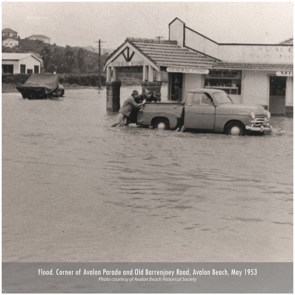
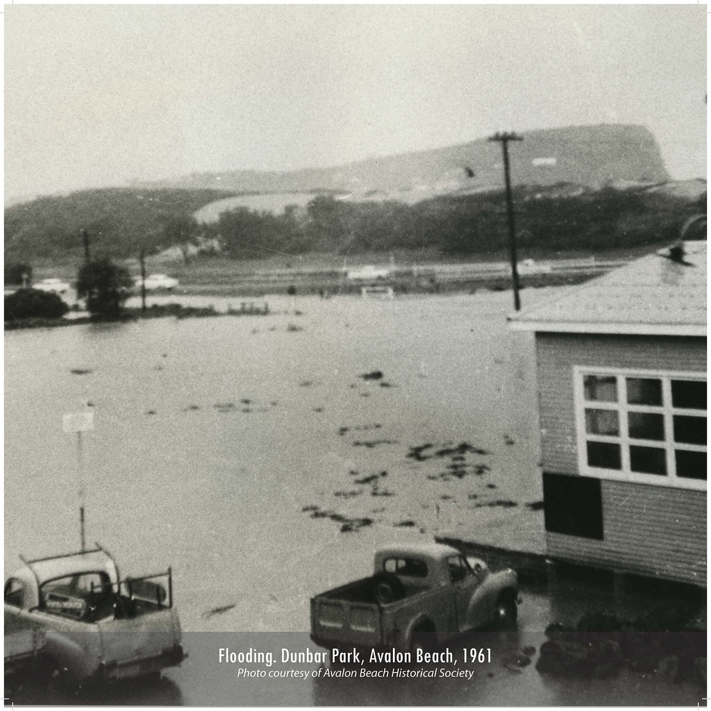
These photos, taken in May 1974 by John Stone, shows Old Barrenjoey Rd in flood.
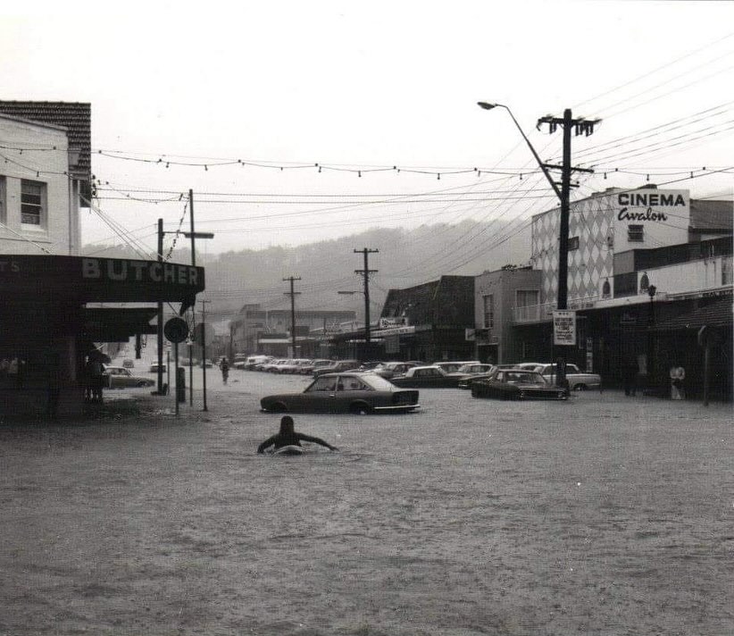
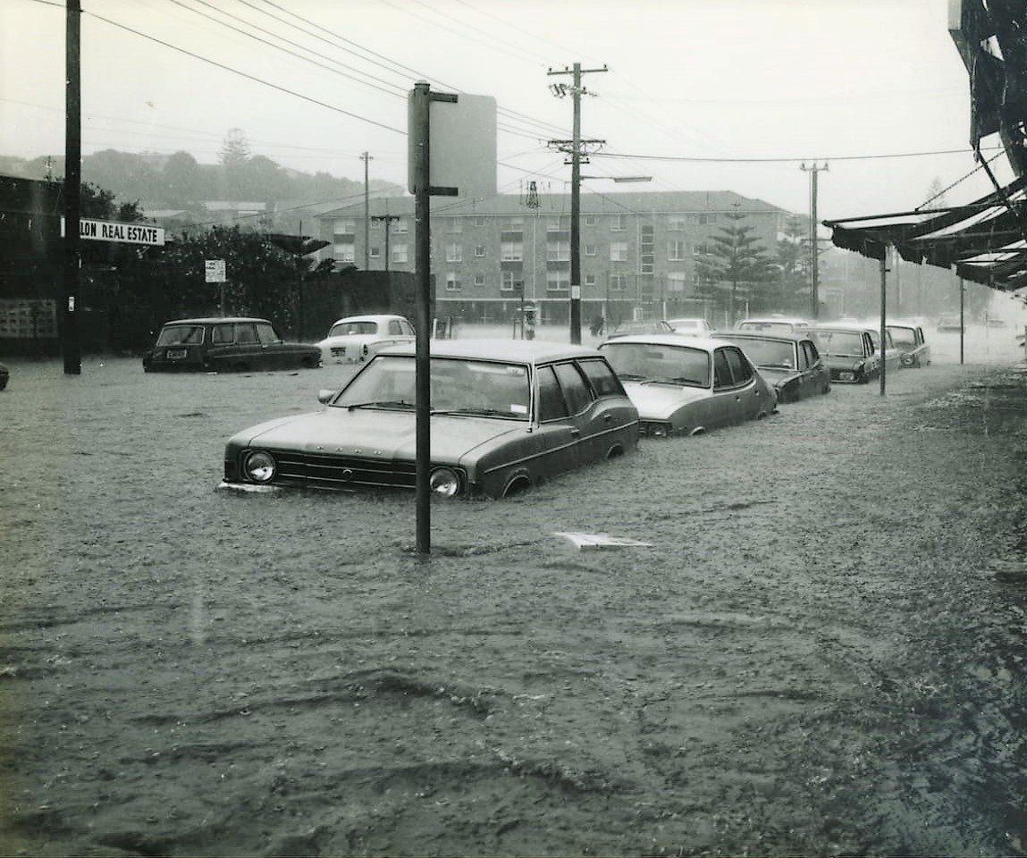
Photos courtesy John Stone and ABHS

Giles Stoddart of Avalon Honey:
I lost two of my colonies of bees when Careel Creek flooded in March 2022 during heavy rains and a king tide that meant there was nowhere for the rain to go except into people’s gardens and houses. I have a couple in North Avalon that host hives for me in their back garden, which backs on to Careel Creek. We had agreed on a location for the bees which was away from the house, and unfortunately the garden flooded very quickly before I could get there to move the hives. I was devastated and I tried to save the colony, but despite many thousands of bee surviving the flood and me giving them a new dry home with food, they never really became strong enough to survive the cooler Winter weather.
Avalon Honey's Giles trying to save his bees:
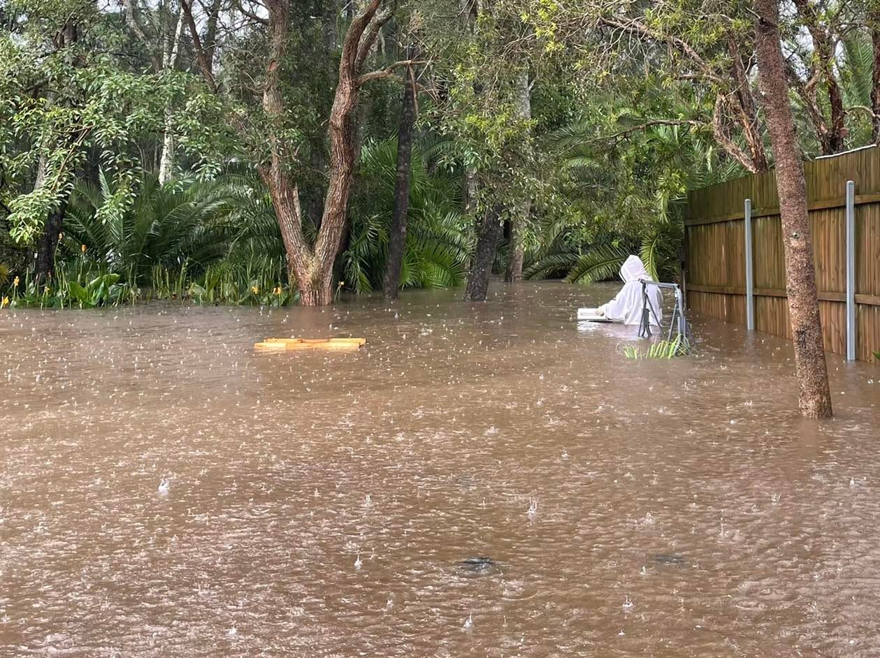
In May 2024 the valley of Avalon and Bilgola Plateau has been reminded this week that it was once a marshy floodplain called 'Priests' Flat' alongside the beach from Kamikazee corner to the mangroves of Careel Bay and that even though those water channels may now be funnelled into concrete pipes, they may still reappear during prolonged downpours of rain.
The NSW HRLV provides under Volume 4828, Folio 108 from when Angophora Reserve was handed to the community by A J Small - note the marked water courses, or creeks::
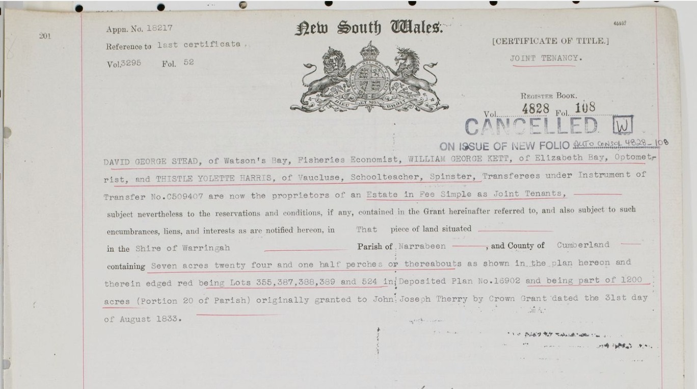
%20Vol%20Fol%204828-108.png?timestamp=1659822451523)
In February 1931 the formalisation of the dedicating the Bilgola Plateau parks from the same gentleman is recorded in Vol-Fol 4469-13, over 5 acres all up, which included some of the well-known Bilgola Plateau parks:
.jpg?timestamp=1714593544979)
.jpg?timestamp=1714594261697)
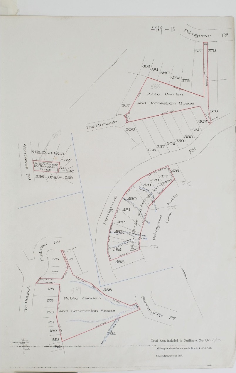
Note the creeks threading through these parks - the same is in the landscape at Angophora Reserve and Hudson Park (dedicated later as a public reserve, in 1957) during this era, as shown when that was formally gifted by A J Small and had the Wildlife Presrevation Society as Trustees, and in Dunbar Park, when that was gifted as well:
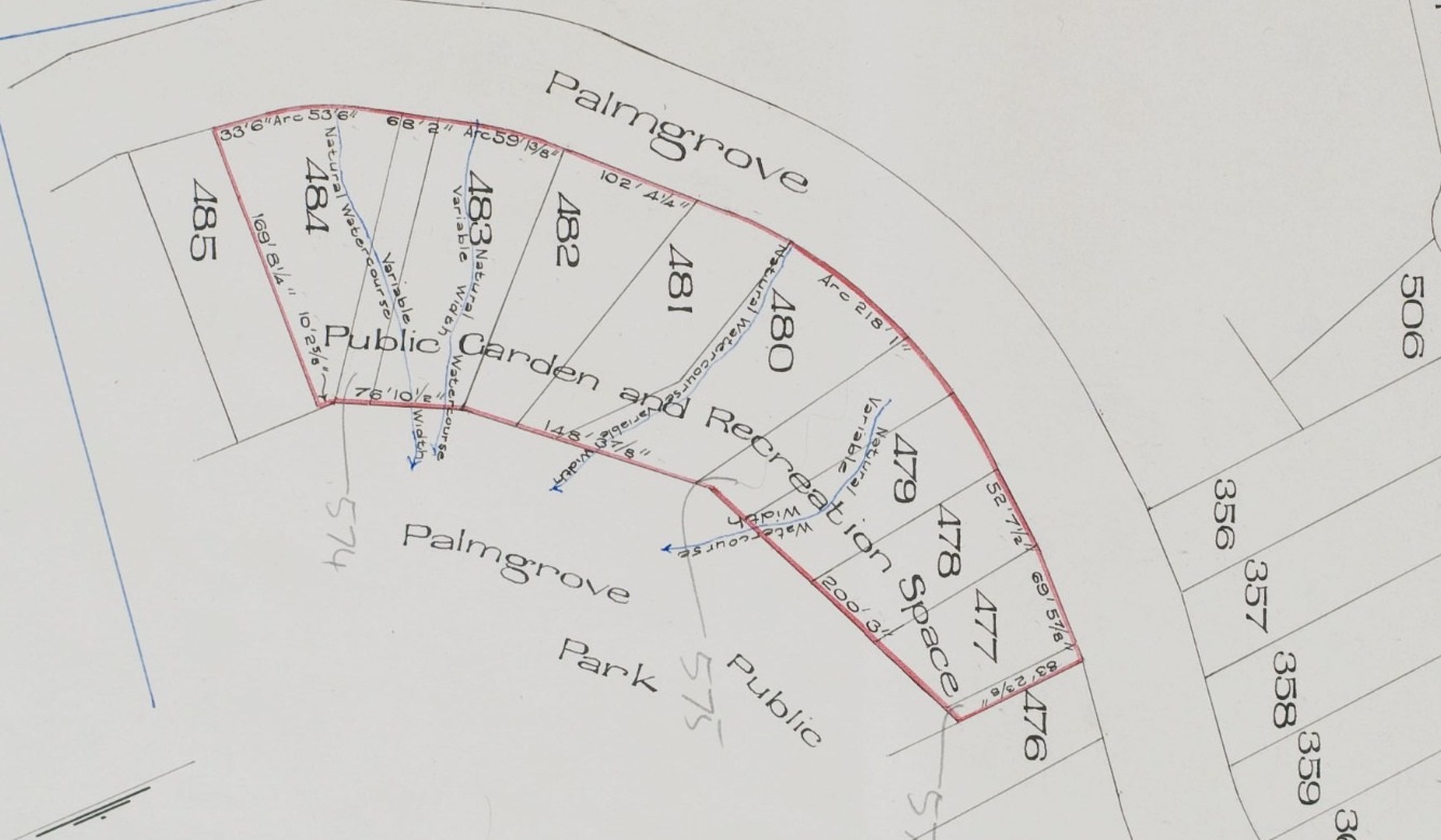
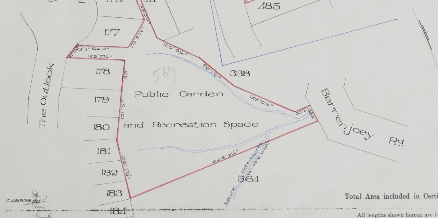
References - Extras
- TROVE - National Library of Australia
- Geoff Searl OAM, President Avalon Beach Historical Society
- The Historical Land Records Viewer (HLRV)
- The Mitchell Library, State Library of Australia
- Warringah Shire Council Minutes of Meetings Archive
- NSW Planning Portal Spatial Viewer - Crown Lands Aerials
- The Roads and Tracks Of Yesterday: How The Avalon Beach Subdivisions Changed The Green Valley Tracks
- Careel Head Road Shops and the Bangalley- Burrowong Creeks: Some History
- Grand Old Tree Of Angophora Reserve Falls Back To The Earth
- Avalon Beach This Week: A Place Of A Bursting Main, Flooding Drains + Falling Boulders - May 2024
- John Collins of Avalon
- My Holiday by Charles de Boos – 1861
- Clareville Public Wharf: 1885 to 1935 - Some History
- Careel Bay Playing Fields Reserve - Including Hitchcock Park: Birds, Boots & Beauty (History page)
- Avalon's 'Telford' Road to have signage about its Heritage
- John W. Stone - Profile interview, July 2016
- Careel Bay Jetty-Wharf-Boatshed
- NSW Government - Historical, Aerial and Satellite Imagery
- Stokes Point Careel Bay: The Shift From Warner's Hut In 1813 To Finisterre In 1924; 1934 Additions Probably Designed By Australia's First Female Architect, Beatrice (Bea) May Hutton - A Pittwater Rendezvous Site For Royal Sydney Yacht Squadron Members Is Still A Home With A View For Those With A Passion For Sailing
- Pittwater Roads II: Where The Streets Have Your Name - Avalon Beach
- Pittwater Roads II: Where The Streets Have Your Name - Careel Bay
- Pittwater Roads II: Where the Streets Have Your Name - Whale Beach
Primary Application - Harley Usill Mackenzie & John George Cousins situated on the road from Manly to Barrenjoey & Careel Creek at the South Head of Broken Bay & Hole-in-Wall on the South Pacific Ocean Shire Warringah Parish Narrabeen Volume 2560 Folio 190 (Certificate of Title dated March 16, 1915) . Contents Date Range; 12-11-1912 to 16-03-1915 – and then split to Vol-Fol: 3329-160 (Certificate of Title dated June 22 1922 - which includes by then Tasman road as Section 2) as they both pass away and the estate handles real estate transactions/liquidation of joint assets
1922 flyer (for April 1 on site land sales) and map shows a creek (called a ‘natural watercourse’) on Marine parade and going through lots 7, 8 and 15 in Section 2 down towards current day Barrenjoey high school site and north Avalon Beach dunes.
Volume 2560 Folio 190 (from 1912 onwards - sales commence in Certificates of Title registration from March 1915):
.png?timestamp=1778034993238)
.jpeg?timestamp=1778035077904)
.jpeg?timestamp=1778035176566)
Note the above shows the Recreation Reserve at North Avalon Beach and the road that goes further west
.jpeg?timestamp=1778035240286)
.jpeg?timestamp=1778035396238)
.jpeg?timestamp=1778035460429)
.jpeg?timestamp=1778035543726)
.jpeg?timestamp=1778035590453)
.jpeg?timestamp=1778035653503)
.jpeg?timestamp=1778035701510)
.jpeg?timestamp=1778035737083)
.jpeg?timestamp=1778035781743)
.jpeg?timestamp=1778035824403)
.jpeg?timestamp=1778035863459)
.jpeg?timestamp=1778035909772)
.jpeg?timestamp=1778035944913)
.jpeg?timestamp=1778035984091)
.jpeg?timestamp=1778036019696)
.jpeg?timestamp=1778036070184)
Volume – folio 3945- 73:
Careel Bay Ocean Estate North Avalon Vol-Fol 3329-160, from June 1922:
.jpg?timestamp=1778033338983)
.jpg?timestamp=1778033368600)
.jpg?timestamp=1778033432811)
.jpg?timestamp=1778033523129)
.jpg?timestamp=1778033553495)
.jpg?timestamp=1778033592161)
.jpg?timestamp=1778033630113)
.jpg?timestamp=1778033662296)
.jpg?timestamp=1778033728082)
.jpg?timestamp=1778033755782)
.jpg?timestamp=1778033795588)
.jpg?timestamp=1778033827972)
.jpg?timestamp=1778033855005)
.jpg?timestamp=1778033905265)
Vol-Fol 3945-73 is 5 acres of Bangalley Headland bush going to Warringah Council – Certificate of Title for this registered on December 8th 1926:
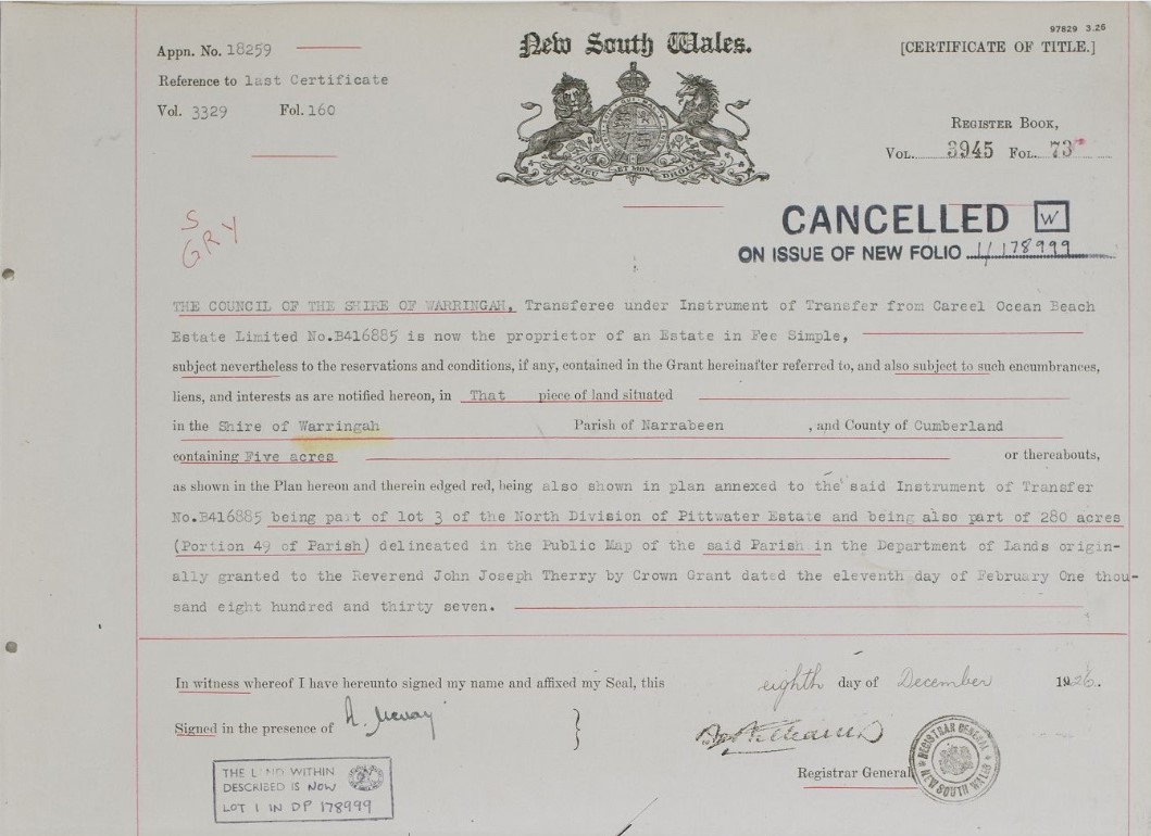
.jpg?timestamp=1777681838950)
In Vol-Fol 4337-116 is the 10 acres that goes to Arthur Jabez Small in 1926 and then his children when he passes away, in 1955:
.jpg?timestamp=1778034318407)
.jpg?timestamp=1778034363255)
.jpg?timestamp=1778034433889)
.jpg?timestamp=1778034499507)
Vol-Fol 2840-242 8 acres (part of Lots 3 and 4) alongside Careel Creek to John Daniel Fitzgerald on May 1st 1918 – current Catalina Cres and High School site. Annie Matilda Hill of Darling Point becomes co-owner on August 6th 1919 and sells to Joseph Thompson of Pittwater on May 4th 1921, and later to Arthur Jabez Small in 1929:
.jpg?timestamp=1778034624365)
.jpg?timestamp=1778034671737)
.jpg?timestamp=1778034787813)
Primary Application; PA 20950. Title: Primary Application - Emily Darvall & Florence Maud Callaghan 8 acres 24 1/2 perches at junction of roads from Manly to Careel Bay & to Barrenjoey in Shire Warringah Parish Narrabeen County Cumberland Volume 3108 Folios 86 & 87 – Lot 9. Contents Date Range: 19-06-1917 to 09-10-1920
.jpg?timestamp=1778036286960)
.jpg?timestamp=1778036326316)
They sell to Coast Lands Ltd in March 1922 and it becomes Vol-Fol:3292-204, which shows on the Certificate of Title a dam still in place on Careel Creek:
.jpg?timestamp=1778036383441)
.jpg?timestamp=1778036511435)
.jpg?timestamp=1778036561409)
.jpg?timestamp=1778036645856)
.jpg?timestamp=1778036681418)
.jpg?timestamp=1778036717722)
.jpg?timestamp=1778036749974)
.jpg?timestamp=1778036783178)
The Minutes of the Warringah Shire Council Meeting of 27th October,1924 state ''The President verbally reported having interviewed Mr. James Young and submitted a letter from Mr. Young, offering to sell his 10 ¾ acres at Careel Bay fronting Barrenjoey Road for £700 on terms, namely, £50 deposit, and the balance in annual instalments of £100 each with interest at 6 ½ % on unpaid purchase money. It was resolved, - (Crs. Hewitt, Hitchcock) That the offer be accepted and the terms approved, but that the President endeavour to arrange for a smaller deposit. ''
This was formalised in 1926: Volume 3,847, folio 56 shows the land James Young and Robert Browning (Palm Beach Land Co - follow on from Barrenjoey Land Co.) sold to the then council.
Volume 3,847, folio 56:
The Certificate of Title above also shows part of this was resumed in 1936 for roadworks - and this was when the route of the Barrenjoey road was changed as well as being where and when the Careel Creek road bridge and concrete drainage pipe was placed with works completed on March 10 1938 - this concrete drainway/road-bridge is still in place:
'Careel Creek looking south' 10.3.1938 - also new section of Barrenjoey Road being built - Item: FL3663714, courtesy NSW Records and Archives
Same drain - May 2025 (during investigation works for upcoming Pittwater creeks history pages).
Crown Land Aerial Section, showing this side of George street/Careel Creek with the 'Telford' road circled in red (old route of Barrenjoey road) marked in red. Dated 5.1.1951
Worth noting from the same council's minutes of meetings is how the changes occurred and that triangular piece of land where the North Avalon bus stop is was formed:
Main Roads Department, 16/6/37, forwarding for Council's information, copy of plan shoving the portion of Hitchcock Park Careel Bay, resumed for main road purposes. Resolved, Hitchcock' That the Department be asked to beautify the small triangular-cornered piece severed from the park by the deviation of the road. (Crs. Hitchcock, Ross)
That triangular cornered piece at corner of Barrenjoey road and North Avalon Road - Bangalley Way is the carriageway seen at the front of the first photo - See History page: Careel Bay Playing Fields Reserve - Including Hitchcock Park: Birds, Boots & Beauty
Previous Vol-Fol 3723-65 (1925 – Henry Brisbane Swan, of Balmain, Timber Merchant and Alfred George Crump of Rockdale, retired House Decorator) granted to Henry Gaskin on July 6th 1833 – Certificate of Title registered May 6th 1925, and is 5 acres, 4 roads and 65 perches all up, on Bayview, Riverview, Shore Brace and Queens Avenue, as well as 8 acres and O perches on George street and to Barrenjoey road – Careel Creek shown at side of BJ road: this whole is sold to William David Johnston of Manly, Draftsman on June 22nd 1927, who proceeds to sell off as Lots. Previous is primary application 24765 which is the 50 acres granted to Thomas Warner, the 50 acres granted to Henry Gaskin and the 1200 acres granted to John Joseph Therry. Mr. Johnston had already been advertising the same the year before.
Vol-Fol 3723-65:
.jpg?timestamp=1770132790159)
.jpg?timestamp=1770132854193)
.jpg?timestamp=1770132898103)
.jpg?timestamp=1770132953881)
No. 33,683. Catherine Georgina McPhillimy, 2 a. 1 r, 16 p., lot 8, sec. C. Stokes Point Subdn., Bayview rd., and on Careel Bay, Narrabeen. NOTICE UNDER REAL PROPERTY ACT. (1939, April 6). Government Gazette of the State of New South Wales (Sydney, NSW : 1901 - 2001), p. 2037. Retrieved from http://nla.gov.au/nla.news-article222063158
PA 33683- Title; Primary Application - Catherine Georgina McPhillimy 2 acres 1 rood 16 perches in Bayview Road & on Careel Bay in Parish Narrabeen County Cumberland Shire Warringah Volume 5062 Folio 213 Contents Date Range: 30-08-1938 to 26-08-1941 – this is transferred to Catherine Georgina Hopper, wife of John Byess Hopper of Careel Bay, Bank Officer, on May 24th, 1954. They sell Lot 1 of this subdivided acreage to Ronald James Rankin on august 31st 1956 (Vol-Fol: 7267-59), Lots 2 and 3 to Edward Robert Turner and Merle Ida Turner on June 18, 1957 (Vol-Fol: not entered) and Lots 4,5,6 and 7 to Harold William Woods (Vol-Fol: 7383-142/143/144/145):
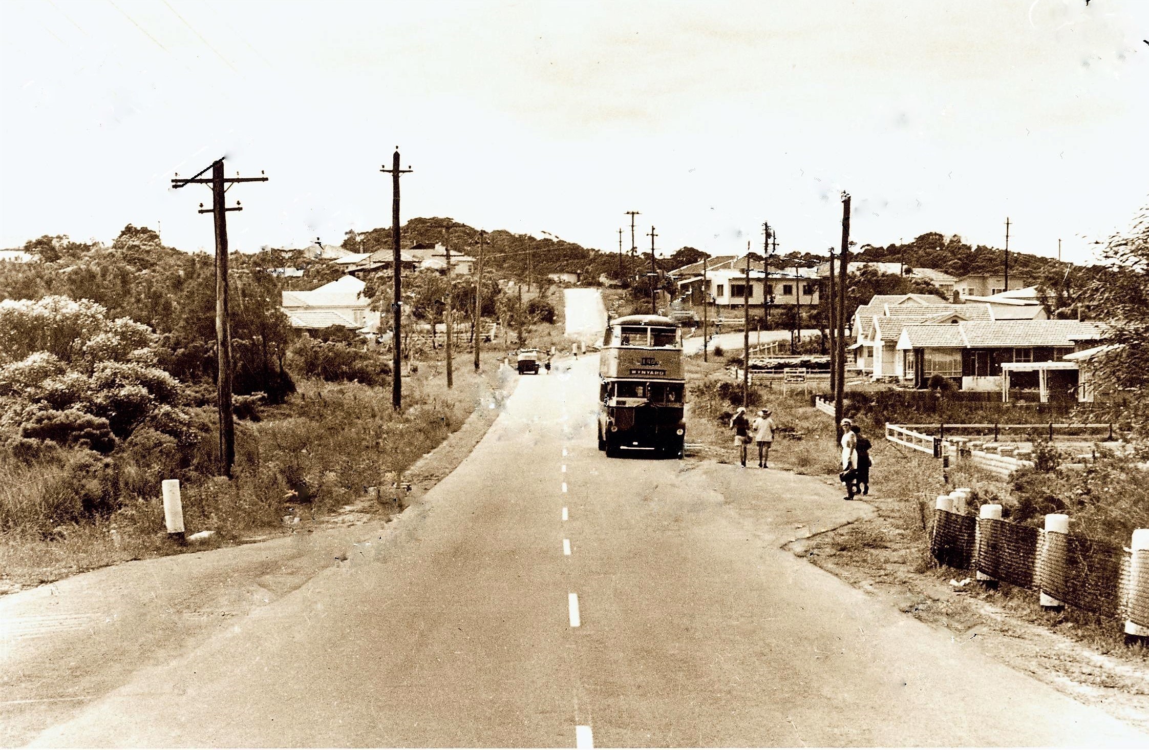
Barrenjoey road looking north - George street on the right straight ahead, circa 1950-1955
IN DIVORCE.
(Before the Judge in Divorce, Mr. Justice Boyce.)
DECREES ABSOLUTE.
Decrees absolute were pronounced in the following suits:-… Stanley James McPhillimy v Catherine Georgina McPhillimy,… IN DIVORCE. (1937, November 24). The Sydney Morning Herald (NSW : 1842 - 1954), p. 10. Retrieved from http://nla.gov.au/nla.news-article17398155
WIFE'S FIGHT FOR HUSBAND'S ESTATE
Whether the estate of a former director of Malleys Ltd. should be shared equally by his wife and a woman with whom he had been living was argued before Mr. Justice Nicholas in the Equity Court today.
'THE' director, Clyde Malley, Careel Bay, via Newport, left an estate worth £49,859 on his death in December, 1943. He provided that most of the estate should go into a fund to be shared equally by his wife and Mrs. Catherine Georgina McPhillimy. Today the wife, Mrs. Annie Cordery Malley, 200 Spit Rd„ Mosman, asked Mr. Justice Nicholas to grant her the whole of the income from her late husband's estate.
In an affidavit, Mrs. Malley said her husband deserted her in 1937, and went to live with Mrs. McPhillimy, who at the time was conducting a beauty parlor under the name of "Georgina." in St. James Building, Elizabeth St. Mr. M. F. Hardy (for the Perpetual Trustee Company, executor of the estate) submitted that no further demands should be made by Mrs. Malley, who had capital valued at £14,382 and a home worth £2100. "Mrs. Malley's income, apart from what she derives from the estate, is £567 a year," he said. Mr. E. J. Hooke (for Mrs. Malley); My client's income from the estate should be a guaranteed sum. The judge made an order granting Mrs. Malley £1000 a year or half the income from the estate, whichever was the greater. WIFE'S FIGHT FOR HUSBAND'S ESTATE (1945, July 27). Daily Mirror (Sydney, NSW : 1941 - 1955), p. 3 (Late Final Extra). Retrieved from http://nla.gov.au/nla.news-article272496496
An advertorial for same:
AVALON-CAREEL
THREE ESTATES AT ONCE
Three separate estates at Avalon and Careel Bay are to be sold by Messrs. Peach Bros, (in conjunction with Clubb and Hibble, and Laws and Flowerdew), next Monday.
They are linked together by the title of Johnston Estates, but are separate, and strung across the Barrenjoey Peninsula, between Avalon and Pittwater. There are 14 allotments in the section situated on the narrow strip which juts Into Pittwater and terminates at Stripe Head. They overlook the broad sheet of water, and are Within 100 feet of it. The second wayside estate has actual water frontages to Careel Bay. There are eight of these, with big depths of nearly 400 feet, which gives them other frontages to Bayview-road and Queen's-avenue as well. The Avalon offering is situated slightly north of the beach, on a rising slope which gives wonderful views across Pittwater, as well as down the southern coastline. This is the bigger section, its 34 allotments having frontages of from 40 to over 100 feet. Deposits for water frontages are £10. per lot, and for others £5 per lot. AVALON-CAREEL (1926, December 24). The Sun (Sydney, NSW : 1910 - 1954), p. 2 (FINAL EXTRA). Retrieved from http://nla.gov.au/nla.news-article224119171
On the above you can see the placement of the homes of the Monckton, Elliott and Howard lands. Mr. Howard was married to a daughter of the same Frederick Smith who bought a farm lot and other land holdings in May 1881- specifically lots 5 and 6, section A, 3 acres 1 rood 21 perches and a Farm; lot 4, 65 acres 0 roods 32 perches, paying L247 15s 2d for the 65 acre farm
HOWARD — SMITH.— April 25th. at St. Augustine's Church, Neutral Bay, by the Rev. G. North Ash, Harold T. Howard, third son of W. H. Howard, of North Sydney, to Mary T. J. Smith, youngest daughter of Frederick Smith, of "Alma," Belmont Rd., Mosman. Family Notices (1900, May 12). The Daily Telegraph (Sydney, NSW : 1883 - 1930), p. 1. Retrieved from http://nla.gov.au/nla.news-article237306577

Frederick Smith, Careel Bay, Pittwater - REGISTRATION OF BRANDS ACT OF 1866. (1886, January 9). New South Wales Government Gazette (Sydney, NSW : 1832 - 1900), p. 171. Retrieved from http://nla.gov.au/nla.news-article221650296
When Frederick Smith passed away Mr. Howard was placed in charge of part of his Careel Bay land holdings:
ESTATE VALUED AT £17,159.
LATE FREDERICK SMITH'S WILL
The net value of the estate of the late Frederick Smith, who resided at Alma, Belmont-road, Mosman, has been sworn for probate purposes at £17,159. By his will dated October 26, 1904, testator appointed his sons Sidney, Arthur, and Frederick, and his daughter Frances, executors, executrix, and trustees of his estate.
He bequeathed the furniture, ornaments, plate, and effects at Alma to his daughter Frances, which furniture and effects were purchased by her with her own money. He also gave his pony phaeton, harness, and all other articles of a similar nature to his daughter Frances. The house occupied by his son Frederick in Chuter-street, North Sydney, testator left to Frederick upon trust to receive the benefits, rents, or profits from it until his death, when it goes to the children. If there are no children the house becomes part of testator's residuary estate. He left the property at the corner of Alexander and Atchison streets, North Sydney, upon trust to his son Francis, and the property in Glover-street upon trust to his son Arthur for life, both upon the same terms as that provided in the case of the be quest to the son Frederick.
He left certain property at Careel Bay, Pittwater, to his son-in-law, Harold Trotman Howard, absolutely, and the remainder of his Careel Bay property to all of testator's children as joint tenants.
He left £50 to the North Shore Hospital, an annuity of £200 to his daughter Frances, an annuity of £150 to his friend Rosalie Grigg, and an annuity of £50 to his daughter Isabella, now Isabella Reed. The residue of real and personal estate to be held in trust for the children after due provision has been made for the paying off of certain mortgages. In a codicil dated March 31, 1908, testator revoked his former provision In the matter, of the trustees, executors, and executrix, and appointed In their place his son-in-law, Harold Trotman Howard, in conjunction with testator's son Arthur and daughter Frances. He further provided that in the event of Rosalie Grigg predeceasing his daughter Frances the annuity of £150 should go to Frances, while the annuity of £50 payable to Isabella Reed is to go to the daughter May Howard in the event of the annuitant predeceasing May Howard. ESTATE VALUED AT £17,159. (1914, July 7). The Sun (Sydney, NSW : 1910 - 1954), p. 1 (FINAL EXTRA). Retrieved from http://nla.gov.au/nla.news-article229855290
LATE MR. FREDERICK SMITH.
Old North Sydney resident.
The late Mr, Frederick Smith, who died at his residence, Belmont-road, Mosman, on Wednesday, was one of the oldest identities of North Sydney. He had reached his 83rd year, and the greater part of this long life was spent in that district, where, until recently, he was a familiar figure at most public gatherings. His interest in local office was shown in his participation in public duties. Prior to the amalgamation of the old municipalities of Victoria, St. Leonards, and East St. Leonards into the present North Sydney in 1890, he was Mayor and Alderman of Victoria, which was that area around M'Mahon's Point, Blue's Point, Lavender Bay, and Bay-road. In the united council, he sat for six years, then giving place to a younger man. He was one of the oldest Masons of the northern suburbs, having been Initiated into the mysteries of the Order about 50 years ago, and was associated with the first lodge established on the North Shore in 1867. He was also a foundation member of Lodge Samaritan, formed in 1874, subsequently occupying the chair. His interest in the craft was very keen, and fit the meeting of the latter lodge in April last, he was presented with a framed photograph of himself, to mark the members' appreciation of his services. As a member of the committee of the North Shore Hospital, he did good work, besides taking an interest in charitable movements generally. The funeral took, place at Gore-hill Cemetery yesterday afternoon, in the presence of a large and representative gathering. The burial service' was read by tile Rev. G, North Ash, and following It, extracts from the Masonic ritual were lead by Wor. Bro. Hall (Lodge Samaritan), accompanied by the usual riles of the Order. The chief mourners were:— Messrs. Frederick, Francis, Sidney, and Arthur Smith (sons), Howard (son-in-law), and amongst the others present were Ald. Anderson (Mayor of North Sydney), and other representatives of the council, Captain Green (representing the North Sydney Orphans), Wor. Bros. V. E. Neilly (W.U.), and F. S. Murco (secretary), and officers and brethren of Lodge Samaritan, and representatives of St. Leonards. Mosman, Ku-ring-gal, Lawson, Empress of India, and other lodges. LATE MR. FREDERICK SMITH. (1914, May 15). The Daily Telegraph (Sydney, NSW : 1883 - 1930), p. 11. Retrieved from http://nla.gov.au/nla.news-article238801150
It is Mr. Howard, a Surveyor whose main address is at ''Lincoln'', Kenneth-street and Belcote-avenue, Longueville, who on August 26, 1918 has correspondence dated 8/8/18, is recorded in Warringah Shire Council records, on behalf of seven owners at Careel Bay, who is asking council to take steps to have an obstruction across old road way leading from Stokes Point to the main Careel Bay Road removed. This was Referred to the Engineer for report, and perhaps lends insight into his 1924 objections as well.
Warringah Shire Councils' Meeting of October 21st, 1918 records Russell C. Roxburgh, 17/10/18, re notice to W. H. Monckton to remove fence from road at Careel Bay and a notice to Dr. Elliott to remove fence from road at Careel Bay; Consideration was deferred-until next meeting.
On November 4th, 1918 Howard & Company, 22/10/18, are submitting a plan of a proposed subdivision of land at junction of Careel Bay Road and Barrenjoey Road. It was Resolved, on the motion of Councillor Atkin, seconded by Councillor Sturman, that the plan be approved.
About Emily Darvall and Florence Maud Callaghan
Emily Sarah Darvall - Date of Death 08/06/1937, Granted on 06/09/1937
Born; MCDONALD EMILY S 4152/1865 to WILLIAM and MARGARET registered at CONCORD.
Florence Maud Callaghan - Date of Death 30/07/1949, Granted on 02/12/1965
PAYMENTS OUT OF CAPITAL. A CHANGE OF TRUSTEES.
The suit of Darvall v, Quinlan came before the Court by way of a motion for a decree removing Henry Gregory Quinlan, Insurance broker, Grace M Donnell, widowed daughter of the testator and Charles Hepburn, patent agent, from their positions as executors and trustees under the will of the late William M'DonaId, of Inverary, Concord, who died on June 11, 1901. Mr. Parker, for Mr. Loxton (instructed by Mr. H. Salwey), appeared for Ena Gertrude Darvall, an infant (by her next friend, Gerald Ashley Darvall), plaintiff; Mr. Harvey (instructed by Messrs. Stephen, Jaques, and Stephen), for the defendants, Henry Gregory Quinlan and Charles Hepburn; Mr. Salwey for the defendants Grace M Donnell, Emily Sarah Darvall, Arthur M'Donald, and Evelina Barnard; Mr. M'Laurin (Instructed by Messrs. Minter, Simpson, and Co.), tor the defendants, Annie Redgate, Cecil Fitzpatrick, and Eileen Ryan; and Mr. Innes (Instructed by Mr. H. B. Primrose), for the defendants Stanley M'Donnell, Wilfred M'Donnell, and Inez M'Donnell.
A daughter of the testator, Emily Sarah M'Donald, married in September, 1904, Gerald Ashley Darvall, and they had as issue the plaintiff Ena Gertrude Darvall, who was born in August, 1905. Plaintiff charged that the active management of the estate had been left almost entirely to Henry Gregory Quinlan, and that the other two trustees and executors had exercised no control or supervision over him, and that no proper books or accounts had been kept to show what moneys had boon received in respect of capital and Income respectively, and what disbursements had been made or were properly chargeable against capital and income respectively. Plaintiff further charged that Quinlan and Hepburn had out of the estate wrongfully paid away to their co-defendant, Grace M'Donnell, for her own use, or wrongfully allowed her to receive and appropriate to her own use, large sums of money in respect of capital greatly in excess of the amount to which she was entitled under the will in respect of income, and had kept no proper records of such payments. or receipts, and had taken no security for repayments to the estate. Plaintiff further charged that the three executors and trustees, or one or other of them, had wrongfully paid away to the defendant Emily Sarah Darvall, large sums of money out of capital, and in excess of the amount to which she was entitled' under the will, and had allowed her to receive the same in ignorance that such payments were being made out of capital, and had kept no proper records of such payments. Plaintiff submitted that It was for the benefit of all persons beneficially interested under the will that the defendants, Henry Gregory Quinlan, Grace M'Donnell, and Charles Hepburn, be removed from their position as trustees of the estate, and that some other persons be appointed, in their stead. His Honor, after argument, made an order in terms of minutes filed in court. The defendants, ,H. G. Quinlan, Grace M'Donnell, and Charles Hepburn consented to retire from the position as trustees, and to have appointed in their place John William M'Donald and Frank M'Donald. It was declared that. there had been wrongfully paid out of capital by the three defendant trustees the sum of £1620 6s 8d, and that the defendant trustees were indebted to the trust estate in this sum, which it was ordered should he. paid to Frank M'Donald without prejudice to the right, If any, of Quinlan and Hepburn; to recover from the defendants, Grace M'Donnell and Emily Sarah Darvall respectively, any portion of moneys which they or either of them might have to pay, and without prejudice to the question whether such alleged right, if any, of the defendants Quinlan and Hepburn had been abandoned. EQUITY COURT. (1908, December 15). The Sydney Morning Herald (NSW : 1842 - 1954), p. 5. Retrieved from http://nla.gov.au/nla.news-article15014145
The engagement is just announced of Miss Emily M'Donald, daughter of the late Mr. and Mrs. William M'Donald. 'Inverary.' Concord, and Mr. Gerald Darvall of Sydney. WOMANS PAGE (1904, August 20). Freeman's Journal (Sydney, NSW : 1850 - 1932), p. 29. Retrieved from http://nla.gov.au/nla.news-article111306500
M'DONALD.—June 20th at her late residence, "Inverary," Concord, Margaret, the dearly beloved wife of William M'Donald, senr., aged 70 years. R.I.P. Family Notices (1902, July 5). Freeman's Journal (Sydney, NSW : 1850 - 1932), p. 22. Retrieved from http://nla.gov.au/nla.news-article111067491
THE Late Mrs. Margaret M' Donald, Concord.
A well-known and highly respected citizen in the person of Mrs M 'Donald, wife of Mr. William M’Donald, Sen., passed away at her residence 'Inverary,' Concord, on Saturday last. Although ailing for some time past her death was somewhat unexpected.. The late Mrs. M'Donald was a native of Roseborough, Tipperary and was 71 years of age at the time of her death. Mrs. M'Donald came to this colony in 1848, and was married for 54 years. Her remains were interred at Rookwood on Sunday afternoon last, the funeral being attended by a large number of her friends. The chief mourners were: Mr. W. M 'Donald, Sen. (husband), Messrs. J. M'Donald, 'SP. M'Donald, W. M 'Donald, A, M 'Donald (sons), F. M 'Donald, jun,, W. McDonald, jun., H. M 'Donald (grandsons), J Frewin, W. Walshe (cousins), Hon. T. M. Slattery, M.L C, Major Freehill, Messrs J. Ahearn, J. Baxter, J. Baxter, jun., J. Hollingdale G. F. and J. Williamson, C. J. M'Donnell, H. Q Quinlan, Arthur Levy, D. Curbin, P. R Larkin. W. Bradley, H. Moyse, C. Hepburn, H. Tress, G. O'Keeffe, C. Benson. J. Jackson, 10. Evans, W. Monie, P. K. White, J Gugoho Ryan, 10. M'Namarra, A. and W Pearson, P. J. Hourigan, B. Gaffney, J. V. Casey, M. Canty, J. Woods, J. Murphy and H. Doly. The Rev. Father P Byrne, P.P., and Rev. Father Meagher officiated at the grave. — RI.P. The Late Mrs. Margaret M'Donald, Concord. (1902, June 28). The Catholic Press (Sydney, NSW : 1895 - 1942), p. 15. Retrieved from http://nla.gov.au/nla.news-article104413172
McDONALD-June 11, at Glenara, Medlow Bath, William McDonald, Esq, J.P., of Inverary, Parramatta and Concord roads. Concord, In his 79th year. By request, no flowers. Family Notices (1904, June 13). The Sydney Morning Herald (NSW : 1842 - 1954), p. 6. Retrieved from http://nla.gov.au/nla.news-article14652866
M'.DONALD.—June 11, at Medlow, William M'Donald, sen. late of Invermay, Concord, aged 77. Family Notices (1904, June 15). Australian Town and Country Journal (Sydney, NSW : 1870 - 1919), p. 18. Retrieved from http://nla.gov.au/nla.news-article71510750
NSW BDM’s: MCDONALD WILLIAM 5721/1904 WILLIAM KATOOMBA
MR. WILLIAM M'DONALD, J.P.
The 'head of one of Sydney's most estimable Catholic families passed away on Saturday last at his Mountain residence, 'Glenara,'' Medlow Bath, in the person of Mr. William M'Donald, J.P. Mr. M'Donald, who was in the 79th year of his age at the time of his death, took seriously ill on Thursday last, and never rallied. He was attended in his last moments by the Rev. Father St. Glair Bridge, of Katoomba, who administered the last rites of the Church. The casket containing the body was conveyed to his late residence, 'Inverary,' Parramatta and Concord roads, Concord, whence the funeral took place to the Necropolis, Rookwood, on Monday afternoon. The chief mourners included Messrs. John W., Frank, William, and Arthur (sons), William, Frank, Herbert, and Arthur M'Donald, and Stanley and Wilfred M'Donnell (grandsons), and R. N. Bull and Walter Redgate (sons-in-law). There was a representative gathering at the funeral, among those present being the Hon. T. M. Slattery, M.L.C.. Mr. F. B. Freehill Mr. John Ahern, Mr. John. Bacuv, Mr. HZ G. Quinlan, Mr. P. R. Larkin, Mr. W Monie, senior, Mr. W. Monie, junior, Mr. John Daly. Mr. C. M. Benson, Mr. George F. Williamson. Mr. P. Burke. Mr. William Walsh, Mr. T. Lacy. Mr. Byrnes; .iunior. Mr. Turnbull. Mr. J. Balkin, Mr. H. Moyw. and many MoMiers. The ?lev. i ;ni-'i' i'-.b'Rollly .(Rookwood) officiated at the grave. For the last few years deceased has resided at his Mountain residence, previous to which he had enjoyed many years of retirement from active business pursuits at his Concord residence. Although in a position of independence, he .took no part in public life, ibut preferred to enjoy life apart from any public Ambition. He was so long .identified with Sydney that his death severs .another link with the city's' old-time, as well as removing another of the early Catholic citizens of Sydney. MR. WILLIAM M'DONALD, J.P. (1904, June 18). Freeman's Journal (Sydney, NSW : 1850 - 1932), p. 19. Retrieved from http://nla.gov.au/nla.news-article111300705
Gerald Ashley Darvall: Name of Firm: HAYES & DARVALL, Nature of Business: Real Estate Agents, Place of Business: 82 Pitt Street Sydney, Person Carrying on Business: HAYES, Lyell White; DARVALL, Gerald Ashley. Additional People in Business: MARTIN, William Henry; DARVALL, Gerald Ashley; RUSSELL, Frederick Joseph. Date of Registration: 28 Jan 1920. Name of Firm: CHAMBERS & WALKER. Nature of Business: Auctioneers Stock Station & Property Salesmen. Place of Business: Various. Person Carrying on Business: LYNCH, George Francis; WALKER, James John. Additional People in Business: CHAMBERS, William Leigh; DARVALL, Gerald Ashley; COX, Norman Thomas. Date of Registration: 16 Aug 1912
Mr. Gerald Ashley Darvall, who has been a partner in the firm of Messrs. Chambers and Walker, auctioneers, etc , of Moss Vale and Sydney, has retired from the business, which in future will be carried on by the two other partners Messrs. J. J. Walker and N. T. Cox. Local and General. (1918, July 20). The Scrutineer and Berrima District Press (NSW : 1892 - 1948), p. 2. Retrieved from http://nla.gov.au/nla.news-article132968169
Florence Maud Callaghan Date of Death 30/07/1949, Granted on 02/12/1965. Florence Maud Callaghan - 1874 to 1949 – born at Wagga Wagga to Matthew Nicholas CALLAGHAN (1828 - 1890) and Mary Ann RUDD (1831 - 1882)
Matthew was b. 1828 at Campbelltown, New South Wales, Australia, m. 27 Nov 1850 Mary Ann RUDD (1831 - 1882) at Campbelltown, New South Wales, Australia, d. 17 Aug 1890 at Wagga Wagga, New South Wales, Australia aged 62
John Daniel (Jack) Fitzgerald (1862-1922), compositor, journalist, barrister and politician, was born on 11 June 1862 at Shellharbour, New South Wales, son of John Daniel Fitzgerald, schoolteacher, and his wife Mary Ann, née Cullen, both from Limerick, Ireland. He was educated at the local public school, then at Fort Street and St Mary's Cathedral schools, Sydney. Apprenticed as a compositor at Bathurst, by 1885 he was working on the Evening News in Sydney and active in trade unionism and radical politics. He joined the Typographical Association, was president in 1887-88 and its delegate on the Trades and Labor Council, where he was elected to the executive and became a leading exponent of advanced political and social reforms. He was a member of the Socialist League and the founder of a republican league. An insatiable reader of progressive literature, he was a keen student of British socialism and trade unionism. In 1891 he was a foundation councillor of the Womanhood Suffrage League.
Jack Fitzgerald was in the forefront of the maritime strike of 1890. In September he went at his own expense to England on behalf of the Labor Defence Council to publicize the dispute; he also wanted to 'foster the spirit of kinship which has so recently developed between the old world workers and the new', following the Australian donation of about £38,000 to London dockers in their 1889 strike and his own awareness of the similarity of gross squalor in London and Sydney slums. He travelled widely, addressed many meetings and gave impetus to the 'hands across the sea' concept which, in English-speaking countries, was modulating the grim doctrine of the class war. He met prominent radicals and liberals, including Mr Gladstone, John Burns, Keir Hardie, Tom Mann, George Shipton and R. B. Cunninghame Graham; he studied municipal socialism and urban renewal in London and elsewhere, also visiting France, Germany and Italy. He later corresponded with several of his overseas friends. In March 1891 he published in the Nineteenth Century 'A reply' to H. H. Champion's attack on the leaders of the maritime strike.
Fitzgerald returned to Sydney in time to take an important part in the final stages (March) of the founding of the Labor Electoral League (Labor Party) by the T.L.C. He was one of the four party members elected for West Sydney at the June general election, and became a member of the five-man committee of advice that attempted to lead thirty-five Labor parliamentarians. A confirmed protectionist, he was not happy with the party's support of the Parkes Free Trade ministry. In October the more suitable Dibbs government took over, by which time the Labor Party was in disarray. In December a split occurred and Fitzgerald became one of the protectionist Labor members keeping Dibbs in office.
A more serious party conflict broke out in September 1892 during the Broken Hill strike: (Sir) George Reid, the new Free Trade leader, moved a simple censure motion, but would not bring the government down on a Labor amendment condemning the handling of the strike; Fitzgerald voted for the latter but, with ten other Labor protectionists, refused to support Reid's censure, and Dibbs remained in office. Of the eleven, only four, including Fitzgerald, were still regarded as belonging to the party; they were execrated by all sections of Labor and were formally expelled at a conference in November 1893. By then Fitzgerald's radicalism had acquired firmer ideological bases, influenced by the British Fabians, and by the middle-class reformism of Alfred Deakin and C. C. Kingston, with whom he corresponded. He had lost some of his trade union, Labor pragmatism and now sought social and political improvements by democratic, knowledgeable, alert and concerned professionals, operating at various levels of government.
Fitzgerald was of medium build, handsome, with a style and assurance complemented by a well-trimmed moustache and Vandyke beard. He had returned to England in 1892 and, on 26 May at Chelsea registry office, married Octavie Camille Clara Ernestine Roche: John Burns was a witness. Fitzgerald's wife was a cultivated Frenchwoman; she fostered his growing cosmopolitanism and interest in music (he played the piano), literature, art and architecture. In 1893, when registering the birth of his only child, Maria Galatea (Ara), he described himself as a painter. The same year he was a commissioner for the Chicago exhibition.
W. M. Hughes, the 'solidarity' Labor candidate, beat him at the 1894 general election. Fitzgerald lost again in 1895, at Bathurst, where he had Catholic connexions. He went back to journalism, contributed to radical papers, and edited Fairplay, the journal of the liquor trade. He worked for a time at Rockhampton, Queensland, and was editor of the Sydney Freeman's Journal in 1899-1904. In 1897 he was in London again. With the help of his brothers Tom and Dan, who had made a success of Fitzgeralds' circus (wound up in 1906), he studied law and was admitted to the New South Wales Bar on 30 April 1900. Supporting (Sir) Edmund Barton, Fitzgerald was a Federationist and contested the seat of Robertson in 1901, but lost. He was an alderman of the Sydney Municipal Council in 1900-04, and in the latter year failed as an independent to win the State seat of Belmore. In 1903 he became a member of Central Board for Old Age Pensions.
The Sydney council had not been responsive to Fitzgerald's views on the role of local government in the modernization of cities but, probably more than any other individual, he prepared public opinion for improvement in New South Wales. In 1899 he had published his Toynbee lecture, Municipal Statesmanship in Europe, What Municipal Reform has Done. He refreshed his ideas with a trip to Japan in 1903; in 1906 he stimulated discussion with Greater Sydney and Greater Newcastle; and next year 'Sydney, the cinderella of cities', in the Lone Hand, exposed some unpalatable facts. His hope that (Sir) Joseph Carruthers would be able to pass appropriate legislation was unfounded. He respected and remained loyal to Deakin, but Federal politics offered no solutions for town-planning. With the Fusion of the conservative parties under Deakin in 1909, Fitzgerald returned to the Labor Party, but was beaten by (Sir) Daniel Levy for the middle-class State seat of Darlinghurst next year, when Labor won office for the first time.
He again became active in the party and was a member of its executive in 1911-16 and vice-president in 1912. He revisited Europe in 1913 and attended the funeral of August Bebel. Fitzgerald was Labor Party president in 1915-16, marking the temporary retention of party control by the premier, W. A. Holman, and the remaining precarious influence of intellectual socialism opposed to the syndicalism and trade unionism of the 'industrialists'. He was appointed to the Legislative Council in 1915, and was vice-president of the Executive Council (until July 1919) and representative of the government in the council (until June 1918). Feeling keenly the plight of France and Belgium in World War I, and with his wife and daughter in Rome, he was a founder in 1915 of the Universal Service League, which sought total commitment to the war. With many others he was again expelled from the Labor Party in 1916 for supporting conscription.
In Holman's National government of that year Fitzgerald also became minister for public health and for local government. The conservatism of his new colleagues, his heavy work-load, his declining health, and wartime exigencies retarded his still-vital reformism, but he improved his departments and, building on the work of F. Flowers, facilitated progress in mother and child welfare and in the treatment of tuberculosis and venereal disease. He was president of the Health Society of New South Wales and founded the Society for the Prevention and Cure of Consumption. He provided effective leadership in the State campaign against the influenza pandemic in 1918-19.
On the death of J. R. Dacey in 1912, Fitzgerald had become chairman of the Housing Board; he helped to initiate and, with the aid of (Sir) John Sulman, controlled the early building of the 'garden suburb', Daceyville. In 1913 he was on the royal commission for a greater Sydney. A foundation member and vice-president of the Town Planning Association of New South Wales that year, he was chairman of the first interstate conference in Adelaide in 1917 and of the second in Brisbane next year. Against increasing difficulties—which included six months sick leave in 1917 when he visited the United States of America—he managed to work on a local government bill; passed in 1919, it remains a landmark in its field, although, in the end, it was a pale projection of Fitzgerald's ideas and aspirations. In 1919-20 he was solicitor-general and minister of justice.
For his assistance to French charities and to Frenchmen passing through Sydney, Fitzgerald was awarded the Légion d'honneur in 1919. He was close to Archbishop Kelly, especially in the war years, Secretary of the local Irish National League, after years of work for Home Rule—he kept in touch with John Redmond—he was isolated by the Dublin Easter rising in 1916. He was a trustee of the Public (State) Library of New South Wales in 1912-22. In 1915 he published The Rise of the N.S.W. Political Labor Party; in 1922, a novel, The Ring Valley; in 1923, stories of circus life, Children of the Sunlight, and next year, Studies in Australian Crime. He also chanced his arm at poetry and play-writing.
Fitzgerald died of cancer in his home at Darling Point, Sydney, on 4 July 1922 and was buried in the Catholic section of Waverley cemetery. He was survived by his daughter who, as Maria Galatea Clarke, achieved some notice in America for her singing. His estate was sworn for probate at £904. A portrait by Longstaff, his close friend, is in the Sydney Town Hall. Fitzgerald Avenue, Maroubra, is named after him. Bede Nairn, 'Fitzgerald, John Daniel (Jack) (1862–1922)', Australian Dictionary of Biography, National Centre of Biography, Australian National University, https://adb.anu.edu.au/biography/fitzgerald-john-daniel-jack-6180/text10623, published first in hardcopy 1981
Moore, May. (1919). Portrait of J.D. Fitzgerald Retrieved from http://nla.gov.au/nla.obj-134698923
Breckenridge Family
Henry Miles Breckenridge born February 16, 1875 at Forster, New South Wales, Australia, died July 07, 1941 (66) at Drummoyne, New South Wales. He was the son of John Wyley Breckenridge (5 December 1846 at Tarbolden, Ayrshire, Scotland, United Kingdom, died 8 July 1917 — Drummoyne) and Mary Miles (28 September 1850 at Port Stephens, New South Wales, died 17 March 1928 at Bondi) and Husband of Hannah Mary Lane.
Father of Margaret Hare Breckenridge (born 1903); Eileen Mary Breckenridge (born 1907); Thomas Major Lane Breckenridge (born 1911) and Ian Henry Breckenridge (born 1915).
Brother of John Wylie Breckenridge; Elizabeth Butler Breckenridge; Robert Breckenridge; Lily Reid Breckenridge; Forster Breckenridge Agnes Breckenridge; Mary M Breckenridge; Thomas Miles Breckenridge; Hugh Breckenridge; Emily Breckenridge and Minnie Cross (Breckenridge).
In Vol-Fol 2560-190 it is listed that Hannah Mary Breckenridge, wife of Henry Miles, bought Lot 86 on June 12 1916 (Vol-Fol: 2688-68), and Lot 87 was bought by Henry on April 27 1917 (Vol-Fol: 2760-174) while Alice Mary Breckenridge bought Lot 88 on the same date (Vol-Fol: 2760-197). Alice Mary Breckenridge (nee Cox) was the wife of Robert, Henry's brother.
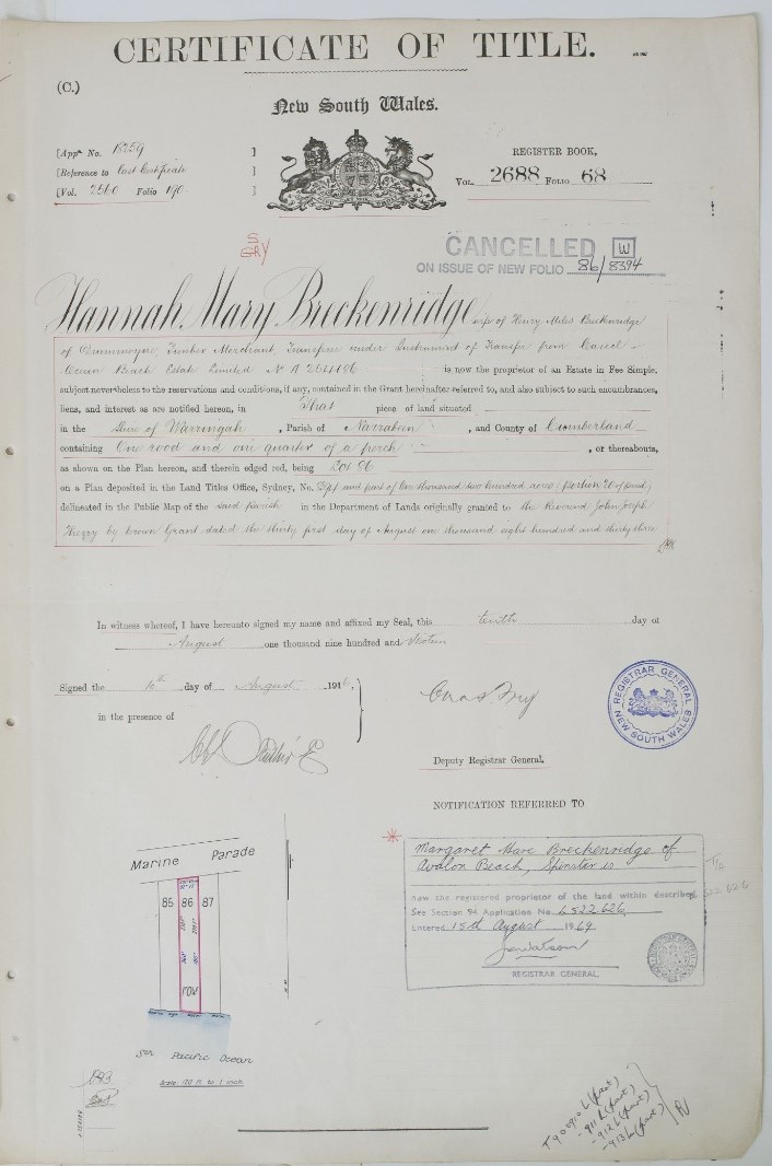
Careel Ocean Beach Estate lots - shaded ones already sold - shows placement of Lots 86-88:
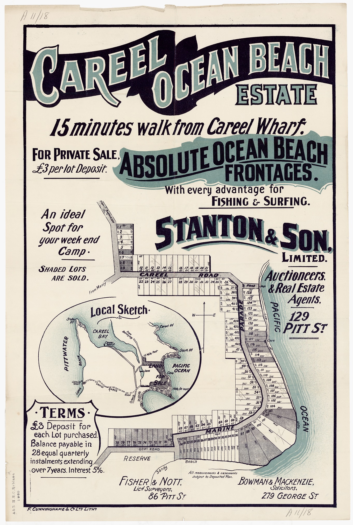
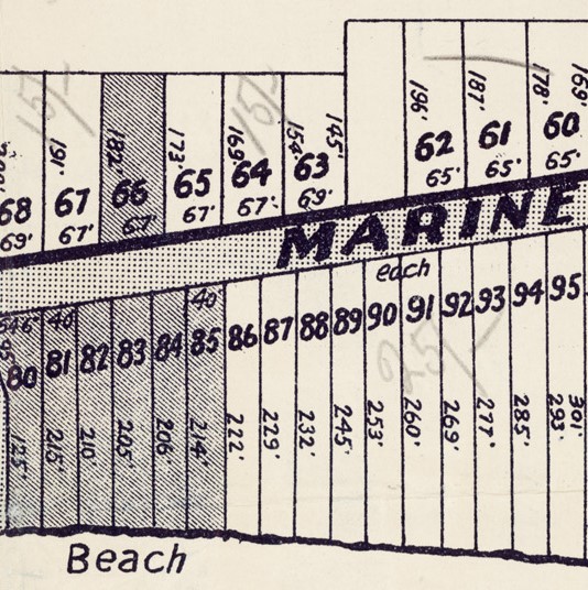
Tragically, their eldest son Thomas died by falling from North Avalon Headland while chasing a goat on December 3, 1921, aged just 10. The Coroner's Inquest found his fall was an accident.
MR. HENRY MILES BRECKENRIDGE.
In our last issue we referred briefly to the death of Mr. Henry Miles Breckenridge, which occurred at Drummoyne, on Monday, at the age of 66 years. The late Mr. Breckenridge, accompanied by his wife, son and daughter-in-law had been on a visit to Failford about a fortnight prior to becoming ill. He was taken ill with meningitis a week prior to his death. His brothers — Messrs. J. W. and T. M. Breckenridge (of Failford and Taree, respectively) and his sister (Miss Agnes Breckenridge, of Nabiac) went to Sydney to see their brother when he was seriously ill.
Mr. Henry Miles Breckenridge was the second son of the late Mr. and Mrs. John Breckenridge, and was born at Forster. In 1898 he went to New Zealand to learn the trade of shipbuilding and whilst there married Miss Lane. He returned to Failford in 1900 and resided there for six years, during which time he built the three-masted schooner Jap, which traded to New Zealand. Later the Jap was converted into a steamer and was subsequently lost off Cape Hawke. The late Mr. Breckenridge also constructed other craft whilst at Failford.
He went to Kendall in 1906 and built the sawmill there. After about five years there he removed to Drummoyne, Sydney, where he subsequently took over the hardwood timber business and mill of John Breckenridge and Sons, in which his principal interest was centred.
He was, however, also a director of several companies in Sydney. He was a member of the original Hawke football team of the early days, when the game was keenly played and some splendid teams were fielded.
Since residing in the city the late Mr. Breckenridge had been a keen and successful amateur, rock fisherman and a devotee of Avalon Beach, where he had a seaside cottage for the past 20 years. On one occasion, whilst fishing from the rocks, he and his son (then aged 3 years) were washed into the sea, but they fortunately escaped injury.
In addition to his widow, he is survived by a son (Ian) who resides in Sydney, and two daughters — Miss Margaret Breckenridge (at home) and Mrs. Basil Smith (Guyra). One son was accidentally killed at Avalon about 20 years ago.
The following brothers and sisters also survive their brother: Mr. J. W. Breckenridge (Failford), Mr. Robert Breckenridge (Eastwood), Mr. Forster Breckenridge (Dawson Valley, Queensland and formerly of Kendall), Mr. T. M. Breckenridge (Taree), Miss Agnes Breckenridge (Nabiac), Mrs. W. A. Cox (Drummoyne), Mrs. John Shiels (Charles town) and Mrs. O. J. Cross (Bellevue Hill, Sydney). a sister (Mrs. T. Lowrey, Nabiac) and a brother (Lieut. Hugh Breckenridge, killed at Bullecourt during the last war) predeceased their brother.
The funeral took place on Tuesday morning at the Field of Mars cemetery, being conducted by Rev. Greaves (Presbyterian). It was a coincidence that the funeral took place on the anniversary of the late Mr. Breckenridge's father's death. MR. HENRY MILES BRECKENRIDGE. (1941, July 15). The Wingham Chronicle and Manning River Observer (NSW : 1898 - 1954), p. 4. Retrieved from http://nla.gov.au/nla.news-article168512444
Hannah Mary Lane (circa 1876 - November 1 1968) born in New Zealand.
Thomas Major Lane Breckenridge (1911 - 1921), born August 25, 1911 at Drummoyne, New South Wales, died December 03, 1921 (aged 10) at Palm Beach, New South Wales, Australia (Accident).
A Boy's Terrible Fall.
100 FEET OVER CLIFF.
A shocking fatality ended a picnic party at Barranjoey on Saturday afternoon, when Thomas Major Lane Breckenridge, aged 10, who lived with his parents at Cary-street, Drummoyne, fell over 100ft. from the top of cliff to the beach, and was killed instantly. The boy was one of a party driven to Barranjoey by his uncle, Mr. Woodward. He was playing with another lad, James Grant Crockett, aged 10 years, who also lives in Drummoyne, near a spot called "Hole-in-the-Wall."
They were chasing young goats about the top of the cliff, when young Breckenridge got too close to the edge and slipped. His friend witnessed the occurrence and rushed back to Mr. Woodward, who had to go a considerable distance along the cliff before he could find a place to descend. When he reached the foot of the cliff he had nearly a mile to walk before he found the boy's broken body. He carried it back along the beach and up the cliff, and then returned in the car to Drummoyne, where Dr. Menzies pronounced life extinct. Deceased was the son of Mr. H. M. Breckenridge, of Drummoyne, and a nephew of Cr. J. W. Breckenridge of Failford. A Boy's Terrible Fall. (1921, December 7). The Manning River Times and Advocate for the Northern Coast Districts of New South Wales (Taree, NSW : 1898 - 1907; 1913; 1921; 1925 - 1930; 1932 - 1954), p. 2. Retrieved from http://nla.gov.au/nla.news-article174345858
BRECKENRIDGE. December 3, 1921, accidentally killed at Barrenjoey, Thomas (Lane), dearly loved son of Mr. and Mrs. H. M. Breckenridge, of 51 Carey-street, Drummoyne, aged 10 years.
BRECKENRIDGE.- The Funeral of the late THOMAS (LANE) BRECKENRIDGE will take place THIS (Monday) AFTERNOON, at Presbyterian Cemetery, Field of Mars, arriving at Cemetery gates at 3.30 o'clock. WOOD COFFILL LIMITED. Family Notices (1921, December 5). The Sydney Morning Herald (NSW : 1842 - 1954), p. 8. Retrieved from http://nla.gov.au/nla.news-article15990539
HOLIDAY FATALITY
Fell Over Cliffs DROP OF 250 FEET
The Coroner's Inquiry regarding the death of Thomas Major Lane Breckenridge, aged 10, who fell from the top of the cliff at Hole-ln-the-Wall, near Barrenjoey, on Saturday last, was held to -day.
James Grant Crockett, a schoolboy, who went with Mr. Breckenridge and his family to their week-end cottage at Hole-in-the-Wall, stated that at about 3 p.m., while they were playing together, it started to rain, and they went a little distance down the cliff. Seeing a goat they chased it, and after a short run he heard the deceased say, "Woofs!" They were then on a ledge three or four feet wide. On looking back he saw his friend fall over the edge. He hurried back to tell the others what had happened.
Charles Edward Woodward, an oyster merchant, who was fishing nearby, stated that he found the boy's body after a walk of a mile along the beach. He had fallen about 250 feet. The body was carried to the top.
Henry Miles Breckenridge said that he drove back to Drummoyne with his son's body, and Dr. Menzies pronounced life, extinct. Dr. Guy Dixon Menzies said that in his examination of the body he found a fracture of the leg and severe injuries to the body, back and head. Death was instantaneous. A verdict of accidental death was recorded. HOLIDAY FATALITY (1921, December 9). The Sun (Sydney, NSW : 1910 - 1954), p. 9 (FINAL EXTRA). Retrieved from http://nla.gov.au/nla.news-article223484755
BRECKENRIDGE.— At a private hospital, July 8, 1917, John Breckenridge, of "Kulcaway," St. George's Crescent, Drummoyne, and late of Failford, North Coast, in his 71st year. Family Notices (1917, July 9). The Daily Telegraph (Sydney, NSW : 1883 - 1930), p. 4. Retrieved from http://nla.gov.au/nla.news-article239373932Death.
BRECKENRIDGE.— At his residence, on July 8th, 1917, "Kulcaway," Drummoyne (and late of Failford), JOHN BRECKENRIDGE, aged 71 years. The funeral takes place at Failford Cemetery at 2 p.m. on Wednesday, 11th July. Family Notices (1917, July 11). The Northern Champion (Taree, NSW : 1913 - 1954), p. 5. Retrieved from http://nla.gov.au/nla.news-article157184015
Obituary.
MR. JOHN BRECKENRIDGE.
News was received in Taree on Monday that Mr. John Breckenridge had died at his residence, Drummoyne, on Sunday, the cause of the death being pneumonia and complications. He was about 70 years of age. The deceased gentleman was widely known in shipping and timber circles, and was head of the firm of Breckenridge and Sons, Ltd., of Drummoyne, with branches at Failford and Kendall. The late Mr. Breckenridge took up residence in the Wallamba district at about the same time as the late Mr. John Wright, and both were engaged in the timber industry. Mr. Breckenridge's mill was at Failford. He was a decidedly progressive citizen, and by his enterprise did much to develop the timber industry out Wallamba way. He was a good living man, and one of high business integrity. One of his sons. Mr. Wyllie Breckenridge, manages the Failford mill; and Messrs. Forster and Thomas the one at Kendall. Another son, Hugh, enlisted, and has been posted as missing for a long time. A daughter, Mrs. T. Lowrey, of Nabiac, predeceased her father by some years. His widow survives him. The body was brought up by train on Tuesday, and will be interred in the Failford Cemetery to day (Wednesday) at 2 p.m. Obituary. (1917, July 11). The Northern Champion (Taree, NSW : 1913 - 1954), p. 2. Retrieved from http://nla.gov.au/nla.news-article157183988
Late Mr. Breckenridge.
At the meeting of the shire council on Tuesday sympathetic reference was made to the death of Mr. John Breckenridge. Cr. Irvine, who was presiding in the afternoon during the temporary absence of the president, moved that the clerk forward a letter of sympathy to Mrs. Breckenridge and the family.
He said that the late gentleman had been first president of the council at its formation, and had given valuable services. He had rendered great services to not only the shire council and the district, but to the State generally. Cr. Parker seconded, and said that in addition to the loss of her husband; Mrs. Breckenridge had been bereaved of one of her sons, who had long been missing from the front. Cr. Newton supported the motion, and said that he had known the deceased gentleman from the time that he (the speaker) was in knickerbockers. He was one of the pioneers of the Wallamba, and also of Camden Haven, and was one of the whitest men who ever lived in the Manning Shire. There was nothing In which he did not take a leading part, and his sons were following In his footsteps. The motion was agreed to. Late Mr. Breckenridge. (1917, July 14). The Northern Champion (Taree, NSW : 1913 - 1954), p. 4. Retrieved from http://nla.gov.au/nla.news-article157176194
LATE MR. J. BRECKENRIDGE.
Probate has been granted of the will of the late Mr. John Breckenridge, of Drummoyne, timber merchant, who died on July 8 last. Testator desired that his funeral expenses should not exceed £10, and that his body should be cremated if there were facilities therefor at the time of his death. To his son, John Wyllie Breckenridge, testator bequeathed two lots of 145 acres and 40 acres, in the parish of Tuncurry, county of Gloucester. The residue of testator's property, including shares, was devised to his widow. The net value of the estate is £25,753, of which £20,010 consists of shares in public companies. - The Sydney Morning Herald (NSW : 1842 - 1954) Wednesday 7 November 1917
OBITUARY
MRS. MARY BRECKENRIDGE.
Mrs. Mary Breckenridge; relict of the late John Breckenridge, of Fail-ford, passed away at her late residence, 65 Lamrock Avenue; Bondi, Sydney, on Saturday. The late Mrs. Breckenridge, was one of the best known residents of the Wallamba River, being a member of the well-known Miles family. Mr. Breckenridge died some years ago, but the widow continued to reside in Sydney.
The sons include Cr. J. W. Breckenridge (Failford), Cr.. T. M. Breckenridge (president of Hastings Shire), and, Mr. Harry Breckenridge (Sydney). Brothers of deceased were Messrs. Harry, Thomas, Josiah and James Miles, of Forster. The funeral took place on Tuesday afternoon at 2 p.m., leaving the residence of Mr. J. W. Breckenridge for the Failford Cemetery. There the Rev. J. W. McCredie of-ficlated at the graveside, and paid a fitting tribute to the memory of the deceased lady. The funeral was a most representative one, and gave proof of the fact that deceased was held in the very highest esteem by all sections of the community. It might be mentioned this is the first break in the Miles family chain, and it is also worthy of note that the late Mrs. Breckenridge had attained the good round age of 77 years. The whole of deceased's brothers were present at the funeral and were as follows: Messrs. Thomas, Jossiah, Henry, and James Miles. Mrs. Dun, of Glenreah, is deceased's only sister. Deceased leaves the following family: Messrs.- J. W. Breckenridge (Failford), Harry, Robert, and Forster (Drummoyne), Mr. Thos. Brecken-ridge (Taree). The daughters living are: Miss Agnes (Bondi), Mrs. O. Cross (Mos-man), Mrs. W. A. Cox (Belmore), Mrs. John Shields (Comboyne). One son—Lieut Hugh Breckenridge — was killed in France during the Big War. Two daughters also predeceased their mother. They were: Mrs. Tom Lowry, and Miss Lily Breckenridge. OBITUARY (1928, March 23). The Wingham Chronicle and Manning River Observer (NSW : 1898 - 1954), p. 4. Retrieved from http://nla.gov.au/nla.news-article166274653
BRECKENRIDGE FAMILY AND SHIPPING
The involvement of the Breckenridge family in shipping is closely linked with the family’s interests in sawmilling and timber. John Wylie Breckenridge (1818 – 1899) was born in Scotland and emigrated to Australia in 1859, settling in the Port Stephens District where other members of his family were involved in sawmilling. Accompanying him from Scotland was his wife, Lillias Reid (1826 - 1870) and their two children, John (born 1846) and Agnes Keyes (born 1849). They had six more children between 1850 and 1870. His first wife Lillias died in 1870; he then married Maria Croker in 1872 and they had seven children; in total John Wylie Breckenridge had 15 children.
In February 1868, John Wylie Breckenridge, in partnership with a Mr. Joseph Barling of Stroud, established a saw mill on a 5-year crown lease at Cape Hawke in the area now known as Forster. John's wife Lillias died in April 1870, not long after the birth of their eighth child. After operating the mill for over three years, the partnership of Barling and Breckenridge was terminated; the saw mill and lease were sold in November 1871 but the business was continued as J. W. Breckenridge and Son. The mill and the lease of the land was purchased by John Booth - John Booth’s financial involvement in the mill is not known but John Breckenridge snr and his son continued to manage the mill and appear to have purchased it around 1873.
After purchase by John Booth, the mill was then operated by John Wylie Breckenridge (1818 - 1899) and his son John Wylie Breckenridge jnr. (1846 – 1917) and by 1874 the business was known as John Breckenridge and Sons.
Around this time the firm started building up a fleet of ships to provide direct access to markets for the sawmill at Forster. The first vessel ("Hoolet" of 30 tons) was built at Forster by Richard Phegan in 1875; she was unfortunately wrecked in 1876. A second vessel was commissioned from Leonard Steinmetz but details are unavailable. By late 1876 another vessel (also known as "Hoolet") was completed by William Piper (also of Forster) for Breckenridge and Sons. The new "Hoolet" was a 30 ton vessel and it is plausible to think that materials salvaged from the wreck earlier in the year were used to construct the new "Hoolet". Boatbuilding was commenced with the large punt "Forster" being constructed by William Breckenridge (John Breckenridge’s uncle) in 1874.
The Forster sawmill was sold to Messrs. Josiah and Thomas Miles in 1884.
After the sale of the sawmill, John Breckenridge (then aged 28) set up a larger sawmill at Failford on the Wallamba River and became a key player in both the sawmilling and boatbuilding industries of the Great Lakes. John’s father, John Wylie Breckenridge, who has been referred to as the “Founder of “Forster”, lived in Forster until his death in 1899. He is buried in Forster cemetery.
John Breckenridge married Mary Miles in 1872 and had twelve children: John Wylie (1873), Henry Miles (1875), Robert (1876), Elizabeth (1878), Lily (1880), Forster (1882), Agnes (1883), Tom (1885), Mary (1886), Hugh (1888), Emily (1890) and Minnie (1893).
While John Breckenridge owned the sawmill at Failford he employed two of his sons – John Wylie (J.W.) Breckenridge and later Henry Miles (H. M.) Breckenridge – as managers and all three were involved in shipbuilding activities; It seems most likely that John Breckenridge and his son, John Wylie Breckenridge (then aged 18), were involved in some way in the construction of the “Commonwealth” in 1901.
Other members of the Breckenridge family were also involved in shipbuilding including John’s uncle (William Breckenridge) and John’s brother Hugh Breckenridge (1867 – 1950).
John Breckenridge moved to Drummoyne in 1909 and set up John Breckenridge and Sons, Ltd. in 1911; John and his two sons, J.W. and H.M., were directors. John died on 8th July 1917 and is buried in Failford cemetery. In front of his headstone is a memorial to his son, Hugh (1888 – 1917); Hugh died on 3rd May 1917 at Bullecort in France.
References:
Purchase of sawmill at Cape Hawke by John Booth - Illustrated Sydney News Saturday 23 November 1872.
Launch of the “Commonwealth”. The Sydney Morning Herald. Tuesday 11 June 1901
False alarm. The Register (Adelaide, SA : 1901 - 1929) Monday 16 September 1901
Coastal Steamer Founders. Northern Star (Lismore, NSW) Monday 28 August 1916
The "S.S. Commonwealth" in the Gale. Excerpts from the Manning River Times - published by Bob Mann, February 1971.
Harley Usill Mackenzie was the eldest of five sons of Walter and Frances Mackenzie (nee Usill).
MARRIAGE.
MACKENZIE —USILL. —On the 24th instant, at St. Michael's Church, Wollongong, by the Rev. T. C. Ewing, Walter Fawkes Mackenzie, Esq., M.R.C.S. and L.S.A., England, and Licentiate of the Royal College of Physicians, Edinburgh, of West Maitland, to Frances, second daughter of the late Harley Matthew Usill, Esq., of Wisbeach, Cambridgeshire, England. No cards. 720 Family Notices (1865, January 31). The Maitland Mercury and Hunter River General Advertiser (NSW : 1843 - 1893), p. 1. Retrieved from http://nla.gov.au/nla.news-article18706709
Children - from NSW BDM's Records:
MACKENZIE HARLEY U 10182/1867 WALTER F FRANCES HARTLEY
MACKENZIE WALTER F E 11703/1869 WALTER F FRANCES HARTLEY
MACKENZIE EDITH USILL 10863/1870 WALTER FARRKES FRANCIS HARTLEY
MACKENZIE ARTHUR C 2805/1873 WALTER F FRANCES SYDNEY
MACKENZIE WILLIAM K S 386/1872 WALTER FAWKES FRANCES SYDNEY
MACKENZIE ERIC BLUNDELL 2141/1875 WALTER FAWKES FRANCES SYDNEY
The Mackenzies lost one son while quite young and Dr. Mackenzie passed away before the boys were grown too. Fortunately he had established a form of income for his family in mining interests prior to passing away - a few news items tell the story:
MACKENZIE—Dec. 10, Sydney, Walter Fawkes Edwards, second son of Dr. W. F. Mackenzie, aged 7 years. Family Notices (1875, December 25). The Sydney Mail and New South Wales Advertiser (NSW : 1871 - 1912), p. 813. Retrieved from http://nla.gov.au/nla.news-article162489288
MACKENZIE.-October 14, 1886, at Lyons-terrace, Sydney, Dr. Walter Fawker Mackenzie, aged 51. Family Notices (1886, October 23). The Sydney Mail and New South Wales Advertiser (NSW : 1871 - 1912), p. 879. Retrieved from http://nla.gov.au/nla.news-article164381257
DOCTOR MACKENZIE, — Doctor Walter Fawkes Mackenzie, chief medical officer of the Australian Mutual Provident Society and medical examiner to the Board of Education, died in his residence on Thursday after a short illness. He was a member of the Royal College of Physicians of Edinburgh, and of London. The deceased gentleman commenced his career early in the decade '60 to '70 in West Maitland, and afterward removed to Wallerawang, which place he left for Sydney. Dr. Mackenzie was one of our best known metropolitan practitioners, and was highly respected. His practice was chiefly with families, and his handsomely appointed brougham was a familiar, object in the fashionable thoroughfares in and about Sydney. He was brother to the examiner of coal fields. He leaves a widow and five children. General News. (1886, October 16). Evening News (Sydney, NSW : 1869 - 1931), p. 9. Retrieved from http://nla.gov.au/nla.news-article107317674
"Amicus" writes: — "The late Dr. Walter Fawkes Mackenzie was a man whom it was impossible to know without eutertaining a sincere appreciation for his sterling worth. Always cheerful, never at any time mentally depressed, and full of energy, he possessed a gaiety of heart that lent itself in an 'infective' manner to those in his company. Possessing wondrous tact and xavoir J aire he took infinite pains to use these special gifts to the best interests of those enjoying his friendship. Ho was devoted to his profession and enjoyed the benefits of a largo and lucrative practice, but such were his systematic arrangements and habits .of routine that he seemed fairly to revel in his active duties. Full of consideration to all, aud especially to those in his service he, to whom time was more vnlunblo than to most men, would go out of his way to do a friend a good turn, with a charming air of bouhomie that would leave the recipient for ever grateful. His nature was singularly free from any jealous feelings, and to his profession and the members thereof be was loyal to the core, many of whom are much indebted to his kindly interest on their behalf." GENERAL NEWS. (1886, October 19). The Daily Telegraph (Sydney, NSW : 1883 - 1930), p. 5. Retrieved from http://nla.gov.au/nla.news-article239322572
LOCAL NEWS.
The Late Dr. W. F. Mackenzie.-This gentleman, who was one of the leading members of the medical profession in Sydney, died at his residence on Thursday, after a short illness. Dr. Mackenzie was born in Lancashire and took his diplomas in Edinburgh and London. He arrived in the colony in 1862, and settled in the first instance at West Maitland, where he soon obtained a very large practice, under the pressure of which his health gave way. He retired for a time to Wallerawang, in the Blue Mountains, where he had a property, and on regaining his strength resumed his profession in Sydney, where he enjoyed a large practice up to the time of his death. In 1876 he was appointed medical officer, to the Australian Mutual Provident Society, the duties attached to which position he discharged to the entire satisfaction of the board. The work was onerous, involving the personal examination of from 400 cases annually, and the revision of all the medical reports from the country. His loss will be severely felt, not only in his own immediate family circle, but also by a large number of friends by whom he was much esteemed for his genial disposition, his generosity, and up-rightness. He leaves a widow, and five children, of whom the eldest is not yet of age. At the meeting of the medical section of the Royal Society which was hold last night, the following resolution was proposed and unanimously carried-"That the section has heard with deep regret of the death of Dr. Walter Fawkes Mackenzie ; and that the section do now adjourn as a mark of the respect and esteem with which he was regarded."-Herald. LOCAL NEWS. (1886, October 19). The Maitland Mercury and Hunter River General Advertiser (NSW : 1843 - 1893), p. 5. Retrieved from http://nla.gov.au/nla.news-article18891044
SUPREME COURT.-THURSDAY, MAY 21.
BEFORE, Mr. Justin FAUCETT, and Mr. Justice INNES )
MACKENZIE VS. MACKENZIE
... was the appeal of the defendant, Dr. Walter Fawkes Mackenzie, against the decree of his Honor the Primary Judge declaring his brother, the plaintiff, John Mackenzie, examiner of coaIfields, to be a partner with him in certain valuable coal and shale lands near Wallerawang....
The CHIEF JUSTICE, in delivering judgment, said that if there were nothing else to be considercd but the deed poll, there would be no question that it gave the defendant a rompíalo right to the property. However, the relation of the parties in respect to the property from the execution of the deed in 1870 down to 1883 showed that no change had taken place in the ownership. Although no works were carried out, and no coal extracted, efforts were made in various quarters to make aouie portion of the land available by selling It, and during all these transactions the plaintiff and defendant had corresponded and talked together when it became necessary, until at some time in July, when the plaintiff wrote for copies of deeds, in order to have his position put on some satisfactory bans. Apart from the authorities which had been stated it was quite evident that when two persons entered into partnership to work ... properties they being the a> le matter of the partnership, when one conveyed his interest to the other the partnership could not be ...must be a dissolution. If the plaintiff came to that Court with such a OKI» as that he would have no ground for asking ... appeal was therefore dismissed with costs, the Court Joining in a recommendation to the parties to ..come to some arrangement. LAW REPORT. SUPREME COURT.—THURSDAY, MAY 21. (1885, May 22). The Sydney Morning Herald (NSW : 1842 - 1954), p. 5. Retrieved from http://nla.gov.au/nla.news-article13589044
Kerosene Vale
Description:
Is a rural place and a valley located 2km east of Lidsdale. It has the creek system, Sawyers Swamp, flowing through it. Dr Walter Fawkes Mackenzie (1835-1886) applied for a Mineral Lease of 240ac at Sawyers Swamp in 1866. Ref: Survey Plan C290.1507. In a few short years, his holdings in this area had increased to 691ac (279ha). It was due to the shale, also referred to as Torbanite, mined in this locality for its oil content, which produced, when processed, kerosene. The mining in this area resulted in the locality being called Kerosene Vale. At present, this area is used as a repository for the dry ash generated by the Wallerawang Power Station. Constructed in 1960, it was filled with a combination of by product ash from the Wallerawang Power Station and mining spoil.
Harley's brother William Kenneth Seaforth Mackenzie was a gentleman known for his Military Service and for his care of the men under his command during WWI, although this item, in noting his death, refers back to the industry started by his father and his father's brother:
SEVERANCE OF LINK WITH EARLY MINING HISTORY
In last Saturday's Herald was a notice stating that Lieut. Colonel William K. S. Mackenzie, D.S.O., who was admitted to the New South Wales Bar in 1895, died last Tuesday.
This is of more than passing interest to people, interested in mining in this district and possibly others, reports Mr. E. J. McKenzie, research secretary of the Lithgow Historical Society. It was Colonel Mackenzie's father (Dr. Walter Fawkes Mackenzie) and his uncle (John Mackenzie) examiner of coal mines in the early days of the Mines Department, who established the kerosene oil industry at Kerosene Vale, Lidsdale, in the 1860's. In the Bathurst Times of November 20, 1867, it was reported that a consignment of 200 gallons of "Cannelite oil from Mackenzie Bros' oil works near Bowenfels had reached Bathurst. It appears that be cause of the pale amber color of the oil the public were prejudiced against is in favor or the American oil which was clear in color. Up till about 10 years ago Kerosene Vale was one of the beauty spots of the district. The Mackenzies, who by the way came from Wiggan, England, planted the place with ornamental trees and shrubs. During the last war the poplars' and redwoods were sold and taken to mills , in Sydney for manufacture into better class furniture, etc., but with the remaining shrubs, along with the unusual natural formation of the place, it still retained much of its charm as a picnic ground. SEVERANCE OF LINK WITH EARLY MINING HISTORY (1952, June 12). Lithgow Mercury (NSW : 1898 - 1954), p. 4. Retrieved from http://nla.gov.au/nla.news-article219826938
Harley died quite young:
MACKENZIE - March 3 1916, at St Vincent's. Private Hospital Darlinghurst, Harley Usill Mackenzie aged 49 years. Family Notices (1916, March 4). The Sydney Morning Herald (NSW : 1842 - 1954), p. 16. Retrieved from http://nla.gov.au/nla.news-article15641578
MR. HARLEY MACKENZIE DEAD
The death of Mr. Harley Ursill Mackenzie, one of Sydney's best-known solicitors, and a member of the legal firm of Messrs. Bowman and Mackenzie, of this city, In St. Vincent's Private Hospital on Friday, was consequent upon an operation for appendicitis. Deceased who was in his 49th year, was a son of Dr. Mackenzie, of Sydney, and a brother of Lieutenant-Colonel Mackenzie, now at the front, and formerly Associate to Mr. Justice Gordon, Judge in Divorce. Mr. Mackenzie was well known in social and sporting circles in this State. The interment took place yesterday afternoon at Burwood, in the Church of England portion of the cemetery. The funeral was, large and representative, and Included many legal men. Amongst those who forwarded wreaths were the directors of the Hotel Pacific, Mr. and Mrs. Septimus Levy, Mr. and Mrs. Harry Levy, the management and staff of the Hotel Pacific, Dr. and Mrs. Herbert- Marks, Mr. and Mrs. Frank Macdonald, Mrs. and Miss Lewis, Mr. John Mackenzie. Misses Hay, Mr. and Mrs. J. B. Osborne, Mr. and Mrs. Phillip Morton, the guests of the Hotel Pacific, Rachael Joy Martin, Mr. and Mrs. Reginald Allen, the board of directors of the Royal Prince Alfred Hospital; Mr. Harry Chisholm, Mr. Venour Nathan, Mr. A. G. Andrews, Mr. Edwin Geach, Mr. and Mrs. Owen Prosser, and Misses Morton. MR. HARLEY MACKENZIE DEAD (1916, March 5). The Sun (Sydney, NSW : 1910 - 1954), p. 5 (SUNDAY EDITION). Retrieved from http://nla.gov.au/nla.news-article221360635
In the Supreme Court of New South Wales.
PROBATE JURISDICTION.
In the will of Harley Usill Mackenzie, late of Sydney, in the State of New South Wales, solicitor, deceased.
PURSUANT to the Wills, Probate and Administration Act, 1898: Notice is hereby given that all creditors and other persons having any claims upon or being otherwise interested in the estate of the abovenamed deceased, who died at Sydney aforesaid on the 3rd day of March, 1916, are hereby required to send in full particulars of their claims to the undersigned, the proctors for the executors of the will of the said deceased, before the 25th day of October next, after which date the said executors will proceed to distribute the assets of the said deceased amongst the parties entitled thereto, having regard to the claims of which they shall then have notice ; and the said executors shall not be liable, for the assets or any part thereof so distributed, to any person of whose claim they shall uot have had notice at the time of such distribution.—Dated this 8th day of September, 1916.
BOWMAN AND MACKENZIE,
Proctors for the Executors,
279 George-street, Sydney. PROBATE JURISDICTION. (1916, September 15). Government Gazette of the State of New South Wales(Sydney, NSW : 1901 - 2001), p. 5610. Retrieved from http://nla.gov.au/nla.news-article225845310
His brother W K Mackenzie was in charge of his estate, and that of his brothers
William Kenneth Seaforth Mackenzie war service:
Colonel Mackenzie, who completed his first year of active service at the front to-day, is in good health and spirits, according to a letter received from him by Mr. Justice Gordon yesterday. Prior to going to the war Colonel Mackenzie, who Is a member of the New South Wales Bar, was Associate to his Honor. MEN AND WOMEN (1916, June 14). The Sun (Sydney, NSW : 1910 - 1954), p. 6 (FINAL RACING). Retrieved from http://nla.gov.au/nla.news-article221351053
Informal portrait of two 61st Battalion officers at a camp in southern England. Identified left to right: Captain Arthur Havelock Hirst; Lieutenant Colonel William Kenneth Seaforth Mackenzie, DSO, Officer Commanding. Place made: United Kingdom: England, Dorset, Wareham, Date made: May 1917, Conflict First World War, 1914-1918 - courtesy Australian War Museum
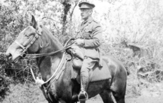
Colonel William Kenneth Seaforth Mackenzie, DSO, Officer Commanding Place made: United Kingdom: England, Dorset, Wareham, Date made: May 1917, Conflict First World War, 1914-1918 - courtesy Australian War Museum
THE 19th BATTALION.
The following is an extract from a letter from Colonel Mackenzie of the 19th batt., dated August 14-
__"At times we have had an issue of fresh clothing, and have been able to purchase extra food from canteens or village shops, but this is not invariably the case. There are times when men greatly need a clean change and frequently we are unable to purchase extra., at least, to the extent desired. Only a week or so ago, a consignment of shirts, socks, etc, came to hand. The time was most opportune, and the clean shirts and socks were eagerly taken up and soiled ones discarded. Shirts and socks are the two items most required. Those sent are entirely satisfactory and I hope our committee and continue to send them. The short khaki pants are also much appreciated. There is a distinct craving for sweet things. Men who, in ordinary life, would scarcely dream of buying chocolate and sweets, seem to acquire a taste for them here. Cigarettes are always acceptable, and at times the men sadly need them. We get an issue of two packets (20 cigarettes) a man per week, but as a man will smoke at least a packet a day there are times when men (if not near a canteen) run out of cigarettes.”
Gifts of books and fiction magazines are earnestly requested by the 19th Battalion Comforts Fund, 11 Bent- street, for the use of the reinforcements leaving on the transports.
'The Sevres porcelain factory has been transformed since the outbreak of war Into a great munition factory producing materials for manufacturing explosives. THE 19TH BATTALION. (1916, October 20). The Sydney Morning Herald (NSW : 1842 - 1954), p. 8. Retrieved from http://nla.gov.au/nla.news-article15676773
William passed away in 1952, preceded by his mother, who was living in Victoria - probably with youngest son Cecil who was an Engineer and employed by the Melbourne Harbor Trust - and brother Eric and sister Edith, who died within months of each other:
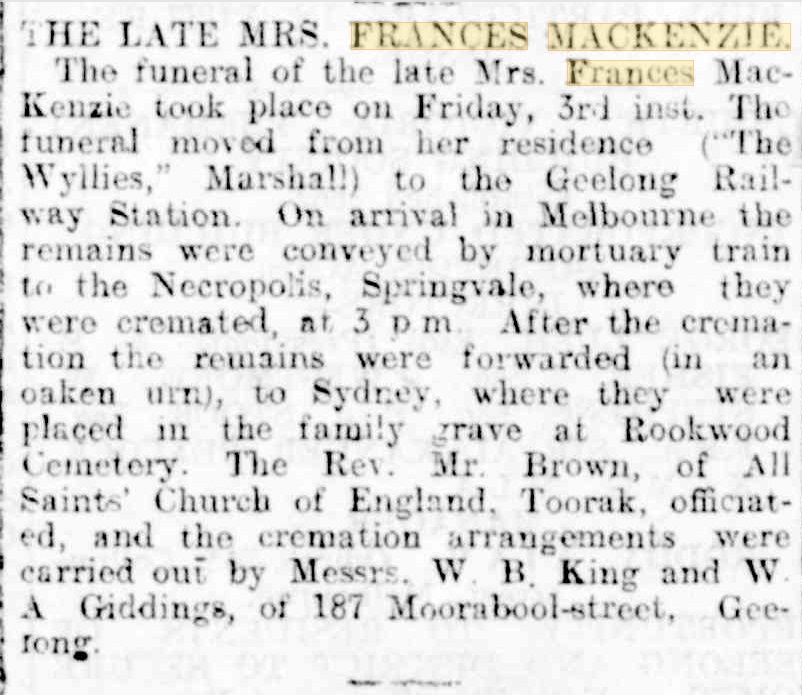
THE LATE MRS. FRANCES MACKENZIE. (1918, May 11). Geelong Advertiser (Vic. : 1859 - 1929), p. 7. Retrieved from http://nla.gov.au/nla.news-article119695933
MACKENZIE.—At The Wyllies, Marshall, Victoria, Frances, widow of the late Dr. Walter Fawkes Mackenzie, of Sydney, N.S.W. Family Notices (1918, May 3). Geelong Advertiser (Vic. : 1859 - 1929), p. 1. Retrieved from http://nla.gov.au/nla.news-article119695022
AFTER fourteen clear days application will be made to the Supreme Court of the State of Victoria, in its Probate Jurisdiction, by William Kenneth Seaforth Mackenzie, of Sydney, in the State of New South Wales, barrister-at-law, the surviving executor to whom probate of the will and one codicil of EDITH USILL MACKENZIE, late of Number 24 Darlinghurst road, Sydney, in the State of New South Wales, spinster, deceased, was granted by the Supreme Court of New South Wales, in its Probate Jurisdiction, on the eighth day of February, one thousand nine hundred and forty-four, Eric Blundell Mackenzie, of Bayswater road, Sydney, In the State of New South Wales, Gentleman, the other executor named In the said will, having died on the third day of September, one thousand nine hundred and forty-five, that the said probate be RESEALED with the seal of the said Supreme Court of Victoria. Dated the fifth day of October, one thousand nine hundred and forty-five. KROROUSE. OLDHAM, & DARVALL, of 352 Collins street, Melbourne, solicitors for the applicant. Advertising (1945, October 5). The Argus (Melbourne, Vic. : 1848 - 1957), p. 18. Retrieved from http://nla.gov.au/nla.news-article12145380
LEGAL NOTICES IN THE SUPREME COURT OF NEW SOUTH WALES.— PROBATE JURISDICTION.— No. 319829.— Hi the Will of ROBERT LE GAY BRERETON formerly of The Rock in the State of New South Wales late of Royal Australian Air Force deceased. NOTICE is hereby given that the First Accounts in the above Estate have been filed this day in my office Sydney and all persons having any interest in the said Estate may come in before me at my said office on or before the twenty-third day of October 1947 at 10.30 o'clock in the forenoon and inspect the same and if they shall think fit object thereto otherwise if the said accounts be not objected to the same will be examined by me and passed according to law. Dated this 23rd day of September 1947. CHAS. E. BUTCHART (L.S) Registrar.
IN THE SUPREME COURT OF NEW SOUTH WALES.— PROBATE JURISDICTION.— In the Will and Two Codicils of Eric Blundell Mackenzie late of Darlinghurst in the State of New South Wales Retired Grazier deceased. APPLICATION will be made after 14 days from the publication hereof that Probate of the last Will and Testament of the abovenamed deceased dated the 23rd day of January 1941 and two Codicils thereto dated respectively the 18th day of April 1941 and the 24th day of June 1943 may be granted to William Kenneth Seaforth Mackenzie and Hilton Raymond Gordon two of the Executors named therein, Edith Usill Mackenzie and Wilfrid Mount Batten the other Executors named therein having predeceased the Testator and all Notices may be served at the undermentioned address. All creditors in the Estate of the deceased are required to send in particulars of their claims to the undersigned. Bowman & Mackenzie Proctors for the Executors 133 Pitt Street Sydney. Advertising (1947, September 25). The Daily Telegraph (Sydney, NSW : 1931 - 1954), p. 32. Retrieved from http://nla.gov.au/nla.news-article248104558
MACKENZIE, William Kenneth Seaforth.-June 3, at Sydney, late Lieut.-Colonel 19th Batt., First A I.F., beloved brother of Arthur Cecil. By request, no flowers. Family Notices (1952, June 4). The Sydney Morning Herald (NSW : 1842 - 1954), p. 26. Retrieved from http://nla.gov.au/nla.news-article18267546
A snippet about Arthur Cecil:
Harbor Engineer Resigns Position
Mr, Mackenzie Desires to Enter Private Practice
A BRILLIANT PUBLIC CAREER
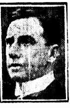 Surprise no doubt will be expressed In engineering circles at the announcement of the resignation of Mr. Arthur Cecil Mackenzie, M. Inst. C.E.. chief engineer of the Melbourne Harbor Trust, In order to enter private practice. "
Mr G. F. Holden stated today that the resignation of Mr Mackenzie had been accepted by the Harbor Trust Commissioners. His term of office expires at the end of the year. In accept-Ing the resignation, the Chairman of the Harbor Trust and the Commissioners referred to the excellent services performed by Mr Mackenzie during his period of office as engineer to the Trust. A successor has not yet been appointed, but the matter is now under the consideration of the Commissioners. In the engineering world Mr Mackenzie occupies a front rank position,
Mr A. MACKENZIE
and his career has been characterised by brilliancy, industry, and , originality. It Is doubtful whether there Is another man In the Commonwealth rivalling the high qualifications he holds in his particular department of activity. The commissioners will find it difficult to replace mm.
Son of the late Mr Walter Fawkes Mackenzie, of Sydney, the retiring engineer was educated at the Sydney Grammar School,- where he distinguished himself In mathematics. In his early youth Mr Mackenzie nurtured a penchant for engineering. Leaving school, Mr Mackenzie went to London for experience, serving his articles with the London and Great Northern Railway Company. Five years later he went to China on railway construction Work"
Fighting the Boxers
During the Boxer rebellion In 1900. when the members of the Chinese Secret Society made a fierce attack upon foreigners and Christians, Mr Mackenzie was one of those who enlisted for active service in Northern China. After experiencing what he describes as "an uncanny time in that bloodthirsty country, Mr. Mackenzie returned to Sydney, taking up a responsible position on the staff of the Sydney Harbor Trust. There he remained ' for another five years, then migrating to Geelong to fill the post of Engineer-in-Chief of the Geelong Harbor Trust during the presidency of the late Mr E. 1-L Liiscelles. Only those aware of the great enter-urlso shown by the throe Geolong Commissioners during the next seven years can obtain any idea of the magnitude of the work undertaken by Mr Mackenzie and the' highly efficient manner in which It was executed. Mr G. F. Holdon succeeded Mr Lascelles as chairman"
His Ability Recognised
The Government was not slow to recognise the progressive policy and sound administrative ability shown by tbo /former' who, when offered the more lucrative position of chairman of the Melbourne Harbor Trust, accepted. Neither did they overlook the engineering capacity of Mr Mackenzie, -whom they - appointed chief engineer. Mr Mackenzie is a. member of -the Council of the Victorian Institute of Engineers, and is also a member of the Advisory Council of the London Institute of Engineers. He has decided to enter into partnership with Messrs. Charles D'Ebro and Meldrum.
A Gigantic Task.'
The gigantic, task of remodelling the whole inner port, devolved upon Mr Holdon and Mr Mackenzie who drew up all the plans in connection therewith. It Is. 'to be a long and- costly contract, but Its completion will give Melbourne one of the most wonderful harbors In the world. The estimated cost is over £6,000,000. In planning works for 30 years ahead the Harbor Trust Commissioners have given evidence of an Inspiring enterprise. Among other things, the Harbor Trust scheme drawn up by Mr Mackenzie (which is being adopted in its entirety) provides for many miles of double-sided wharves, served by railroads and tramways converging into the base of the State railway system in Spencer street, and branching into factories, stores ' and workshops of Port. South, and North Melbourne. Victoria Dock, at the' head of Coodo Canal, is to be supported by a service of four other and greater parallel works, cut to a depth' of 32ft. into the silt, and divided by spacious wharves and piers.
Improvements Planned
A new road will be driven from Queen's Bridge along the base, line of the harbor works to the river mouth, and along the! road will run on electric tramway, reducing the Journey between Williamstown and the city from miles to four 'miles. A tunnel or- a transport bridge, will carry the trams and other traffic across the river into the old seaside suburb. The trams will serve not only the wharfside business, but the coming residential settlement on the undeveloped part of Port Melbourne, west of the railway. A huge swamp area, that for half a century has been an eyesore — a seemingly rotten, core in the heart of the Port ' Phillip settlement — is being redeemed. The Harbor Trust Commissioners are cutting out the dross as one would excise the bruised portion from ah apple.
Nature left the biggest part of the task to human hands. A fleet of bucket dredges, barges, and rock drills, and an arsenal of blasting apparatus will be required to shape the inner port but of the silt beds. It Is the contention of Mr Mackenzie that as the development of a harbor is work of national importance, it cannot be left to private enterprise, which caters only for berth-ago accommodation for its own personal requirements, without thought of the general trade for which provision is required, and without giving due consideration to future expansion. Extensive powers are required, 'he maintains, which can only be obtained by Act of Parliament, and the reservation of large areas of suitable land and water frontages is indispensable.
Sydney's Bad Example
As an instance of the lack of the realisation at an early date of the requirements for future port development, Mr Mackenzie cites Sydney as a typical example, where practically the whole of the harbor foreshore has been alienated by titles for land being granted to high water mark. Fortunately for Melbourne, the Crown reserved some 3824 acres of land adjoining the River Yarra and Hobson’s Bay, which Is the most Sukarno for port development. This action was taken 75 years ago at the instigation of citizens, who were responsible for the formation of the Harbor Trust In the year 1876,. assuring the development upon economic and, definite lines during the past 42 years. Harbor Engineer Resigns Position (1919, November 5). The Herald (Melbourne, Vic. : 1861 - 1954), p. 1. Retrieved from http://nla.gov.au/nla.news-article242646856
_______________________________
Further shifting of acreage under the Real Property Act - and the map showing where they had held the land:
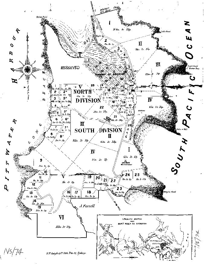
John George Cousins had a long association with the area. He was an investor in lands then brought under the Real Property Act for decades, with partners and mostly losing in these transactions, prior to being among partners buying up lots in the Avalon valley. He married a Mary Roberts in 1871. In 1884 and 1890 we find Mr. Cousins in Manly:
In the Supreme Court of New South Wales.
ECCLESIASTICAL JURISDICTION.
In the goods of Alfred Cousins, late of Manly, in the Colony of New South Wales, mercantile clerk, deceased, intestate.
NOTICE is hereby given that after the expiration of fourteen days from the publication hereof, application will be made to the Supreme Court of New South Wales, in its Ecclesiastical Jurisdiction, that letters of administration of the estate and effects of the abovenamed Alfred Cousins, who died at Manly aforesaid, on the 1st day of December, 1884, may be granted to John George Cousins, of Manly aforesaid, hotel-keeper, the father and next of kin of the deceased.—Dated this 24th day of November, 1885.
LOUIS FREDERICK DIXON, Proctor for the Applicant, 92, Pitt-street, Sydney. ECCLESIASTICAL JURISDICTION. (1885, November 27). New South Wales Government Gazette (Sydney, NSW : 1832 - 1900), p. 7682. Retrieved from http://nla.gov.au/nla.news-article223764472
Fire at Manly.
A fire broke out on Saturday afternoon (the origin of which is at present unknown) at the Steyne Hotel, Corso, Manly, licensee, John George Cousins. The fire was extinguished by the Manly Volunteer Brigade, but not before damage was done to the extent of £100. The contents are insured in several offices for £2500, and the premises in the Victoria Office for £5000. Fire at Manly. (1890, October 6). Evening News (Sydney, NSW : 1869 - 1931), p. 4. Retrieved from http://nla.gov.au/nla.news-article113742699
He also seemed to be involved in a few shady dealings and here we find Harley Mackenzie defending him:
Miniature Portraits
LOVELL, COUSINS, AND ANDREWS AGAIN ON TRIAL.
For the second time during the present sittings of the Darlinghurst Sessions, John Charles Lovell, John George Cousins, and David Andrews were, this morning, placed on trial, before Judge Doeker, and, a Jury of 12 on a charge of conspiring among themselves to cheat and defraud several persons of divers large sums of money, by passing off bogus miniature portraits as the work of old masters.
All the accused pleaded not guilty, and were defended— Lovell by Mr. Pickburn, instructed by Mr. F- Osborne (Messrs, Norton, Smith, and Company); Cousins, by Mr. J. C. Gannon and Mr. Mitchell, instructed by Mr. Harley Mackenzie (Messrs. Bowman and Mackenzie): and Andrews by Mr. Nugent Robertson, instructed by Mr. J, J. Jagelnjan, Mr. H, Harris prosecuted for the Crown. At the last trial the jury, after having been locked up all night, were discharged on the morning of the 15th instant. Particulars of the case have already been published at length in the 'Evening News.' (Proceeding.) Miniature Portraits. (1908, February 24). Evening News (Sydney, NSW : 1869 - 1931), p. 4. Retrieved from http://nla.gov.au/nla.news-article114105644
John George Cousins also passed away in 1916 and his wife had to apply for bankruptcy on his estate:
[Notice under Section-11 of the Bankruptcy Act, 1898.]
In the Supreme Court of New South Wales. (21,042)
IN BANKRUPTCY.
Re estate of the late John George Cousins (deceased), late of 278 George-street, Sydney, warehouseman.
NOTICE is hereby given that a Sequestration Order has this day been made against the abovenamed estate, on the petition of the executrix, Mary Cousins, and Mr. C. F. W. Lloyd appointed to be the Official Assignee.—Dated at Sydney, this 17th day of January, 1917.
F. H. SALUSBURY, Registrar in Bankruptcy. IN BANKRUPTCY. (1917, January 19). Government Gazette of the State of New South Wales (Sydney, NSW : 1901 - 2001), p. 413. Retrieved from http://nla.gov.au/nla.news-article226035031
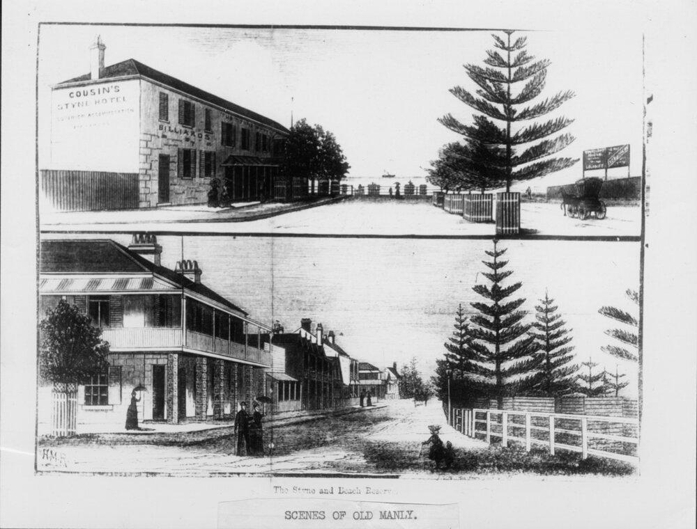
From 'Scenes of Old Manly' - the Cousins had a hotel they called 'Cousin's Steyne Hotel' at one stage (top sketch/drawing).
No. 13,259. County of Cumberland, parish of Narrabeen, 101 acres 1 rood 381 perches, situated on Clareville Wharf Road, Clareville,—is Block No. 3, South Subdivision, Pittwater Estate, and is part of 1,200 acres (portion No. 20 of parish) granted to John Joseph Therry; adjoining the properties of F. Burne, J. Robertson, S. Smith, and G. A. Smith, Trustees of Mrs. Evans, or J. G. Cousins, G. Holland, The London Bank of Australia, and J. H. Parry. – Applicant: Margaret Allan, Mosman. Day until which Caveats may be lodged: 17th February, 1905. NOTICE UNDER REAL PROPERTY ACT. (1904, December 30). Government Gazette of the State of New South Wales (Sydney, NSW : 1901 - 2001), p. 9437. Retrieved from http://nla.gov.au/nla.news-article226488010
Margaret Allan, with her occupation listed solely as 'widow', was the inheritor of two lots of Land, one at 21 perches in Little Street Mosman Parish Willoughby County Cumberland Volume 1537 Folio 192 bought under Real Property Act 1903-1904, and the 101 acres encompassed in Primary Application 13258 becomes Vol-Fol: 1636-49:
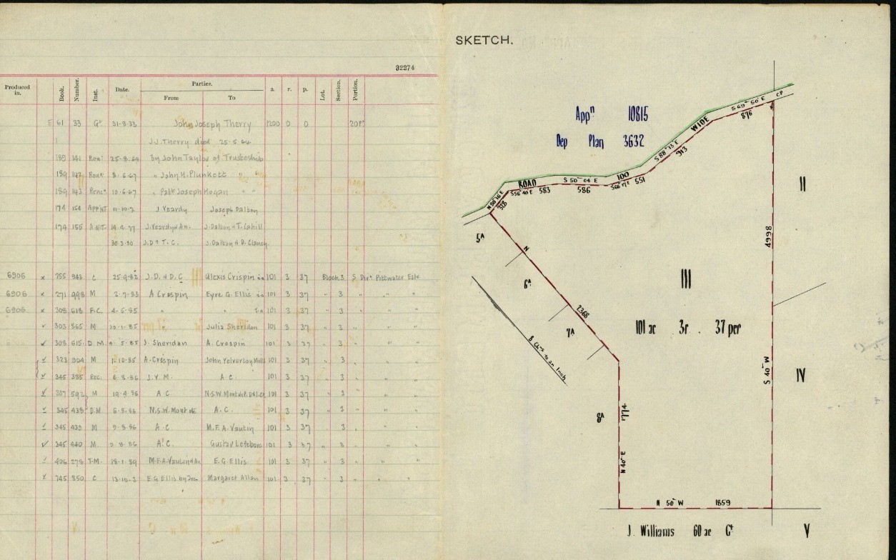
Margaret Allan leased some of this to Harry Tall 'of Clareville', Gentleman on March 1st 1911 and sold the 100 acres, 1 rood and 38 1/4 perches to George Crowley of Drummonyne, Assurance Manager, and Michael Taylor of North Sydney, Gentleman on May 3rd 1912. Their holding was registered in Vol-Fols: 2258-171 and 172.
Vol-Fol: 1636-49 shows the Land has a road running through it which is 'from Clareville Wharf' and would become named 'Central Road' and is alongside John George Cousins holding:
.jpg?timestamp=1778203653467)
.jpg?timestamp=1778203682653)
.jpg?timestamp=1778203744691)
In Vol-Fols: 2258-171 and 2258-172 it is listed that Mr. Crowley and Mr Taylor sold to Duncan Joseph McIntyre on May 12 1915 (Vol-Fol: 2597-125) and to Arthur Jabez Small, together with 'Drainage easement' on the same date, May 12 1915 (Vol-Fol: 2597-126 - was 25 acres 3 roods and one 1/2 perches as well as 35 acres 31 1/4 perches - as outline in red).
Vol-Fol: 2597-126:
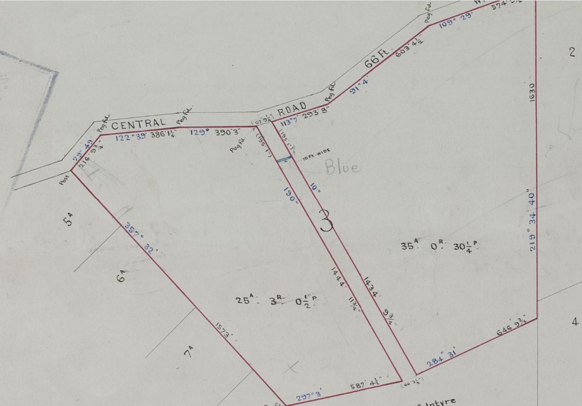
No. 18,217/ APPLICANTS:—John George Cousins, Amess Bissett Coleman, and Thomas Hardy, all Sydney. LAND: —County Cumberland, parish Narrabeen, shire Warringah, 96 acres 3 roods, on the road from Manly to Barrenjoey, being Block IV, South Division, Pittwater Estate, and part 1,200 acres (portion 20, parish), granted to John Joseph Therry; adjoining properties of F. Burne, estate late John Tomkins and A. Bowen, G. Crowley, and J M. Taylor. NOTICE UNDER REAL PROPERTY ACT. (1913, June 25). Government Gazette of the State of New South Wales (Sydney, NSW : 1901 - 2001), p. 3845. Retrieved from http://nla.gov.au/nla.news-article221596335
No. 18,923. APPLICANT: James McKinlay, Marrickville. LAND: County Cumberland, parish Narrabeen, shire Warringah, 8 acres 1 rood 12 1/2 perches, on Pittwater. near Refuge Cove,—part lot 11, Villa Sites Pittwater Estate, and is part 1200 acres (portion 20, parish), granted to John Joseph Therry ; adjoining properties of A. E. Wickham and — Kilminster. Diagrams delineating these lands may be inspected at the land Titles Office, Sydney. W. G. H-WILLIAMS, Registrar-General. 10th December, 1913. NOTICE UNDER REAL PROPERTY ACT. (1913, December 10). Government Gazette of the State of New South Wales (Sydney, NSW : 1901 - 2001), p. 7336. Retrieved from http://nla.gov.au/nla.news-article228061585
.jpeg?timestamp=1778202698947)
December 22, 1912 Advertising
No. 18,867. APPLICANT:—Mackenzie, Goulding, & Co., Limited. LAND:—County Cumberland, parish Narrabeen, shire Warringah, 10 acres 1 rood, 38 ½ perches, in William-street,—lots 17 and 13 north division, Pittwater Estate, and part 1,200 ares (portion 20, parish), granted to John Joseph Therry. NOTICE UNDER REAL PROPERTY ACT. (1914, January 21). Government Gazette of the State of New South Wales (Sydney, NSW : 1901 - 2001), p. 316. Retrieved from http://nla.gov.au/nla.news-article228096801
Watkins family of North Avalon Beach - Notes
Katoomba Police Court.
Saturday June 3rd, 1905. : , Before the P. M.
Police y Lizzie Stubbing.
This was a case in which iMrs .Lizzie Stubbins was changed that being the parent of, and having in her care seven children to wit, Josephine Stubbins (14), .Alfred Stubbins (12), Gladys Stubbins (10); Dorothy .Stubbing (7 1/2), Stanley Stubbins (5),Florrie Stubbins(3)and Edward Stubbin (2) wilfully and without reasonable excuse neglects to provide adequate food, nursing, 'clothing and lodging for the said children whereby such neglect appears likely to result in serious injury to the health of the said children.
Defendant pleaded not guilty. Alexander McDowell, senior-constable of police at Katoomba, on oath,deposed : In consequence of complaints I received went to the defendant's residence on die night of 29th ultimo accompanied by Dr. Watkins and Mr Howard, Inspector in the State Children's Relief Department; the defendant and her family had retired; knocked and the defendant called out' "Who's there" . Dr. Watkins replied "It is Dr. Watkins" ; the hut is partitioned in two and the voice come from the inner portion where I afterwards found James Lynch, half caste, and three children occupying a double bed; defendant said she had been lying there ; in the other portion which is also used for cooking there were four children; the eldest Josephine and the child Edward were asleep on a small bench in the corner; the bench was about three feet long by two feet wide; they were covered over with nothing but rags, and were sleeping in the clothes they had worn during the day; the children Alfred and Dorothy were asleep on the floor between the bench used as a table and the other children were lying oh an old straw mattress and also had the clothes on they wearing during the day; they were also covered with rags and pieces of an old blanket; asked the defendant if the children had other clothing and asked her to show it to me ; she said they had other clothes, but it was too much trouble to show them' ; opened a box which was there and saw a lot of what appeared to be children's clothing but it was more rags than anything else: the children were all in a most filthy condition; searched for food and found a bag containing a few pounds of flour, also portion of a damper and saw a tin of jam: the bed on which the children and defendant and Lynch were lying was more of a three-quarter than a double bed; there was a dog lying in the room where the three children were; and a cat ; the rooms were each about six feet and 7 feet high ; no ventilation of any kind except what came through the cracks in the walls; it was built of slabs and bark; on the -following morning laid the information which I have read and; the defendant is the person complained of ; she told me that the five eldest children belonged to her husband and the two youngest ones Florrie and Edward belong to Jimmy Lynch; on the 23rd ult. visited the defendant's camp and asked her why the children were not attending school and she said "They had not sufficient clothing"; then asked her if she would be willing to give the children over to the State Children's Department; she said "No, I will not, my mother told me never to part with them"; then told her if she did not give the children over to the state as they were not properly provided for in the matter of food and clothing I would find means of taking them from her; on the morning of the 10th ultimo sent Constables Baxter and Lisle to the defendant's camp to bring the children to the lockup which they did; the children are now in safe custody in the lockup.
By the defendant : The dog may have come in with us, but I don't think so as it appeared to come from the room occupied by the defendant.
Recalled: On the 23rd ult. I gave the defendant two government blankets for the children; on the night of the 29th ult. found the blankets being used by Jimmy Lynch ; he was rolled in one and the other was used as a sheet on the bed.
Henry Robert Lisle, police constable on oath, deposed : The first occasion I visited the defendant's residence was the 17th May in regard to the children not attending school ; asked defendant why the children were not at school and she said they had no clothes or boots ; the children were insufficiently clothed and very dirty ; the next occasion I visited the defendant was the 22nd May to see what food and blankets they had ; there were five of the children present and a young man named Locke; I asked him what food they had and he said "Nothing except a few potatoes we are cooking" ; there were three or four potatoes in a frying pan and I found no other food in the house; I was shown into a room and Locke said "These are all the blankets" showing me three on a bed ; there was also a portion of a blanket on a bunk in the next room ; defendant was not at home ; after saw her at Mrs Marx's and asked her there what blankets she had and she said "Three" ; asked her to come to the police station and she would be given a couple of blankets ; on the 28th May again visited the place and asked what food they had; found about 16 lbs flour, a tin containing about two pounds of sugar and about half a pound of tea; found the children insufficiently clothed on each occasion I visited; did not say anything to defendant about the condition of the children; knew-defendant's husband William Stubbins; as far as I know he has not resided with his wife, it is six months since l saw him there last; James Lynch has been living with' defendant on every occasion I have been to the place'.
Sydney Collins Watkins, legally qualified medical practitioner, on oath corroborated the evidence given by Senior Constable McDowell.; The condition in which I found the children would be likely to result in serious injury to their health such injury-would be permanent. I have inspected the children in question and find that Alfred (aged "12) is already nearly blind from neglect ; that Gladys (age! 10) shows signs of the commencement of the same eye condition, they arc all puny, ill-developed children, the eye condition has not existed from birth; it is caused through neglect.
Walter Alexander Howard, officer under the Children Protection Act, corroborated the evidence. He asked that the seven children be sent to the Children's Relief. Department. Defendant had no evidence to give and no witnesses. Found guilty and a fine of £2, and 7s fid costs of court in default 14 dais in Katoomba lockup. One month was allowed to pay the fine. An order was also made that all the children be committed to the control of the States Children Relief Department. Katoomba Police Court. (1905, June 9). The Mountaineer (Katoomba, NSW : 1894 - 1908), p. 7. Retrieved from http://nla.gov.au/nla.news-article190713653
Ernest's marriage records his wife is a Devenish Meares - this family also had and has connections to Pittwater, at Palm Beach:
WATKINS—MEARES. The wedding was solemnised at St. John's Church of England on Monday, by the Rev. Canon Dunstan, of Mr. Edward Sydney Watkins, only son of Dr. Sydney Collings Watkins, late of Hornsby, and Miss Sylvia Stuart Devenish Meares, youngest daughter of Mr. and Mrs. C. D. Meares, of Mudgee. The bride was given away by her father. Mr. Osborne D. Meares (brother of the bride) was best man, and Miss Joan M. Nickoll was bridesmaid. Mr. F. W. Harmer presided at the organ, and the ceremony was choral. The church was beautifully decorated by the many lady friends of the bride. After the ceremony there was an adjournment to the resi-dence of the bride's parents, where the wedding breakfast was held. Later Mr. and Mrs. Watkins left for Sydney, their future home. WATKINS—MEARES. (1920, April 8). Mudgee Guardian and North-Western Representative (NSW : 1890 - 1954), p. 14. Retrieved from http://nla.gov.au/nla.news-article157043481
Shaw Family
Rupert William Shaw. Birth: 11 January 1889 QLD, Australia. Death: 1964 Mona Vale NSW, Australia. Father: Edwin John Shaw, 1855 - 1935, married Paulina Johanna Margaret Michelina Shaw (born Ball) on May 4th 1878, at age 23 in Brisbane. Paulina was born in 1858 to Margaret Dempsey and John Ball. They had 4 children: Rupert William Shaw and Edwin Oswald Shaw (born 12/08/1883), Lionel Vincent Shaw (born 03/09/1885) and Michelina Eliza Margaret Shaw (born 14/04/1879).
Edwin was the son of James Shaw and his wife Eliza Harriet Hey. He was born in Scotland, and travelled to Australia on the "Famenoth" arriving in 1876. Some time later he returned to Scotland.
He died in 1935, but for the years in between he devoted himself to Public duty in Brisbane. Edwin Shaw was Town Clerk of the original Brisbane City Council prior to amalgamation in 1921- 1925. Prior to that he was Assistant Town Clerk. Paulina passed away on June 20 1949.
SHAW, Edwin “John”
Passed away peacefully at John Flynn Hospital late of North Casino formerly of Booyong and Mona Vale. Loved and loving husband of Jan. Adored father of Mandie, Judi, Jackie and Johnny and their partners. Loved Poppy of his 13 grandchildren and great granddaughter.
“Cast away Captain, Sail away into eternal life”
Relatives and friends are invited to attend John’s funeral service, to be held at St Andrews Anglican Church, Zadoc Street, Lismore on Monday 26th September 2016, commencing at 11am. The service will be followed by a private family cremation.
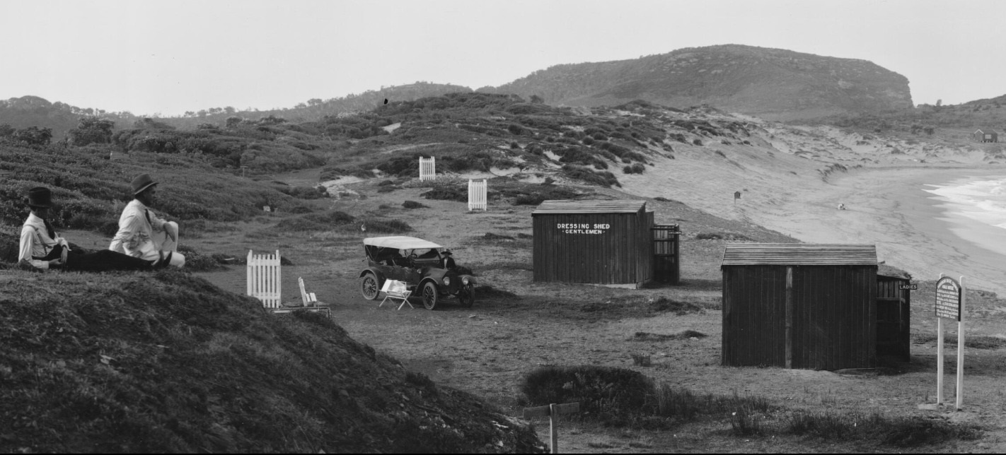
.jpg?timestamp=1675634298072)
.jpg?timestamp=1675634326944)
.jpg?timestamp=1675634351632)
'Panorama of beachgoers at Avalon Beach', New South Wales, ca. 1921-25 section enlarged to show dressing sheds on Avalon Beach at this point in time. The beginnings of Norfolk Pines, planted by A J Small are in the white wicker tree guards. Image No.: nla.pic-vn6217968 by EB Studios, part of the Enemark collection of panoramic photographs, courtesy National Library of Australia Retrieved from http://nla.gov.au/nla.obj-162503014