ANZAC Village Seniors Housing SSD to Remove almost 500 trees from Narrabeen area - allow for 1600 vehicle spaces
A proposal for seniors housing at the Anzac Village at Collaroy is currently on exhibition under the state government's State Significant Development scheme. The feedback period for residents is again two weeks - opening May 7 2026 and closing May 20 2026.
Development consent is sought for the detailed construction and operation of Stage 1, including Demolition and site preparation works, including the removal of up to 131 trees, Residential accommodation for the purposes of seniors housing and ancillary uses, comprising a total GFA of 12,712 sqm across two residential flat buildings with shared basement, and seven townhouses with building heights between two and six storeys.
The Environmental Impact Statement states 478 trees are to be removed with a canopy cover of 13,202 square metres over the whole of the stages of the project.
Stage 1 includes the removal of 131 trees with a canopy cover of 3,376 square metres, with 97 of these of High or Medium value.
RSL LifeCare lodged a $772 million State Significant Development Application (SSDA) to renew the ANZAC Village in Narrabeen, with Stage 1 focusing on a new lifestyle precinct, including a pool, gym, 95 dwellings and 122 basement car parking spaces, 14 at-grade garage spaces and 41 on-street spaces.
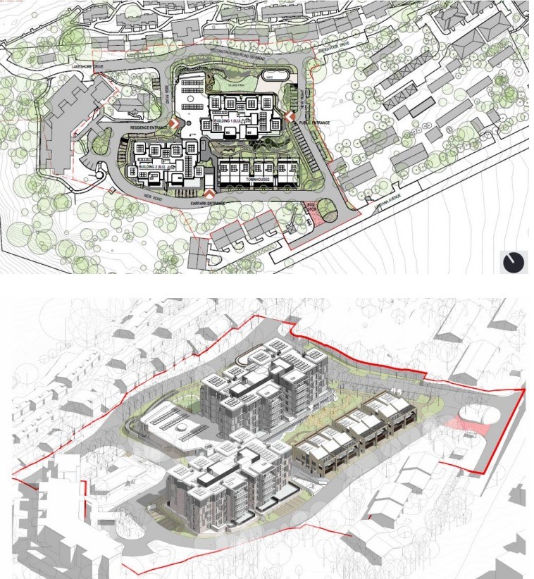
Drawing: Proposed Stage 1 area and development (site plan, above) (3D model, below)
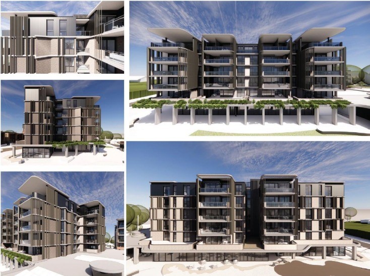
Proposed Building 1 Façade
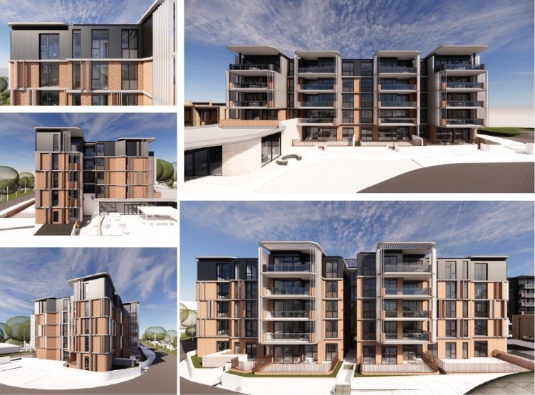
Proposed Building 2 Façade
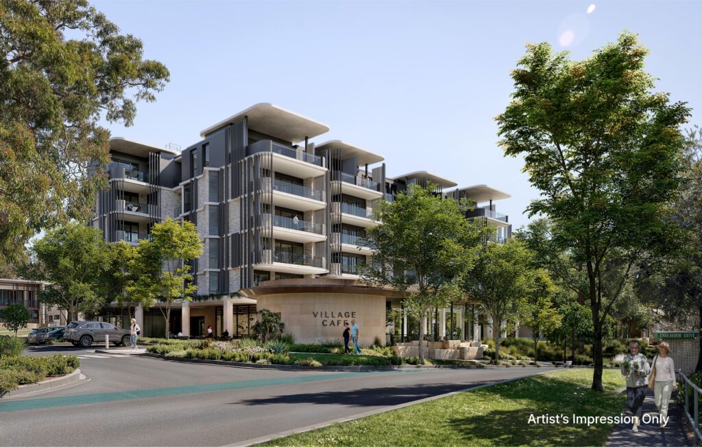
Stage 1's 6 storeys above ground works once trees have been replanted to mask height - Artists impression
The proponents state this 10-15 year project will replace old buildings with modern seniors' housing, with early construction for Stage 1 expected to commence in late 2026 or early 2027.
Stage 1 DA (SSD-85869467) is in the southwest area of the existing ANZAC Village, Narrabeen.
RSL LifeCare commenced this process in 2025.
See April 2025 report: Narrabeen's RSL ANZAC Village Renewal Project: Feedback Invited - History Insights Sought
Wildlife - Tree Impacts
The EIS states:
'An Arboricultural Impact Assessment has been prepared by CPS (Creative Planning Solutions) at Appendix V. A total of 1,669 trees were assessed within (1,355) and adjacent to the subject site (116) within the Colooli Road, Lantana Avenue and Veterans Parade street verges. Overall, as part of the proposed works, CPS recommended that 1,182 trees are retained, including nine (9) trees retained subject to root mapping investigations (to determine viability), and 478 trees be removed.'
'It is noted that the trees proposed to be removed will occur over the next 10-15 years, excluding 131 trees within Stage 1. The proposed Concept masterplan will seek to offset the removal of these trees through the implementation of a tree replacement strategy. In accordance with the Better Placed Framework, this will ensure that canopy loss is offset at a 2:1 ratio throughout the site, with 956 trees proposed to be planted across the proposed development. 151 trees are proposed to be planted in Stage 1, which equates to a replacement ratio of 1.15:1. Detailed information on the proposed tree planting regime will be subject to the future detailed DAs for the relevant stage.'
The Biodiversity Development Assessment Report - Appendix X - prepared by East Coast Ecology, determined that previous development consents and previous risk assessments have included recommendations that sections of the site shall be established and maintained as asset protection zones in accordance with the Asset Protection Zone (APZ) requirements of Planning for Bushfire Protection (BCBHS Report Section 7.03 Bushfire Protection Measures, 2026).
The Bushfire Risk Assessment Report has determined that no additional vegetation removal, beyond the trees listed in the Arborist Report, is required or recommended in the assessment.
The 10/50 clearing entitlement applies to the Subject Land. In accordance with Part 4 Division 9 of the Rural Fires Act 1997, a landowner may carry out the following vegetation clearing work on their own land:
▪ The removal, destruction (by means other than fire) or pruning of any vegetation (including trees) within 10 metres; and
▪ The removal, destruction (by means other than fire) or pruning of any vegetation, (except for trees) within 50 metres.
of an external wall of a building containing habitable rooms that comprises or is part of residential accommodation or a high-risk facility; or of an external wall of a building that comprises or is part of a farm shed. Therefore, vegetation within 10m of a habitable building within has been excluded from the assessment within the following eligible lots:
- Lot 573 / DP752038, and
- Lot 1 / DP803645.
There will be 8 hollow-bearing trees removed by the proposal outside of the APZ. One threatened species, Barking Owl, has been assumed present within the subject site. Two threatened species, Powerful Owl and Southern Myotis have been confirmed present within the subject site.
The documents state: 'Beyond the Subject Land, flora and fauna species and habitat constraints could not be directly surveyed for during the site assessment. The presence of nocturnal and cryptic species was assessed based on habitat constraints and historical records. This BDAR has not assessed impacts associated with the future 10/50 entitlement, as it expected that the entitlement will be removed by condition of approval'.
There is Sydney Coastal Enriched Sandstone Forest on the site: 2.3ha. The area Impacted by the DA is calculated at 1.18ha(0.17ha of this is exempt) + a further 0.16ha of ‘native vegetation’ and 0.38ha of planted ‘exotic vegetation – altogether 1.72ha will be impacted.
The EIS proposes avoidance strategies be implemented in the selection of tree removal within the APZ, which results in the largest tree removal throughout the site.
Avoidance measures proposed include the proponents ensure a mix of mature and young trees are retained for retention of flora habitat, as well as ongoing replacement, ensure all hollow-bearing trees are retained on the site; retain all female Allocasuarina spp. in favour of male specimens (Glossy Black-Cockatoo habitat); retain all large, high landscape significance trees, where possible; maintain a mosaic pattern (islands) of groundcovers protecting habitat for bandicoots and other species and retain tree species that are not well represented within the site and surrounds
Ultimately, the complete removal of 1.01ha of vegetation for the proposed building, proposed APZ and associated infrastructure is proposed. An additional 0.17ha of vegetation will be removed, however, this 'already benefits from the 10/50 clearing eligibility for bushfire management' the documents state.
Only the three species of the numerous wildlife and insect families known to inhabit the area are listed as being answerable for.
The EIS states: 'the following offsets are required to be secured for the proposed development:
- 15 ecosystem credits for Sydney Coastal Enriched Sandstone Forest for impacts to PCT 3592 within the site.
- 15 species credits for Southern Myotis habitat impacted by the proposed works within the site.
- 17 species credits for the assumed Barking Owl habitat impacted by the proposed works within the site.
- 17 species credits for the Powerful Owl habitat impacted by the proposed works within the site.'
For the rest, East Coast Ecology stated in their report ''the proposed works will not result in a significant impact to species or communities listed under the EPBC Act. Therefore, referral to the Minister of the Environment and Energy is not required.''
Residents would disagree. Narrabeen Lagoon is a diverse ecosystem hosting over 190 bird species, including the White-bellied Sea Eagle, Black Swan, and Little Egret. The area supports native fauna such as Swamp Wallabies, Sugar Gliders, Diamond Pythons, and various fish in its seagrass meadows. It serves not only as a crucial wildlife corridor but is home to wildlife, marine species and insects.
A little about the three species that did rate a mention as they are on their way to becoming extinct, although their extinction can be furthered towards being achieved through less than 20 species credits:
Barking Owl - Scientific name: Ninox connivens
Conservation status in NSW: Vulnerable to Extinction
The Barking Owl is medium-sized owl (42 cm, 650 g), smaller than the similar Powerful Owl and larger than the Southern Boobook. It has bright yellow eyes and no facial-disc. Upperparts are brown or greyish-brown, and the white breast is vertically streaked with brown. The large talons are yellow. Males are typically larger than their mate and have a more square crown. The quick, dog-like ‘wook-wook’ territorial call is diagnostic, but the yapping of foxes, dogs and even Sugar Gliders is sometimes attributed to this species. Pairs of birds perform call-and-answer duets, the male's tone being the deeper, which often rise to an excited rapid pitch. This species is also famous for a rarely used high-pitched tremulous scream that has earned it the name ‘screaming-woman bird'.
One photographed at Narrabeen Lagoon by John Taylor, Pittwater Camera Club, ran in September 2013, Issue 128
Pittwater Council also reported a family of the same species at Bayview in January 2016
Preferentially hunts small arboreal mammals such as Squirrel Gliders and Common Ringtail Possums, but when loss of tree hollows decreases these prey populations the owl becomes more reliant on birds, invertebrates and terrestrial mammals such as rodents and rabbits. Can catch bats and moths on the wing, but typically hunts by sallying from a tall perch.
Requires very large permanent territories in most habitats due to sparse prey densities. Monogamous pairs hunt over as much as 6000 hectares, with 2000 hectares being more typical in NSW habitats.
Two or three eggs are laid in hollows of large, old trees. Living eucalypts are preferred though dead trees are also used. Nest sites are used repeatedly over years by a pair, but they may switch sites if disturbed by predators (e.g. goannas).
Nesting occurs during mid-winter and spring, being variable between pairs and among years. As a rule of thumb, laying occurs during August and fledging in November. The female incubates for 5 weeks, roosts outside the hollow when chicks are 4 weeks old, then fledging occurs 2-3 weeks later. Young are dependent on their parents for several months.
Territorial pairs respond strongly to recordings of Barking Owl calls from up to 6 km away, though humans rarely hear this response farther than 1.5 km. Because disturbance reduces the pair’s foraging time, and can pull the female off her eggs even on cold nights, recordings should not be broadcast unnecessarily nor during the nesting season. - NSW Dept. of Environment - Listings for Species

Local photographer, John Taylor's picture of the Narrabeen Barking Owl - possibly then moved to Bayview (?)
Southern Myotis - Scientific name: Myotis macropus
Conservation status in NSW: Vulnerable to Extinction
A darling little microbat, they have disproportionately large feet; more than 8 mm long, with widely-spaced toes which are distinctly hairy and with long, curved claws. The Southern Myotis has dark-grey to reddish brown fur above and is paler below. It weighs up to 15 grams and has a wingspan of about 28 cm. They feed on aquatic insects and small fish, and so are vital in maintaining healthy ecosystems in their range. They fly close to the surface of rainforest streams or large lakes and reservoirs. These tiny bats roost in tree hollows, caves, mines, culverts and under bridges, often close to water. Sometimes they are found roosting in roofs and ceilings. Usually ten to fifteen bats, though sometimes up to 100 bats, will roost together in a colony. The female Southern Myotis's can breed just once a year and produce just one baby. Southern Myotis's are vulnerable to destruction of roost sites in caves by mining, tree hollows by land clearing/ tree-killers, disturbance by human visitors to cave roosts, changes to feeding areas by forestry and agricultural activities and pollution of rivers.
Powerful Owl - Scientific name: Ninox strenua
Conservation status in NSW: Vulnerable to Extinction
The Powerful Owl is the largest owl in Australasia. It is a typical hawk-owl, with large yellow eyes and no facial-disc. Adults reach 60 cm in length, have a wingspan of up to 140 cm and weigh up to 1.45 kilograms. Males are larger than females. The upper parts of the Powerful Owl are dark, greyish-brown with indistinct off-white bars. The underparts are whitish with dark greyish-brown V-shaped markings. Juvenile Powerful Owls have a white crown and underparts that contrasts with its small, dark streaks and dark eye patches. The call of this species may be heard at any time of the year, but it is more vocal during the autumn breeding season.
The Powerful Owl requires large tracts of forest or woodland habitat but can occur in fragmented landscapes as well. The species breeds and hunts in open or closed sclerophyll forest or woodlands and occasionally hunts in open habitats. It roosts by day in dense vegetation comprising species such as Turpentine Syncarpia glomulifera, Black She-oak Allocasuarina littoralis, Blackwood Acacia melanoxylon, Rough-barked Apple Angophora floribunda, Cherry Ballart Exocarpus cupressiformis and a number of eucalypt species.
Pairs of Powerful Owls demonstrate high fidelity to a large territory, the size of which varies with habitat quality and thus prey densities. In good habitats a mere 400 ha can support a pair when prey are dense. Where hollow trees and prey have been depleted, the owls need up to 4000 ha.
Powerful Owls nest in large tree hollows (at least 0.5 m deep), in large eucalypts (diameter at breast height of 80-240 cm) that are at least 150 years old. While the female and young are in the nest hollow the male Powerful Owl roosts nearby (10-200 m) guarding them, often choosing a dense "grove" of trees that provide concealment from other birds that harass him.
Powerful Owls are monogamous and mate for life. Nesting typically occurs from May to October, being variable between pairs and among years. Fledging can occur as late as December if a pair re-nests after a failed first attempt. Clutches consist of two dull white eggs and incubation lasts approximately 38 days.
A Bushfire Zone Site
The site is on Northern Beaches Council’s Bushfire Prone Land Map (BPLM) as containing designated Category 1 and 2 Vegetation and Vegetation Buffer. The site is therefore considered ‘bushfire prone’.
A comprehensive emergency management and evacuation plan is required, assessing current road adequacy.
Bushfire Protection Measures include:
• Improved Asset Protection Zones (increase APZs to buildings and additional vegetation management where possible);
• Reduction in occupant numbers in the non-compliant area (Removal of 81 RAC units and 5 ILUs within the BAL FZ and BAL 40 areas as shown in Figure 04);
• Redistribution of risk profile by relocating an Aged Care facility which is currently in the Flame Zone (218 RAC removed within Stages 1-5 and replaced with 399 ILUs, 7 townhouses, and 78 studios constructed to relevant BALs (maximum BAL 29) and 104 RACF constructed to relevant BALs (maximum radiant heat 10kW/m2);
• Implementation of a comprehensive Bushfire Emergency Management Plan (delivered prior to Occupation Certificate of each stage);
• Upgrade of the existing buildings for ember protection as per the ember upgrade staging strategy as shown in Figure 12.
• Nominate assembly building/s (existing or proposed) for all residents and staff that has complying APZs for new SFPP development and comply with BAL 12.5 under AS3959, (Montgomery Theatre to be used until new building is constructed within Stage 3);
• New buildings being sited in the most appropriate locations (the minimum acceptable setbacks will be to achieve 29kW/m2),
• All new construction is to comply with the relevant Bushfire Attack Level under Australian Standard 3959 ‘Construction of buildings in bushfire-prone areas’ 2018,
• The internal road network be improved to better facilitate the movement of fire appliances and other emergency services. This includes the introduction of perimeter roads adjacent the identified bushfire hazards and ensuring carriageways and curve radius of access roads within the site can support fire-fighting appliances,
• Any new roads are to strictly comply with the access requirements set out in section 6.0 of this report,
• New hydrant system sizing, spacing and pressures are to comply with AS2419.1 – 2021
.JPG?timestamp=1778707053590)
Visual Impact: High
The proposal has also assessed the Visual Impact Stage 1 may have with the EIS stating that will be High from some vantage points around Narrabeen Lagoon - Narrabeen State Park:
- Wimbledon Reserve Visual Impact Low The proposed development is largely screened by vegetation and sits below the canopy line.
- Narrabeen Street Moderate The built form is visible through vegetation.
- Middle Creek Reserve Visual Impact: High Elevated views expose upper building elements however it is mitigated by colour palette and articulation.
- Woorarra Lookout Reserve Visual Impact Moderate There is partial visibility at distance, however it integrates with topography.
- Edgecliff Boulevard Visual Impact Moderate The upper elements of the built form are perceptible but read within existing built form.
- Lantana Avenue (west) Moderate Increased built form presence at street interface however this is reduced by landscaping and setbacks.
- Lantana Avenue (east) Low The built form consistent with existing character.
- Narrabeen Lagoon Trail Visual Impact High Although the proposed development penetrates the existing tree canopy where the built form is sited, it remains within the established broader tree line when viewed from this location.
- Narrabeen Lagoon Trail – Footbridge Visual Impact Moderate Although the proposed development emerges slightly above the canopy line, it remains generally compatible with the established visual character of the surrounding context by utilising a design that is responsive to the natural environment and the vegetation remains a dominant feature of the view.
While the proposed development is visible from parts of the Narrabeen Lagoon and adjoining public spaces, its visual impact is generally low to moderate, with higher sensitivity limited to long-distance open water views, such as Middle Creek Reserve and the Lagoon Trail footbridge. Despite any deemed visual impact, the proposed development is considered acceptable from a visual impact perspective for the following reasons:
• The visual impact of the development is considered suitable in the context of the DCP, which seeks to control the scale of built development below the predominant tree line when viewed from the Lagoon viewing catchment.
• The design incorporates façade modulation, upper-level setbacks and natural materials, which reduce the visual bulk of the development.
• The established tree line remains visually prominent in long-distance views of the locality.
• Built form steps gradually with the landform to improve the direct street interface and the overarching visual amenity of the area when viewed from a distance.
As such, while the proposed development constitutes a change to the existing visual environment, this change is not regarded as unacceptable in scale, and the key characteristics of the views are maintained.
Not a 'Traffic Generating' Development
Regarding the 122 basement car parking spaces, 14 at-grade garage spaces and 41 on-street spaces, or 177 vehicles, the EIS states:
'The site does not have access to a classified road, nor is within 90m of a classified road, and therefore the relevant traffic generating activity trigger for this site and the nature of the works would be 300 dwellings. As such, the Stage 1 works are not considered to be a ‘traffic generating development’, under the TI SEPP.'
Approximately one thousand, six hundred (1600) new underground and structured car parking spaces, including street parking, will be placed on the site over the 5 stages of developments. As the detailed design of built form within the proposed planning envelopes (other than Stage 1) will be subject to future separate approvals, the proponents may continue to state the works are not considered to be a ‘traffic generating development’.
The Masterplan describes these stages as:
• Stage 1 - This first stage is sought for approval as part of this SSDA and will deliver new ILUs with a strong focus on delivering a new and upgraded lifestyle centre for the site’s residents.
• Stage 2 - This stage will form an expansion of the seniors housing offering delivered in Stage 1. The intent is to deliver new ILUs directly adjacent to the new lifestyle centre to reinforce this space as a new social centre of the Village.
• Stage 3 and Stage 3a (maintenance and staff parking) - This stage will deliver a new Residential Care Facility, ILUs and new village open space adjacent to Veterans Parade, as well as a dedicated staff car park off Colooli Road to alleviate the site from the existing at-grade car parking.
• Stage 4 and 5 - These stages will provide further ILUs with a new outdoor recreation facility (in Stage 5), designed to integrate with the site’s surrounding tree canopy.
The Anzac Village Stage 1 DA is currently on exhibition under the state government's State Significant Development scheme. The feedback period for residents closes May 20 2026.
.JPG?timestamp=1778704845729)
Signage on the steep road climbing up the hill to the Anzac Village from Narrabeen Lagoon
.JPG?timestamp=1778705182453)
.JPG?timestamp=1778707216464)
.JPG?timestamp=1778707433837)
Anzac Village Photos, May 2024, Pictures: AJG/PON
'Panoramic Photograph of Narrabeen and Collaroi Beach from West's Lakeside Estate', circa 1911 - more in Pittwater Roads II: Where the Streets Have your Name - Narrabeen
.jpg?timestamp=1749336676422)
2: Panoramic Photograph of View of Narrabeen Lakes from West's Lakeside Estate:
3: Panoramic Photograph of View of Narrabeen Lakes from West's Lakeside Estate:

.jpg?timestamp=1749338397954)
.jpg?timestamp=1749338652037)
.jpg?timestamp=1749338696434)
.jpg?timestamp=1749338730626)
.jpg?timestamp=1749338787920)
.jpg?timestamp=1749338819568)
.jpg?timestamp=1749338899367)
.jpg?timestamp=1749338935846)
.jpg?timestamp=1749338965544)
.jpg?timestamp=1749338992005)
.jpg?timestamp=1749339019924)
These photos were taken and sections and put together by the 'Exchange Studios of 49 Pitt Street'. The same firm also took panoramas of Manly during this era. The first panoramic photographs were created in the 1840s by assembling multiple images into single scenes. All panos and sections from these are courtesy of the National Archives of Australia