The South Coast Track of Tasmania
Geoff Searl’s pictures
April 4th, 2015
Earlier this week we received some wonderful images from Geoff Searl, president of the Avalon Beach Historical Society, the gentleman who is putting together a wonderful exhibition, open to the public, for the 90 year celebrations of Avalon Beach SLSC, and a gentleman many of us conferred with over what is best for our health when he and wife Colette ran Searl’s Health foods in Avalon.
When we spoke to Geoff last year for his Profile it was obvious good health and a good outlook formed the basis of his approach to life and being outdoors, revelling in the beauty of our Australian landscape, and keeping more than fit by embarking on many of the marathon walks Australia is famous for, is part of all he does. Geoff mentioned then he would be venturing to Tasmania to ‘stroll’ along the South Coast Track.
This week proof that he had arrived as well as proof that a love of photography is continued in Geoff. Many would recall Geoff's father, Ron Searl, photographed and collated many of our Pittwater events and won a prize for an image of the Warriewood surf boat in 1980.
As many would know, Tasmanians are attracted to Pittwater and settle here as it has a very similar 'feel' and landscape - so an Easter and School Holiday's special for all that focuses on this beautiful area and some words and wonderful images courtesy of one of our premier local historians!
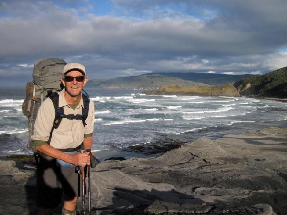
"After completing walks around the country totalling around 500kms since retirement, I had my eye on the South Coast Track, way down the bottom of Tassie." Geoff said this week
Cousin David from Ballarat had a similar desire. Diligent preparation was imperative if it was going to be successful and enjoyable. Some experiences recounted on Google were quite horrific but we planned ahead undeterred.
A Par Avion 8-seater fixed wing delivered us to the hand-made quartzite airstrip at Melaleuca Inlet on 17 March to begin the 85 km walk from west to east, the recommended direction.
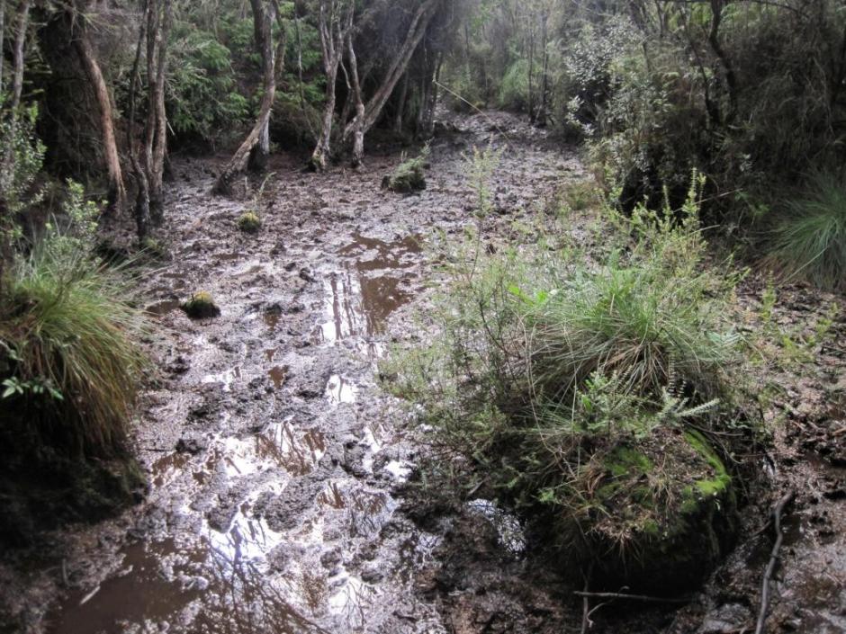
Much of the track is in low-lying button grass plains frequently covered with water except for the slightly elevated boardwalk (which at times was also covered with water!).
Day 4 was a ripper with a climb and descent of around 950 metres (equivalent to 9 Barranjoey Headlands). The summit came as a real surprise when we got hit with 95 klm per hour gusts which knocked 2 of the party of 4 off the boardwalk into the surrounding sub-alpine low scrub.
The temp. dropped to around 5 degrees Celsuis minus the chill factor and the rain drove in from the WSW - the roar of the gusts was overwhelming coming from behind and ripped my pack cover from my back, which was last seen heading for the Maatsuyker Island Group.
The descent made the climb seem like ‘a walk in the park’ with mud like I’d never seen before, incredibly steep slopes and tree roots threatening to put the skates under the unwary walker with 21 kgs on his back at any moment.
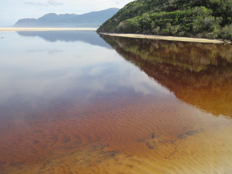
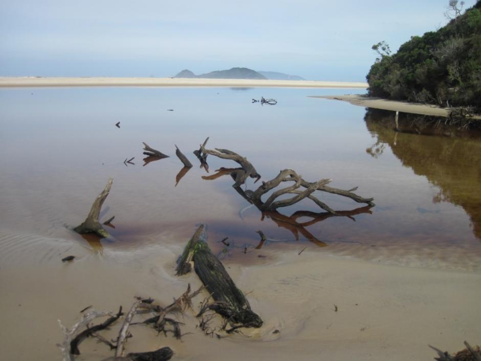
As threatening as it was it was somehow exhilarating also and the beach walks and 4 wades with ropes across stunning creeks and rivers was a fabulous experience. The water in some of the creeks tasted that good it pushed my favourite Marlborough Sav. blanc back into 2nd place.
Although we had only 2 sunny days, 3 overcast days and the remaining 4 drizzly with rain, it was the experience of the wildest of true wilderness like never before. More sunny days would have been acceptable - donning wet socks to go into wet boots at 6.30am before the sun rose wasn’t something we looked forward to.
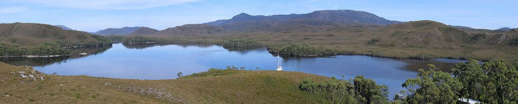
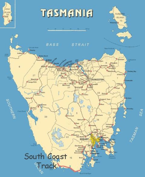 The South Coast Track is an 84 km walk between Cockle Creek and Melaleuca or between Melaleuca and Cockle Creek on Tasmania’s South Coast (if you are being flown in and then walking out), and one of Australia’s last great wilderness walks.
The walk is only for experienced hikers with a good level of fitness. Around 6 to 8 days are required and walkers must be self sufficient as there are no cafes or even huts along the way.
It remains one of the most iconic walks bushwalks and on the 'to do' list of many a proficient hiker.
The track skirts the Southwest National Park of Tasmania, beginning at Cockle Creek south of Hobart and roughly follows the southern coastline to the isolated locality of Melaleuca, which is accessible only by air, sea and foot.
Lake Pedder National Park, gazetted in 1955, subsequently delisted in 1967 although ‘incorporated’ into the Southwest National Park in 1968, is flooded in 1972, to many still forms the core of the Southwest National Park. You can read an overview of this Extinction Policy and how one of the world’s first politicised green movements began here
Ironically Lake Pedder was named by surveyor John Wedge after the first Chief Justice of the colony, Sir John Lewes Pedder.
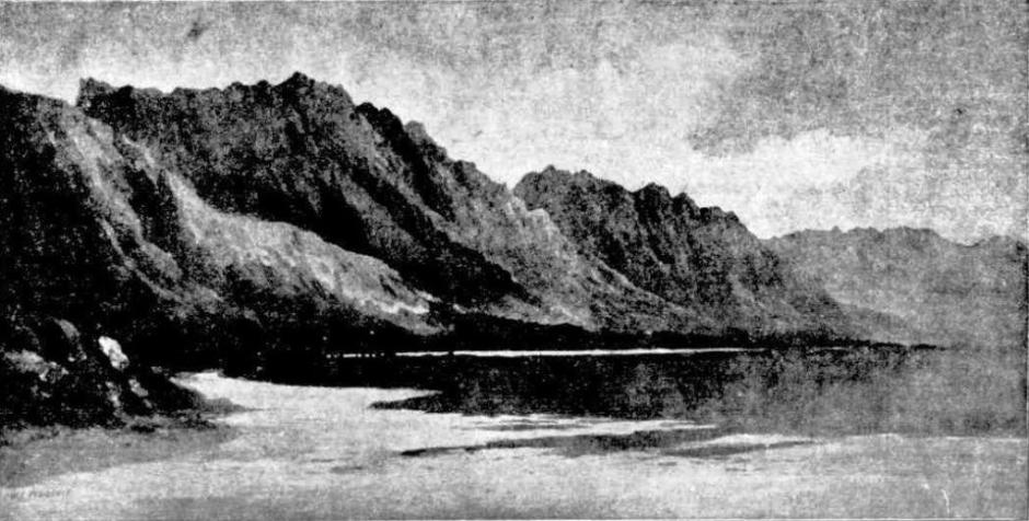
"The stillness of this secluded spot is remarkable....the most careless observer cannot behold Lake Pedder with the hundred peaks of the Frankland Range without admiration and almost amazement." James Calder, surveyor, 1837.
In 1874, Tasmanian born painter William Piguenit sketched and painted at Lake Pedder.
The Southwest National Park is a 6,182.67-square-kilometre (2,387.14 sq mi) national park located in the south-west of Tasmania, Australia and is Tasmania's largest, forming part of the Tasmanian Wilderness World Heritage Area. The park succeeded to its present size by 1990.
The eastern boundary is 93 kilometres (58 mi) west of Hobart and the park stretches to the west and south coasts. Most of Tasmania's South West Wilderness thrives here, a place famous for its pristine wilderness and remoteness and largely still untouched by humans. In the western and southern parts of the park access is only by foot, light aircraft or boat.
For those not familiar with Tasmanian weather, this place can give you a taste of those extremes of changeability, which Geoff clearly had an original taste of.
References:
REMEMBER LAKE PEDDER? By Robert Rankin - extract from the book BEYOND THE HORIZON. 2002 Rankin Publishers. Retrieved from: http://www.rankin.com.au/essay7.htm

A few Historical Notes:
EXPLORATION. SOME ACCOUNT OF THE COUNTRY
Between
HAMILTON AND LAKE PEDDER. TO THE EDITOR OF THE "DAILY MERCURY"]
Hobart Town, 9th Apnl, 1860.
SIR,-I take the liberty of offering you the following sketch of a journey recently made by a couple of friends and my self from Hamilton to the plains bordering on Lake Pedder -
The objects to be gained by this little mission were, firstly, to see how an important contract entered into by the Government had been fulfilled (namely, the re-clearing of the Gordon road for traffic, and the bridging of the Gordon River in the valley of Rasselas) and, secondly, to see whether the features of the unoccupied country, beyond that valley, gave promise that the road in question might, if necessary, be extended into the districts that are drained by the Boyd, Wedge, Serpentine, and other tributaries of the Gordon River.
I left Hobart Town on Friday the 9th ultimo, reaching Bothwell next day, and Hamilton on the following; circumstances that I need not trouble you with, making it necessary to take this circuitous route to reach the last named place. At Bothwell I was joined In Mr. McDowal and his eldest son, who, beside our carter, were my only companions; for as I have always found it most conducive to the success of my fagging foot journey, that the party should be as small as possible. At Bothwell I hired a spring cart, for which two horses were gratuitously furnished by Mr. McDowal, with which we rapidly reached the valley of Rasselas the same being the last point that horses can be driven, on the route we designed taking.
I shall not pause to describe the once flourishing, but now retrogressing town of Hamilton, which may be considered the real "Land’s End,” or point of departure of all voyageurs to the west-ward, having done so with sufficient minuteness in a recent number of the "Mercury”, where I also pointed out the causes that have led to its declension which I need not therefore repeat.
From Hamilton, Dawson's or the Gordon Road, is directed for five miles through the least interesting parts of the fine estate of Lawrenny. At this point, where we cross the Derwent, it is spanned by an excellent bridge of wood on massive stone piers. Proceeding forward to the Repulse river (13 miles from Hamilton and 57 from Hobart) we find the pastures are pretty fair, though the soil that produces them is not very captivating, nor is there anything very noticeable either In the tract of land under review or in the scenery of country around us.
Soon after crossing the Repulse river, a marked alteration takes place in the character of the surface and Its vegetation, which begins to change from pretty level and open pasture ground to heavily wooded hills on which, instead of grass we meet with only forbidding thickets, often, indeed, beautiful to the eye but repulsive of rapid settlement. The undulating surface across which the road is directed is covered with one of those astonishing and magnificent forests to which the soil of so much of Tasmania, conjunctively with the moist and genial climate of the higher lands often imparts such a wonderful character by the incredible magnitude the superior trees attain to, and the dense growth of the underwood that fills every inch of space between them. The surface is indeed very stony, but mixed with a fine red soil which the road cuttings on the hill sides shew to be of prodigious depth. It was remarked to me that the eastern faces of the hills were far less stony than those of the west. Every description of beautiful tree and shrub, which collectively constitute the ''scrubs of Tasmania”, is formed in this quarter, the most perfect and vigorous condition of growth. The sassafras,, the myrtle, the straight and gigantic mimosa, the musk tree, tea tree, laurel, currajong, waratah and a hundred other exquisite plants of which I know not the names, associated with about thirty varieties of the delicate ferns of Tasmania, make up such a forest scene, as the whole world might be searched in vain for a similar one. No description can convey to the mind any thing more than a faint idea of what such a forest really is nor does even photography itself faintly represent it. The width of this forest from east to west, which Is the general direction of our course through it, may be twenty miles " straight.” Dawson’s Road is excellent as fair at least as the Florentine River (75 miles from hence ) It is, however, a little too narrow, and is necessarily very tortuous for as it crosses the elevated watershed that separates the great basins of the Derwent and Gordon Rivers, this is an inevitable condition of successful engineering. It has been so well laid out that it is nowhere steep, though its narrowness renders it unsuitable for bullock teams but no considerable ¡inconvenience is likely to be felt from this circumstance for some years at least as the light horse cart is quite strong enough to convey all the stores that can possibly be required at the stock hut, or even the homestead of the settler during the first years of occupation. The descent into the valley of the Florentine is very considerable, yet so well has the line been managed that we were not retarded by any steep gradient, either in going or returning.
The valley, of the Florentine River contains some of the finest cultivable land of Tasmania, perhaps 30,000 acres, though this estimate is, of course, only conjectural. It is most admirably suited for settlement and I hope yet to see it all taken up under the liberal provisions of the Unsettled Lands Bill, which offers Land to anyone willing to accept it, on the reasonable conditions of personal residence on ¡t and of improving it. These conditions, however liberal they would be thought in ordinary times, seem insufficiently attractive to induce settlement on any considerable scale just at present, even in the fine vallies of the Florentine River, one person only having as yet accepted them, namely, M. Wing, who has taken 400 acres at the " Florence Bridge" (as the bridge of the Florentine is styled.) Wing Is just the man for Tasmania, and well were it for us if we could count a few thousands more of his stamp and calibre amongst our desponding population to check the restlessness of spirit that gold gambling has infected us with, and to revive the prosperity of former times. Active, ingenious, self-reliant and full of resources, no ordinary obstacles can keep such A man from going a-head, and somewhat more rapidly than the host of simpletons who (incapable of learning anything from the bitter lessons of the past,) are even now throwing all over-board to enable them to reach those newly found diggings where nine-tenths of them are destined to find delusion and ruin on the field where they are taught to believe that they will meet with nothing but the favours of fortune.
As we descend into the a valley of the Florentine River we bid adieu to the trapp and basalde formations which pervade so much of Tasmania and extend meridionally from the South Cape to the extreme Western Bluff, and laterally from the East Coast, more thanhalf way across the Island covering, (according to the observations I have recorded in a hundred journies) much about ten thousand square miles of surface. In following the course of Dawson’s road we cross Its western edge in the Florentine Valley where it gives place to it broad bed of dark colored, close grained marble, beautifully veined with Irregular lines of pure white. As it crosses the Valley of Rasselas it is overlaid by hills of white sandstone beyond which it appears again in the channel of the Gordon River. This change of rock from trapp to marble produces no change in the general character of the forest which is similar in kind and equally heavy on both; but as we approach the white sandstone hills above mentioned, the very gum trees degenerate into mere bushes, (so much has Soil to do with their expansion) and the vigorous underwood gives place to a course, miserable, and half worthless herbage. In extricating our-selves from these wretched sand hillocks we enter on the handsome and level Valley of Rasselas, (so named by Mr. Frankland in 1835) where a wide extent of open greensward forms a most agreeable contrast with the very circumscribed scenery of the close planted forest from which we have just emerged, after being pent in by it for about twenty-five miles.
It is worthy of remark that the road on the west side of the Florentine River was never properly finished, roots, stumps, and stones appearing on every yard of it, so that very careful driving is necessary to avoid a capsize. In our own case, two of us held on the cart for about ten miles to keep the centre of gravity within itself, in other words, to prevent an overset, which however, we were not successful in avoiding.
The Valley of Rasselas, which is occupied by Dr. Sharland as a sheep station, is about a mile and a half wide and several long. It is generally perfectly open, a belt, of handsome myrtles through which the Gordon flows, being nearly all the trees that grow in this Valley. The wiry and useless " gymoschenus," (the button grass of our shepherds,) is still plentiful In this valley, but it is very surprising how much it has decreased in quantity and given place to a more valuable herbage since my last visit, to this quarter in 1837.
It has been frequently noticed of the coarse marsh pastures that stocking them produces a very remarkable and beneficial change in the vegetation they produce, the feed grasses rapidly increasing and even in some measure supplanting the coarse and useless herbage. It is not only within my own recollection but it Is also recorded in my report that I addressed to the government 23 years ago, that the vegetation of the “now” grass-producing Valley of Rasselas was then just as course and valueless as that of the Denison Plains, &c., (properly 'Junction Valley') is "now." At that time it was almost literally WITHOUT GRASS, as will be seen by the following extract from the Report in question, (March,1837). " The course of this fine river, (i.e., the Gordon,) may be traced through the Valley of Rasselas by a belt of handsome forest. This plain is unfortunately of a bad description, abounding almost wholly with herbage that no sheep or cattle would touch. A little low tea tree, a little heath, and very little grass, mingled with abundance of a coarse kind of sedge, growing in Immensely large tufts, the seed of which is borne on ii long thin stem and resembles a barb..’’, &c, &c”'
The remarkable improvement that has taken place in the value of the herbage of this plain, is doubtless ascribable to the stocking of it by Mr. Wells, a few years ago. In what manlier the multiplication of the better grasses after being trodden and eaten down by sheep ¡s brought about, I shall not enquire into, but that the hateful button grass should be gradually disappearing under the operation of the processes of stocking was a fact that I was not prepared to receive, and my wits were put into perfect disorder in trying to account for the seemingly-inexplicable fact, when I learned from Dr. Sharland's shepherd that sheep which will not touch its leaf greedily devour its seed, which at once explained the means whereby its further spread was prevented. That similar causes will assuredly follow on the occupation of the open lands further west, may be expected, though the closest observation assures me, that their herbage now Is exactly similar to that of the Valley of Rasselas, as it was in 1837. 'The same immense growth of the useless button grass, which no sheep or cattle will touch, the little low tea tree and the very little grass" are the present characteristics of immense tracts that settlement has yet to reach, and which we may safely believe it will yearly Improve.
To effect this, however, it will be necessary that Dawson's road should be continued westerly, to the head of the Huon at least; the possibility of doing which at an easy cost, as far as "Junction Valley," my recent inspection of this country established; and if I cannot speak so condensely of the successful penetration of the ranges further west, I believe it is only because I had not time to examine their passes.
That same disappointment and losses which always befall the pioneer of Tasmania, will beset his first operations in these remote districts may-be reasonably expected ; but I have good reason to know that there are several who are prepared to face anything-of this kind provided that the Legislature will furnish the means to make the districts in question accessible.
It has been said before that the marshy valley of Rasselas is drained by the Gordon River, across which a cheap, but substantial, bridge has just been thrown at the public cost, whereby some very valuable pastures have been brought within the reach of settlement. This stream makes a very considerable sweep where it leaves the valley, passing out of it through its most auspicious opening through the "Thumbs" Mountains, which sweep is generally called the "Great Bend." The scenery of the wild ravine it shoots through after draining the Valley of Rasselas, is such as would attract notice even in the most Alpine regions of the world: and-the painter who could do justice to a good picture of it would, secure lasting eminence for himself by his achievement.
The landscapes of the Western districts of Tasmania are " everywhere" of the most varied kind, but if they possessed no other attractive scenes than those presented to our contemplation by the extraordinary chasms through which this fiery torrent escapes into the great estuary that receives it, namely, Macquarie Harbour,-they would even then be worth the hundred mile journey from Hobart Town to see them.
The best point from whence this extraordinary assemblage of precipices may be viewed is from the northern end of the range that lies' next westerly beyond the "Thumbs'" which I called the '"Eastclear Hills" from the fact of their eastern slopes being almost perfectly devoid of trees, contrariwise to the western ones which are covered with heavy forests, and, close-growing thickets, most difficult of penetration. It would be the highest flight of presumption to attempt to describe the landscape we viewed from this point which even the best style of painting could hardly achieve the correct portraiture of; but confining myself to the extraordinary ravine of the Gordon, I must say (however bold the expression) that even Tasmania itself has no other such remarkable assemblage of precipices as lie concealed within the narrow limits of this rarely visited ravine. These rocks are of the most in-frangible nature, and are formed of massive and water-worn quartz pebbles, so firmly cemented together that though they may be broken they are not to be separated. They overlie a bed of blue marble almost as hard and refractory as themselves.
The pedestrian travelling from Rasselas to the west, should follow near the course of the river, keeping on the ridges of its left bank about half a mile from, and six or eight hundred feet above, the stream, at which elevation he will find it pretty easy to cross the Thumbs' mountain which may be about four miles wide. This very abrupt range, like the Eastclear Hills, is most plentifully covered with masses of yellowish quartz rocks, sometimes detached and sometimes in situ, that are also-composed of boulders, which in some remote age have been separated subject to the destructive operation of water, but have since been cemented into masses of prodigious magnitudes. 'The 'villainous button grass, which is found nearly everywhere, often to the exclusion of all other herbage, is plentiful enough even on the steep slopes of the Thumbs. Having crossed this latter mountain we land in a level marsh of about 1,500 acres, whose surface Is pretty level and nearly destitute of trees. - The herbage which has not yet carried stock Is coarse and seemingly of little worth, exactly resembling that of Rasselas Valley before its occupation by Mr. Wells. Adding the open lands of the hill sides to that in the Valley, I suppose there may be 6,000 acres of it here.
As the principal difficulties of the pedestrians journey to the west commences with the scrubs on the western slopes of Eastclear Hills, we determined that future travellers should have the advantage of our passage through them. We therefore staked and "cleared" the line on which we travelled, from the lowest part of this Valley to a point about twelve miles a-head, that is, as far as the Wedge River, which lies near the eastern side of the great level which I called “Junction Valley" when I crossed it in 1837, but to which some gentle sycophant has since given the more reverential but less appropriate name of "Denison Plains". Having reached the top of Eastclear Hill, the western descent (which is far more steep than pleasant) is immediately commenced; there being no flat land on the hill top.
Of the scrubby forest we cut through, that covers the western faces of this range, I need say no more that that it is a mile through it, extending nearly from the top quite down to its base, where we reached a narrow plain about 2 ½ miles long. This plain, which forms a portion of Junction Valley, was burned by Mr. Read, of Redlands, about a week before we visited it. Though perfectly level and open, it is the most fatiguing piece of ground, of its kind, to cross that I have ever walked on. The soil being full of fibre to the depth of a foot, you fancy yourself walking on springs all the way. The surface, though covered with the rascally button grass, seems fit for little else but fuel which Read’s fires prove it well suited for, for in many places they have burned it "clear out" to the depth of a foot.
Having reached the south westernmost end of this poor plain, we enter the thick and scrubby forestswhich line the banks of the Boyd River, which are about a mile through, but so very difficult of penetration are they, and so made up of everything that is utterly hateful to those who have the faintest appreciation of things agreeable, that I named the abominable association of sludge, dank thicket, and putrefying swamps, "The Little Dismal." Midway flow the muddy waters of the Boyd through a channel pretty well filled with snags which the slow current is too powerless to remove. This forest took two of us nearly two days to cut through, thus, however, enabling future travellers to walk in about thirty minutes this single mile, which it formerly took six hours to master.
Beyond this forest commences the vast plain of Junction Valley, the level open land of which can hardly be estimated at less than twelve or fifteen thousands of acres, and which if added to that of the hills that bound it on the west, may possibly raise it to twenty-five thousands, beyond which again is a considerable extent of open hill ground. A further distance of about four miles brings us to the Wedge Riverr of which I shall have a little to say presently.
The soil of these plains is pretty fair und the herbage which is not now very prepossessing, will, I presume, improve by stocking it, which will possibly be effected next season, 40,000 acres having been selected here and about here, by the "bona fide" settlers who have lately visited lit, and who I know Intend to occupy it. Approaching the Wedge River, the surface is mostly very swampy and the huge tufts of the ever-present button grass being considerably mixed with low tea tree, the river, except at a few points, is reached with some difficulty.
The extraordinary levelness of the surface in the neighborhood of the Wedge gives to that river one peculiarity, which will ever distinguish it from all other Tasmanian streams us it is positively without appreciable motion from one end of Junction Valley to the other, which may be twelve miles. For this distance, therefore, it is nothing but a long and perfectly still pond, varying in width from 20 to 30 yards, and seemingly of very great depth. It cost me nearly two days to find a crossing place, which is over a rapid, now half-knee deep, near to its junction with the Boyd.
We camped in a handsome clump of trees on its east bank where we were kept awake half the night by the whistling of the numerous swans that resorted hither during the night in question but which quitted it, long before dawn, probably for the more expansive waters of the Lakes Pedder and Maria.
The scenery about Junction Valley is of the most varied and magnificent character, but which it would be labor lost to attempt the description of, actual inspection being essential to a just appreciation of it. The extraordinary ranges that lie along the northern horizon, and those again that shut the valley in the south and south east, are superlatively beautiful and attractive: amongst the latter, the lofty pyramid called Mt. Wedge is its conspicuous for its eminence as for its uniformity of outline.
Having crossed the Wedge, we struck out for Lake Pedder, but the time that we lost in getting over this river reduced our stock of provisions to a single day’s consumption which was insufficient for our purpose, nevertheless we pushed on and camped on the top of a high hill, twelve miles beyond the Wedge which we reached very late, and where we passed the night, without either fire or water. We were driven to this spot by the bush fires that were spreading all around us and we dare not make one ourselves sowing to the enormous growth of the dry and inflammable button- grass of the place which would have been sure to have caused us much inconvenience at least. A storm of rain subdued them next morning: it was a "regular drencher" and forced us to an immediate retracal of our steps' as it would be sure to swell the unbrdged rivers the Boyd and Wedge, which were now behind us, a condition of things we did not choose to encounter for all the lakes In the country. For myself I did not much care about revisiting Lake Pedder having been there in 1835, and again in 1837, and I should only have been glad to have done soon account of my companions. I may remark for the information of your renders that the herbage of all the hills and plains about the Lake and of the wide tract between it and the western coast exactly resembles that of Junction Valley.
…….
I remain. Sir,
Your very obedient servant,
J. E. CALDER.
* So called after its well-known engineer, who designed its course and successfully curried it out in face of difficulties positively all but insuperable.
4 Those who have seen Mr. Sharpe;s exquisite photographic landscapes, must have noticed that his "Jungle views" are not successful representations of nature; it is the “gloom” of such scenes that photography cannot paint.
* The area to be granted to any one person not to be less than 50 nor more than 610 acres, to be decided according to his means, and he is required to be possessed either of money or farm property equal to oone pound for every acre granted him.
EXPLORATION. (1860, April 13). The Hobart Town Daily Mercury (Tas. : 1858 - 1860), p. 3. Retrieved from http://nla.gov.au/nla.news-article19467349
Picturesque Tasmania - AMONG THE "WESTERN HIGHLANDS AND THE LAKE COUNTRY.
There is no portion of Tasmania of which so little is known as the ragged region lying to the west and south-west of the extreme limits of settlement in the Lake Country, nor is there any part presenting such totally different features, both in regard to form and color. Lofty and rugged mountain ranges, deep ravines, great valleys, more or less precipitous, and covered for the greater part with dense forests, and almost impenetrable scrub, and rapid rivers, liable to frequent or sudden floods, are among the chief difficulties which beset the explorer, requiring him to be stoat of heart and limb, as well as a good bushman.
Starting from Victoria (on the Huon) to Port Davey, via the valley of the Huon, Craycroft is reached. From thence, travelling in a northwesterly direction up the Arthur Plains, Lakes Pedder and Edgar are sighted; the last-named being one of the sources of the Huon. Thence the route is south westerly to Port Davey, passing between the Arthur and Franklyn Ranges. A magnificent country bursts upon the sight when the summit of the last hill overlooking Arthur Plains is reached, where the spectator sees before him a vast extent of valleys, bordered by precipitous mountains rising abruptly from the green plains, and towering up into sharp peaks against the sky, such as is never seen anywhere else than in Tasmania. The beauty of the scenery, the brightness and harmony ox
coloring, and the weird grandeur of the mountain ranges make up a pretty picture well worth seeing. The delicate tints of the rocks from pure white to silver gray or pink in the light, and a deep atmospheric blue in the shadow, make a splendid contrast with the vivid green of the button grass plain and the darker green of the timber, kept always bright by the moisture of the climate.
A closer acquaintance with the plains dispels the idea of their fertility as seen from the mountain tops, and what appears to be undulating or nearly level country is actually composed of many deep, narrow ridges and broad spurs from the mountains, covered with tussocks of button grass.
Towards Port Davey the ridges are more gravelly and the herbage shorter, the rocky hills assuming a whiter color, as if snow-clad. The plains are well watered by numerous streams of various sizes, each bordered by a belt of thick herbs and grass from 8ft to 10ft high, closely matted together; so that it is quite impossible to force a passage through it by pressing it aside. It must either be cut down or forcibly trampled under foot; so that much time is required to cross even the smallest creek. The water of the streams is of a dark brown color, owing to the peaty nature of the country through which they flow, and they seem to contain but few fish, chiefly the small native trout.
Among others, the grandest bits of scenery in the district is that known as" Hell's Gates," on the Port Davey side. The gates area chasm between two hills, whose perpendicular sides reach an altitude of from250ft to 300ft. The river in time of floods rushes through the gorge with terrible force. Continuing in a north-westerly direction you reach the southern shore of Lake Pedder, which is a fine sheet of water, surrounded by hills of a very picturesque character. The country is of a marshy nature, with numerous small lagoons dotted about.
Lake St. Clair is a noble sheet of water, surrounded for the greater part by high and precipitous mountains; but it is only by the aid of a boat that its grandest features can be seen-notably the view of Mount Olympus and Mount Ida from the north-eastern shore. The tourist on looking across the lake to the south-west sees the majestic outlines of Mount Olympus towering up before him in sombre grandeur, with the slopes at its base, covered right down to the water's edge, with a most luxuriant growth of myrtle, fern, and other trees. Turning to the north-east, a huge rampart of precipitous mountains extends for some miles along the shore, amidst which stands the isolated, bare peak of Mount Ida, with the talus at its base covered.
It is difficult, without the aid of color, to show to its full extent the features of the
mountains of the lake country, where the greenstone is the prevailing* formation, when contrasted with those ranges lying further to the south-west, such as the Arthur, and the mountains in the neighborhood of Lake Pedder, where the crystalline rocks, with their striking outlines and varied delicate tints, take the place of the dark massive-looking greenstone represented by such mountains as Mounts Olympus an<King William, and the Eldon and other ranges. A splendid view of the main portion of the western highlands can be obtained from the first peak of the Williams range. Looking over this
grand landscape he will see an apparently endless succession of deep valleys and ravines, all densely wooded, and range after range of rugged mountains all more or less precipitous. Many of these valleys, such as the Loddon for instance are clothed with the densest growth of myrtle forest ever seen in Australasia, and imparting a soft velvety green to the landscape. Numerous lakes dot the surface of the country, while gleans of alternate sunshine and shadow glittering across it give to it a variety of color, beautiful beyond compare, at one time bringing some mountain peak into bold relief and imparting to it, if belonging to the crystalline order of rock formation, the appearance of being snow clad, while others plunged in shadow are lost in the deep purpled blue of the distance ; the whole making up a scene, wild, it is true, but of such variety of form and outline, and of such wealth of color as to make the " Western Highlands" one of the most charming of the many beautiful landscapes to be found in Tasmania.
Our illustrations are from photographs of paintings by M. Piguenit, and the letterpress was compiled from his description of the tour, during which the sketches were made.
PICTURESQUE TASMANIA-AMONG WESTERN HIGHLANDS AND LAKE COUNTRY.
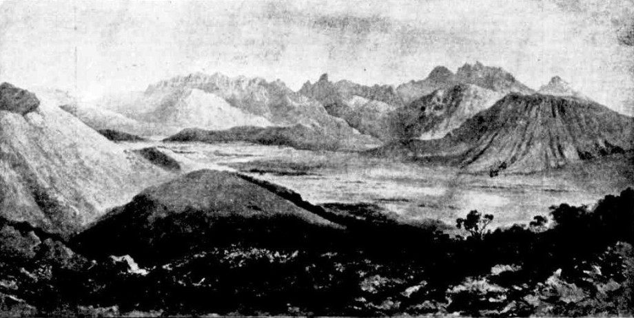
The Arthur Range.
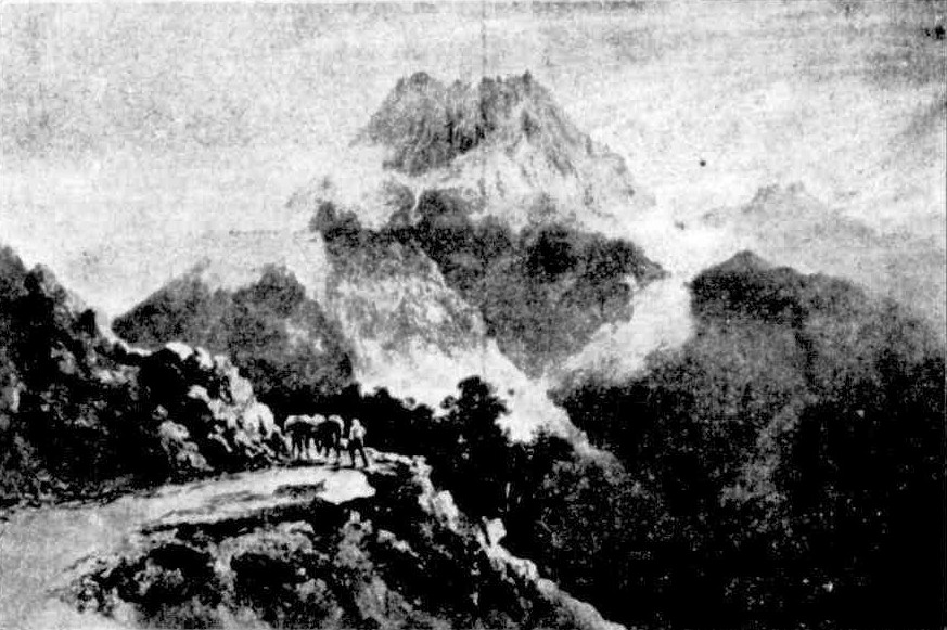
Mount Gell.
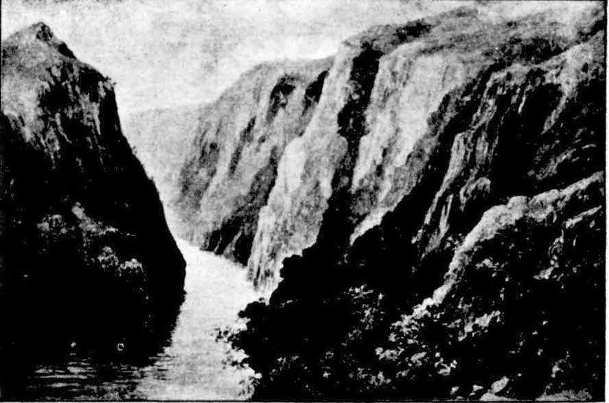
Hell's Gates.
Picturesque Tasmania. (1893, April 29). Australian Town and Country Journal (Sydney, NSW : 1870 - 1907), p. 27. Retrieved from http://nla.gov.au/nla.news-article71198441
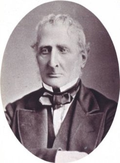 HOBART, Feb. 20.Considerable regret was manifested throughout the city, this morning when it became known that Mr. J. E. Calder, an ex-Surveyor-General of the colony, and for some years past Sergeant-at-Arms in the House of Assembly, had died suddenly at his residence, Macquarie street. There are few men in Hobart who are so well known and so generally respected, and the deceased gentleman was one of that fast diminishing band of "old identities" whose career is so interwoven with the history of the colony. It appears that Mr Calder, who was walking about with his usual vigour at the end of last week, complained on Saturday of feeling ill, but on Sunday he was up as usual. In the evening, however, he complained of great pain, and this morning feeling worse, the family sent for Dr. Bright who had been attending him. When the doctor came he pronounced Mr Calder to be better, and wrote out a prescription for him, but the doctor had not been gone more than a few moments before Mr Calder, who persisted in the opinion that he was worse, was seized with a spasm of the heart of which he died a few minutes before eleven o'clock. Mr Calder was born at Great Mailorn, in Buckinghamshire, England, on the 18th of June, 1808, and consequently would have been seventy-four years of age next June, an age which was not apparent owing to his erect carriage and keen observing eyes, and the temperate and healthy life he had led. He was educated at the Royal Military College at Sandhurst, but the intention at first entertained of adopting the Army as a profession was not carried out, and Mr Calder came to this colony in the year 1829, having received the appointment of assistant surveyor under the late Mr Sprent. While connected with the Survey Department Mr Calder was one of the most active agents in carrying out the trigonometrical survey of the island, and he has travelled over nearly every part of it. He accompanied Sir John and Lady Franklin in that memorable trip overland from Hobart to Macquarie Harbour in 1841, when the party had to sleep out in the wet for several nights, and to put up with every sort of privation. Upon the death of Mr Sprent in 1859, Mr Calder was appointed Surveyor-General and Commissioner of Crown Lands, an office he filled till 1870, when it was abolished in consequence of the creation of a Minister of Lands and Works, and Mr Calder retired upon a pension, to which was added the salary attached to the office of Sergeant-at-Arms, which he has held over since. Scarcely any man in the city was so well known as Mr Calder, and everyone liked to get an opportunity of talking to him about the early days of the colony, on which subject he was thoroughly at home, having made the history of the colony his especial study. In persuance of this study he never failed to keep a record of what was happening, and would often take a long walk to gather information about an event of the olden times from some early settler, who may be was confined to his armchair by old age, and from whom he would get the truth of some old story, and record it for future reference. From the store of old anecdotes and events he thus gathered, he would frequently furnish the press with a pithy account of some page in the colony's history, which was always read with great interest by both his contemporaries and the rising generation. He also wrote a pamphlet on the aboriginals of Tasmania, and another on oyster culture. His reports upon the various portions of the colony were all looked upon as authentic records, as he had a minute acquaintance with the geography and topography of the country, and the reports have been ordered by Parliament to be printed. Mr Calder earned the respect of nearly every one in the colony because he was so well known, and known to possess all the qualities of a gentleman, with the additional claim to respect of having done good service to the land of his adoption. Forty years ago he married a daughter of Mr Pybus, of Bruni Island, by whom he has seven children living, four daughters and three sons. The eldest living son. Mr H. Calder, is in the Education Office, and only one of his children is married, a daughter having some two or three years ago married a son of Colonel Crawford, who is in business now in the city. OBITUARY. (1882, February 21). Launceston Examiner (Tas. : 1842 - 1899), p. 2. Retrieved from http://nla.gov.au/nla.news-article38267785