May 17 - 23, 2015: Issue 214
NASA Satellite Data Helps Protect Endangered Whales
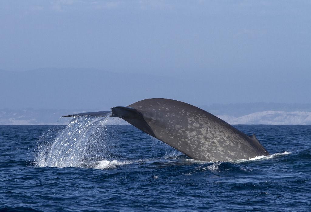
Blue whale tagged by Bruce Mate and his team off the coast of southern California, 2014. Credits: Craig Hayslip/Oregon State University
NASA Satellite Data Helps Protect Endangered Whales
May 12, 2015
Bruce Mate has been tagging blue whales since 1979. After 35 years, he has yet to lose his sense of wonder.
"The term 'awesome' is almost trite nowadays, people use it a lot. But for blue whales it's an appropriate term," said Mate, director of the Marine Mammal Institute at Oregon State University. "They're the biggest animal that's ever lived on Earth, over 100 feet long, over 100 tons in weight, and their color is a sort of iridescent blue. When you see them rising to the surface you start seeing this glimmer that keeps getting bigger and bigger. They're just amazing," he said.
A new online tool funded by NASA that helps protect this endangered species is set to be released this year by the National Oceanic and Atmospheric Administration (NOAA). The WhaleWatch tool will help decrease whale mortality due to collisions with shipping and fishing gear.
About a fourth of the roughly 12,000 blue whales in the world today live in the Pacific Ocean, said Mate. Most of them, along with other endangered whale species, migrate up and down the California coast â along with heavy fishing and shipping traffic to and from the major ports of Los Angeles and San Francisco. Massive vessels navigating through their dining areas near the ports increase the chances that a whale will be injured or killed by a collision, while becoming entangled in fishing gear can hamper a whale's ability to feed or swim to the surface to breathe.
Mate is part of a team of scientists who have created the new WhaleWatch tool that will be used to address conflicts between humans and whales based on his tag data of four whale species and satellite observations from NASA and other agencies. WhaleWatch will show for each month the most likely locations of blue, humpback, fin, and gray whales along the West Coast of the United States and Canada based on current environmental conditions detected by satellites. In addition, WhaleWatch has a daily product that will predict the movements of blue whales for any given day. The project was funded by NASA's Applied Sciences Program and is scheduled to be released on the NOAA West Coast Regional website in late 2015.
"The real way to reduce the risk of a whale getting hit is to reduce the overlap [of whales and vessels]," said Monica DeAngelis, a marine mammal scientist at NOAA's National Marine Fisheries Service (NMFS) West Coast Region in Long Beach, California, who was part of the project. NMFS is responsible for protecting endangered species like blue whales while they swim in U.S. waters, a zone that extends 200 miles from shore.
"When we sit down at the table to talk to people," including the fishing industry, shipping industry, U.S. Coast Guard, and anyone else interested in activities on the water, DeAngelis said, "the first question is where are the whales?"
In the past, NOAA has relied on boat surveys conducted from July to November during a portion of the whales' migration along the coast, but these surveys are conducted every five or so years and are just a snapshot, said WhaleWatch project leader Helen Bailey at the University of Maryland Center for Environmental Science in Solomons, Maryland. Researchers don't have the up-to-date daily, monthly, or even seasonal data on whale movements that would really inform decision-making.
That's where WhaleWatch comes in. To develop the tool, Bailey and colleagues started with 15 years of whale tag data and matched it in place and time with ocean depth measurements and satellite measurements of sea surface temperate, chlorophyll concentration and sea surface height. Bailey worked with Mate and researchers at NOAA's Southwest Fisheries Science Center, in Monterey, California, and Pacific Islands Fisheries Science Center, in Honolulu, Hawaii, to analyze the two types of data â and found patterns between environmental cues and whale movements.
On their northward migration over the summer and autumn, whales tend to stop at certain locations at certain times of the year â for example, blue whales often stop to eat their sole prey, tiny shrimp-like animals called krill.
Krill can't be detected directly by satellite, said Bailey, but satellites can detect the conditions that mean that krill â and therefore whales â are likely to be present. Krill are attracted to what are called nutrient upwellings, events that occur when cold deep water with an accumulation of dead organic matter rises to the sunlit surface. Acting like fertilizer, the organic matter full of nutrients sets off a bloom of microscopic plants called phytoplankton, whose chlorophyll are visible from space. The krill â and other marine life eaten by other whale species â come to feast on phytoplankton, bringing the rest of the marine food chain with them.
Putting all of the data together, the research team developed the WhaleWatch computer program that takes the monthly environmental data and calculates the likelihood of where whales will be present in the California Current, and then plots that data on a map. The tool isn't a perfect predictor, but the maps match up fairly well with Mate's tag data and NOAA's boat surveys, said Bailey. In addition, they show the often complex relationship between environmental factors.
"The wonderful thing," DeAngelis said, is that "to someone who might not be as familiar with this, they can literally look at a map and glean an understanding of just the complexity . . . that we're working with." The best available science is necessary to make recommendations for decisions like whether or not the U.S. Coast Guard will move shipping routes, which must balance the interests of fisheries, shipping, and recreational users with those of the whales. "Now we can share with a little bit more confidence, based on this project, that this is what we know, and what we don't know," she said.
This type of data has already helped humans adjust their movements around endangered right whales in the Atlantic Ocean, said Mate, and the early feedback the team has received from stakeholders in the Pacific has been positive.
"I don't think anyone wants to do harm to anything intentionally, but knowledge is power," said Mate. "If you don't have the information you need it's hard to make good choices."
Ellen Gray
NASA's Earth Science News Team
Last Updated: May 13, 2015: Editor: Holly Zell

Blue whale off the coast of southern California in 2014. Blue whales are among the world's most endangered species. In the first half of the 20th century, humans killed 336,000 blue whales in the Antarctic alone, reducing the population there to about 2,000 today, less than one percent of those hunted, said Mate. Credits: Craig Hayslip/Oregon State University