With the current
Wakehurst Parkway flood abatement consultation underway a few notes from previous pages
Roads To Pittwater: The Wakehurst Parkway Along Old Oxford Falls Track and
Pittwater, Narrabeen Lagoon & The Collaroy Beachfront: Some Storms and Flood Tides Of The Past, along with newfound research materials presents a
third anniversary for Narrabeen in 2021 - that of the gazettal of this parkway even though the road had commenced being used in March 1946:
MAIN ROADS ACT, 1024-1940.—PROCLAMATION,
(l.s.) F. R. JORDAN, Lieutenant-Governor.
I, the Honourable Sir Frederick Richard Jordan, Lieutenant Governor of the State of New South Wales in the Commonwealth of Australia, with the advice of the Executive Council, and in terms of section S of the Main Roads Act, 1924-1945, and in pursuance of the Transport (Division of Functions) Act, 1932-1943, do hereby proclaim that that section of the main road named and described in the first column of the Schedule hereto is by this my Proclamation given the name appearing opposite thereto in the second column of the said Schedule.
Signed and sealed at Sydney this twenty-ninth day of May, 1946.
By His Excellency's Command,
W. E. DICKSON.
GOD SAVE THE KING!
Schedule.
Description of Main Road. Name: Wakehurst Parkway.
That portion, of the Main Road No. 397 from the Warringah Shire boundary at Clontarf-road, via French's Forest, Oxford Falls, Middle and Deep Creeks, and the northern shore of Narrabeen Lagoon to Pittwater-road (Main Road No. 164) at Narrabeen. (D.M.R. No. 46-M. 53) (8327) MAIN ROADS ACT, 1924-1945.—PROCLAMATION. (1946, June 14). Government Gazette of the State of New South Wales (Sydney, NSW : 1901 - 2001), p. 1340. Retrieved from http://nla.gov.au/nla.news-article224764366
NEW SCENIC ROAD from The Spit to the north side of Narrabeen Lakes is shown on this map, compiled by the NRMA. Built by the Department of Main Roads, the road is named "Wakehurst Parkway." It is an important link in the main road system, and will assist in developing the Warringah area. Ideal picnic spots lie along the Parkway, which has five miles of bitumen, the remainder gravel. No title (1946, April 2). The Sun (Sydney, NSW : 1910 - 1954), p. 9 (LATE FINAL EXTRA). Retrieved from http://nla.gov.au/nla.news-article229459678
Prior to the building of the Wakehurst Parkway a track or road of sorts into Oxford Falls but this became a 'dead end' at Middle Creek, as evidenced in a 1912 article and an N.R.M.A. map and article which tells of spots to boil a billy alongside when visiting the Oxford Falls. This made the place perfect for early filmmakers:
Realism for Picture Shows.
RESIDENTS of Narrabeen and the Pittwater district are enjoying the exciting spectacle in their midst of stuck up mail coaches, galloping bushrangers, and troopers, beauteous heroines on horseback, and other paraphernalia of the good old bushranging days of New South Wales, while the hills around are resounding with the rifle and revolver shots of outlaws and police engaged in mortal combat on the roads, and in the neighboring bush. Alas, it is all make- believe. It is nothing more than the operations of the Australian Biograph Company, who are out on an expedition for film-making, and they have selected this beautiful and picturesque territory as a background for their pictures of Australian life and incident. - A strong cast of leading actors and actresses are engaged in the strenuous work, including Miss Harrie Ireland, Mrs. and Miss Herbert, Messrs. Gaston Mervale, Godfrey Cass, and other well-known artists. Over 40 horses are employed in the operations, which are on an extensive scale., Mr. Clarke is in charge of the camera. The company will work in the district for a week. Out in French's Forest, in the vicinity of the Oxford Falls, the Spencer Biograph Company are also engaged in the same class of task. Realism for Picture Shows. (
1911, February 1).
Balonne Beacon (St. George, Qld. : 1909 - 1954), p. 4. Retrieved from
http://nla.gov.au/nla.news-article215387874
The Oxford Falls at Manly.
Two miles from the terminus of the Manly - Brookvale tram. On the opening of the tram to Narrabeen today the falls will be brought within easy walk of the terminus. These falls, which are little known to the average residents of Sydney, are among the most beautiful scenes to be found in this part of the State. The upper fall is about 200ft crashing into a deep valley, to which access is extremely difficult. The bottom falls continue in a series of cascades, thence continuing over rugged country to Narrabeen Lake.
THE OXFORD FALLS AT MANLY. (1912, August 3). The Sun (Sydney, NSW : 1910 - 1954), p. 12. Retrieved from http://nla.gov.au/nla.news-article228826044
The area attracted hikers who celebrated its natural beauty with some early land buyers purchasing lots simply to preserve the flora species,
as was stated by Obed West. People also came to enjoy the delightful creeks that fed into the lagoon from the northern Warriewood valley, Elanora Heights and to the west, through Deep Creek, and Middle Creek.
Narrabeen Lake. A FAVORITE PLEASURE RESORT.
(See illustration on page 26).
Narrabeen Lake is one of the prettiest spots within easy reach of Sydney. It is situated six miles from Manly, being accessible by coach daily from that popular watering-place. Narrabeen is rapidly becoming a favorite resort for picnic parties and pleasure-seekers of all kinds, who are attracted there by the beauty of the scenery, which is of the character so well described by Byron in the lines:
There is a pleasure in the pathless woods,
There is a rapture on the lonely shore, There is society where none intrudes,
By the deep sea, and music in its roar.
 A great variety of ferns and wild native flowers abound in the neighborhood, and waratahs are very plentiful. The illustration is taken from the plateau - an elevated position in the fore- ground overlooking the lake. A beautiful view is obtained from here. To the left are picturesque hills and undulating vales, with their luxurious foliage and bushy undergrowth of wild vines, which flourish in tropical profusion; while here and there are huge gray rocks, whose sombre hue serves to tone down the rich colors in the scenery. To the right is a view of the beach and ocean, with a coastal steamer on her course northward. In the distance is Broken Bay, the entrance to the Hawkesbury River. Narrabeen Lake. (1890, March 29). Australian Town and Country Journal (NSW : 1870 - 1907), p. 26. Retrieved from http://nla.gov.au/nla.news-article71109744
PEEPS FROM AN ABORIGINAL GIBBER GUNYAH.
(By W. J. Walton, in 'Mankind.').
' 'Tis pleasant from the peepholes Of retreat to peep at such a world.'— Cowper.
In the late eighties the district of Oxford Falls, Middle Creek, South Creek, Wheeler Creek and the country forming part of the southern boundary of the Narrabeen lagoon, was, for all intents and purposes, in much the same virgin state as when Cook passed along the coast on his memorable voyage up north. Much of the surrounding country was wild and mountainous, very heavily timbered in places, affording some security to the rock wallabies, which, at that time, were not quite extinct. It was a land of gullies and waterfalls, having magnificent Views, of line seascapes, here and there intersected' by a number of small creeks, which, joining the main creeks, drained a great part of the watershed of the Narrabeen Lakes. In the springtime this God-made country, made joyous with the songs of birds, had a burst of efflorescence, a kaleidoscope of colour probably unsurpassed in the Australian continent.
Towards the end of the year the Christmas Bells —'Blandfordia nobilis' and 'Bland-fordia florabunda' — grew in thick patches, the nodding bells waving in the wind like the wheat in a wheat field. The Christmas Bush — 'Cerato-petalum gummiferum' — with its enlarged red sepals, came to announce that Christmas was near. Through the seasons the wealth of flowering trees and plants followed each other in quick succession; Boronia, Waratahs, Flannel Flowers, Epacris, with many others, made the wilderness of rocks and sand to blossom as the rose. Besides its wonderful flora, which, now that it is almost too late, is being regarded by the scientific world as being worthy to rank amongst the botanical treasures of the world, it contained many evidences of men, manners and customs of a bygone race.
Scratched and punctured on the naked rocks for the purposes of the native ceremonial are the petroglyphs of a primitive stone age race. Do not smile — it is from such humble beginnings that all art and culture have sprung. From a retreat where is was usual in those days of bush ramblings to spend the night, a case — a stonehouse or 'gibber gunyah' of the blades — the eye rests on what further down on the opposite side of the valley is an old aboriginal ceremony ground. Viewed at night, when the moon is obscured by clouds, it has a weird, uncanny look. The spindly trees standing sentinel on the ridge at the back of the rock saddle, look like the ghosts of the dead race.
In Governor Phillip's time there is reason to think that a great part of this Wheeler Creek area was an important aboriginal ceremony ground. Besides the principal group of rock carvings, there are spread over a wide extent of country other smaller groups, some of which after the lapse of years are difficult to locate. Many have been effaced, others are covered with soil and the encroaching bush. There are many isolated carvings scattered about, like the sacred circles, emus, fish and eels, or the large snake on a rock near the waterhole. All these to the native mind had a deep spiritual meaning.
The snake is very prominent in the many myths and legends of the Aborigines. He always lives in a waterhole. The stories about him may vary, but the intruder in his home is usually swallowed. Little of a reliable nature is known of the ceremonial life of the Aborigine in the Manly district; still, it is possible by the study of their rock carvings and customs elsewhere to get a fair insight into the daily lives of these people. The petroglyphs on the main group show they were hunters. The tracking and capture of the kangaroo are shown; there are footprints of the marsupial; following those are the footprints of men. Two kangaroos have spears in their necks. Below, a little distance on the sloping rock, are the hunters who have thrown the spears. One scene is portrayed by two men; they are having a battle royal. In the hand of each of the men is a big waddy, evidently in vigorous use. What is was all about we do not know — probably it was over a woman. Here again footprints were once to be seen: they were arranged in such a way as to indicate the progress of the battle and the flight and defeat of the smaller man. As is usual in most groups of rock carvings, the food supply is well represented. Fish, large rays and the food animals are all there. A deity without radial lines or a circle completes the group. The light side of the black's life Is represented by a number of large shells threaded on a string. In shape it resembles a large necklace. Amongst all the aboriginal rock carvings in Warringah Shire there is none like it. It is complete even to the loop by which it was held in the hand. Its use was to produce primitive music or beat time at the native dances.
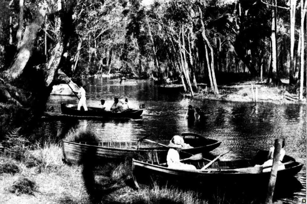
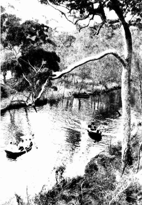
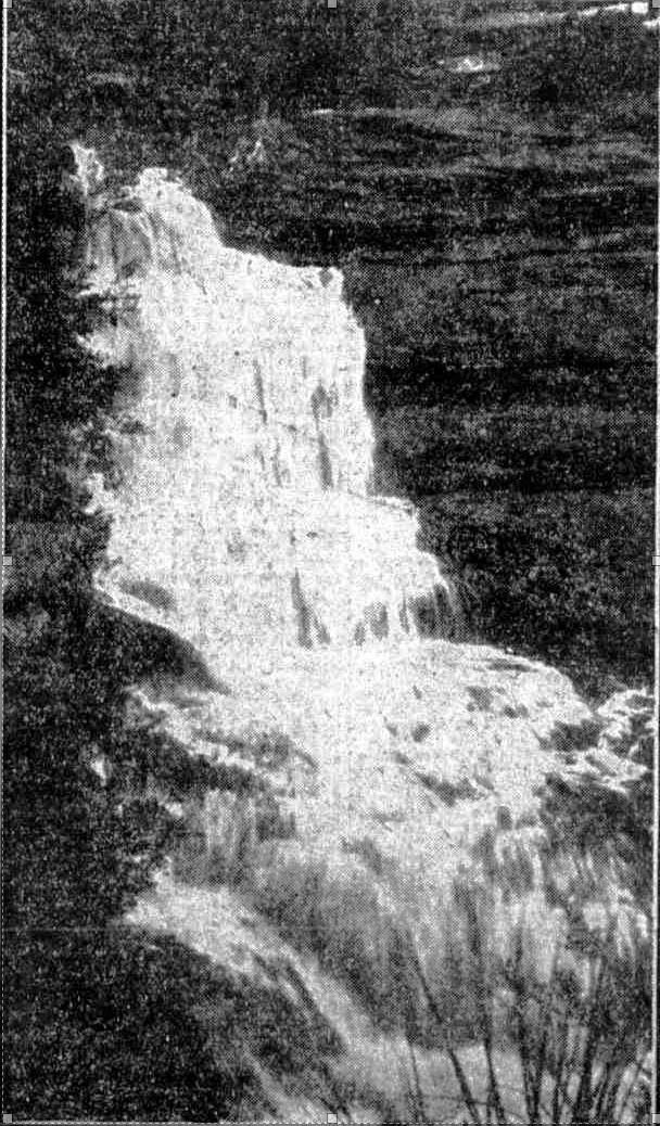
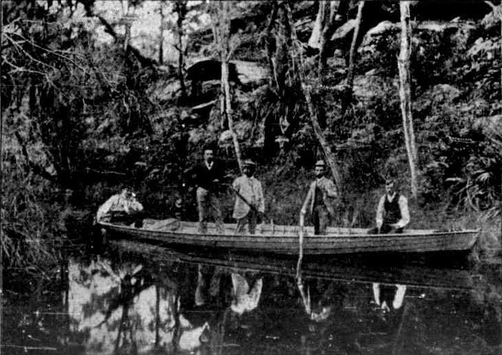
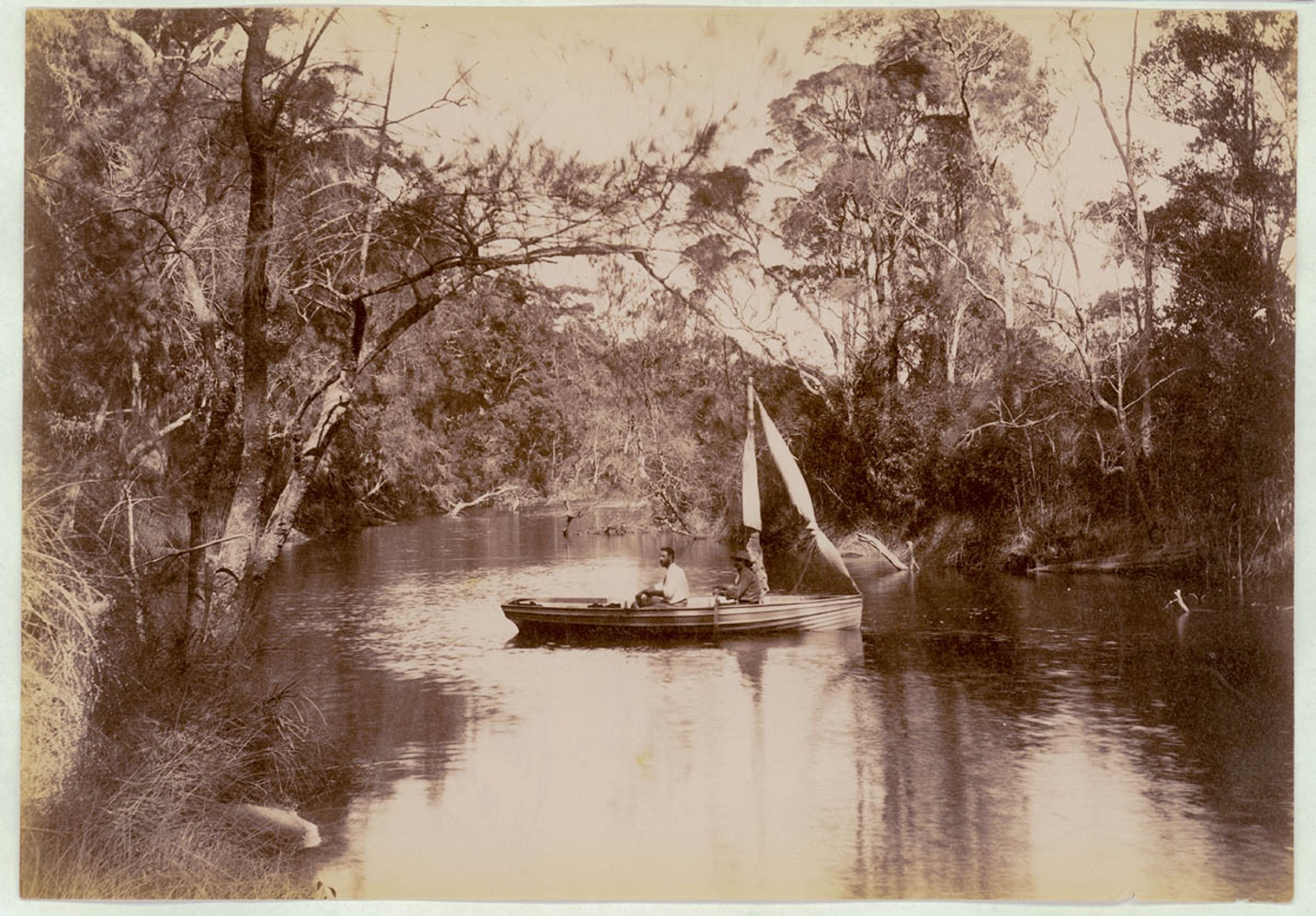
Above: Deep Creek, Narrabeen. Contemporary Journalism. (1893, November 25). Illustrated Sydney News (NSW : 1881 - 1894), p. 15. Retrieved from http://nla.gov.au/nla.news-article63672414 Below: Narrabeen Lakes, Items;No.a116487 and No.a116488, courtesy State Library of NSW
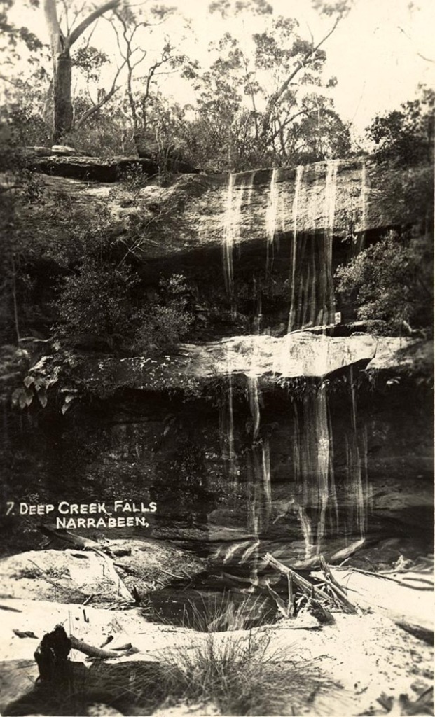
Deep Creek Falls, Narrabeen. Image No.: a106061h from 'Scenes of Narrabeen' ca. 1900-1927- Sydney & Ashfield : Broadhurst Post Card, courtesy State Library of NSW
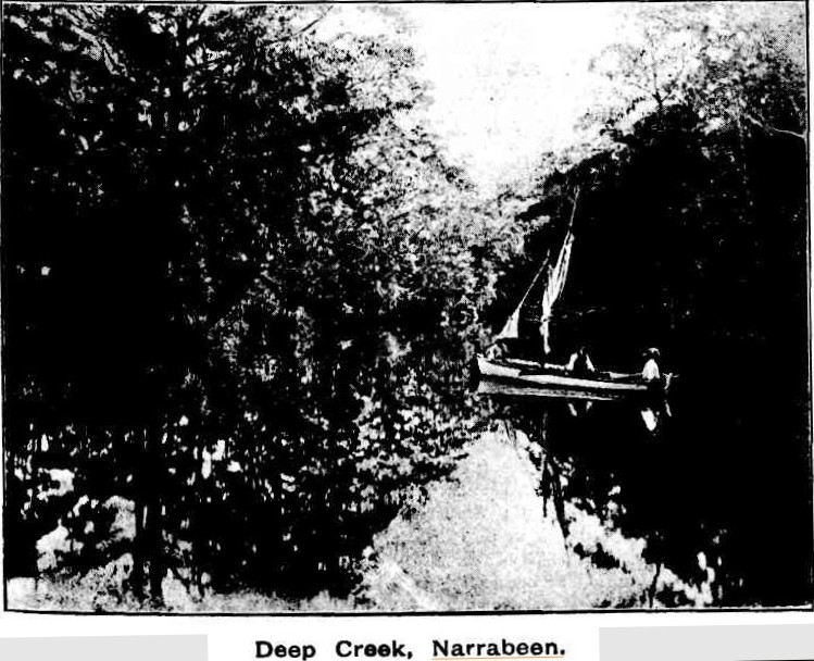
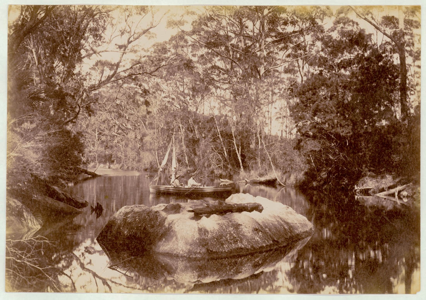
A BEAUTIFUL CREEK LEADING INTO NARRABEEN LAKE, A FEW MILES FROM MANLY. A BEAUTIFUL CREEK LEADING INTO NARRABEEN LAKE, A FEW MILES FROM MANLY. (
1923, November 14).
Sydney Mail (NSW : 1912 - 1938), , p. 11. Retrieved from
http://nla.gov.au/nla.news-article159035253
Those that lived here and those that visited would sometimes, naturally, experience floods, along with those in charge not moving fast enough to prevent these and putting lives in jeopardy thereby:
FLOOD WATERS BOUNDED BY RED TAPE
NARRABEEN LAKE COUNCIL IS HELD UP
A CURIOUS example of official red tape was revealed at Warringah Shire Council last night, when the question of releasing the flood water from Narrabeen Lake was under consideration. THE WATER, it was stated, was threatening to block traffic in the vicinity of the bridge over the lake. It was rising fast owing to the large volume coming down from South Creek, Middle Creek, and Deep Creek, and the engineer was instructed to send a gang of men to cut a channel across the beach to the ocean. MUST GET PERMISSION It then transpired that before this could be done permission would have to be obtained from the Works Department and the Fisheries Board, as the latter body controls the waters of the lake. In the meantime a large area of land is in danger of being completely sub-merged. FLOOD WATERS BOUNDED BY RED TAPE (1927, April 5). Evening News (Sydney, NSW : 1869 - 1931), p. 11. Retrieved from http://nla.gov.au/nla.news-article129074999
NARRABEEN FLATS FLOODED.
BOY SCOUTS' EXPERIENCES.
The heavy rain inundated all the low-lying portions of the district between Manly and Newport. All day yesterday anxiety pre-vailed at Narrabeen lest the lake should over-flow, for although a channel was opened out to the sea last week the heavy seas- poured the water into the lake faster than it could escape. The creeks running into the lake, Deep Creek, Middle Creek, and South Creek, were carrying great volumes of water, but when the tide receded the outgoing water was given a chance to escape into the ocean. Some cottages along the banks of the lake were slightly damaged, but no serious dam-age in that area was reported.
Many buildings in the Green Hills district at Narrabeen were flooded, and in the vicinity of Wetherill-street and Ramsay-street most of the homes were surrounded by water, and difficulty was experienced in keeping the water from getting inside the dwellings. A stable, owned by Mr. Arthur Larkin, in Wetherill-street, was washed away, and some of the gardens were four feet under water.
About 100 Boy Scouts camped at Deep Creek, Narrabeen, had an exciting experience during Friday night and Saturday morning, and they decided to strike camp on Saturday afternoon and return to their homes. During Friday night a tree fell near the scouts' tents, but fortunately none of the boys were injured.
The tramline between Manly and Brookvale was under water during Saturday morning, and traffic was held up for several hours. A channel about 30 yards wide and eight feet deep was made in the beach at North Steyne, Manly, by the flood waters from the Manly lagoon. The Manly golf links were under water, and several shops at Manly Vale, were flooded. NARRABEEN FLATS FLOODED. (1927, April 18). The Sydney Morning Herald (NSW : 1842 - 1954), p. 8. Retrieved from http://nla.gov.au/nla.news-article16370449
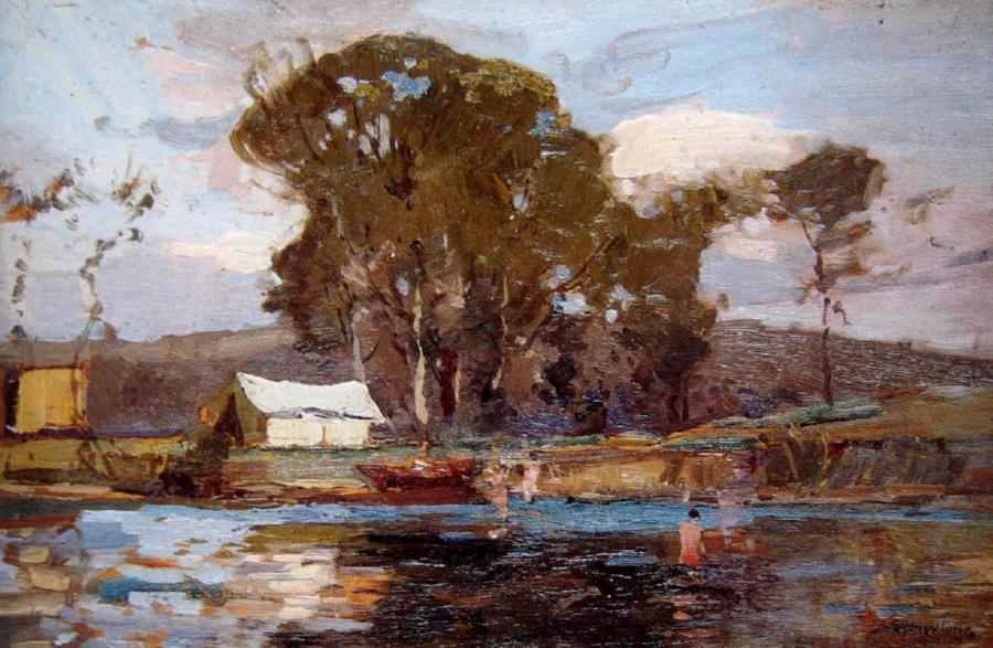
Boy Scout Camp, Narrabeen - by Sydney Long, circa post 1928 - Oil on wood panel
Decades on the 'road' still ends at Middle Creek although it makes for a nice hike according to one description:
IN THE MANLY DISTRICT
OXFORD FALLS Short Motor Tour
 Manly will be en fete this week-end and the N.R.M.A suggests that motorists visiting the district arrange their trip to Include a visit to the Oxford Falls In French's Forest.
In the vicinity of this comparatively little-known beauty spot there are ideal picnic places. The tour planned covers only 30 miles, but it includes, in addition to the falls, fine coastal panoramas and river scenery. It is suggested that the motorist from the city should cross the Harbor Bridge and proceed along Pacific Highway to Roseville, turning off to the right into Boundary-street. From the Highway it Is 2 ½ miles of good road to Roseville Bridge over Middle Harbor one of the beauty spots of the trip. Leaving the bridge, the road wind up into the forest, and, avoiding side roads, the way to the Oxford Falls turn-off cannot be mistaken. From Roseville Bridge to the turn-off is 4.4 miles. A signpost at the Junction of the roads points the way to the falls, but this should be watched for carefully, as It Is not easily visible to travellers going from the direction of Roseville.
DRIVE CAREFULLY
It is about two miles from the turn-off to the falls, and the gravel and clay road, though not difficult, requires careful driving, especially Immediately after rain. A short distance from the turn-off is a hairpin bend, which must be taken with care. From this point It is fairly easy running to the falls. The road leads to the ton of the falls, and the car should be parked just short of the creek, which forms a shallow water splash. There are really two sections of the Oxford Falls, upper and lower end, to be appreciated, a climb down to the creek, about 200 feet below the road, should be undertaken. There is no definite track down the steep and rocky hillsides, but the climb will not prove to be beyond the power of anybody of average ability. At the foot of the falls there are places where a fire may be made to boil the billy and shelter may be had In a large cave.
A DEAD END
Most maps show the road to Oxford Falls as continuing on across the creek to Join the French's Forest-road. This is not the case; the road continues for about half a mile beyond the falls, and then peters out, advises the N.R.M.A. Returning from the falls to the turn-off by the same road, the motorist keens straight ahead to the top of Beacon Hill, leading down to Brookvale. From the top of the hill there are magnificent panorama of beaches and splendid distant views of the coast. Descending the steep hill, the road to the right is taken and the tram line followed Into Manly. From Manly, the Sydney-road is taken, and a return to the city made by way of The Spit Bridge. If the motorist wishes to extend the trip, to Lake in more of the northern beaches, he should keep straight on at the foot of Beacon Hill, and follow the concrete road from the Brookvale Showground to Narrabeen. A tarred surface is passed over beyond Narrabeen to Palm Beach.
Walking Tour Series. —
-No. 6—
WHERE TO HIKE THIS WEEK-END
Dee Why, South Creek Road, Sooth Creek, Middle Creek, Narrabeen Lake Foreshores, Deep (Narrabeen) Creek, Narrabeen Lake '.Foreshores, Narrabeen
Nature of Walk: Minor roads, foot tracks, cart track, and very short stretch of main road. DISTANCE: 8 ¼ MILES
. By E. CAINES PHILLIPS
MOST Sydney folk have enjoyed several boating outings on Narrabeen Lake, and the navigable - portions - of its three "feeders," but the walk suggested here will be welcome since the aspect of a place from the. water always differs entirely from that obtained from land. Even to those who know the lake fairly well from their boating experiences on this delightful sheet of water, a walk as suggested herein will present Narrabeen Lake views entirely new to, them:
"Take a Narrabeen tram from the Manly Esplanade and alight at South Creek Road —about three-quarters of a mile beyond the Dee Why business centre. South Creek Road strikes off the main Pittwater Road (Dee Why Lagoon is seen), and a garage on one corner and a store on the other will be noticed. The road Is tarred for the first half-mile, but usually there 'Is not a great amount of traffic. Your way lies along this road, which twists and turns here 'and there for about a ;mile ; and three-quarter, until it joins a narrow road running north-south. Immediately opposite the junction with this road the St. Matthews agricultural farm for training youths will be seen, and your Inspection Is Invited.
Follow the road north through interesting bush country for about a quarter-mile and the Dee Why golf links will be seen away to the left across South Creek. Take the foot track leading from the road and across South Creek. South Creek, at this point. Is merely a narrow watercourse, and Is crossed, by rough footbridges. Across the creek, follow the southern fence of the golf links and then turn north along the western fence, thus skirting the links, avoiding trespass, and not Interfering with play. At the northern end of the links a good foot track Is followed. It leads north-east through reedy flats and swings around to the south-west at a point where It emerges to the bank 'of Middle Creek Just above Its mouth, and here Is an excellent resting spot. The track now leads. upstream of Middle Creek, and continues for. several miles right up to Oxford Falls and Oxford Settlement; but in this tour we travel along this track for only about a mile, and in this section it swings; away from the creek well into the foot of the hills; ln order to avoid a swamp on the flats. In doing so, however, it takes one to the head of a tributary stream and through a magnificent Jungle. Ferns and palms make a delightfully cool glade, through which the track passes, and soon it emerges again close to the creek bank. When you have travelled upstream for a mile (above the tidal limit, of course) cross the creek at the first opportunity to the northern bank. Here, again, one Is in delightful surroundings, and by walking down stream for a short- distance another track will be picked up, which leads direct to Narrabeen Lake near the mouth of Middle Creek. When nearing the lake this track keeps very close to the creek bank, and some- lovely views of the latter are obtained. When the lake comes into view, the way now lies north along the foreshores. Here It' is flat and open, and at the foot of the ridge between Deep and Middle Creeks Follow north to the mouth of Deep Creek, where a foot bridge will be seen. If desired, the walker may cross this, and make direct along the road to Narrabeen. but he Is advised; to. follow up Deep Creek for a mile to the tidal limit, cross It, and coma downstream on the northern bank, and so to Narrabeen. Having crossed the creek just above the tidal limit, a lovely waterfall is to be seen on a tributary creek coming in from the north. A good track will be found leading down Deep Creek (quite close to the creek), and so back to the lake. When crossing the lake, the foot, track merges Into a cart track.' and this Is then followed along the lake foreshores for about 300' yards, whence It becomes a road. The way from here Is easy — merely follow the road. : "Carefree" Jetty Is passed, and eventually one comes to the main Pittwater Road, just north of the Narrabeen bridge. Here, turn right (south), cross the bridge, and so to Narrabeen tram terminus. Walking Tour Series. (1935, August 10). The Daily Telegraph (Sydney, NSW : 1931 - 1954), p. 12. Retrieved from http://nla.gov.au/nla.news-article246600292
As with the raison d'etre for many other roads, connections for a growing demand for housing development was a main factor in the construction of this thoroughfare. At this time, 1929, and just weeks after Black Tuesday, the stock market crash of October 29th on Wall Street through which billions were lost, talk about a railway from Gordon to Narrabeen, alongside the fairly rough Mona Vale Road, was still part of the aspirational discussions.
REAL ESTATE
NORTHERN PLATEAU.
A Land of Promise.
Known to-day. as the "Harbour City," there Is no reason why Sydney should not be styled more appropriately the "City of the Harbours." Already the waves of population, to reverse the usual simile, are lapping the shores of four havens-Port Hacking, Botany Bay, Port Jackson, and Middle Harbour-and the more adventurous wavelets touch the Pitt-water and Brisbane Water. There will be intensification of settlement in the central and southern areas, but the National Park will break the line of coastal advance in a southerly direction, and the northern region must exercise its spell.
Leaving the further shores of the Hawkesbury estuary out of the picture, and concentrating on the plateau lying between Middle Harbour and the Pittwater, it might be asked, Where in the world in close proximity to a great city can such a delectable area be found?
Stand on Beacon Hill, Just behind Brookvale, or on Elanora Lookout, or at The Pines, at the back of Narrabeen Lagoon, on a fine day, and it will be agreed that before one a panorama of exhilarating loveliness is spread. From South Head to Barrenjoey a succession of bold headlands interspersed with golden beaches, lagoons, and lakes, unfolds itself. All around in its primitive beauty is the Australian bush, and the air is balm to constitutions vitiated by existence at low altitudes. A land fit for heroes to live in if heroic enough to handle it reverently.
THIRTY MINUTES FROM TOWN.
As the opening of the Harbour bridge will bring the northern plateau within half-an hour's journey by motor from the city, its desirability as a place of residence is already becoming recognised. In the estimation of surveyors the plateau lends itself easily to subdivision into modern residential areas. A glance at the model at the offices of the Water and Sewerage Board shows a deeply indented plateau, with ridges in the back region running, generally, north and south. Towards the coast the formation is less regular, becoming almost chaotic, Indeed, in the vicinity of the Narrabeen lakes, but offering facilities for effective treatment. The area is served by two main arteries, the Gordon-Pittwater-road, traversing the main ridges to Newport, and the road from Roseville bridge through French's Forest, which at present is being relocated and improved. The Pittwater-road, skirting the coast, is also being widened and modernised.
Much of the plateau land has been alienated, but here and there are areas of Crown land aggregating 13,000 acres in the shire, exclusive of reserves for recreation or other purposes. There are in the parish of Narrabeen about 1600 acres between Tumbledown Dick and Church Point, fronting McCarr's Recreation Reserves, and 5400 acres known as Duffy's Forest in the parish of Broken Bay, between Pittwater-road and Kuring-gai Chase Further, there are 260 acres situated to the east of First Rocks, in the parish of Manly Cove, between Pittwater-road and Davidson Park, and 2500 acres in French's Forest, between French's Forest-road and the same reserve. Various areas, including Oxford and Middle Creek, totalling 2600 acres, extend from the neighbourhood of French's Forest road to Narrabeen Lagoon, while there are 300 acres in the Brookvale district. Inclusive of the half of Kuring-gai Chase which lies within Warringah Shire, there are about 18,000 acres in the shire devoted to reserves.
The plateau is at present practically empty, and it is significant that land is still quoted by the acre in most localities. It is also well held. An offer of £12,000 for 150 acres near The Pines failed to tempt the owner. In general in the coastal region values run from £75 to £200 an acre. With the price of land in the fashionable eastern suburbs around £70 a foot it may readily be seen that it would be less expensive to buy an acre or two and build a good-class house in this region than to acquire land and build at, say, Darling Point.
MODERN PLANNING DESIRABLE.
In that such a vast area is held by the Crown, and, comparatively, but few private owners, this region would seem to call for treatment on modern lines. Sydney has seen much of her beauty frittered away by hap-hazard layout and "development" of a sordid character. Here an opportunity presents itself for regional planning on lines which will be profitable to the Individual and the State. The way has been shown by the company which has laid out Elanora Heights, a portion of this terrain, to great advantage, and another plan for an estate on sound town planning lines was outlined in these columns n August. There is room for the inauguration of a number of schemes if the Crown, private owners, and the different societies interested In regional planning would work In co-operation In carrying them into effect; There is ample room, even, for those re-formers whose Ideas clash to put individual plans into practice.
As is demonstrated in the adjoining column, Germany has put regional planning schemes into effect, to the mutual advantage of Crown and people in urban areas which were as ugly as many of Sydney's suburbs. Two years hence, or earlier If present Indications do not mislead, many now resident south of Port Jackson will trek north, so little time remains to arrange matters that they will settle in an area so adapted to occupation that they will enjoy all Its amenities and get the best out of life. REAL ESTATE NORTHERN PLATEAU. (
1929, November 27).
The Sydney Morning Herald (NSW : 1842 - 1954), p. 13. Retrieved from
http://nla.gov.au/nla.news-article16605504
Although not commenced until the year World War II also began, rapid progress was made during the first few years:
NEW ROAD TO NARRABEEN.
Start on Monday.
WORK FOR UNEMPLOYED.
The construction of a new road from The Spit through French's Forest to Narrabeen will be begun on Monday morning by the Department of Main Roads.
The road, for which the name Warringah Highway has been chosen, will start from a point in the vicinity of the Dalwood Homes, at the top of the hill on the Manly side of the Spit Bridge, and when completed will considerably shorten the Journey from the city to Narrabeen, and relieve the heavy week-end traffic on the existing roads.
The Minister for Labour and Industry, Mr. Gollan, said last night that about 200 men would be employed on rationed work on the construction of the new highway, and it was expected that it would take about two years to complete. NEW ROAD TO NARRABEEN. (
1939, November 25 - Saturday).
The Sydney Morning Herald (NSW : 1842 - 1954), p. 17. Retrieved from
http://nla.gov.au/nla.news-article17619360
NEW ROAD TO NARRABEEN
Rapid progress is being made with new cross-country road designed to provide more speedy access to the city for residents of the northern end of Narrabeen Lakes and Palm Beach.
The Assistant commissioner for Main Roads (Mr. Craig) said to-day that the project had been started to absorb unemployed and was being carried out as a relief work. Nearly three-quarters of the work has been done, and the date of completion will depend on the number of men retained on the job. The road will be about seven miles long and will give direct connection between The Spit and the northern end of Narrabeen Lakes. At the northern end of the lakes, the road will join the existing route to Palm Beach just beyond a bridge that crosses the Narrabeen Lagoon. Bitumen will later replace the present gravel surface. NEW ROAD TO NARRABEEN (
1940, November 12).
The Sun (Sydney, NSW : 1910 - 1954), p. 4 (LATE FINAL EXTRA). Retrieved from
http://nla.gov.au/nla.news-article231157936
NEW ROAD TO NARRABEEN.
In a recent official report received by the N.R.M.A. concerning the new road being constructed from Dalwood Homes near Seaforth to Narrabeen by way of Oxford Falls, it is indicated that except for two short sections the formation is completed from a point one mile beyond Dalwood Homes to Narrabeen Lake at Middle Creek, a distance of approximately six miles.
Gravelling of the pavement has been carried out for a length of four miles. A number of bridges have yet to be built, and it is likely therefore that it will be some time before the road is available for through traffic. A NEW ROAD TO THE NORTH. (
1941, August 26).
Macleay Argus (Kempsey, NSW : 1885 - 1907; 1909 - 1910; 1912 - 1913; 1915 - 1916; 1918 - 1954), p. 6. Retrieved from
http://nla.gov.au/nla.news-article234472278
There was already a bridge of sorts at Deep Creek.
STRUGGLE IN WATER
Picnickers Rescue Woman
A woman fell into the water near Deep Creek Bridge, Narrabeen Lakes, late yesterday afternoon, and was rescued by a picnic party, one of whom was Mr. John McLean, senr., of the Narrabeen Post Office.
Mr. McLean and the other members of the party were rowing in the lake when they saw a man and a woman struggling in the water. The rowers pulled over to them, but the man jumped out of the water and went away. The woman was helped ashore. On the arrival of Constable Hamer she was taken to the Manly Cottage Hospital, and this morning was able to leave the institution.
NARRABEEN LAKE.
Mining Lease Applied For.
LOCAL PROTEST
It was stated at a conference between Warringah Shire councillors, local residents, and representatives of public bodies, at Narrabeen on Saturday, that In addition to a dredging lease having been granted for Narrabeen Lake, an application had been lodged for a mining lease on the sand spit at the entrance to the lake.
Mr. F W. Heaton, an ex-Mayor of Manly who stated that the proposal in the first Instance was to dredge a channel 200ft wide from the entrance to the head of the lake, said he lodged a caveat against it as he knew it would destroy the lake, the bed of which was a couple of feet above the ocean. He had no objection If the dredging was confined to the part above the bridges, and an agreement to that effect had been signed. He read a letter from the department, which intimated that Industries and Cements. Ltd. (the company concerned) had been Informed that no mining or dredging operations could be carried on between the two bridges until tide gates had been erected at the entrance to the lake.
' I have lodged an objection to the implication of Edward Garland Stone for a mining lease of four acres of land on the sand spit at the entrance to the lake," Mr H S Harvey, a local resident, stated. He said there was a bar of rock at the entrance, which should only be interfered with by a Government department.
"If the lease Is granted" Mr Harvey stated "the Act allows the lessee to erect any building or machinery, and he could take or divert any stream flowing through it and use the water for mining or domestic purposes "
Mr. A. J. Small (acting president of the Parks and Playgrounds Movement) said that to Interfere with the lake would be a crime against the public. It was one of the beauty spots of the State. The proposal was now to industrialise it, and make it a second Botany Bay. A request had been made to the Government for £14,000, to purchase the land around Deewhv Lagoon and at Narrabeen they had a lake infinitely more beautiful. The safety of it for children would be destroyed just to get a very limited supply of sea shell for cement.
Mr. Edward Giles Stone, speaking for the company concerned, said there was a misconception about the whole matter. The original lease was for the area between the bridge and the side of the cement works at Deep Creek. This had received the unanimous approval of the shire council. Later they found that the bulk of the shell was between the two bridges, and when objection was raised to dredging there, they agreed to erect tide gates. They did not Intend to mine on the spit, or to move a bit of sand from there. They were prepared to abandon the application for the mining lease if they were allowed to build the tide gates
Mr. Small: I am astounded that the council should agree to commercialise this area. If the council compromises, we will tight to get the departmental decision reversed.
Councillor Austin (president of the Warringah Shire) stated that the matter of the mining lease would be brought before the council. NARRABEEN LAKE. (
1934, November 12).
The Sydney Morning Herald (NSW : 1842 - 1954), p. 10. Retrieved from
http://nla.gov.au/nla.news-article17138905
Mr. Stone's bridge at Deep Creek.
WATER SHORTAGE
Sir,-The definite engineering fact that stands out is that only an early start with and ultimate completion of the Warragamba reservoir can materially assist the position. If no rain comes, then nothing that engineers can do with large constructional work can add one gallon to the existing storage. In spite of a full knowledge of the Snowy River and all it means, the Water Board still adheres to the necessity for building first the Warragamba. I must agree that this is sound and in accord with the following facts:-(a), the Warragamba project can be completed in one half the time any other permanent scheme requires; (b), the materials employed In the construction of the dam arc all available and will not weaken our war , effort; (c), the labourers required are very few of them specialists. The mixing and placing of concrete can be carried out by men who are readily trained; (d), at an early stage in the ...nearby existing dams; (e). practically all the Initiatory work is completed and the money has simply to be allocated and the work started; (f), the board's engineers, who are at least equal to any in the world, especially on Australian proposals, have conclusively proved the soundness and sufficiency of the scheme.
Let the board proceed with the Warragamba at once; the Snowy River scheme is useless because of the time factor.
Narrabeen. EDWARD G. STONE.
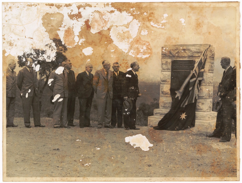
On Friday March 22nd, 1946:
Official Opening of Wakehurst Parkway. Opened March 22nd, 1946 - Alderman J. Anderson Mayor of Manly, Mr E.D. Darby M.L.A, Mr H.M. Sherrard Assistant Commissioner for Main Roads, Mr S.A. Storey M.L.A, Mr F. Laws Metropolitan Engineer, Department of Main Roads, Councillor W.L. Harris, President Warringah Shire, Honourable W.J. Mc Kell M.L.A, Premier of NSW, the late Mr D. Craig formerly Commissioner for Main Roads, Honourable M. O'Sullivan, M.L.Q Minister for Transport, Mr L.A. Robb Official Secretary to the Governor of NSW, Mr... - courtesy State Archives and Records NSW. Also available via Mitchell Library, State Library of NSW. Image No.: Government Printing Office 1 - 37800, dated 2/1946.
NEW ROAD LINK WITH LAKES AREA
A new road, officially opened last weekend, from the top of The Spit hill to the north side of Narrabeen Lakes, will provide a fine scenic drive for motorists, reports the N.R.M.A.
Constructed by the Department of Main Roads and officially named "Wakehurst Parkway" the road runs from Seaforth past Dalwood Homes to Roseville Bridge -Dee Why road in French's Forest, thence to the main Palm Beach road, which it joins immediately north of Narrabeen Lakes. The new road will form an important link in the main road system and, when public transport has been instituted, will assist materially in developing the Warringah area from Narrabeen to Hawkesbury River. Ultimately a new bridge will be constructed at The Spit with an improved approach connecting with the new road. NEW ROAD LINK WITH LAKES AREA (
1946, March 31).
Truth (Sydney, NSW : 1894 - 1954), p. 20. Retrieved from
http://nla.gov.au/nla.news-article168768869
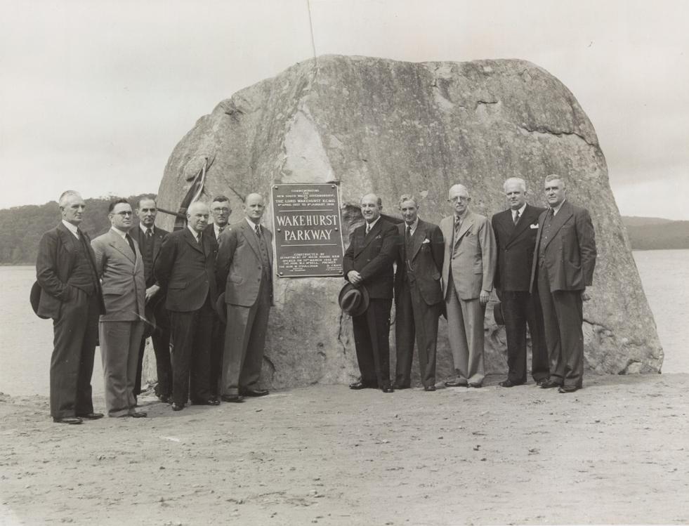
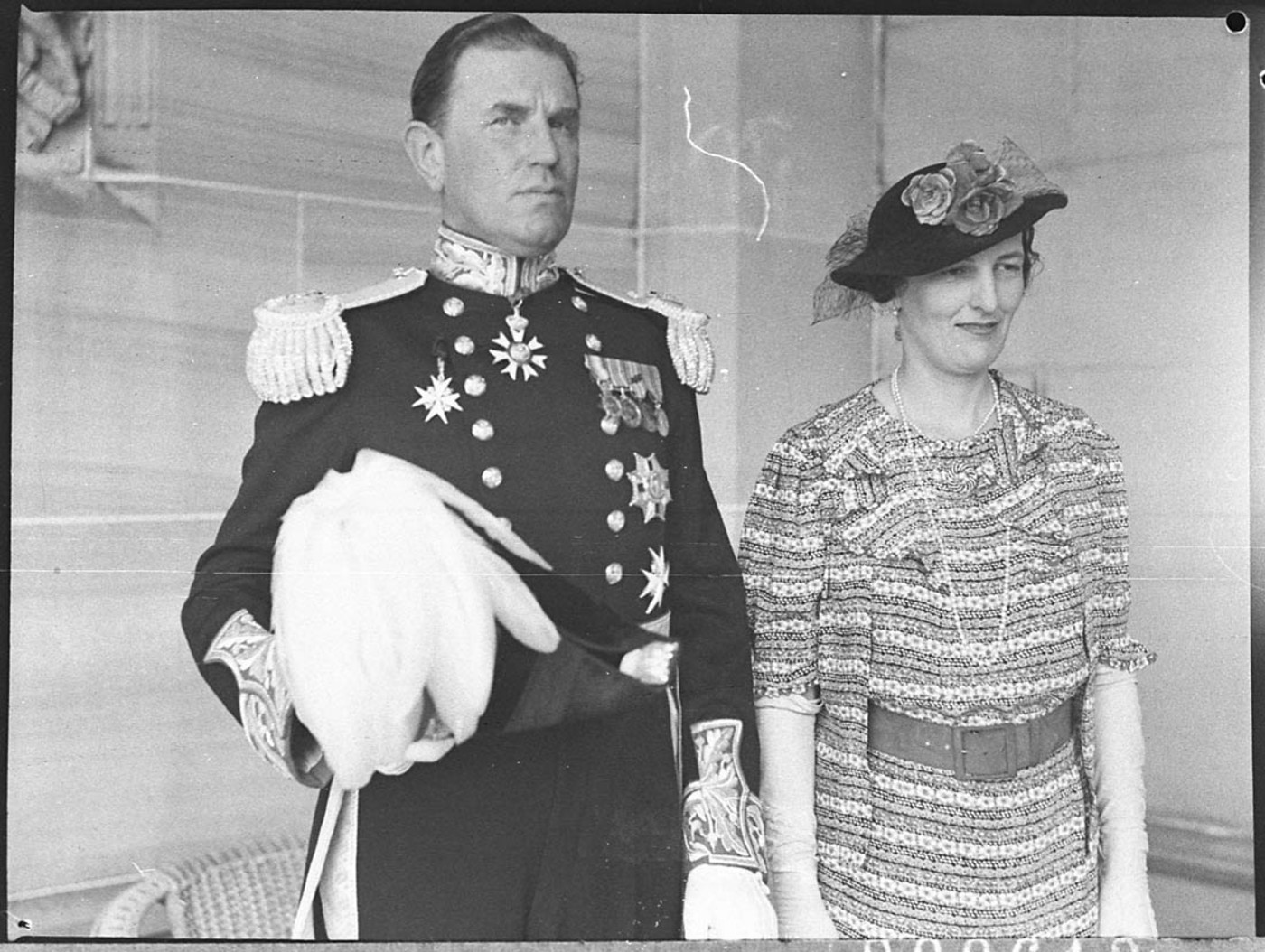
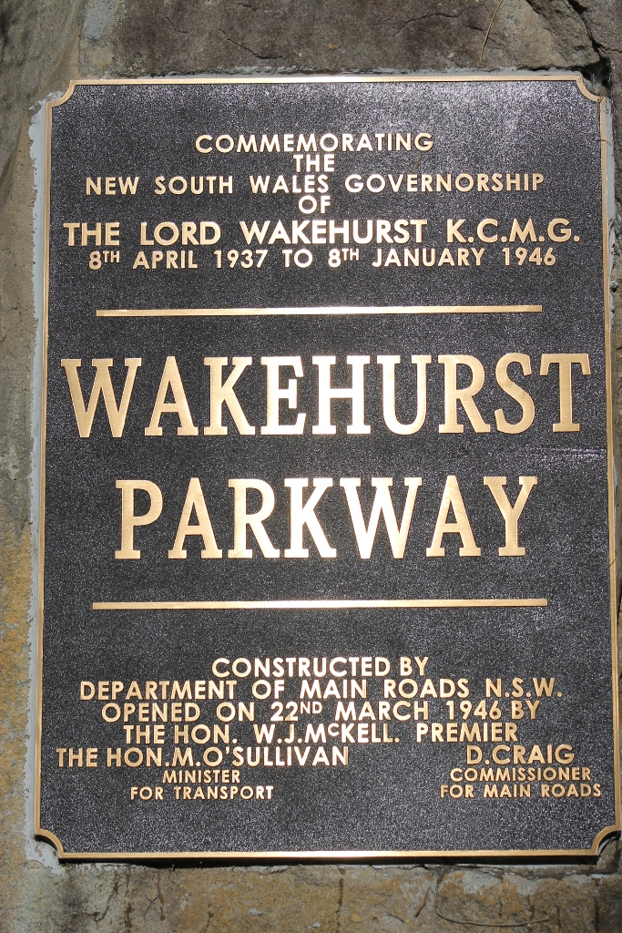
The Wakehurst Parkway was named to commemorate the governorship of New South Wales by Lord Wakehurst from April 1937 to January 8th 1946 —then a record term. He was succeeded by (Sir) John Northcott, and was the last non-Australian Governor of New South Wales.
WAKEHURST PARKWAY .
The new main road from Seaforth to Narrabeen was formally opened to traffic and named the "Wakehurst Parkway " by the Premier, the Hon . W . J. McKell , M.L.A. , at a ceremony on the roadside, on the 22nd March, 1940. A commemorative tablet was unveiled by the Premier near each end of the new work.
The naming of the road is an expression of the Government's desire to pay tribute to Lord Wakehurst, who, as Governor of New South Wales from April 1937 to January 1946, took a great interest in the development o f the State and in its natural beauty. This is the first road in the State to merit the name "parkway, " a term which is applied to a road of exceptional width, including in its width areas in their natural state Of developed as strips of parkland.
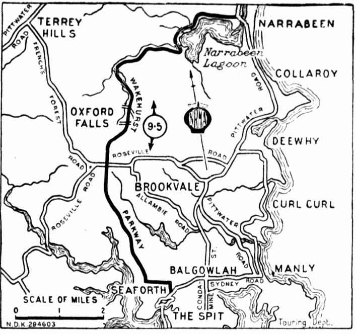
From its junction with Main Road No . 164 (Sydney-road ) in Seaforth, the new road follows fairly closely the alignment of French's Forest road to Mai n Road No . 328 (Rodborough-road), and then proceeds past Oxfor d Falls in a general northerly directioa through the Middle Creek area to the western and northern shores of Narrabeen Lake, which it follows to its junction with Main Road No . 164 (Pittwater-road) at Narrabeen. Throughout its length the road is flanked by natural bushland amid attractive scenery, and it is for the purpose of preserving these that a wide road reservation is being acquired.
T h e length of the road is 9.8 miles, of which 7.75 miles are new construction in virgin country. For the remainder of the total length ( 2 miles at the southern end and 0.05 miles at the northern end ) the existing pavement was resurfaced and incorporated in the new work.
from DEPARTMENT OF MAIN ROADS. - TWENTY-FIRST ANNUAL REPORT FOR Year ended 30th June, 1946.
Interestingly Governor Wakehurst's name is that which appears in this gazettal which commenced the works and put an end to Mr. Stone's enterprise:
TRANSPORT (DIVISION OF FUNCTIONS) ACT, 1932-1940.
MAIN ROADS AGT, 1924-1939.
PROCLAMATION.
(L.S.)
WAKEHURST, Governor.
I, the Right Honourable John de Vere, Baron Wakehurst, Governor of the State of New South Wales, in the Commonwealth of Australia, with the advice of the Executive Council and by virtue of the provisions of the Transport (Division of Functions) Act, 1938-1940, and in pursuance of the provisions of the Main Roads Act, 1924-1939, do by this my Proclamation declare that so much of the land hereunder described as is Crown Land is hereby appropriated, and so much thereof as is private property is hereby resumed under the provisions of the Public Works Act, 1912, for the purposes of the Main Roads Act, 1924-1930, and that the land hereunder described is hereby vested in the Commissioner for Main Roads, and I hereby further declare the land hereunder described to be a public road, and, in accordance with a recommendation of the Commissioner for Main Roads, the §aid land is hereby placed under the control of the Council of the Shire of Warringah.
Signed and sealed at Sydney, this twenty-fourth day of July, 1941.
By His Excellency's Command,
M. O'SULLIVAN. GOD SAVE THE KING!
Description of The Land Referred to.
All that piece or parcel of land situate in the Shire of Warringah, parishes of Manly Cove and Narrabeen, county of Cumberland and State of New South Wales, being part of the land in Certificate of Title, register volume 3,056, folio 68 and part of E. 7.49.9 for public recreation notified 6th October, 1888: Commencing at a point on a southern boundary of the land in the Certificate of Title aforesaid bearing 99 degrees 26 minutes 25 seconds and distant 474 feet 71 inches from the south-western corner of that land and bounded thence on the west, north-west, north-east, again on the northwest, south-west and again on the north-west by marked lines bearing consecutively 358 degrees 20 minutes 15 seconds 180 feet 5| inches, 1 degree 38 minutes 45 seconds 112 feet 6J inches, 7 degrees 56 minutes 30 seconds 100 feet, 13 degrees 51 minutes 10 seconds 104) feet, 19 degrees 45 minutes 45 seconds 100 feet, 25 degrees 40 minutes 20 seconds 100 feet, 31 degrees 34 minutes 55 seconds 100 feet, 37 degrees 29 minutes 30 seconds 100 feet, 43 degrees 24 minutes 109 feet, 49 degrees 18 minutes 40 seconds 100 feet, 55 degrees 13 minutes 15 seconds 100 feet, 61 degrees 7 minutes 50 seconds 100 feet, 64 degrees 5 minutes 5 seconds 386 feet 3| inches, 154 degrees 5 minutes 5 seconds 55 feet, 64 degrees 5 minutes 5 seconds 450 feet, 334 degrees 5 minutes 5 seconds 55 feet and 64 degrees 5 minutes 5 seconds 690 feet to the waters of Deep Creek; thence, generally on the south-east and north-east by the waters of Deep Greek and Narrabeen Lagoon to a point bearing 165 degrees 29 minutes 303 feet 0 inches from the south-eastern corner of the land in the Certificate of Title aforesaid; thence again on the south-east by marked lines bearing 203 degrees 4 minutes 183 feet, 212 degrees 57 minutes 30 seconds 147 feet 5£ inches and 225 degrees 38 minutes 30 seconds 33 feet to the waters of Middle Creek; thence generally on the south-west by the waters of that Creek to a point bearing 197 degrees 32 minutes 515 feet 10 minutes from the point of commencement; thence on the northwest and west by marked lines bearing consecutively 45 degrees 38 minutes 30 seconds 50 feet, 32 degrees 57 minutes 30 seconds 100 feet, 23 degrees 4 minutes 100 feet, 13 degrees 10 minutes 30 seconds 100 feet, 3 degrees 17 minutes 300 feet and 358 degrees 20 minutes 15 seconds 83 feet 10f inches to the point of commencement,—having an area of 16 acres 2 roods 5 perches or thereabouts and said as to part to be in the possession of E. G. Stone. (D.M.R. No. 479-1,335) (3581) TRANSPORT (DIVISION OF FUNCTIONS) ACT, 1932-1940. (1941, August 1). Government Gazette of the State of New South Wales (Sydney, NSW : 1901 - 2001), p. 2779. Retrieved from http://nla.gov.au/nla.news-article225122797
Dedication stone still present - A J Guesdon photo -
Lord Wakehurst and Lady Wakehurst on arrival in Sydney as Governor of New South Wales in 1937. Item Photo courtesy State Library of NSW
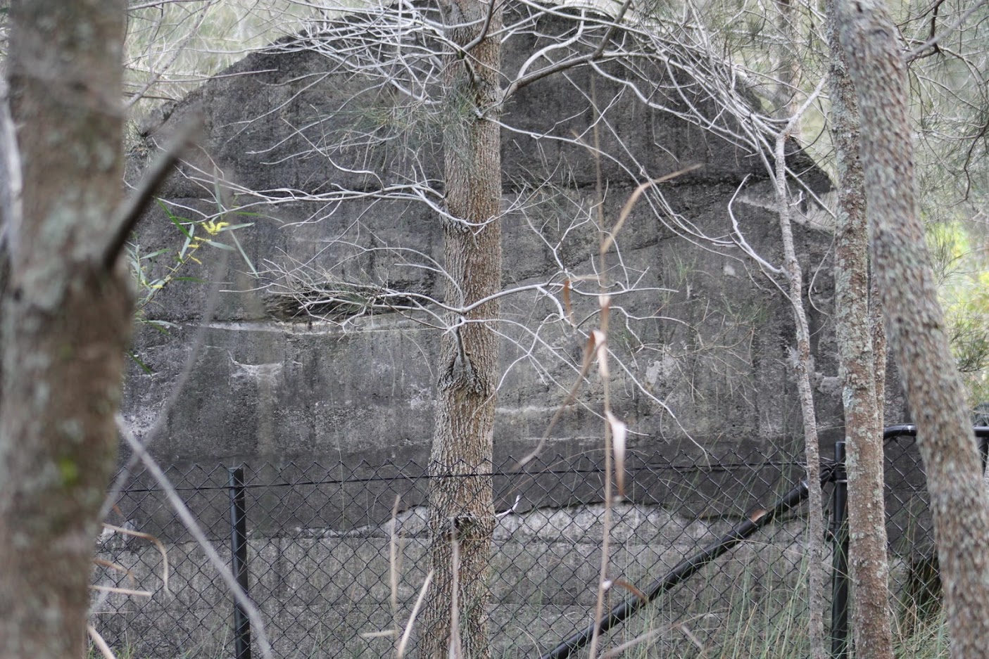
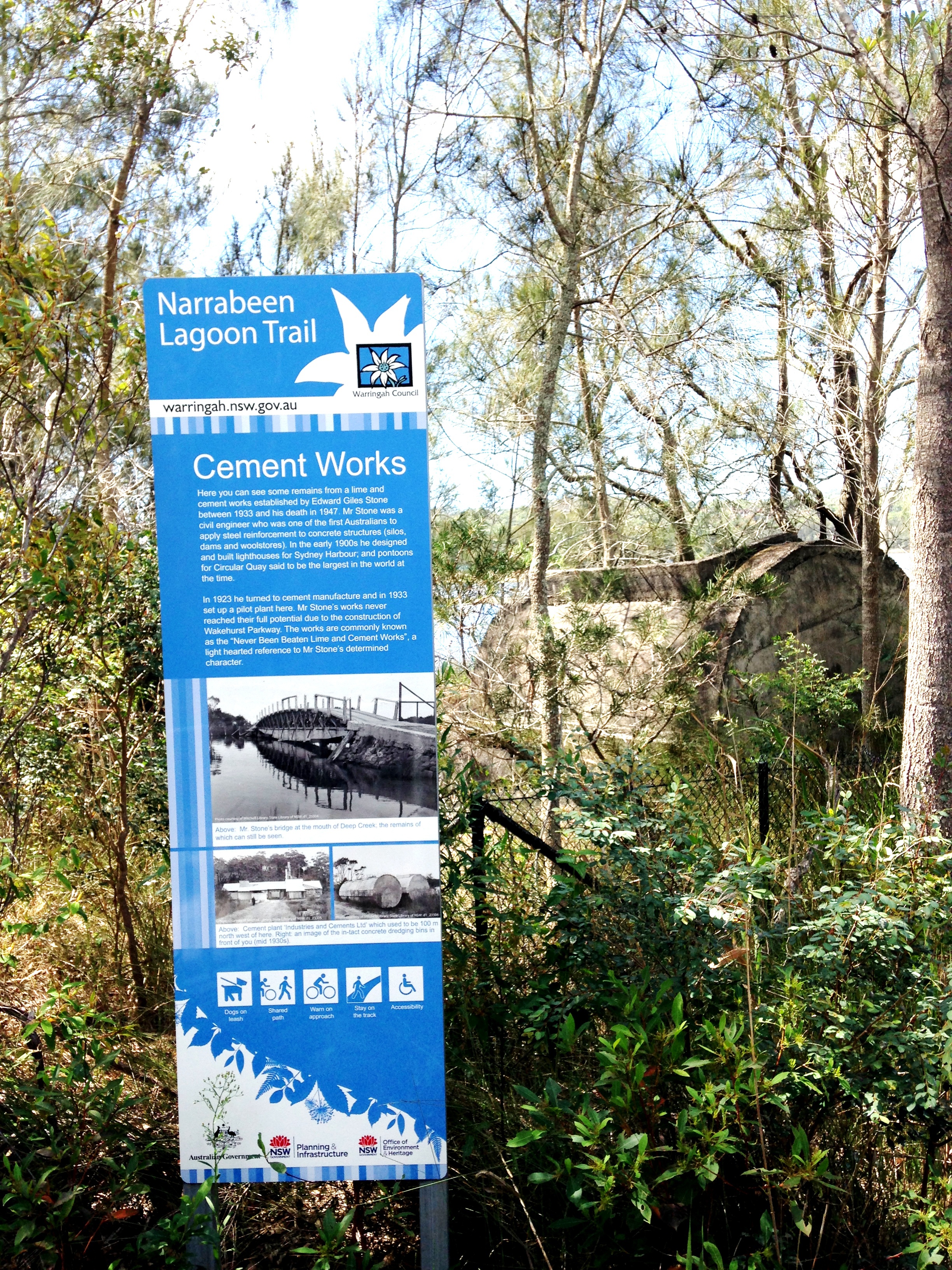
Remnant of Stone's cement works on Narrabeen Lagoon - photo by A J Guesdon, 2014
Stone's cement works information board - photo by Joe Mills, 2020
The work of improving the Wakehurst Parkway continued:
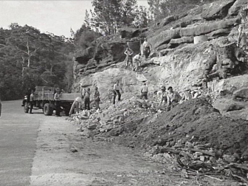
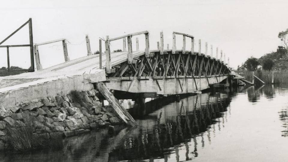
Men working on widening the Wakehurst Parkway near Deep Creek in 1949
Then, as now, the incumbents struggled to get improvements done for a variety of reasons, all leading back to those in 1929, on the verge of the economic Depression of the 1930's, of financial viability and fiscal responsibility - especially during post WW2 shortages. Some of those passing through weren't helping out either:
Road thefts by motorists.
Motorists are stealing roadmaking materials from Wakehurst Parkway, French's Forest.
Transport Minister Sheahan said this last night. Police assistance had been sought and future offenders would be dealt with as criminals stealing from private property, he said. "It is extraordinary to find a mentality in a so-called respectable section of the community that sees no evil in taking valuable property owned by the department," Mr. Sheahan added. "The offence is more serious, in the case of motorists, because the materials are needed to improve the roadway and give better visibility at corners." Road thefts by motorists (
1951, August 19).
The Sun (Sydney, NSW : 1910 - 1954), p. 44. Retrieved from
http://nla.gov.au/nla.news-article230232351
Ancient Carvings
Sir,-I am told that motorists are destroying ancient aboriginal carvings by driving over them on Wakehurst Park Road in French's Forest.
These carvings, I believe, come under the care of the Crown Lands Department, and this being so it is to be hoped that the Minister will see that these strange and interesting works are preserved.
MICHAEL SAWTELL.
[The opinions expressed in this Journal are not necessarily those of the Master Builders' Association, unless otherwise stated.} WARRINGAH AS A SATELLITE TOWN
The Warringah and Manly district has been in the news of late with the prospect of an upheaval in the local transport services. Without taking sides in the controversy between the State transport authorities and the local residents it is still possible to review the potentialities of this delactable land and engage in a little daydreaming concerning its future. Within the space of little more than one generation there has been considerable residential expansion between Manly and Narrabeen while others have ventured further north establishing popular settlements fronting the ocean beaches all the way to Palm Beach. The bus services from the city have been largely instrumental in converting the area from a series of week-end resorts to established outer suburban areas. Always, however, there has been the promise of a future electric railway to increase public confidence in land acquisition and building construction in the district., Provision is made for such a railway in the four tracks on the Harbour Bridge. While, however, years were wasted in coming to a decision as to the route, residential building has been going on apace and adding greatly to the prospective resumption costs, and in a natural terrain that must inevitably mean high construction costs. First the railway was to go through Mosman to Manly. Then a shorter route through Northbridge was favoured. In either case there was the prospect of a bridge costing a million or two to span Middle Harbour.
On this point is might be noted that recent bridge contracts run to four or five times the pre-war unit rates. An independent and supplementary scheme was also propounded years ago by the late Dr. J. J. C. Bradfield. This was to construct an electric railway branching north of Pymble and passing round the head of Middle Harbour through St. Ives to open up the high ground of French's Forest for suburban development. It was pointed out at the time that the sale of Crown lands could pay for the railway construction. Meantime, apart from the construction of the Wakehurst Parkway, which still lacks the building of the high level bridge over Middle Harbour at Sugarloaf Point, the State authorities have done little for Warringah, leaving the district to the local shire council and to private enterprise. It seems that this condition of affairs is likely to continue as the Cumberland County Council has sidestepped the problem by placing much of the area in its Green Belt. Warringah residents and property-owners must look to themselves for further developments. There would be better prospects of securing a railway connection after the population has considerably expanded to guarantee sufficient density of traffic. It is all bound up with the political history of this State which realists study and carefully observe.
Warringah, nevertheless, has such potentialities in itself that it could be a location for a satellite town, that is to say a largely self-contained population block of at least 20,000 residents, or even several blocks of 10,000 and upwards. For this purpose the locality would require extensive retail business development, schools and high schools and local sources of employment, such as light industries which could easily be tucked away in the numerous gullies intersecting the higher ground. In addition to transport problems another factor has influenced the State authorities in declining to encourage development in Warringah. That is the difficulty in providing water sup' plies with, at a later date, sewerage services. The same would apply, though in lesser degree to the other public utilities. As regards water supply the local Manly waterworks served the whole district for a number of years until supplemented from the metropolitan supply system by pipe mains crossing Middle Harbour at the Spit and later by' larger mains from Pymble. Eventually these led to the closing of the old Manly waterworks. If further extensions from the metropolitan system are considered to be out of the question for the present then a reversion could be made to local supplies. Other dams could be built or well sources adjacent to the lagoons explored. A filtration plant was employed in the case of the Manly works -and such plants would ensure pure water from other prospective sources. Manly also has scope for residential expansion in the quarantine station area. There have been suggestions for removing this area to a site in Broken Bay or elsewhere. About twenty years ago the ocean frontage with its high cliffs was dedicated as a public park. It is worth looking into the prospective value of the quarantine area if subdivided and sold for residential purposes. The return could conceivably prove sufficient for transfer of the quarantine station. Editorial (
1952, January 23).
Construction Construction (Sydney, NSW : 1938 - 1954), p. 1. Retrieved from
http://nla.gov.au/nla.news-article223547021
A parkway is a broad, landscaped highway thoroughfare. The term is particularly used for a roadway in a park or connecting to a park from which trucks and other heavy vehicles are excluded. Many parkways originally intended for scenic, recreational driving have evolved into major urban and commuter routes.
However, the Wakehurst Parkway between Narrabeen, The Spit, Frenchs Forest and beyond has stayed true to its original moniker with successive governments and local councils adopting a hands off approach so this green corner and corridor remains just that.
Some photos from the year of completion for comparison of the way to Narrabeen which show some sections have been kept a park around a parkway:
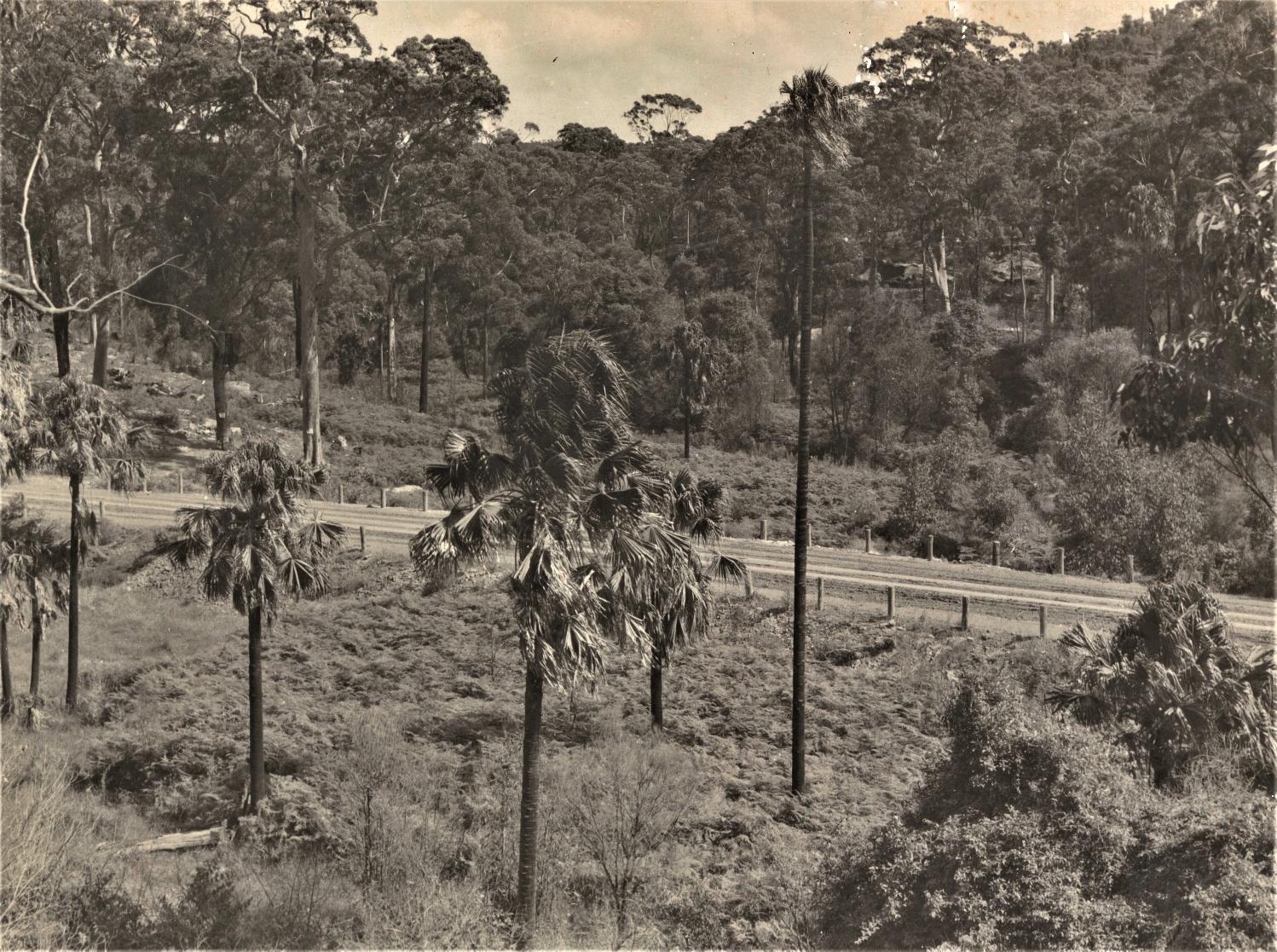
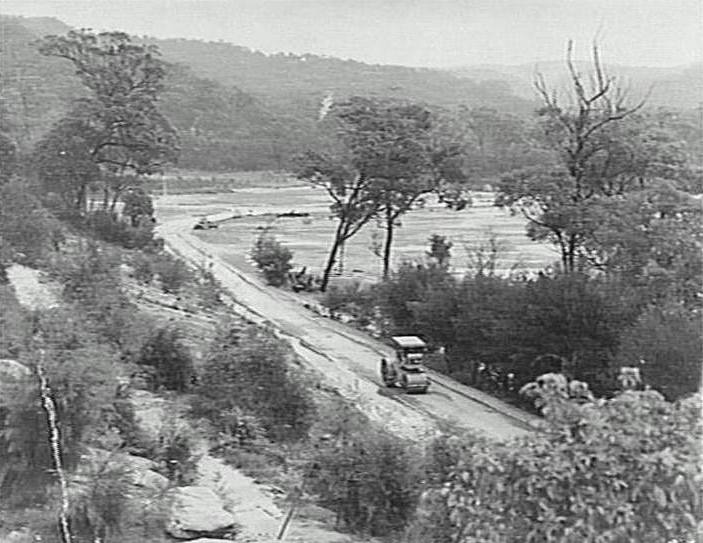
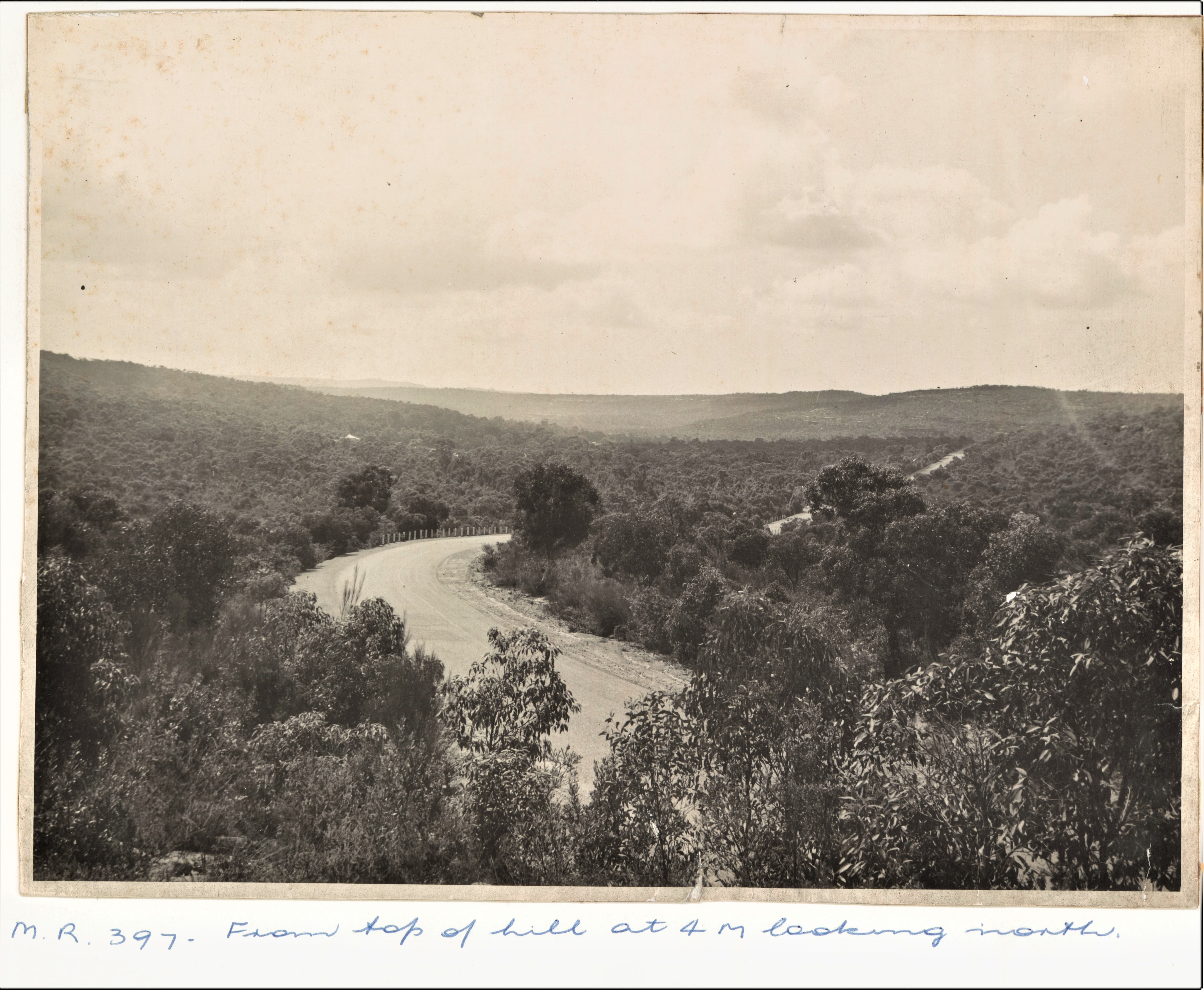
Main Road 397 - From top of hill at 4 miles looking north. [Wakehurst Parkway] Sept 1946, photo courtesy NSW State Archives & Records.
Main Road 397 - from 6 miles 3200 feet looking north. [Wakehurst Parkway] Sept. 1946, photo courtesy NSW State Archives & Records.
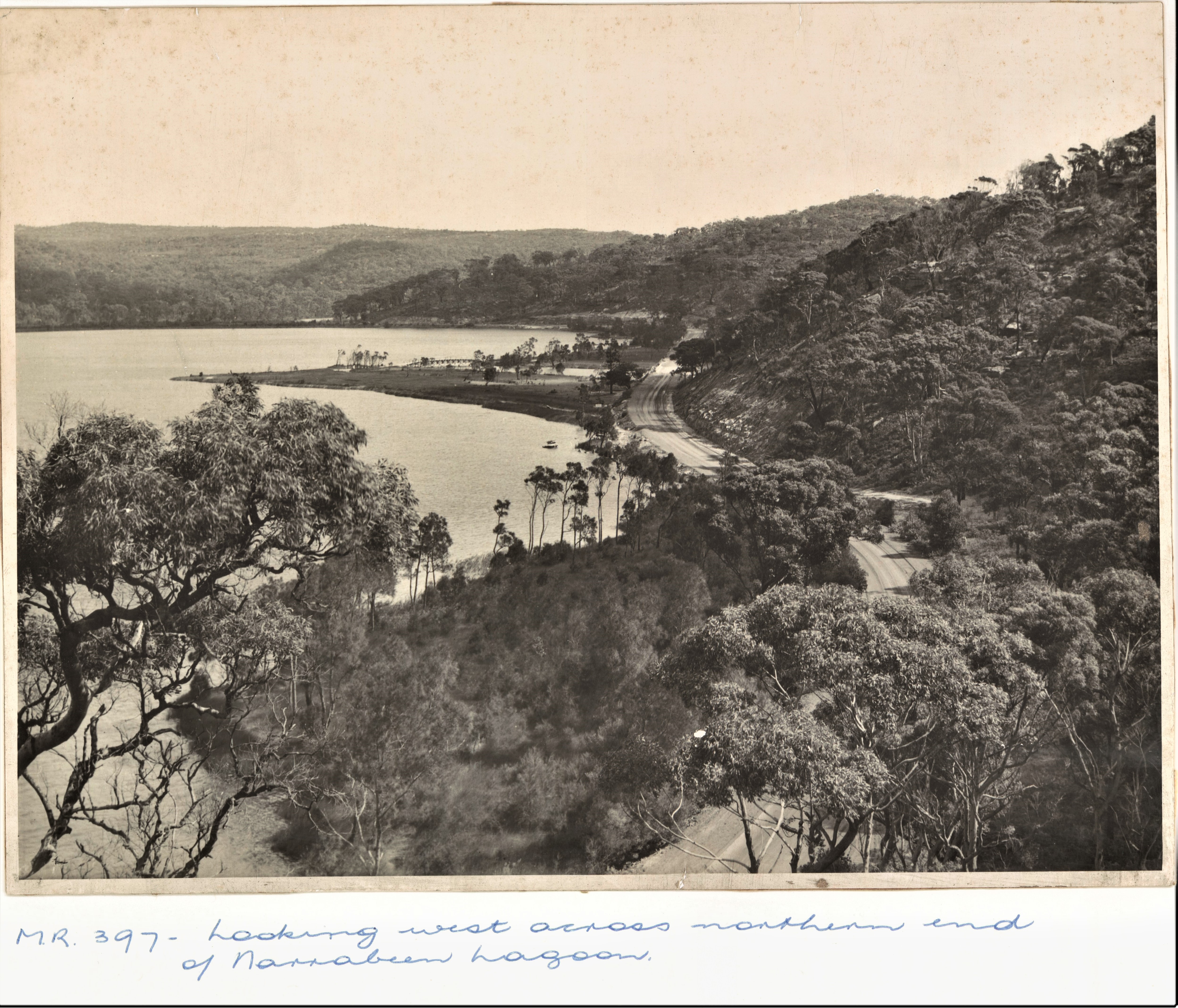
Main Road 397 - Looking west across northern end of Narrabeen Lagoon. [Wakehurst Parkway], photo courtesy NSW State Archives & Records.