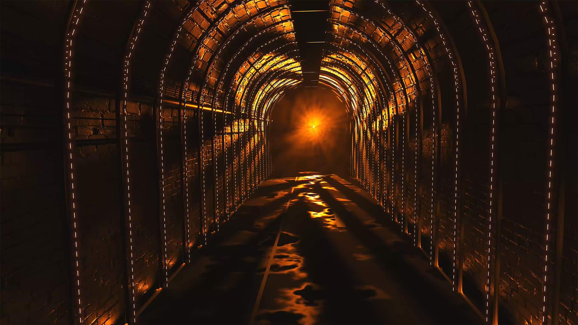
Vivid Sydney, Sony Music, Mandylights and Culture Creative announced that Australia’s largest festival has added a first-ever activation of the Wynyard railway tunnels to its program with the world premiere of Dark Spectrum at Vivid Sydney 2023.
Three years in the making and tipped as an underground spectacular of what lies beneath, Dark Spectrum fuses a dynamic musical soundtrack with the latest in laser, robotics, lighting and visual technology to transform the disused Wynyard Station train tunnels in a truly one-of-a-kind experience in a venue that has never been open to the public.
Creating an immersive multi-media environment, Dark Spectrum delivers a heightened visual and audio experience for Vivid Sydney attendees set to penetrate the deep underground of Wynyard’s tunnels and take its audience into a new time and space. Secret passageways have been lit, pulses of electronic dance music ring out across eight-rooms, with each space representing a different human experience and associated colour. Guests move through rooms themed to separation, constriction, pressure, the unseen, reflection, the unfamiliar, connection and end with a revelation.
Highlights from Dark Spectrum include ‘Constriction’, 150 LED “pipes” hung from the roof to form an interactive landscape of animated pixels that can be touched; ‘Pressure’, a spectacular array of 50 archways covered in lights and mirrors that create the visual illusion of a never-ending tunnel; and ‘Interaction’, an Avatar-esque environment featuring hundreds of hanging strings of light interspersed with illuminated alien plants that respond to movement.
Presented in partnership with Vivid Sydney, Sony Music, Mandylights and Culture Creative, Dark Spectrum will premiere at Vivid Sydney on 26 May, running until 16 July before touring the world.
Vivid Sydney Dark Spectrum installation. Photo supplied
Dark Spectrum is a ticketed experience with entry via Wynyard Park Rooftop between York and Carrington Streets, Sydney. Entry will be timed from 12:00pm to 9.15pm. Ticket prices vary depending on visit date/time; general admission from $35, children from $24, families from $98.
“We’re thrilled to announce this world-first experience for Vivid Sydney 2023. Dark Spectrum is a perfect fit for this year’s festival theme, exploring the intersection between human emotions, our natural environment and the urban landscape and relics of Sydney’s industrial past.
“Diving beneath the surface of what is now one of the city’s busiest railway lines, Dark Spectrum is a truly mesmerising and engaging experience for visitors to explore Sydney in a whole new way. I am excited we get to shine a light on unknown spaces across the city,” says Gill Minervini, Vivid Sydney Festival Director.
This year, Vivid Sydney is delivering the biggest and most culturally relevant program in its event history. The festival runs until Saturday 17 June. The spectacular Light Walk will host the works of 100+ light collaborators and 26 international light artists from 13 countries, with street installations, re-shaping old sights, surprising projection sites and large-scale immersive experiences that will paint the urban landscape.
Vivid Sydney is being staged across Sydney’s city centre, at locations including Circular Quay, the Sydney Opera House, The Rocks, Walsh Bay, Barangaroo, King Street Wharf, Darling Harbour, Darling Quarter, Darling Square, The Goods Line, Central Station, the Royal Botanic Garden Sydney, Carriageworks, Taronga Zoo and more. Get tickets at: www.vividsydney.com
The event happening in the old Wynyard tunnels brings up the conversations of a century before 2023, when the building of tunnels for trains included one for Narrabeen, along with a harbor bridge for Sydney. This talk arose decades after the 1889 proposals for a train to Narrabeen alongside the current Mona Vale Road ands continued;
THE PROPOSED ST. LEONARDS TRAMWAY.
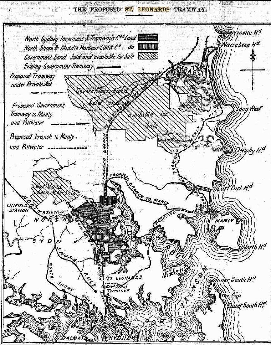
Though within easy distance of Sydney, very little is known of the magnificent charnpaign country lying contiguous to the many bays which are to be found in Middle Harbor, certainly the most beautiful portion of our beautiful harbor." The many who take the trip round the harbor, going up its glorious waters up to Green Cape, seen on either side steep, rock -guarded uplands, with a rich mass of verdure clothing them with perennial green ; but few have explored these uplands from the land side, or have any conception not only of the goodness of the land but of the magnificence of the views to be obtained from almost every point. Here, extending north of Si. Leonards, is a grand sanatorium— a large extent of country in its native state, consisting of undulating land covered with heather and thick undergrowth, running eastward towards the waters of Middle Harbor. Some time since this attractive area, which hitherto had lain idle, being cut into allotments mainly owned by one man, attracted the attention of two gentlemen who saw that bore was an opportunity of bringing these magnificent sites for suburban residences within easy access of Sydney, opening out country with the finest uplands, breezy and health-encouraging, running on towards the waters of Middle Harbor, and at the same time forming a straight route on to Pittwater and Narrabeen, two place which in the near future must become of increased importance, not only us holiday resorts but also as settled centres of industry. The idea was that a tramway line carried from the present terminus of the North Shore cable tramline at the corner of St. Leonards Park, straight along Miller-street, on through the municipality of North Willoughby to a point near the head waters of Middle Harbor would not only be a good speculation but would also be the means of bringing into existence a new' suburb, which in point of picturesque beauty of scene would outrival many of the beautiful outskirts of the city. A thousand acres of ground shown' in the annexed plan marked with horizontal and perpendicular lines were acquired by purchase by Mr. Andrew Armstrong and Mr. James Alexander Brown, each owning 600a., and after much consultation and many and varied calculations it was decided to get permission, if possible, from Parliament to construct a tramway to the extremity of the property so acquired. After some trouble the matter was brought before Parliament, and on July 18, 1887, an Act was assented to authorising Messrs. Armstrong and J. A. Brown to construct and maintain a tramway along the proposed route.
The description of the tramway in the Act is from the terminal point of construction of the St. Leonards cable tramway, along Miller-street, Palmer-street and Bellevue-street, in the town and municipality of St. Leonards, and through certain private land, across French's-road, Mowbray-road, M'Lellan-street, -Victoria-avenue and along Murano-road, in the municipality of North Willoughby. It was specified in the Act that the tramline should not occupy in any part of a road or street a greater space in breadth than 22ft. including the support and foundations ; that it should be constructed and brought into use within three years from the passing of the Act and constructed In a workmanlike manner that nothing should impair the lawful authority of the municipalities of St. Leonards and North Willoughby or of any other corporation to construct, maintain and preserve gasworks, water works, sewerage works and other works lawfully constructed under ground ; that the gauge of the tramway should be 4ft. 8 ½ in. that it should be laid with rails subject to the approval of the Commissioner for Railways; "that the promoter should maintain in perfect order the tramway and the pavement of the streets between the rails and for the space of 1ft. Oin. on each side of the rails, and should erect all necessary causeways ; that they should emptor electricity, locomotive engines, stationary engines with cable connection, horses, or other moving power ; that they should be responsible for all injuries caused through negligence or improper construction ; that regulations should be framed, but none or' them should authorise the closing of the tramway between sunrise and sunset, except at any time when In consequence of any of the works being out of repair it should be necessary to close the line or any part of it ; and finally, that the Government should have power at any time to purchase the line at its then assessed value.
After this the land, which had been purchased by Messrs. Armstrong and Brown, who were the real fathers of the scheme, attracted the attention of a number of capitalists, and two companies were formed, who in December, 1887, and January, 1888, acquired the whole of the land. The first of these was styled the North Sydney Investment and Tramway Company, with a nominal capital of a million sterling, and the land owned by them is shown on the map marked with horizontal lines. The second company the North Shore and Middle Harbor Land Company, with a nominal capital of £1500,000, has its property distinguished by perpendicular lines, and as will be seen, this company own two pieces of land away from the proposed tramline, the one to the left an area known as the Royal Park Estate, and the other an allotment 270a, in extent on the opposite side of Middle Harbor, near where there is a further proposal to erect abridge for a road or train extending from the proposed line. This area of ground which has been bought with a view to further, development has a water frontage on the main waters of Middle Harbor, commencing at a point situated just above a small cove, where the steamers plying usually turn and close to an exquisite spot — a crag bound little peninsular extending to the water, covered with a beautifully green carpet of turf surrounded by rich and variegated, woodland foliage. This spot was a favorite resort of Sir Hercules Robinson when Governor of New South Vales, and he and his family and friends were wont to come here picnicking. The whole of this property, owned by two companies, is well adapted for residential purposes. The total length of the proposed line is about three miles and a half, the distance from the present cable tram terminus to the bridge at Long Bay being one mile, and it is stated that will present but few engineering difficulties.
THE LAND PASSED THROUGH.
Hitherto the whole of the large area of country situated within the boundaries of the borough of North Willoughby, and extending back to the parish of Gordon, has been to a great extent cut oft' from communication with Sydney in consequence of the rugged gorge formed by the waters of Long Bay, the southernmost arm of Middle Harbor, the waters of .which extend a long distance westward, terminating in what in summertime is a Huge canon with steep sides, mid at whose bottom lie huge boulder, through which the course of g . creek 'is discernible, its existence being marked only by. here and there a limpid pool of water and its sides, rough, uneven land, which might be utilised without trouble, and on the slopes of which arc dotted here and there a number of residences of all kind, some of them of the most primitive type. The design of the proposed tramline, which is to be at once proceeded with, is to bridge this chasm and to open out in the first instance the areas running on the one side out through the territories included in the borough of North Willoughby comprising the lauds through which the railway to Crow's Nest runs, and on to the unimproved and at present, owing to the unwillingness of the proprietor to sol unimprovable, estate owned by Mr. David Berry, the whole of the original grant known as .Wolstoncrofte, and on the other the areas running eastward to though shores of Middle Harbor and its numerous offshoots. This latter is comprised in four distinct ridges ; the first and the largest of the four in point of area, bounded on the south by Long Bay and on the north by Mowbray Bray : the second between Sailor's Bay and Sugar Loaf Bar ; the third a beautifully-situated promontory on either side of what is known as Sugar Loaf Bay ; and the fourth washed on either side by the main waters of Middle Harbor up to beyond its navigable waters. This is in effect the design, of the first portion of the scheme shown on the plan, but its extension is contemplated on to Pittwater with a detour to the west to Manly.
Taking the tramline as proposed, the first portion will run from the present terminus of the cable tramway, (by the Government) at the south-western corner of St. Leonards Park along Miller-street for a -distance of a little over a mile to the waters of Long Bay, and will bring into direct and near communication with Sydney the whole of the northern portion of the borough of .St. Leonards, as on either side of the. line there is a large population, with spacious well-formed streets. The whole of the land to the left of the line is portioned off into streets up to the boundaries of the Berry Estate, a small portion of which has been alienated. And on this stand numerous residences and places of business, besides several public buildings, including the pretty cottage hospital—a credit to the borough, which was formally opened by Sir Henry Parkes less than a year ago. To the right of the line is the St. Leonards Park — a well laid out public reserve —which is yearly being Improved; while beyond, a little, further to the westward, below Ernest-street, is situated Cammeray Park, a triangular piece of ground through which passes a road leading to Cammeray Point, whilst in a once sequestered nook, which has been of late invaded by a tramline leading to Borne quarries at the extremity of a little harbor is situated Folly Point, approached by a road formed by the St. Leonards corporation, a favorite boating and fishing resort, but which is not. used as it might be owing to the difficulty of access from Milson's Point. The gorge at Long Bay is to be crossed by a handsome suspension bridge, and after crossing this the line enters upon the territory of the borough of North Willoughby.
At present the only means by which this borough can be reached from Milson's Point direct is by the Sydney-road, a well-formed thoroughfare, whilst the bay as it is still called, though it really is a creek, dry in summer but a roaring torrent after heavy or even moderate rains, has been spanned through the energy of the North Willoughby Council by a massive stone bridge, which cost somewhere about £5000. Near here, perched on the heights, are the residences of Mr. Thomas Datton, M.P., and Mr. Douds, M.L.C. Passing over the bridge the road ascends, and though the land is pleasant and the scenery delightful there is not much settlement until what is known as the Central Township is reached, a beautifully laid out little village, where there are numerous pretty residences and a large tannery, the most extensive to be found around Sydney, owned by the Messrs. Forsyth, who have taste-full villa residences in the vicinity. The whole of the rest of the country to the westward of the land, including Mowbray Park, the township of North Sydney, Alleyne Park, the Artarmon Estate and numerous other allotments — some merely fenced in, others lying waste, and others again built and settled upon— is a rich country, where gradually people are finding their way, and which only wants an impetus such as a tramline should impart to make it one of the gardens of New South Wales. As an instance of progress, it may be stated that out in this now distant and but little-known suburb, at a spot whore there is but a straggling population, Mr. Museton is meeting a line hall to be called the Centennial.
But after all in connection with the tramway, it is the land situated to the eastward, with some seven miles of frontage to Middle Harbor and extending from Long Bay to the topmost arm of the harbor, which will give it Its chiefest charm and value. No finer views are to he obtained near Sydney, and the combination of water and wood and tree and fern, upland and valley and clear heathland and rocky defiles, clothed with all the rich flora and ferns of New South Wales, are all beautiful. The whole of this country is owned by the two companies who hare taken in hand the task of constructing and carrying on the tramway, with the exception of a few stray allotments which are shown in our plan, and several valuable reserves which have been retained, but never up to the present time used by the Government. The first ridge through the extremity, of of which the tramway will pass is bounded on the south by Long Bay, with a curious inlet known as Saltpan Creek, which many years ago was looked upon us a natural dock, and which it was intended should be used for Government purposes. This is included in a large reserve designed partly for a site for harbor defences and partly for a training school for boys from the ship Vernon, but up to the present it remains wild and unimproved. The whole of the land on this peninsula has been partially cleared and a fine roadway formed, whilst from a lofty dome-shaped hill which rises abruptly from the surrounding plateau an attractive view of the harbor and its tributaries is to be had. Below, abutting sharply on the water is Figtree Point, a well-known resort by persons voyaging into these waters, and at the northernmost extremity of the promontory a piece of laud known ns Albert Town, with a park reserve adjoining, to which the rood, which has been formed partly by the company and partly by the borough council, descends. Opposite is the curious point known as Quaker's Hat and a rich flat, which some time or another must become valuable. All the land on this area is well adapted for residential sites. The ridge beyond this is intersected by Mowbray-road, and the character of the land is similar, though in parts more rugged, while the scenery as we advance northward assumes a bolder and more mountainous character, softened always by the glorious stretch of water which spreads itself in all directions, terminated by lovely bays and rich campaign areas. The most northerly of the ridges, and by far the most beautiful, is at present approached by the Teralba-road leading from Alleyne Park and descending to the bond of Sugarloaf Bay, where there is a considerable settlement. A creek runs in to the bead of the buy, and along its banks are two tanneries and a number of pretty residences, all surrounded by gardens and orchards; in fact, everywhere in this fertile region fruit trees seem to flourish to an astonishing extent, and wherever the hand of man has been at work luxurious gardens are to be found. On the heights to the southward of Sugarloaf Bay, near Mount Wilson, there is a large Chinese garden of some 21 ha., owned by a man who in years past was a celebrity amongst his countrymen, one Chenateak, and here a large vegetable trade is done. At the back of the garden there is a joss house which is used by the numerous Chinese gardeners, who have made for themselves a home in various likely spots throughout the borough of North Willoughby— In fact, wherever water was to be found.
The proposed tramway terminates on a crested hill, known as Echo Farm, after crossing a rock-embrasured creek which just below the tramline passes through a series of rocky' basin, and then tumbles over a precipice, forming n waterfall some 70ft. or 80ft., the sides of this narrow gorge, only about 10ft. in width, being covered with ferns and every species of flora and shrub. As opening out this magnificent country and thus bringing within easy reach a land but little known either to the tourist or the resident of Sydney the tramline proposed, apart from any profit it must bring to the companies who have obtained permission to construct It, must be regarded as a public benefit." Its extension, as contemplated, on to Manly and further afield to Narrabeen and Pittwater, in lieu of the line proposed through St. Leonards and across the Spit by means of a bridge, is a matter only of time. THE PROPOSED ST. LEONARDS TRAMWAY. (1889, January 19). The Daily Telegraph (Sydney, NSW : 1883 - 1930), p. 9. Retrieved from http://nla.gov.au/nla.news-article235866189
The bridge referred to above was originally called the North Sydney Bridge. The depression of 1892 saw both companies go into liquidation and at that point the name Northbridge began to appear. This downturn was caused by a number of factors including a severe drought, the sinking of wool, wheat and metal prices, and most of all, the withdrawal of British investment in NSW on a major scale.
The plan for a train to Pittwater persists:
TURNED DOWN. A SUGGESTED RAILWAY. GORDON TO PITTWATER.
In ten years time you might have a chance: to-day you have none. This in effect was the reply made yesterday by the Minister for Works to a deputation which waited upon him with a request that he would favourably entertain the building of a railway from the North Shore line in the neighbourhood of Gordon or Pymble across to Pittwater with Broken Bay as the final objective. The deputation lacked nothing in numbers. There was a strong representation of the Kuringai and Warringah Shire Councils, of the Kuringai Ratepayers' Association, and of the Pittwater Progress Association It was introduced by Mr. Wade who with Dr Arthur emphasised the advantages to be derived from the construction of the proposed line. Dr Arthur enlarged on the advantages of throwing open for settlement country that from the standpoint of hygiene lacked nothing. It would be an ideal district he said for testing the Government scheme for erecting workmen’s homes. The land lay from 600 to 700 feet above sea level the surroundings were most picturesque and it lent itself well to drainage and sanitation. Since Sydney was increasing at such an enormous rate people would be driven more and more Into the Suburbs and he thought It would be a pity to compel them to seek homes along the low lying parts served by the Western line or along the shores of Botany Bay when such elevated and beautiful country as that lying between the North Shore line, and the ocean could be made accessible.
The Rev. Paul Clipsham president of the Kuringai Shire Council said the country lying between Gordon-Pymble on the one side and Narrabeen-Mona Vale on the other rivaled In its beauty anything to be seen on the Blue Mountains. He had not the slightest doubt that if the line were constructed it would develop an enormous passenger traffic. A line 17 miles long would open up the district well and seeing that there are no engineering difficulties to be overcome, he did not think It would be an expensive line to build. Apart from that it would greatly enhance the use of Crown lands through which the railway would pass. In all probability it would pay almost from the start. It would run through St Ives one of the most thriving fruit growing districts in the state. It would carry heavy consignments of fruit to Sydney and doubtless when communication with Broken Bay was opened up much of the fish supply of Sydney would be carried by It.
Messrs Ralston (president of the Warringah Shire Council) Griffiths, T. W. Taylor, Jones (secretary Pittwater Association) and R D Brown also addressed the Minister In Support of the railway project.
It was pointed out that Broken Bay would play an important part in any scheme of defence and that under these circumstances the Defence Department of the Commonwealth might be prepared to contribute to the cost of the maintenance of the line.
The Minister for Works said one of the stock arguments used by advocates of railway projects was the bearing the line would have upon defence. His business was to build lines not for defence purposes but for the development of the country. If however, there was anything in the suggestion that the Defence Department would pay part of the cost of a line to Broken Bay he would of course go carefully into the matter. He did not need to be told anything about the beauties of the country through which the proposed line would pass. He knew the country and it was the most beautiful country he had ever seen. It was to Australia what the Riviera was to Southern Europe. But he could not give the deputation a very encouraging reply. In time the railway would he made but he could not see his way to regard it as one of pressing necessity. Apart from that it would be enormously costly. The North Shore line cost £55 300 per mile and on that basis it would cost over a million to build the 20 miles to Broken Bay or if the line stopped at Mona Vale the cost would run to three quarters of a million. That was an enormous sum to spend to open up even so beautiful a district as the one in question. It would be a very fine thing for the landowners of the district whose property would be enormously increased in value. The State would get little out of it seeing that barely 1 ½ miles of the line would pass through Crown land. If the railway were justified on other grounds he would not object to making the fortunes of the landowners of the district.
But it was not Justified seeing the larger areas of unoccupied land to which the North Shore line gave access. Within 1 ½ miles of Wahroonga station alone there were hundreds of acres of primeval bush and the same thing applied to other stations along the line. The land was being held by owners, waiting for fancy prices. That land must be settled before the line to Pittwater could be considered. It was the policy of the government to spend what money it could get in building railway to open up wheat and agricultural country.
That was obviously more urgent work than building a railway into residential country which already had a railway on one side and would have an electrical tramway on though other side. It was proposed to have the electric tram service extended to Mona Vale. The line would be built off the road and In order to secure a speedy service the stopping place would be at Intervals of quarter or half mile. For quite a number of years that is all the residents could expect to get. The railway would come some day. Perhaps if the deputation waited upon the Minister 10 years from now they would probably get a more encouraging answer than he was able to give. TURNED DOWN. (1911, November 21).The Sydney Morning Herald (NSW : 1842 - 1954), p. 7. Retrieved from http://nla.gov.au/nla.news-article15290696
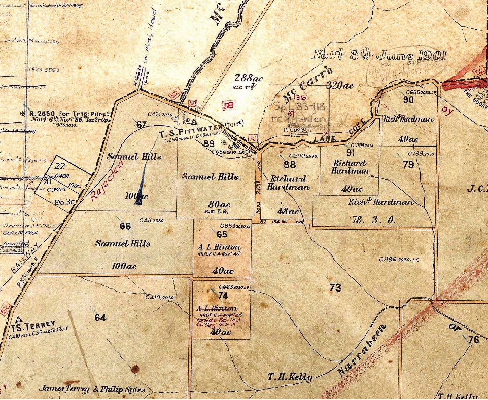
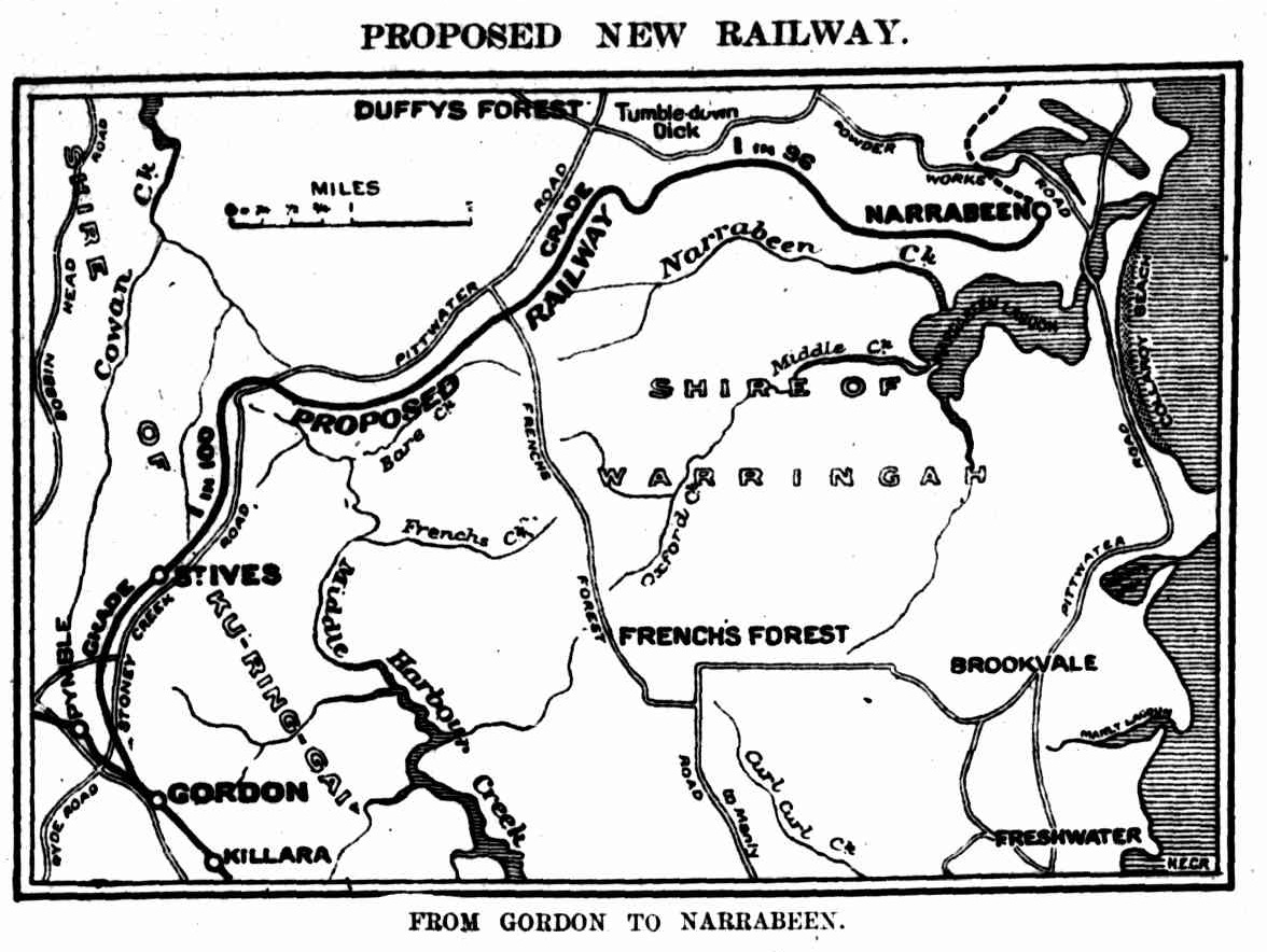
Image: sections from 1905 Parish Map of Narrabeen showing railway dotted line - that was rejected - and 'The Sugarloaf - this section at Terrey Hills part of map also shows 'James Terrey & Philip Spies' owning section of 640 acres previously held by Obadiah Terrey
In 1924:
FUTURE CITY.
GREAT CHANGES.
Electric Railways.
MR. BRADFIELD'S ADDRESS.
The extraordinary changes that Sydney and its environs will undergo, consequent upon the construction of the bridge and the City Railway, and the carrying out of the suburban railway electrification proposals, were described in a fascinating illustrated address in the Royal Colonial Institute last night by the Chief Government Engineer for the bridge and city transit (Mr. Bradfield). Sir Alfred Meeks, M.L.C., presided over an audience that crowded the hall to the doors. Men had to stand.
Mr. Bradfield referred at the outset to the bridge. "Our Isolation," he said, "Is our great drawback. We can and must reach the hub of the Empire, London, from Sydney within three weeks if we are to progress as we should, and such vessels as the Aquitania and Berengaria will trade to Sydney and make this possible within the next 20 years. The headway under the bridge will fixed at 170 feet, to provide for the leviathans of the future which will trade to Sydney."
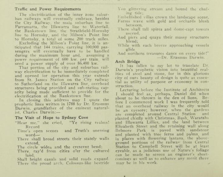
He illustrated the exiting steam railways and said that those within the suburban area. i.e., between the Hawkesbury and Nepean rivers and the coast would be electrified. "The first to be electrified," he added, "will be the railway from Sydney to Waterfall, with the spur line, Loftus to National Park; whilst the Sutherland to Cronulla tramway will, at no distant date, be remodelled into an electric railway. The electrification of the railway, Sydney to Waterfall, is now in hand. The second railway to be electrified will be the Bankstown railway, whilst the railways Sydney to Parramatta, Sydney to Hornsby, via Strathfield, and Hornsby via the bridge to the city, will follow, and afterwards the railways in the whole of the suburban area, to Campbelltown, Penrith, Windsor, and the Hawkesbury River will be worked electrically.
Another Illustration showed the proposed electric railways which have already been approved by Parliament, viz., the city railway, the eastern suburbs railway, the Western suburbs railway, and the Sydney Harbour Bridge, with its connecting railways from Wynyard-square to Bay Road Station.
"A railway," he added, "will extend from Athol through Mosman, via the bridge, into the city, whilst Manly, Narrabeen, and Pittwater will also be connected to the city via the bridge, and it will be seen at a glance how the bridge and these railways will open up the northern suburbs, and give them direct railway communication with the city and southern suburbs. To-day it takes 84 minutes to reach the G.P.O. from Narrabeen by tram, boat, and the George-street tram, but via Mosman and the bridge by electric train it would take only half an hour. Manly to-day is about 40 minutes distant from the G.P.O. by boat and the George-street tram; via the bridge, with a non-stop train, it would take 18 minutes, unless, as often happens, the slow trains stop at the stations, but the through trains frequently stop between stations. (Laughter.)
From Spit Junction by tram, the Mosman ferry, and the George-street tram, the time occupied in travelling, to the G.P.O, is 38 minutes, whilst via the bridge the time from the Spit Junction to the G.P.O. should not exceed 10 minutes with an electric railway service stopping at the intermediate stations also. From Bay Road Station, on the North Shore line, to-day it takes 30 minutes to reach Central Station; when the bridge is opened for traffic it will take but 12 minutes. Eastwood and the stations beyond, via the proposed East-wood St. Leonards railway, will he two miles nearer the General Post Office via the bridge than via the Central Station, whilst Hornsby and all stations beyond will be 7½ miles nearer the G.P.O. via the bridge than via Central Station.
"As the railways are constructed to Cremorne, Mosman, Athol, Manly, Narrabeen, Pittwater, etc., the stations will provide for goods traffic as well as for passengers, and the distribution of coal, wood, meat, agricultural produce, fruit, etc., will be expedited and considerably cheapened, whilst the city merchant will be able to forward the daily purchases by rail to suitable centres, and distribute them from these centres to the purchaser, saving not only time, but money to both purchaser and merchant.
"When the. break of gauge question is settled, the transcontinental express will start at, say, Rockhampton on its run of 3880 miles to Fremantle, and will pass through Sydney, via the Sydney Harbour Bridge, thus shortening the distance by several miles. The same carriages will run right through, steam and electric locomotives only being changed at various pre-arranged stopping places, Sydney becoming, as it were, a wayside station. The bridge is destined to carry this traffic."
"It is anticipated that electric trains will be in operation on the city railway as far as St. James's station in 1925 and that the Illawarra railway will be electrified to Waterfall.
A bird's-eye view showed Sydney of the future. It also showed the scheme of wharfage proposed for Sydney, also Darling Harbour reclaimed as far as Bathurst-street, Pyrmont Bridge removed, and a wide avenue from Balmain along the foreshores of the harbour to Bathurst-street. FUTURE CITY. (1924, March 19). The Sydney Morning Herald (NSW : 1842 - 1954), p. 13. Retrieved from http://nla.gov.au/nla.news-article16142285
In 1926:
Travelling Hours and Narrabeen
Although at the end of his recital on Saturday, Dr. Bradfield laughingly admitted that figures could be made to prove anything, he gave members of the Warringah Shire Council and the Town Planning Association something to discuss. He was referring to the harbor bridge making possible an electric railway to Narrabeen, and stated that adequate transport was an all-important factor in the development of a district. It was probable, he said, that in ten years the population of Warringah Shire would be 30,000, with probably 8000 people making the journey to and from the city dally. To-day it took 84 minutes to reach the G.P.O. from Narrabeen, but when the electric railway was laid down the time would be reduced to half-an-hour. This would mean a saving of at least 10,000 hours a day, and those hours, valued at the rate of one shilling, would amount to a huge total at the end of twelve months; a total, he added, amidst laughter, big enough to make the Warringah Shire Councillors consider the possibilities of an extra rate to carry out the improvements they have in mind. Travelling Hours and Narrabeen (1926, August 16). The Daily Telegraph (Sydney, NSW : 1883 - 1930), p. 6. Retrieved from http://nla.gov.au/nla.news-article246354906
However, this map shows the train would run to Manly, not Narrabeen:
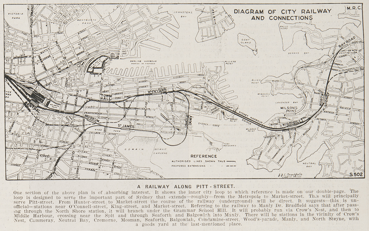
A Railway along Pitt Street - diagram of city railway and connections 1926. Text under the image reads as follows: One section of the above plan is of absorbing interest. It shows the inner city loop to which reference is made on our double-page. The loop is designed to serve the important part of Sydney that extends - roughly - from the Metropole to Market-street. This will principally serve Pitt-street. From Hunter-street to Market-street the course of the railway (underground) will be direct. It suggests - this is unofficial - stations near O'Connell-street, King-street, and Market-street. Referring to the railway to Manly Dr Bradfield says that after passing through the North Shore station, it will branch under the Grammar School Hill. It will probably run via Crow's Nest, and then to Middle Harbour, crossing near the Spit and through Seaforth and Balgowlah into Manly. There will be stations in the vicinity of Crow's Nest, Cammeray, Neutral Bay, Cremorne, Mosman, Seaforth, Balgowlah, Condamine-street. Wood's-parade, Manly, and North Steyne, with a goods yard at the last-mentioned place. From the collections of the State Library of New South Wales, Sydney Mail 1 September 1926 p14
Although Bradfield's plan included the city loop, an eastern suburbs line and a western suburbs line carried on a bridge to Balmain, the city loop was prioritised. Bradfield envisioned five city stations, with a through connection to North Sydney via a bridge. The loop design would avoid the delays that any terminating service would cause. His vision was ambitious, with up to 40 trains per hour per line, increased to 80 per hour for stations with their double or bifurcated platforms, and an estimated total of between 36,000 and 42,000 passengers per hour. His plan included the termination of the Balmain line at Wynyard and the eastern suburbs line at St James Station. Bradfield stressed the need for his service to run on a different set of lines than those already terminating at Central Station, which established two services: a city service and a country or intercity service. Power for the system was to be supplied from the White Bay Power Station, then in use for the tramways, with a series of substations around the network.
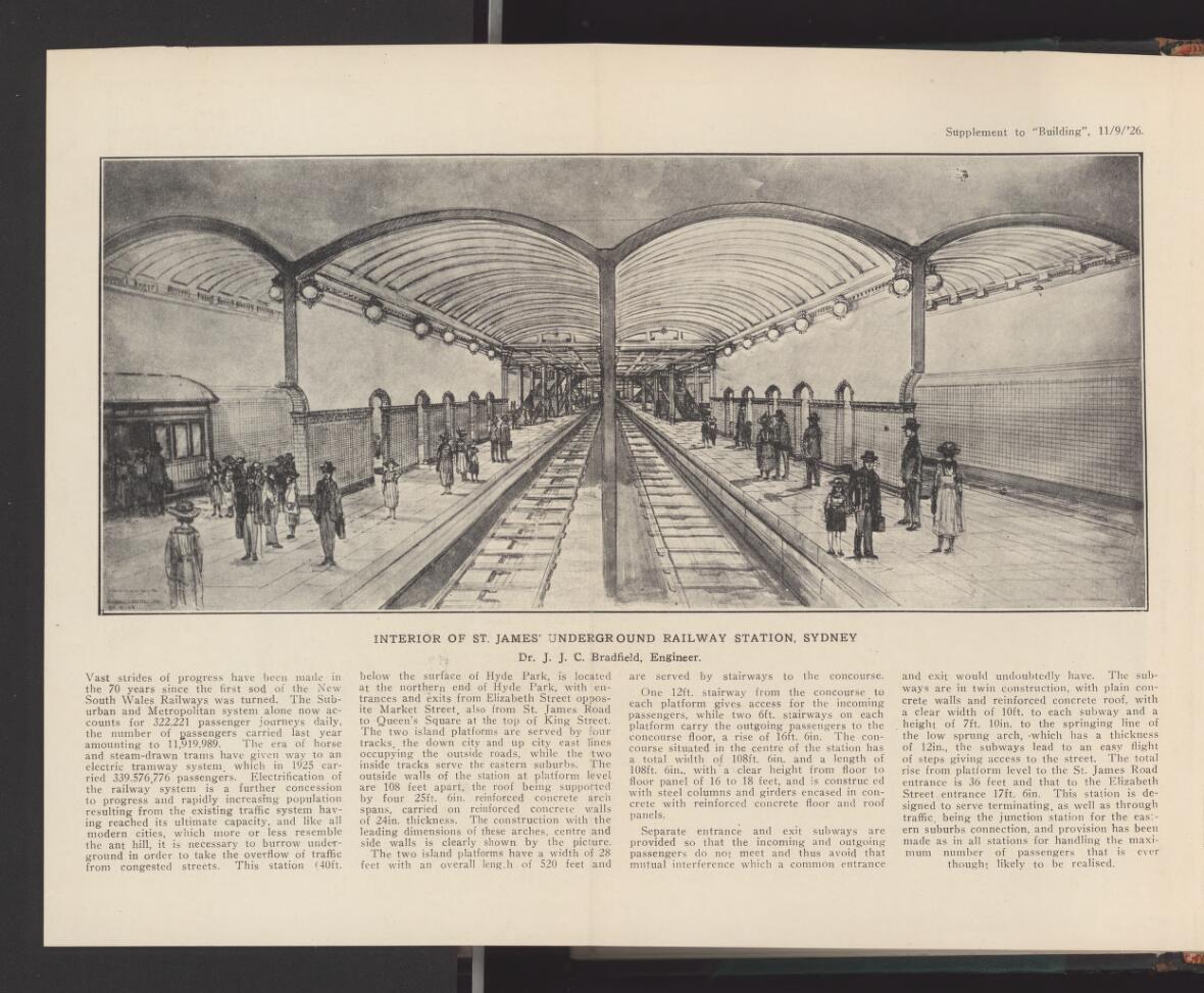
With the legislation for the bridge secured, work began in earnest on the railway that would connect to it. The scale of works was to be enormous and caused considerable disruption to the city for the next ten years. The work included four underground stations with two to be built with single levels – Museum with two platforms and St James with four – and the other two to have six platforms over two levels (Town Hall and Wynyard). A new electric station at Central was also to be built.
The first section started was the eastern portion of the loop between Central Station and St James Station at the northern end of Hyde Park and then on to Circular Quay, where it terminated in a dead end tunnel. With tunnelling work between Goulburn Street and Hyde Park, a cut-and-cover method was then employed. This involved the removal of much of the park down to the track level, with the infrastructure for the tracks, the electric wiring and the stations built before being covered over and the park, for which Norman Weekes had won a design competition, re-installed above. The excavated material was used to build up the southern approaches for the Harbour Bridge as well as tipped into Darling Harbour to reclaim more land. By mid-1925 much of the formwork, the arches for the stations, the connecting pedestrian tunnels and the platforms at Central were close to completion and work began on the western side.
Built in stages, the first City Circle stations to open were the heritage-listed Museum and St James, which both opened in December 1926 as part of the initial electrification of Sydney railways.
With the first sections opened, work concentrated on the more technically difficult western section, with the vast majority requiring deep tunnelling under city buildings. This section, including Town Hall and Wynyard stations, was progressed to correspond with the opening of the Harbour Bridge in 1932.
WYNYARD PARK BEFORE EXCAVATION FOR STATION, CITY CIRCLE, WYNYARD NSW: FL9267546 and FL9266379 courtesy NSW State Records
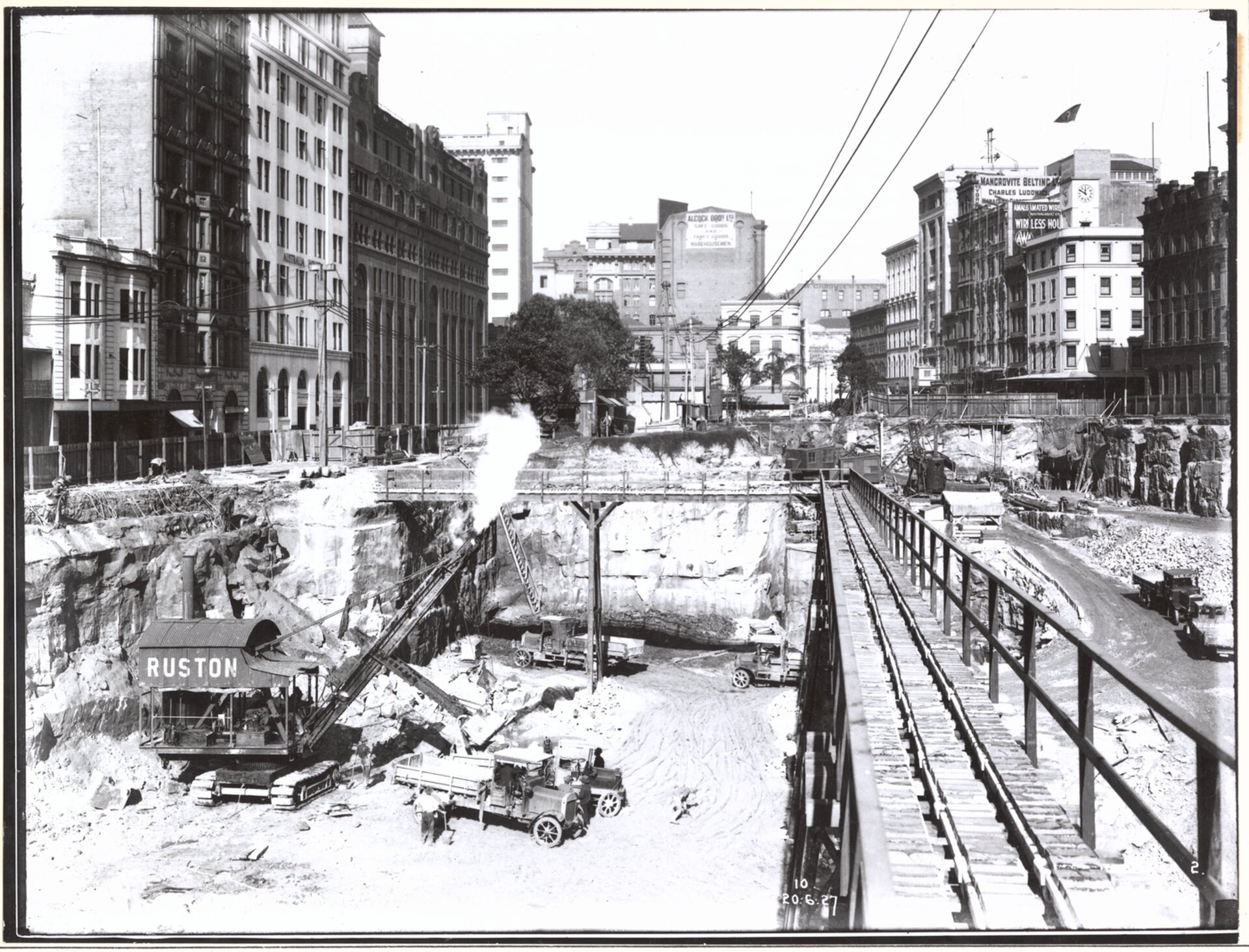
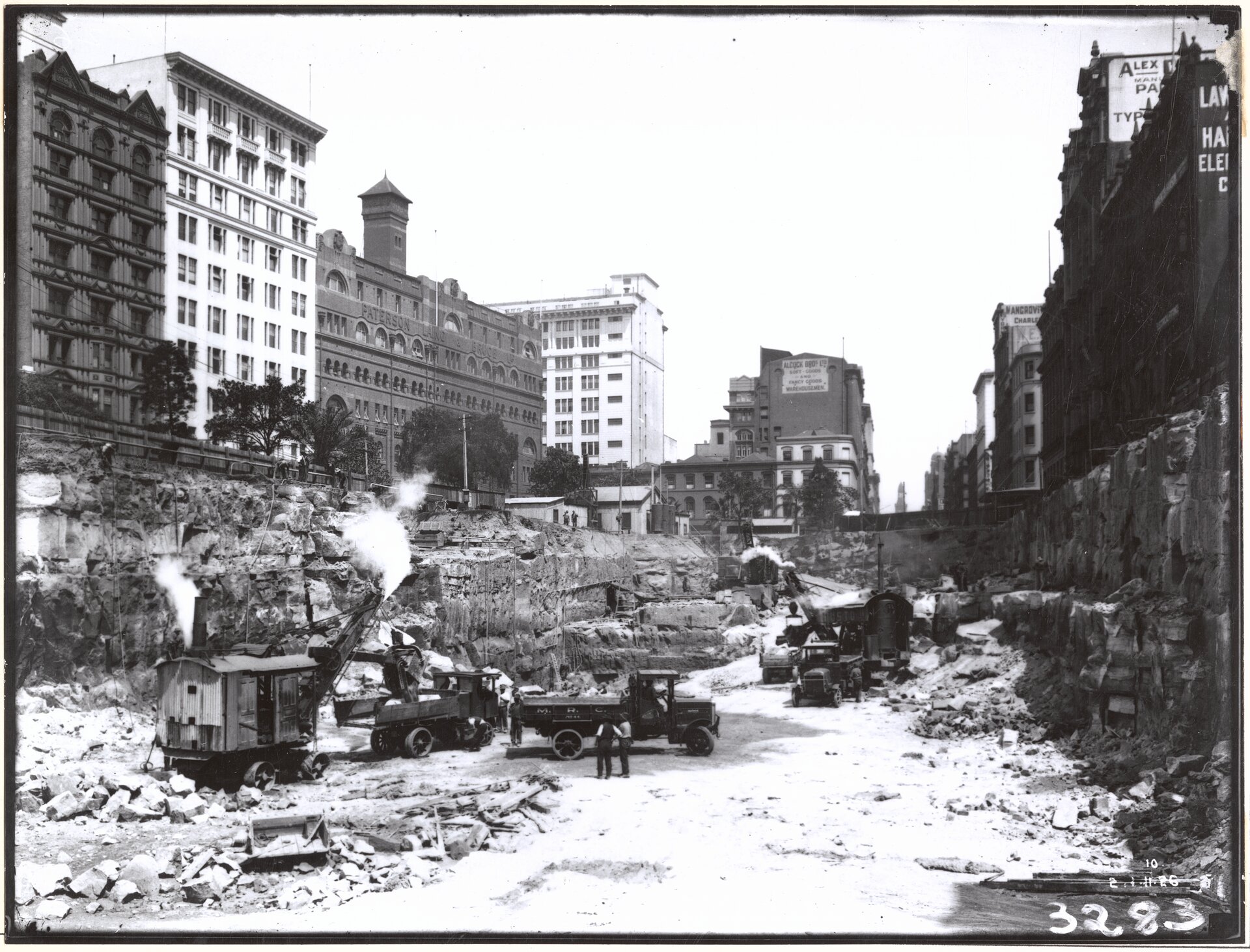
EXCAVATION FOR STATION, CITY CIRCLE, WYNYARD NSW 20-06-1927 to 20-06-1927 FL9266930 and FL9268143 courtesy NSW State Records
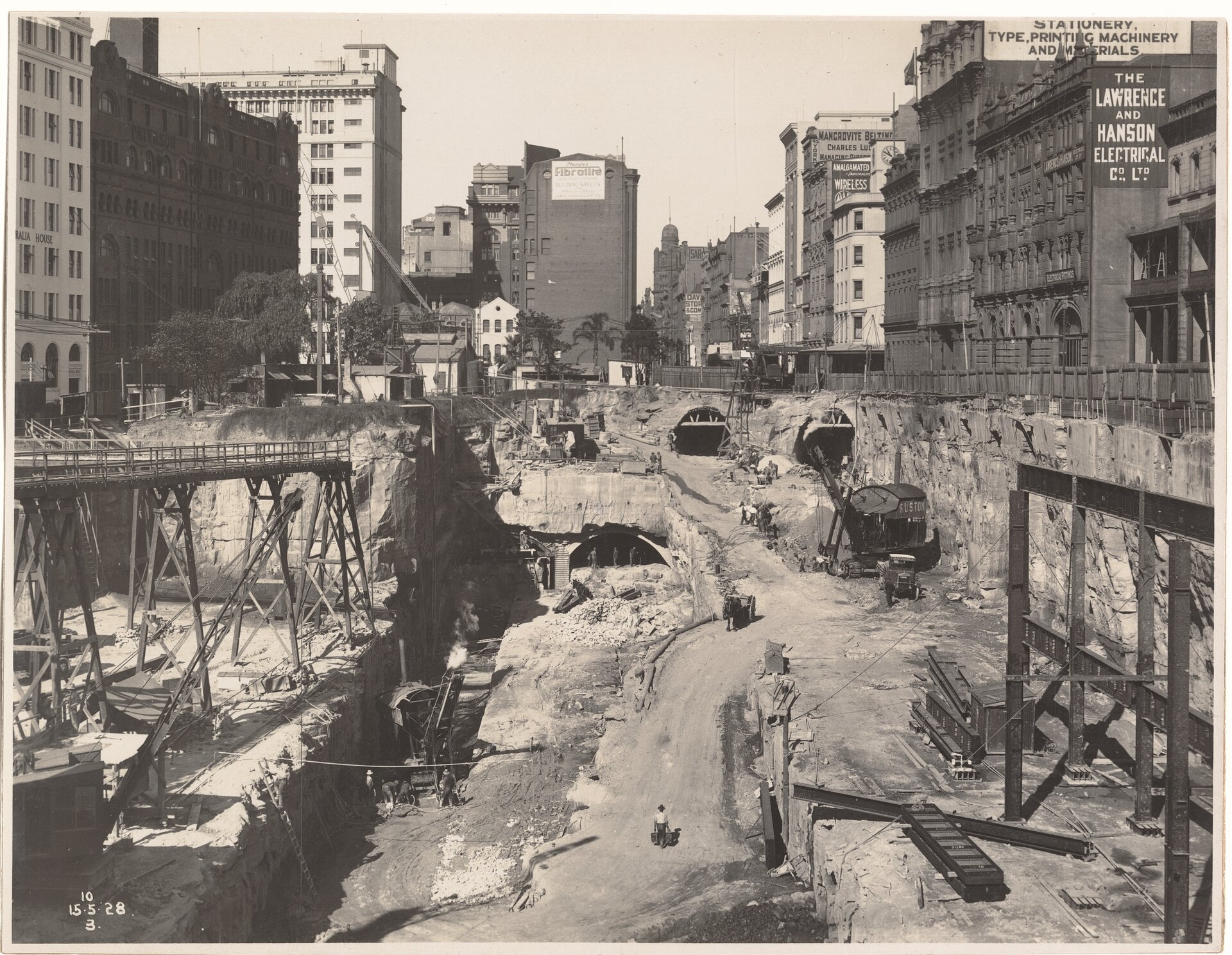
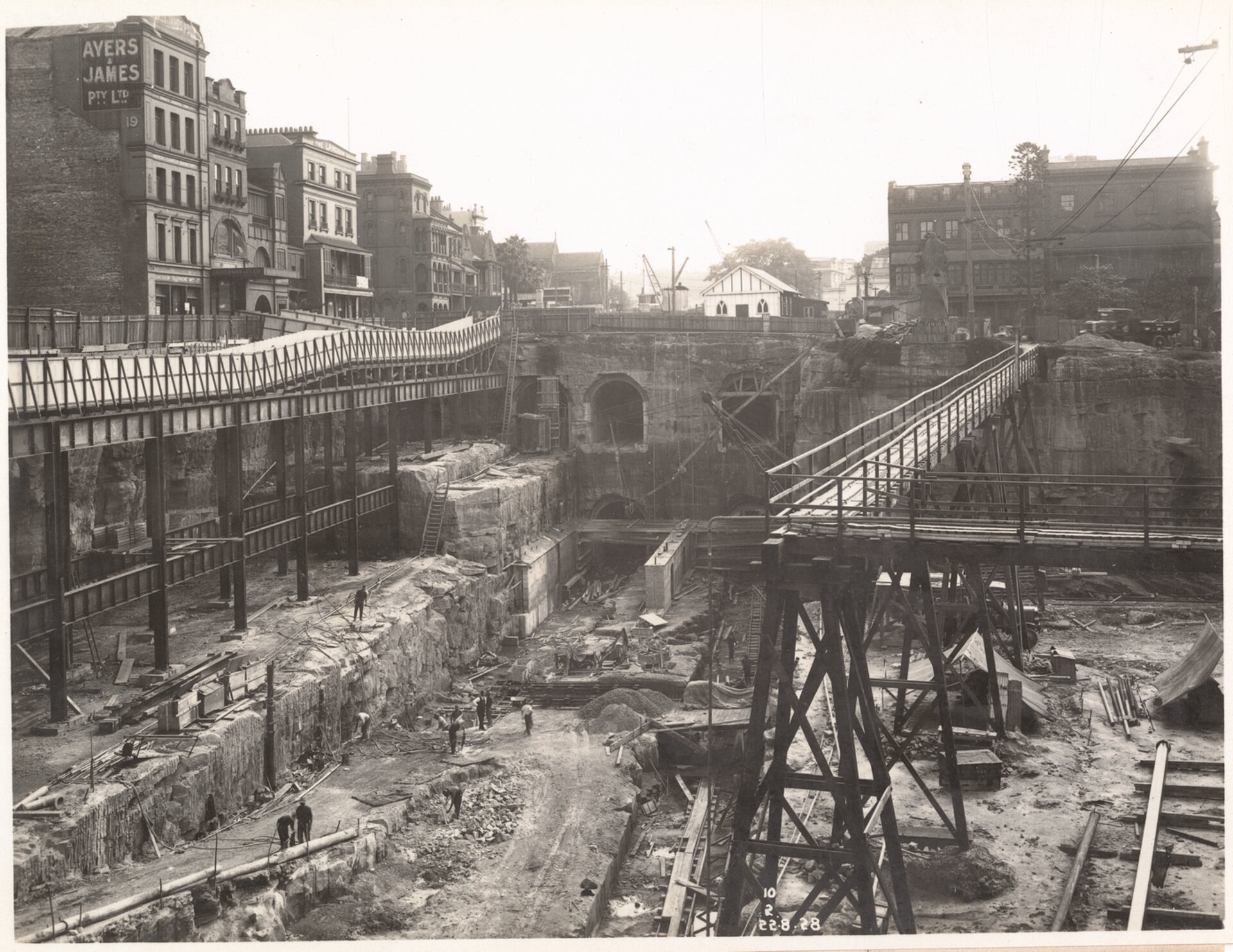
CONSTRUCTION OF STATION, CITY CIRCLE, WYNYARD NSW 15-05-1928 to 22-08-1928 FL9268215 and FL9269082,courtesy NSW State Records
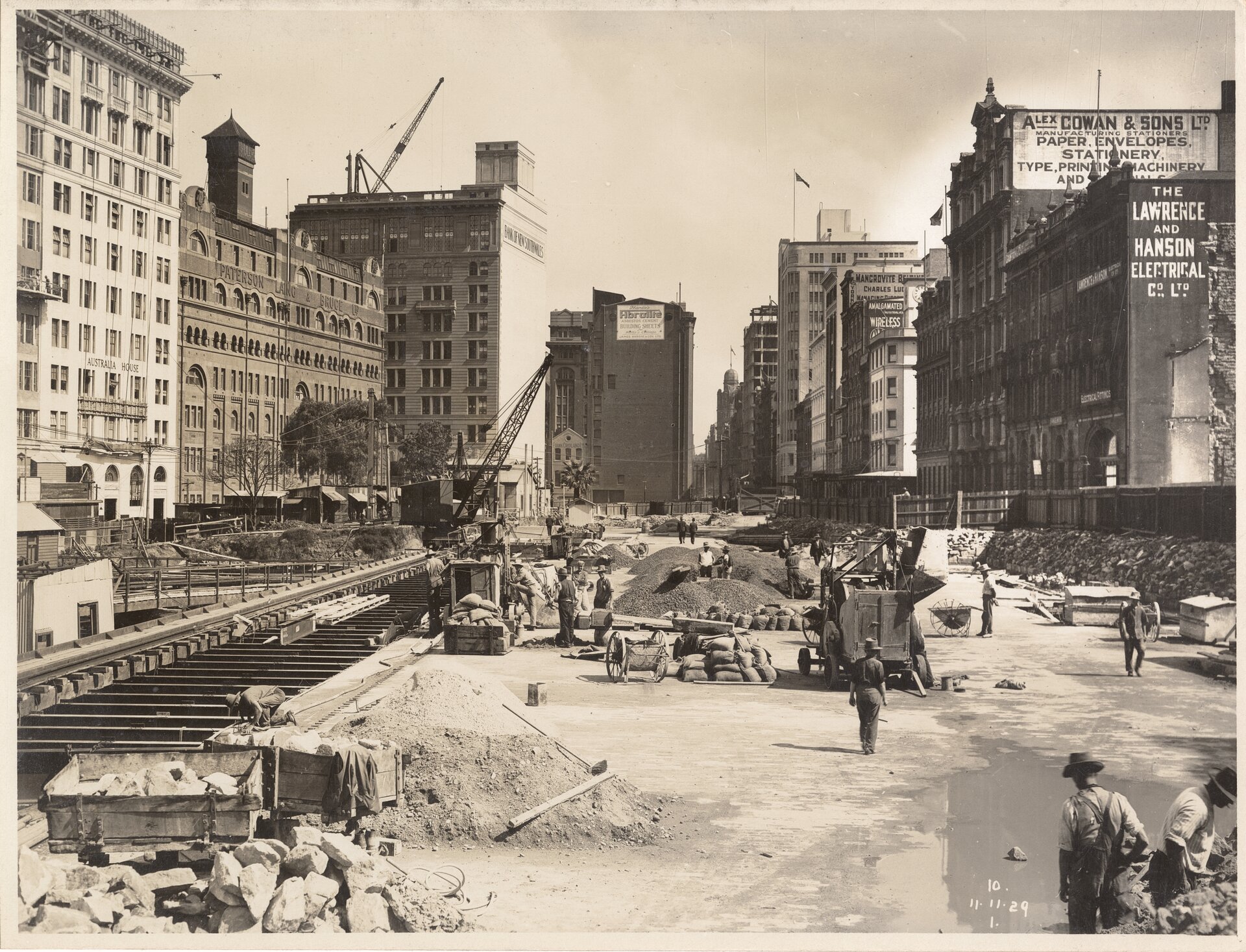
CONSTRUCTION OF STATION, CITY CIRCLE, WYNYARD NSW 11-11-1929 to 11-11-1929 FL9267914 courtesy NSW State Records
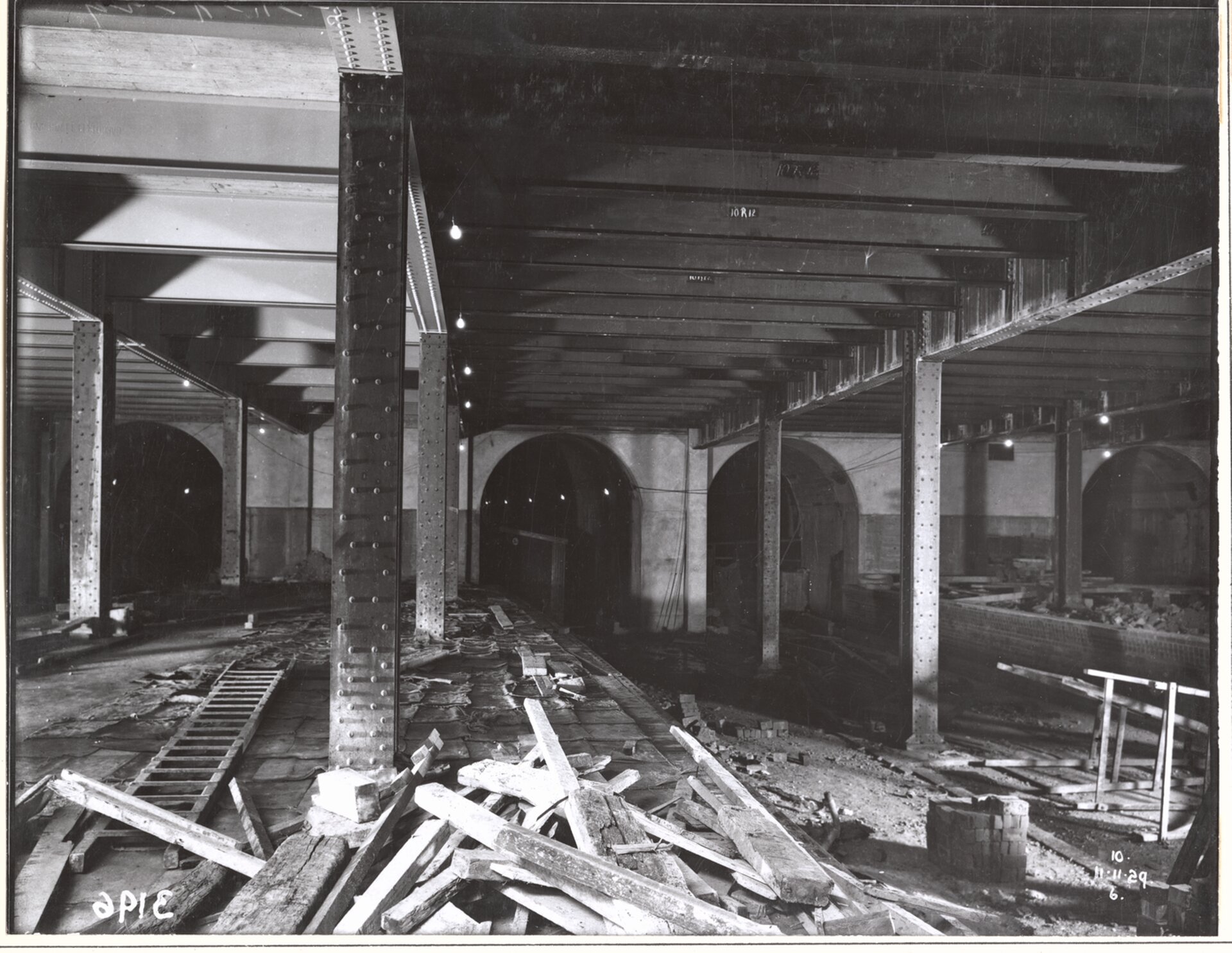
STATION FRAME AND TUNNEL PORTALS, CITY CIRCLE, WYNYARD NSW 11-11-1929 to 11-11-1929 FL9266429 courtesy NSW State Records
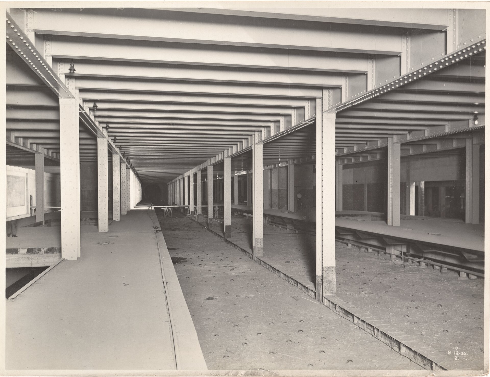
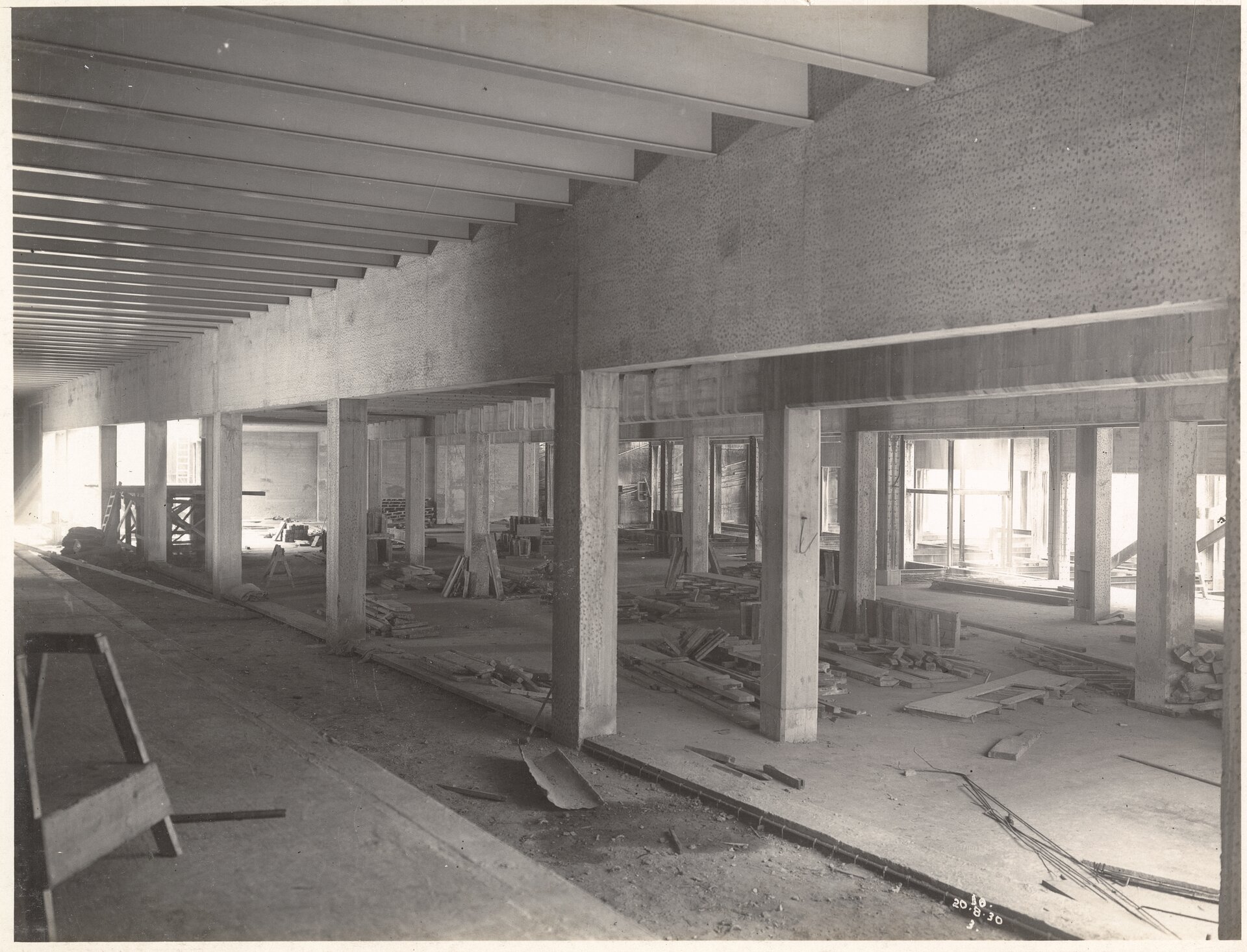
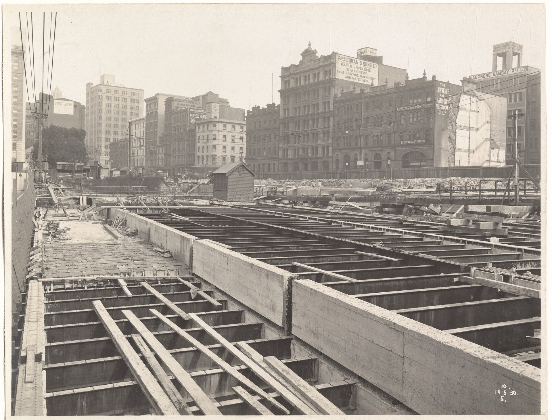
CONSTRUCTION OF STATION, CITY CIRCLE, WYNYARD NSW 19-05-1930 to 08-12-1930 FL9269633 and FL9268426, FL9269292 courtesy NSW State Records
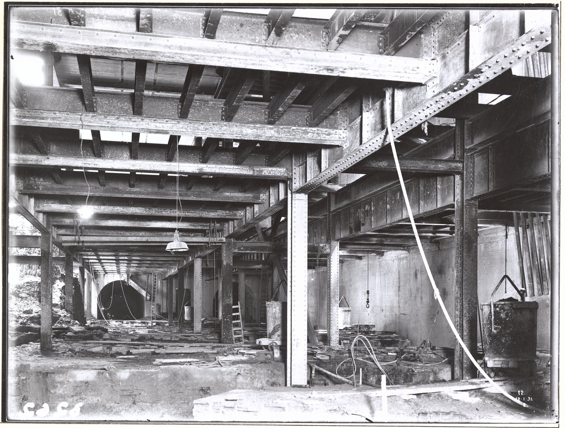
STATION FRAME AND TUNNEL PORTALS , CITY CIRCLE, WYNYARD NSW 12-01-1931 to 12-01-1931 FL9266616 courtesy NSW State Records
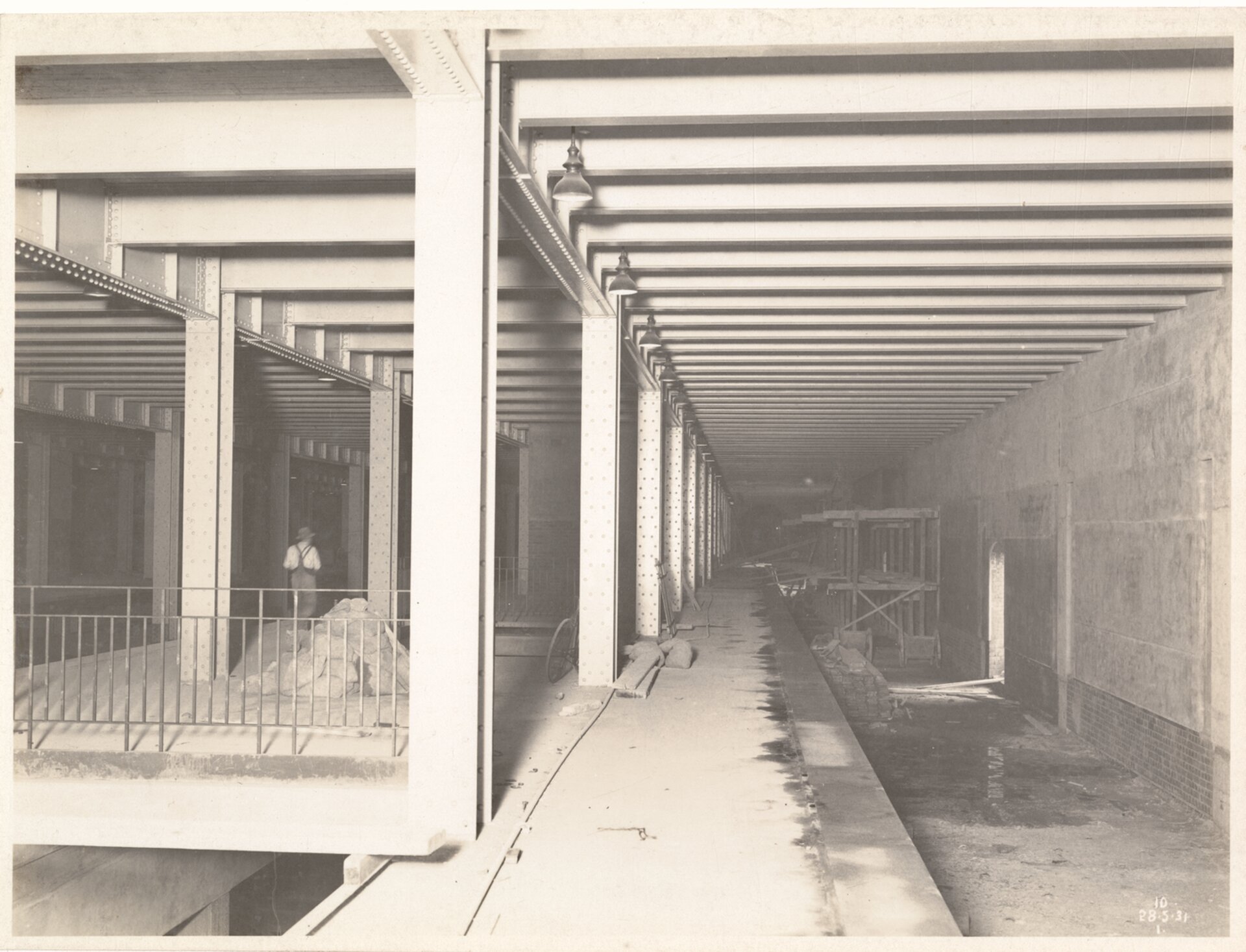
CONSTRUCTION OF STATION, NORTH SHORE, WYNYARD NSW 28-05-1931 to 28-05-1931 FL9267788 courtesy NSW State Records
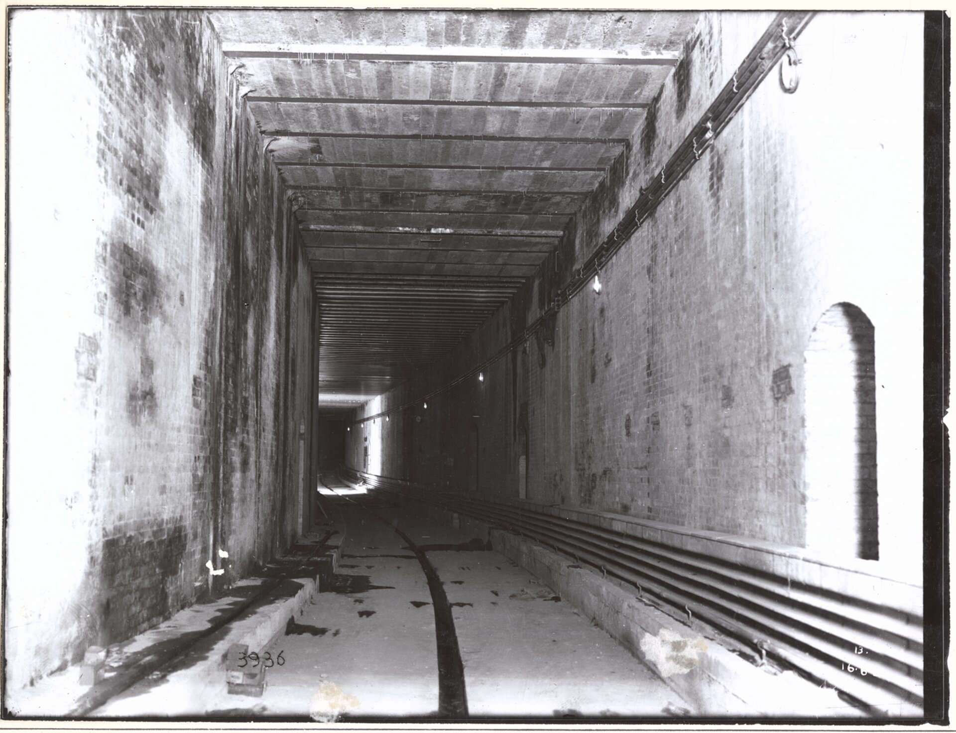
TUNNELS NORTH OF STATION, NORTH SHORE, WYNYARD NSW 16-06-1931 to 16-06-1931 FL9266343 courtesy NSW State Records
Work on the stations began in late 1925, with excavations at Wynyard Park underway. The site for the station at Town Hall was enclosed by a fence, with excavations starting the following year. Both stations were built using a steel framework and were designed to take multiple lines with each serving the city loop line as well as north shore lines. At Town Hall station there was also provision for platforms and tunnels at a deeper level to serve a proposed eastern suburbs line. By mid-1927 excavations for both stations were well underway, with the tunnels between both also under construction. As Wynyard Station progressed, work also started on a new headquarters for the railways, to be constructed over the station.
The stations at Town Hall and Wynyard, as well as the tunnelling between them, were completed in late 1931 and opened to the public on February 28th 1932, just three weeks before the Sydney Harbour Bridge. The opening of the Bridge on March 19th was also the day the first train ran across it with passengers. A special train left Wynyard at 12.30pm with official guests and 600 passengers to North Sydney, before returning to Wynyard. Regular passenger services began the following day.
Although Bradfield had advocated for an elevated railway station at Circular Quay as an integral component of his city loop, costs and the outbreak of World War II meant the completion of his dream was postponed. The financial cost of war had interceded again.
The tunnels were used during the war as public air raid shelters at St James (parts of which remain in the disused tunnels at the station) and as secure control centres for the armed forces at the Circular Quay end.
Although preliminary planning had begun in 1936, it was not until a new supervisory committee was formed in 1948 that plans for Circular Quay were finalised. The station would now include a roadway overhead for a new expressway connection to the Harbour Bridge. The original concept for a solid-wall design station building was also modified to a more open plan with views through at ground level and track level to and from the Harbour. Work began on the viaduct to carry the tracks and the roadway in 1946. The station was finally opened on January 20th 1956, with the first regular service around the completed city loop running two days later.
But where was the 'train to Narrabeen' or Manly meant to commence from?
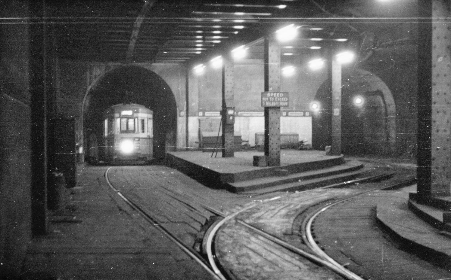
Wynyard Station originally boasted six platforms, with one to four on the upper floor and five and six below. The original intention was that Platforms 1 and 2, located adjacent to platforms 3 and 4, would eventually serve the eastern pair of railway tracks across the Harbour Bridge for a proposed railway line to our area. In the interim, with construction yet to begin on a Beaches line due to lack of funds, they were used as a terminus for North Shore tram services on Sydney's tram network, a service that operated over those tracks from the bridge's opening in 1932 until 1958.
These tram services were withdrawn in 1958 and platforms one and two walled off, and converted into the carpark for the now demolished Menzies Hotel. Interestingly, all that separated the trams from the trains was a wooden fence which passengers could see over.
The tunnels were accessed from Wynyard Lane where a descending ramp was cut west under Wynyard Park to the disused platforms. The car park used both tunnels north from the former platforms to an exit cut in from Cumberland Street just south of Essex Street. The Wynyard Lane Car Park was closed in October 2016 to make way for the mixed-use Wynyard Place development which would obstruct the entrance ramp to the tunnels.
The remainder of the tunnels north of the car park exit were walled off as were the northern portals on the Harbour Bridge. North of the portals, two additional road lanes were built above the old tramway as part of the Cahill Expressway. The disused tunnels and ramp that formerly connected the station to the eastern tram tracks can still be seen from the pedestrian path along the east side of the bridge, mirroring those still in use to the west of the bridge.
Below runs a great new video from the BackTracks channel, which has been running a series on the trams of Sydney. Published June 9th 2023, 'Sydney's Abandoned Underground Tram Station' shares insights the underground railway station that ended up being a tram station that closed in 1958 to reopen as a car park in 1964 only to close itself in 2018 and then briefly re open to the public a light installation as part of the VIVID Festival in 2023.
References - Extras
- Roads To Pittwater: The Mona Vale Road
- Sydney Harbour Bridge Celebrates 85th Birthday: A Few Pittwater Connections
- Dunn, Mark, City Underground, Dictionary of Sydney, 2017, http://dictionaryofsydney.org/entry/city_underground
- Tram Memorabilia - Historic Daylight Run For Sydney Light Rail Begins 80 Years After Last Tram To Narrabeen Closed
Above all from - Federated Builders' Association of Australia & Master Builders' Federation of Australia. (September 11, 1926). The Construction of Sydney City Railway DR. BRADFIELD LECTURES, Building : the magazine for the architect, builder, property owner and merchant Retrieved from http://nla.gov.au/nla.obj-310361291
.jpg?timestamp=1685786155078)
.jpg?timestamp=1685786190278)
Sydney Grows Its Own Tropical Fruit (1938, July 14). The Sun (Sydney, NSW : 1910 - 1954), p. 13 (LATE FINAL EXTRA). Retrieved from http://nla.gov.au/nla.news-article229136630