SES Warns Of Flood Risk Following La Nina Declaration
September 13, 2022
NSW residents are again being urged to prepare for the risk of flooding, following the declaration of a La Nina event by the Bureau of Meteorology (BoM) today.
NSW State Emergency Service (NSW SES) Commissioner Carlene York said while the agency is well-prepared for another busy period, it is critically important for people to take responsibility and be prepared.
“Today’s declaration means eastern Australia is heading into a third consecutive La Nina season, which presents unique risks and challenges,” Commissioner York said.
“There is already wet soil, high rivers and full dams right across our State, and with more rain on the horizon comes the very real possibility of flooding.
“If you live in a flood-prone area, I urge you to take steps to prepare now. Make sure you know your risk, have an up-to-date emergency plan and emergency kit. Preparing early will save you vital time during an emergency.”
The NSW SES recorded its busiest 12-month period on record between 1 July 2021 and 30 June 2022, with multiple communities across the State experiencing major flooding.
“Over the last year more than 5,000 flood-related messages, including evacuation orders, evacuation warnings, flood bulletins and return safely notifications, were released by our teams of staff and volunteers,” Commissioner York said.
During the recent June-July flood event, a flood-related message was issued by the NSW SES on average every four minutes.
“We know that time is crucial in emergencies. If you receive an evacuation warning or order you need to already have a plan in place and be ready to act immediately,” Commissioner York said.
On September 30th the NSW SES will transition to the Australian Warning System. The three new tiers of warning will be Advice, Watch and Act, and Emergency Warning, and each warning will contain a clear action statement to help residents make safe decisions.
Warning levels and action statements
There are three levels within the AWS - Advice, Watch & Act and Emergency Warning. For each level, there are a series of clear action statements to guide positive action by the community. These include ‘stay informed’, ‘prepare to evacuate’ and ‘move to higher ground’ as shown below:
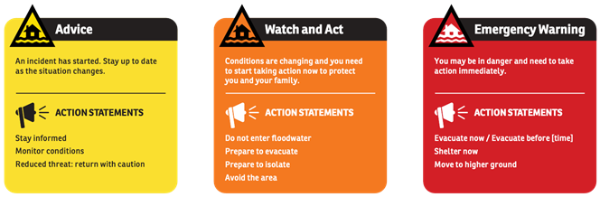
Advice - an incident has started. Stay up to date in case the situation changes.
- Stay informed
- Monitor conditions
- Reduced threat: return with caution
Watch and Act - conditions are changing and you need to start taking action now to protect you and your family.
- Do not enter floodwater
- Prepare to evacuate
- Prepare to isolate
- Avoid the area
Emergency Warning - the highest level of warning. You may be in danger and need to take action immediately.
- Evacuate now / Evacuate before [time]
- Shelter now
- Move to higher ground
Each warning has three components:
- Location + Hazard: The location and the type of hazard impacting the community (e.g. Lismore flooding).
- Action statement: For each warning level there are a range of action statements to guide protective action by the community. These statements evolve as the warning levels increase in severity. Statements range from ‘stay informed’ at the Advice level, to ‘prepare to evacuate’ at the Watch and Act level, to ‘evacuate now’ in the Emergency Warning level. As the situation changes and the threat is reduced, the level of warning will decrease accordingly.
- The warning level: The severity of the natural hazard event based on the consequence to the community.
Local warnings for your community
The NSW SES utilises a range of sources to build detailed flood intelligence within local communities – including information from flood studies and historical flood data. As part of the transition to the Australian Warning System, the NSW SES has increased flexibility to tailor warnings at the community level, based on the expected consequences of severe weather events.
Accessing NSW SES warnings
Impacted communities will continue to receive flood warnings through the NSW SES website, NSW SES social media channels and by listening to local ABC radio stations.
The NSW SES is also developing an all-hazards warning platform to provide an additional channel for communities to access important warning information.
This Storm Season, NSW SES need you to be aware and prepared for storms.
While storms can happen at any time of the year, between October and March, NSW sees increased chances of strong winds and heavy rain, which risks floods and flash floods.
This year, the Bureau of Meteorology has forecast that this Storm Season will be wetter than average. Unfortunately, this means we will see more instances of heavy rain and the very real risk of riverine and flash flooding.
NSW SES volunteers are always ready and willing to assist local communities through storms and floods. But that doesn’t mean you shouldn’t take the time to prepare to protect your family, animals, household and property. So, are you ready for Storm Season?
Plan Now
You can put together an Emergency Plan for your home and/or business.
One of the most important things to do is to plan now for possible severe weather, so that you know what to do in the event of a severe storm.
Chat with your family, household, friends and neighbours about your emergency plan.
Practice your Emergency Plan and update it when things change.
Get your home ready to help reduce damage caused by severe storms.
Prepare your home by doing these simple tasks:
- Maintain your yard and balcony
- Clean your gutters, downpipes and drains
- Trim trees and branches
- Keep your roof in good condition
- Check your insurance policy
- Make an Emergency Plan
- Prepare an Emergency Kit (Grab-and-go bag)
- Listen to your local radio station for weather warnings
Pets and other animals are important members of the family or household. Make sure your pets and animals are ready for Storm Season and visit Get Ready Animals
Look out for each other
We may be in a situation where we care for children, elderly, people with different abilities or people from different language backgrounds. It is important to ensure we share the Get Ready message with everyone.
It could be as simple as helping a neighbour with trimming their trees or sitting down with extended family to do an Emergency Plan. Australians are known for mateship and helping each other during a crisis. Looking out for each other before severe weather means we can respond and recover better as a community.
Emergency kit
Get Your Kit Together - put together an Emergency Kit today. An Emergency Kit can help save precious time in an emergency situation. It provides items you might need if you lose power or need to leave your home in a hurry.
Your emergency kit contents:
- Portable radio with spare batteries
- Torch with spare batteries
- First aid kit (with supplies necessary for your household)
- Candles and waterproof matches
- Important papers including emergency contact numbers
- Copy of any Home Emergency Plans
- Waterproof bag for valuables
When leaving or evacuating your property, place in your emergency kit:
- A good supply of required medications
- Any special requirements and supplies for babies, the disabled, infirm and/or elderly
- Appropriate clothing and footwear
- Fresh food and drinking water
Keep your emergency kit in a waterproof storage container.
On a regular basis, check your emergency kit (remember to check use-by dates on batteries and gloves) and restock items if you need to.
Also, keep a list of emergency numbers near your phone or on your fridge.
More information about the new warning system is available at: www.ses.nsw.gov.au/warnings.
By Mel Taylor, Associate Professor, Macquarie University and Katharine Haynes, Honorary Senior Research Fellow, University of Wollongong
Hearts sank along the Australian east coast this week when the Bureau of Meteorology announced a third consecutive La Niña was likely this year. La Niña weather events typically deliver above-average rainfall in spring and summer.
But the last two La Niñas mean our catchments are already full. Dams are at capacity, soils are saturated and rivers are high. In some cases, there’s nowhere for the rains to go except over land.
Over the past 18 months, many communities have been hit by floods – some more than once. For these residents, the prospect of a third La Niña will be extremely concerning. And some people who’ve never experienced floods may now be at risk.
Our current research project is examining the experiences of flood-hit communities in New South Wales and Queensland – and our interviews have already yielded useful insights. So let’s take a look at what we should be thinking about now as another wet summer looms.
Water isn’t always fun
Floods are among the deadliest natural hazards in Australia. Yet in Australian culture, water often equates to fun. From a young age we’re taught to swim, enjoy and “master” the dangers that water poses.
So during floods we often see risky behaviours such as driving and playing in dangerous water.
Recent floods, however, brought home the reality of the threat. Few could forget images of frightened families being winched off roofs by helicopter, water rushing from spilling dams and everyday people rescuing their neighbours.
The NSW government on Wednesday released an independent report into this year’s floods. It examined flooding from February to April and again in July – mostly around the Northern Rivers, Sydney’s Hawkesbury-Nepean and the central to north coasts.
The report contained troubling statistics, including:
- nine people tragically died
- 7,700 people sought emergency accommodation
- 14,600 homes were damaged
- 5,300 homes were left uninhabitable.
Releasing the report, NSW Premier Dominic Perrottet said up to 40,000 Western Sydney residents risked flood evacuation by 2040, if flood conditions similar to those in July were repeated and no mitigation action was taken.
The inquiry revealed a central theme: the need for a renewed and stronger emphasis on sustained disaster preparedness. Otherwise, as the report noted, the emergency response becomes harder:
Preparedness is discussed in relation to emergency management and our natural and built environment. But an important component of preparedness is at a personal or family level. Failure to prepare at this level makes preparations at other levels more difficult and expensive.
‘Don’t worry. Your house won’t get wet’
Our current research is examining the experiences of those affected by this year’s floods to gather insights on preparedness and response. Participants can take part in an interview, a survey or both.
Our interviews are already providing useful insights. They include the possibility that prior experience of flood, and the well-meaning reassurances of others, can hinder preparations. As one respondent said:
the house, having been built on a mound, has never been flooded and that’s why my neighbour said, ‘Don’t worry. Your house won’t get wet. It’s never got wet in 70 years’. But this was unprecedented.
With another wet summer likely, interviewees are starting to see major flooding as a “new normal” rather than a once-in-a-lifetime experience. This is causing them to question the future of their communities. As another respondent told us:
that’s the part that I’m struggling with now is that it feels like it’s unviable to live here because there’s no security, and when you take away people’s security, your life tends to unravel.
We hope our research will influence policy and practice on flood preparation, community engagement and risk messaging, and shed light on more permanent changes required.
Be prepared
So what should you do if flooding is forecast and you need to evacuate? Here’s what experts recommend:
- identify the safest route to your nearest safe location and leave well before roads flood
- move vehicles, valuables, outdoor equipment, garbage and poisons to higher locations
- enact safety plans for pets and other animals
- take medications, identification and important documents with you - have them stored in a sealed waterproof bag of some sort
- tell friends, family and neighbours of your plans
- know where to go for information. Monitor alerts and stay aware of changing situations
- keep your mobile phone charged and have at least half a tank of fuel in your vehicle
- turn off electricity, gas, and water at the mains before you leave.
Of course, flood preparation should not be left until the last minute. Now is a good time to think about what might happen in the months ahead. Things you can do now include:
- clean up outside and inside, move or secure items that could float or create a hazard
- move valued possession to higher places in your home
- pack an emergency bag and keep it at the ready
- consider which friends or family you might stay with if needed.
For further advice, head to the website of your state’s emergency service agencies.
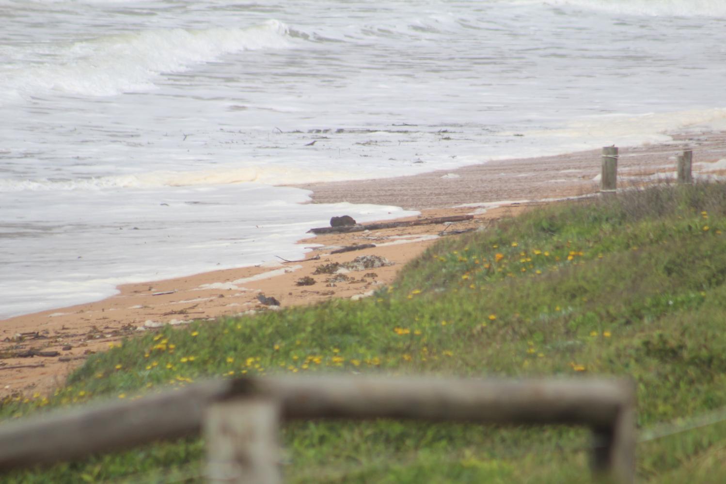
Warriewood earlier this year. Photo: Joe Mills
Thinking long-term
Climate change will exacerbate floods and other natural hazards. Communities must be supported to prepare as best they can.
More permanent measures are also needed, such as land buybacks to move people out of flood-prone areas. And importantly, planning systems must ensure we don’t keep building on floodplains.
Our approach to disaster readiness will continue to change. Already, experts are providing advice on matters such as emotional preparedness and recovery in the aftermath.
One thing is clear: in the face of the increasing disaster threat, temporary and seasonal preparations are no longer enough.