May 12, 2022
by Mitchell Harley, Scientia Senior Lecturer, UNSW Sydney and Gerd Masselink, Professor of Coastal Geomorphology, University of Plymouth
The Conversation: Environmental scientists see flora, fauna and phenomena the rest of us rarely do. In this series, we’ve invited them to share their unique photos from the field.
Extreme storms can cause devastating erosion and leave beachfront houses teetering on cliff edges. But our new research, published today, finds storms might also help replenish beaches by bringing in new sand from deeper waters.
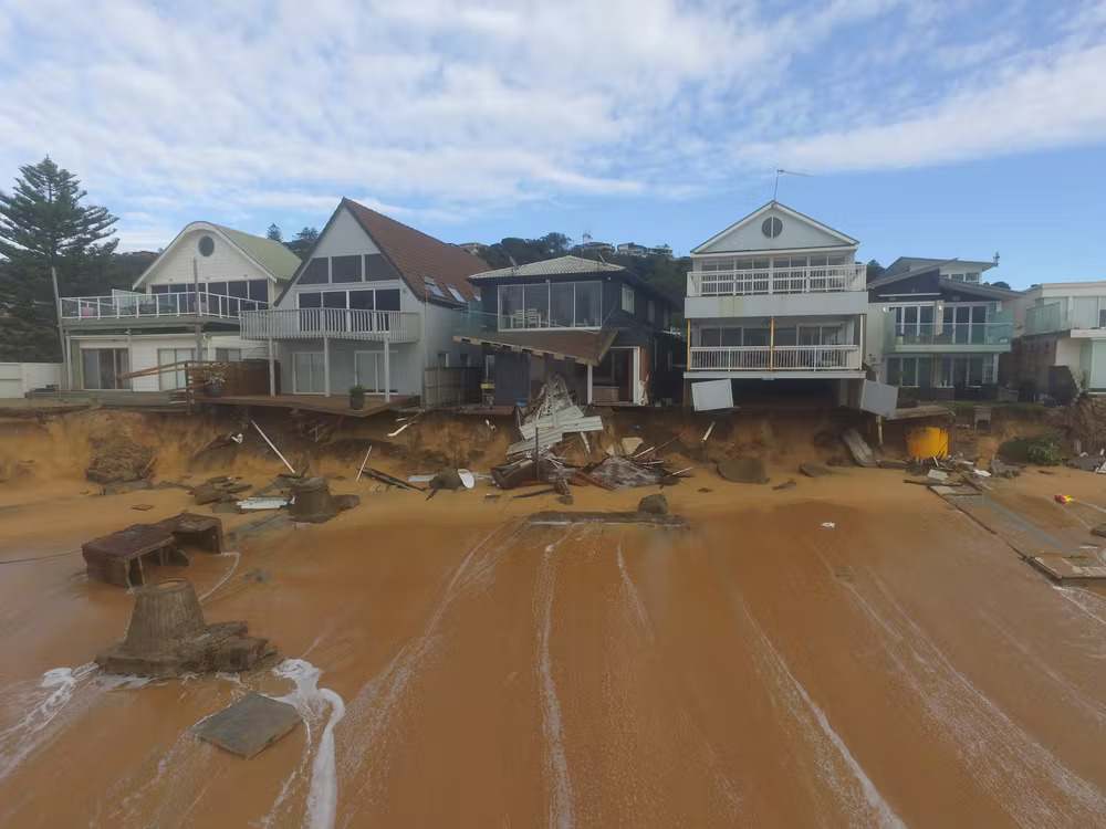
We studied three extreme storms in Australia, the United Kingdom and Mexico. One, in Sydney in 2016, famously ripped a swimming pool away from a property overlooking the coastline.
For the first time, we’re able to show just how much new sand can be added to a beach in a single storm alone – over 400,000 cubic metres in some cases. That’s equivalent to the typical volumes of sand engineers use to nourish beaches artificially.
As sea levels rise, this natural form of beach replenishment might be an important factor in offsetting some of the damaging effects of climate change on beaches. Yet, with little knowledge of exactly how much sand is moving around offshore, predicting the future of beaches in the coming decades is extremely difficult.
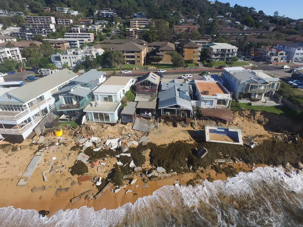
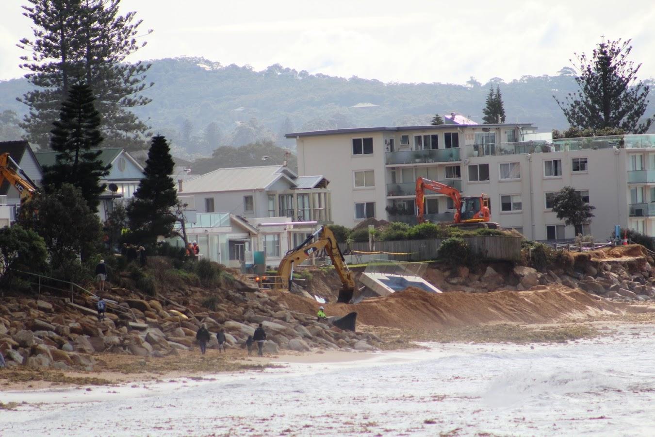
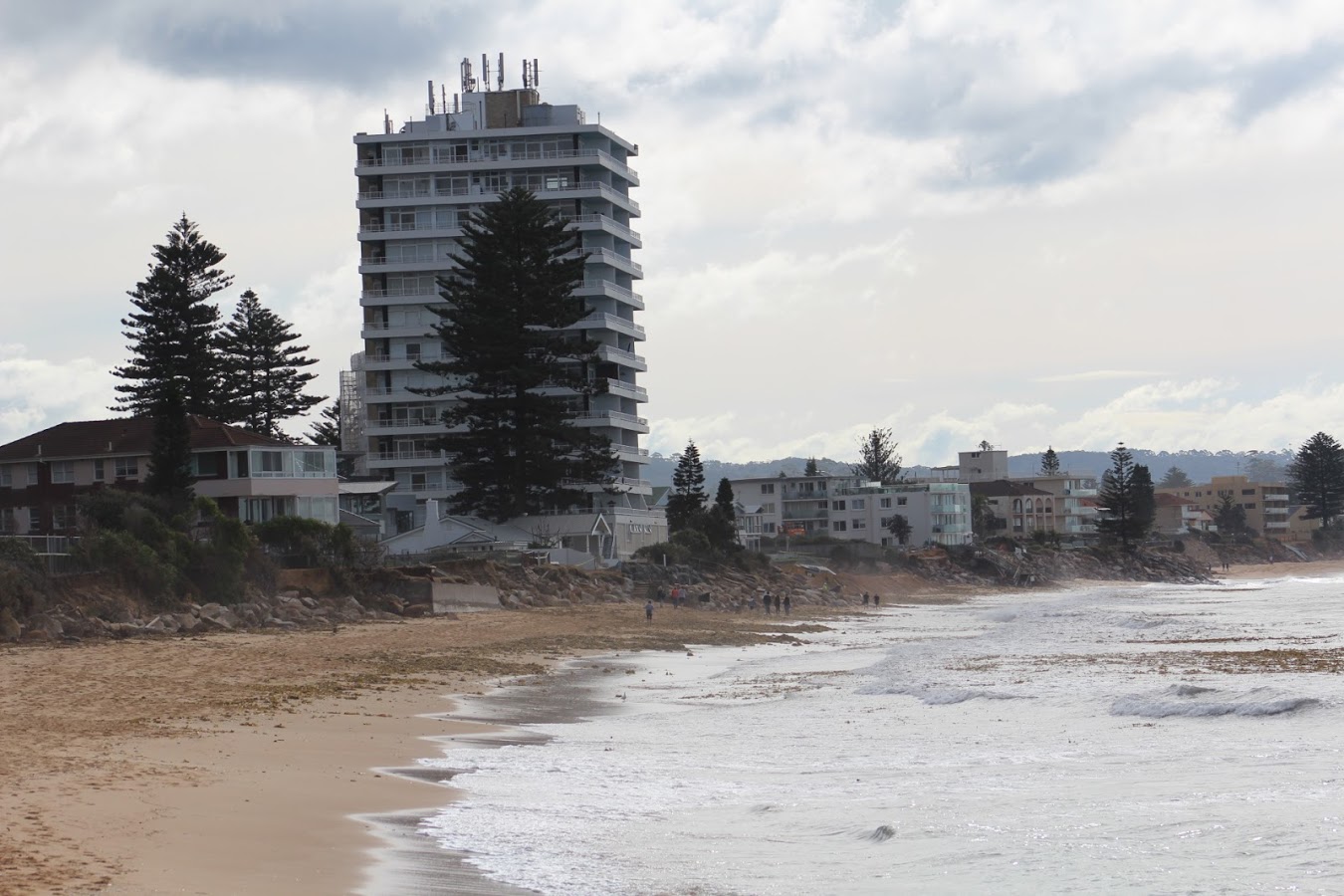
Damaged houses at Collaroy Beach, Sydney in the wake of an extreme storm in June 2016. UNSW Water Research Laboratory, Author provided
While extreme storms can cause major erosion to beachfront properties, they can also bring in new sand from deeper water. UNSW Water Research Laboratory, Author provided
Wave after wave
Violent storm waves strip beaches of sand above the waterline, which often erodes sand dunes. In deeper waters, however, these same waves help stir up sediment lying dormant on the seabed. This sand is then pushed towards the shore and settles as the storm passes.
To study the three storms in Australia, the UK and Mexico, we used high-resolution monitoring equipment including twin engine airplanes, drones and jet skis mounted with an echo-sounder for measuring the seabed.
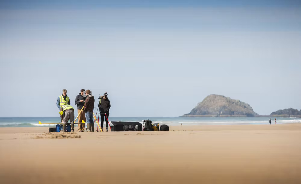
The UK survey team measuring sand volumes along the coast of Cornwall. University of Plymouth, Author provided
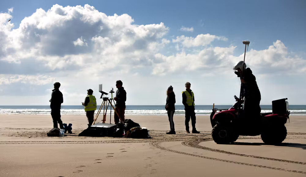
A combination of high-resolution survey equipment was used to measure changes to the beach. University of Plymouth, Author provided
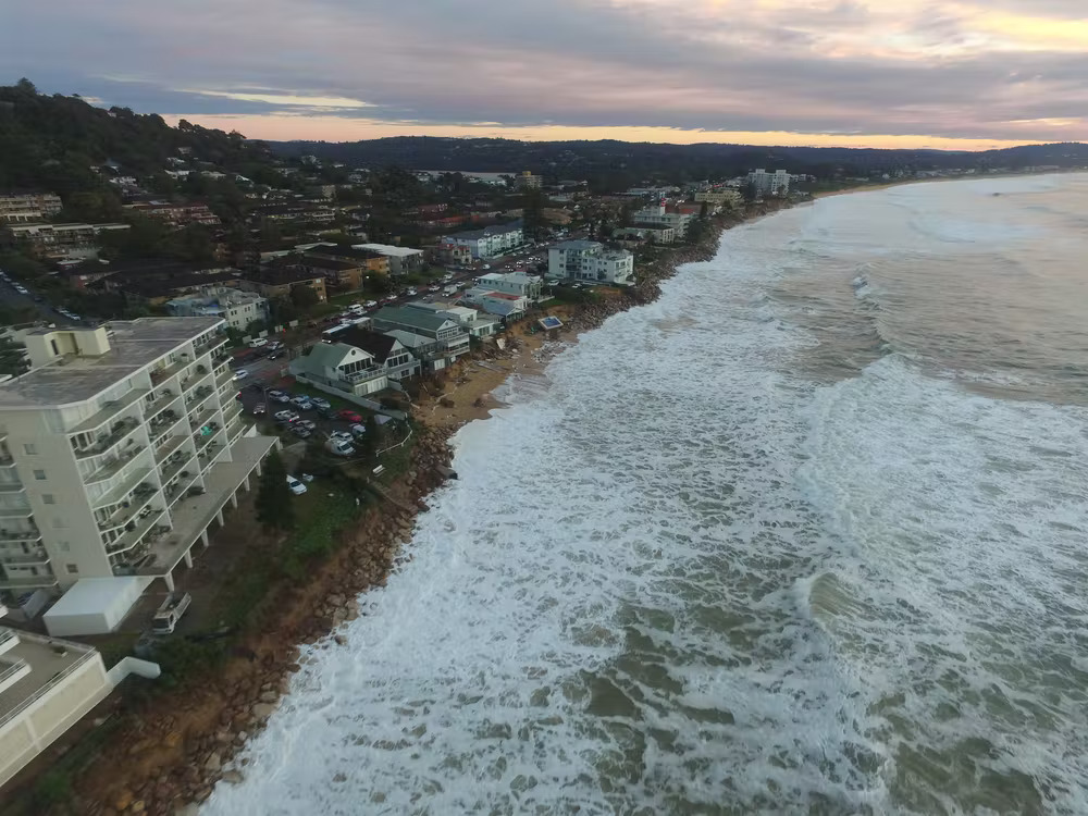
In Australia, we measured Narrabeen Beach in Sydney. In the UK, we monitored the impact of several storms during the winters of 2013-2014 and 2015-2016, at Perranporth beach in Cornwall. And in northwest Mexico, we recorded the impact of the 2018-2019 winter on La Mision Beach.
In the time-lapse video below, you can see just how quickly the water can encroach on beachfront houses during extreme storms. Beneath the water surface, however, huge volumes of sand is also moving about.
Source: UNSW Water Research Laboratory (author provided)
Rethinking coastal erosion
Exactly how a coastline might change due to sea-level rise is a key question facing coastal managers, as they plan for the escalating impacts of climate change.
The Intergovernmental Panel for Climate Change projects global sea levels to rise up to 76 centimetres by 2100, under a middle-of-the-road emissions scenario where global temperatures rise 2.1-3.5℃.
The response of the coast to sea-level rise has previously been estimated using an approach known as the Bruun rule. This rule states that for a given metre of sea-level rise, the coastline is expected to retreat between around 20m to over 100m, depending on the steepness of the coast.

UNSW researcher Chris Drummond launching a drone to survey the beach in Sydney. UNSW Research Laboratory, Author provided
Using the Bruun rule, global sea-level rise caused by climate change has been projected to result in losing almost half the world’s sandy beaches by 2100. However, not all coastal scientists share this view.
Let there be no doubt: sea-level rise is a tragic consequence of climate change, and it poses an existential threat to many coastal communities, especially for island nations in the Pacific.
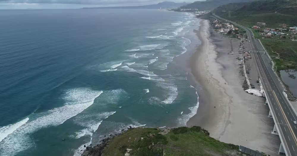
Mexico’s La Mision beach, on a calm day. In the winter of 2018-2019, research found that storms pushed 130,000 cubic metres of new sand into the beach system. Autonomous University of Baja California, Author provided
What our new research confirms is that the Bruun rule approach is overly simplistic, as it doesn’t take into account the many complex local factors about how individual beaches respond to sea-level rise.
This includes the amount of sand stored in deeper water immediately off the coast, and its potential to replenish beaches during extreme weather events.
Understanding how sand moves along the coast is critical for better coastal planning. UNSW Water Research Laboratory, Author provided
Improving predictions in an uncertain future
While this research has focused only on three extreme storm sequences, it shows that understanding how sediment moves along the coast is fundamental to planning for climate change impacts.
There are two ways we can significantly improve long-term predictions of coastal change in this uncertain future:
- upscaling efforts in mapping the seabed to learn how much sediment is presently stored in the deeper coastal waters
- increasing routine coastal monitoring of the entire nearshore system, from the sand dunes down to deeper waters. This is currently carried out by UK coastal observatories.
A greater understanding of sand movements off the coast, combined with computer modelling, can better forecast future shorelines. This will give coastal managers the information needed to make critical long-term planning decisions for communities.
Read more: Why some beaches, including in Queensland, are getting bigger despite rising sea levels
Read more: The seas are coming for us in Kiribati. Will Australia rehome us?
Extreme Storms Could Help Protect Beaches From Sea Level Rise New Study Finds
May 12, 2022
Images in the wake of violent coastal storms usually focus purely on the extensive damage caused to beaches, dunes, property, and surrounding infrastructure.
However, a new international study has shown that extreme weather events could help protect beaches from the impact of sea level rise -- by bringing in new sand from deeper waters or from nearby beaches.
The study, led by Dr Mitchell Harley from the UNSW Water Research Laboratory, is published today in Nature Communications Earth & Environment.
"We know that extreme storms cause major coastal erosion and damage to beachfront properties," Dr Harley says.
"For the first time we looked not just above water, where the impacts of extreme storms are easy to see, but also deep down below the water as well.
"What we found was that hundreds of thousands of cubic metres of sand was entering these beach systems during these events -- that's similar to the scale of what engineers use to nourish a beach artificially.
"This could potentially be enough to offset some of the impacts of sea level rises caused by climate change, such as retreating coastlines, and by several decades in the long-term.
"It's a new way of looking at extreme storms."
Wave after wave
In collaboration with researchers from University of Plymouth and Autonomous University of Baja California, the study examined three coastlines across Australia, the United Kingdom and Mexico. Each was subject to a sequence of extreme storms or extended storm clusters, followed by a milder period of beach recovery.
In Australia, researchers studied Narrabeen beach in Sydney in the wake of a 2016 storm which famously ripped a swimming pool away from a property overlooking the coastline.
Using high-resolution measurements of the beach and seabed, they were able to show that sediment gains were sufficient to theoretically offset decades of projected shoreline retreat.
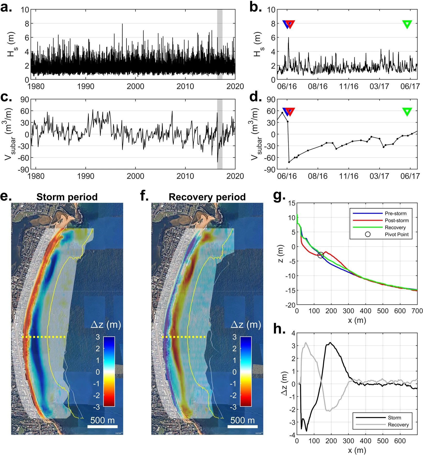
Fig. 3: Summary of wave and entire beach variability at Narrabeen Beach, Australia. a Deep-water significant wave height for Sydney (1979–2020); and b during the storm-recovery sequence. c Average subaerial volume change from long-term surveys (1979–2020); and d during the storm-recovery sequence. e Overall vertical change due to the storm period and f during the recovery period (Depth of Closure indicated by yellow solid lines). g A representative cross-shore transect indicating pre-storm, post-storm, and recovery morphology; and h the vertical change over these two periods. Shaded regions in panels a and c denote the storm-recovery sequence and triangles in b and d the timing of pre-storm (blue), post-storm (red), and recovery (green) surveys. Basemap data in (e, f) ©2022 Nearmap. From: Single extreme storm sequence can offset decades of shoreline retreat projected to result from sea-level rise
"For the first time, we were able to mobilise specialised monitoring equipment to get really accurate measurements before and after a storm," Dr Harley says.
"We used a combination of a twin engine aeroplane equipped with a Lidar scanner, drones and jet skis going back and forth along the beach taking measurements below the surface right before and after the storm hit.
"This was how we were able to get an accurate picture of the volume of sand moving for each storm."
In the UK, researchers of the Coastal Processes Research Group of the University of Plymouth have studied Perranporth beach in Cornwall since 2006 using a combination of monthly beach topographic surveys and quasi-annual bathymetric surveys.
Here, the impact of the extreme 2013/14 and 2015/16 winters resulted in very significant losses of sand from the intertidal beach and dune system. However, when looking at the total sand budget, including the underwater part of the beach, it was observed that by 2018 the beach had gained 420,000 cubic metres of sand.
"We are not quite sure whether this extra sand has come from offshore or from around the corner, or even both, but we do now understand that extreme waves can potentially contribute positively to the overall sand budget, despite causing upper beach and dune erosion," said Professor Gerd Masselink, who leads the Coastal Processes Research Group.
Bruun rule
Exactly how much a coastline might change due to sea level rise is a key question facing coastal managers as they plan for the escalating impacts of climate change.
In the past, this has been estimated using a simple approach known as the Bruun rule. This rule states that for a given metre of sea-level rise, the coastline is expected to retreat between roughly 20 and 100 metres, depending on the steepness of the coast.
Using the Bruun rule, global sea-level rise caused by climate change has been projected to result in a large retreat or loss of almost half of the world's sandy beaches by the end of this century.
"The Bruun rule however has been criticised for its simplicity, as it doesn't take into account the many complex factors about how individual beaches respond to sea-level rise," Prof. Masselink says.
"This includes the presence of sand stored in deeper water immediately off the coast -- and its potential to be mobilised during extreme weather events."
Dr Harley says these findings highlight that extreme storms need to be considered in long-term projections of sediment movements on beaches.
"It further reinforces that we really need to be doing a beach-by-beach understanding of how our beaches are going to change as global sea-level rise continues."
Looking past the eye of the storm
Dr Harley says there are so few measurements of the seabed immediately off our coastlines that it's hard to tell how much sand could potentially be mobilised in the future.
While these findings are from only three extreme storm sequences, it potentially changes how people can understand the long-term future of our coastlines.
"We're only scraping the surface here. We need to repeat these types of monitoring measurements for more storms and different types of coastal settings under various conditions," he says.
"Only then, will we be able to get a clearer understanding of how much sand is stored off the coast that could potentially help buffer the impacts of sea level rise -- and a clearer picture of what our beaches could look like in the year 2100 and beyond."
Mitchell D. Harley, Gerd Masselink, Amaia Ruiz de Alegría-Arzaburu, Nieves G. Valiente, Tim Scott. Single extreme storm sequence can offset decades of shoreline retreat projected to result from sea-level rise. Communications Earth & Environment, 2022; 3 (1) DOI: 10.1038/s43247-022-00437-2
The data that support the findings of this study are available for download at https://doi.org/10.5281/zenodo.5748645. Narrabeen-Collaroy survey program data is available at http://narrabeen.wrl.unsw.edu.au/.