Community Group 'Save the Northern Beaches Bushland' was formed to stand up for the long-term preservation and protection of northern beaches bushland areas, places that are habitat for wildlife, flora, and endangered ecological communities.
Save the Northern Beaches Bushlands Facebook page.
In August 2022 a Development Delivery Plan (DDP) for 6 sites owned by the Metropolitan LALC in the Northern Beaches LGA was approved by the NSW Department of Planning. This is bushland located at Lizard Rock (Morgan Road), Aquatic Drive, Forest Way, Corymbia Circuit, Paxton St, and Ralston Ave. The sites are spread across the suburbs of Belrose, Davidson, Frenchs Forest, Oxford Falls and Allambie Heights.
The DDP responds to the Aboriginal Land Rights Act 1983, which established Aboriginal land councils to manage land to provide an economic base for Aboriginal communities as compensation for historic dispossession and ongoing disadvantage.
The Department of Planning confirmed in 2022 of the nine sites (totalling 912 ha) owned by the MLALC across the Northern Beaches LGA, only the 71ha Lizard Rock site has been endorsed by MLALC members and the NSW ALC to be actively investigated for land dealing. The Morgan Road proposal was identified as the short term priority as it has the most potential for development. The MLALC wants this land rezoned to deliver up to 450 dwellings on 71 hectares of bushland and hundreds of millions to support their programs for their members, just as any other development company.
The remaining 5 sites could have planning proposals or DAs submitted over the next 5 years.
The Planning Department has stated; 'We may expand the Northern Beaches Development Delivery Plan (DDP) if additional sites are investigated to ensure any planning proposals are consistent with its objectives.'
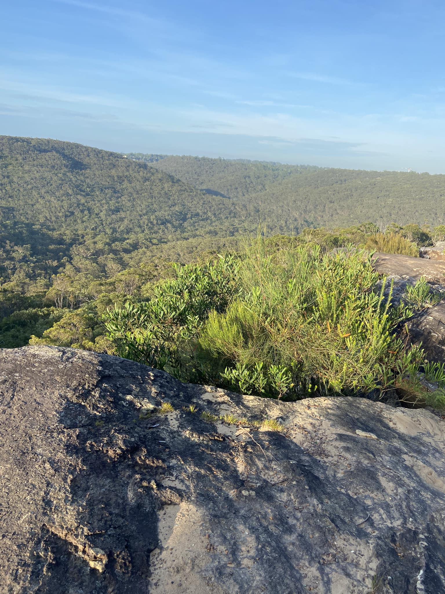
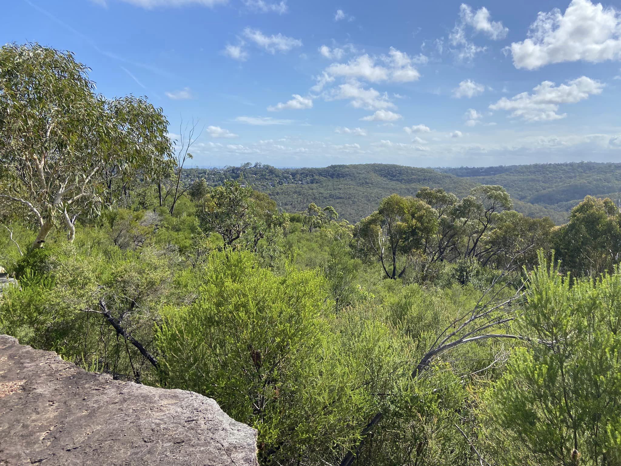
These sites are habitat for native flora and fauna, including endangered species. They also contain Aboriginal culturally significant sites and creeks that flow into Narrabeen Lagoon catchment.
The Save the Northern Beaches Bushland group brings together people who have concerns about the planning proposal from the Metropolitan LALC for a site on Morgan Road, Belrose, along with other sites across the area.
The Metropolitan LALC has renamed their planning proposal, formally known as Lizard Rock, to the Patyegarang Planning Proposal. The decision to rename the planning proposal was made, the Department of Planning stated, to better reflect the cultural significance of the site to the Aboriginal community.
Patyegarang, a Gamaraigal girl, is remembered because she taught her language to First Fleet naval officer Lieutenant William Dawes and he made an extensive record of these words - with numerous references to fish hooks and fish. The Cammeraygal, variously spelled as Cam-mer-ray-gal, Gamaraigal, Kameraigal, Cameragal and several other variations, are one clan of the 29 Darug tribes who survived as skilled hunter–fisher–gatherers in family groups that inhabited the Lower North Shore of Sydney. There is no record of her standing in what is today called the electorate of Davidson and on hills from which you can see and smell the sea air of Pittwater.
The 'Save the Northern Beaches Bushland' group states:
''We are not opposed to needed development in the northern beaches, and are very much in support of Aboriginal self-determination, but not at the cost of our last precious natural bushland areas.''
The Save the Northern Beaches Bushland includes northern beaches and adjacent area First Nations members who state they are opposed to the development. Some of their concerns relate to as yet unmapped sacred sites on the land holdings while others have wanted a return to 'singing up of country', which in essence precludes destruction of bushland areas.
''As an Aboriginal woman birthed on the North Shore l say thank you for trying so hard to protect our creation. Power to the People.''
Group members are also calling for a change in the culture in Department of Planning and the Decisions made in the NSW Land and Environment Court, where an ever-evolving state government housing and planning policy overrules council LEPs and DCPs.
''The current model is just ongoing destruction of bushland and doesn't take on board new ways of thinking and improving design and building, they continue with the old models.'' one member of the group states
The group has been one of several at the core of two rounds of 'consultation' on the Patyegarang (Lizard Rock) Planning Proposal, with over 1100 community individual and groups responses to the first round in 2022 and over 3700 in the second round, which closed on November 7 2023.
Biodiversity and threatened species was raised in 76% of those first round responses as of primary concern.
The Dept. of Planning's response to this was:
The SEPP amendment and Northern Beaches DDP establish a framework to investigate potential development and conservation outcomes within the six sites.
As part of these investigations, detailed studies including biodiversity impact assessments and ecological assessments, would need to be undertaken to consider the effect of any proposed development on threatened species, endangered ecological communities, and their habitats.
These studies would also inform potential development areas and identify areas with conservation values to be protected.
High level constraints mapping indicates the sites contain threatened species, high value vegetation and ecologically significant areas. Detailed studies, including ground truthing of this constraints mapping, would be required to confirm each sites biodiversity values and the legislative assessment requirements that would need to be addressed in any future development proposals.
Any future planning proposals or development applications would be subject to the same environmental assessment and legislative requirements as any other proposal at the planning proposal or development application stage.
Which reflects group members recognition that the Dept. of Planning has been structured to be a:
''model is just ongoing destruction''
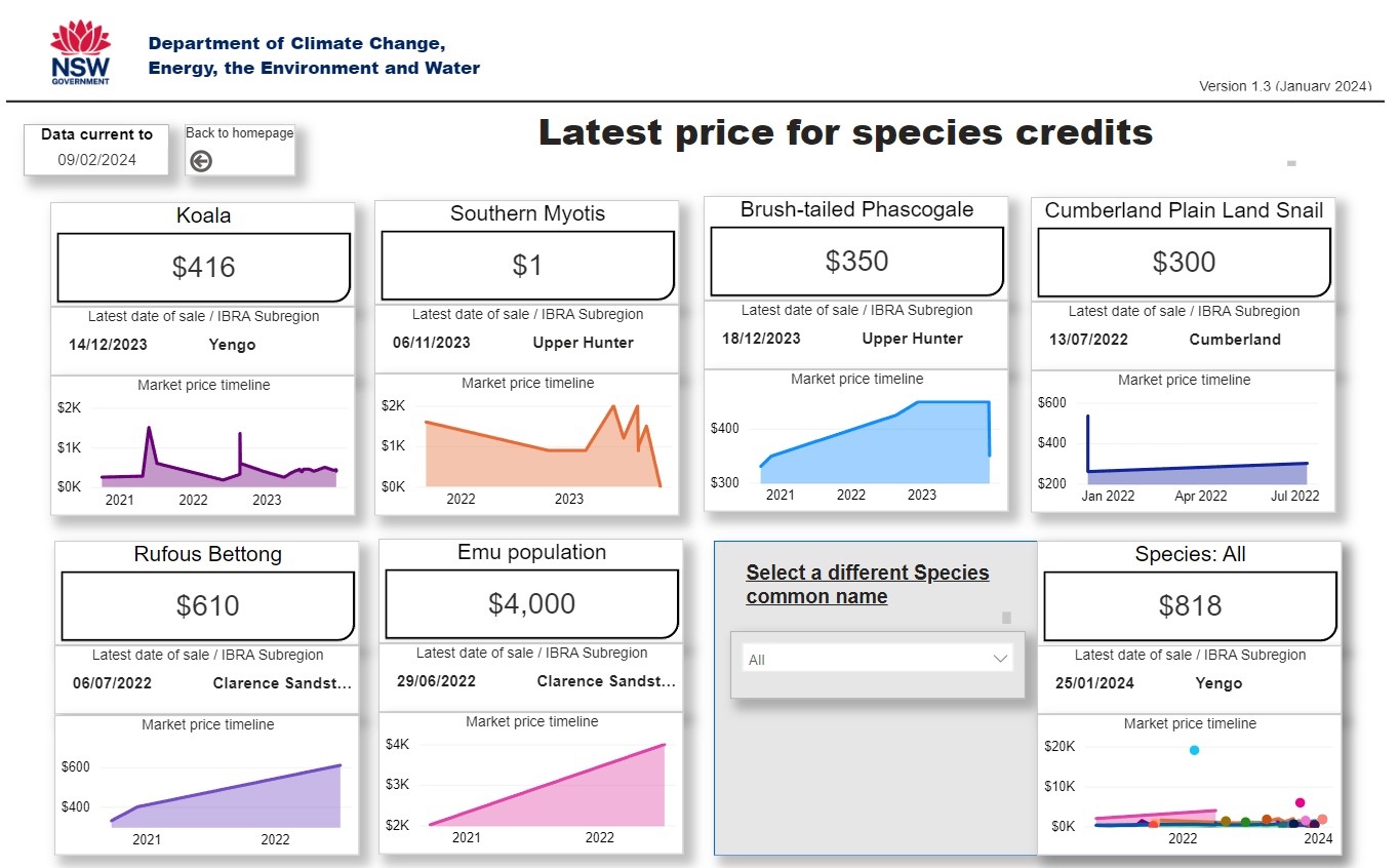
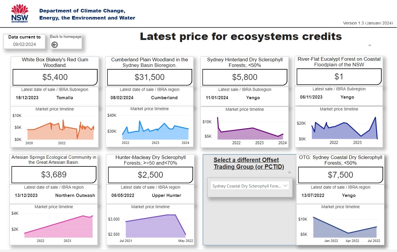
The second round of 'consultation' presented a Biodiversity report. The need for 'offsets' was included listing:
'Eastern Pygmy-possum Cercartetus nanus. Loss of habitat (ha) or individuals: 44.68 ha. Number of species credits required: 1211'
"It is noted that the off-set requirement could be met by total payment of $8,850,139.39 into the Biodiversity Conservation Fund in accordance with the NSW Biodiversity Offsets Scheme."
Biodiversity offsets are defined as conservation activities intended to compensate for the lasting impacts of development on species and ecosystems that persist even after other mitigation measures. Offsets are built around the idea of “no net loss”; an assumption that damage to ecosystems and destruction of the same by development projects can be balanced or outweighed by “producing” or preserving nature elsewhere.
The offset rules permit proponents to meet their offset obligation by:
- retiring credits based on the like-for-like rules, or
- funding a biodiversity conservation action that benefits the threatened entity impacted by the development. The action must be listed in the Ancillary rules: Biodiversity conservation actions and meet the other requirements set out by these rules, or
- committing to deliver mine site ecological rehabilitation that creates the same ecological community or threatened species habitat (available for major mining projects only). The ecological rehabilitation must meet the requirements set out in the `ancillary rules for mine site ecological rehabilitation' which will be published by the Environment Agency Head, or
- making a payment to the Biodiversity Conservation Fund calculated using the offsets payments calculator.
If a proponent can demonstrate they were not able to find like-for-like credits and chooses not to use the other offset options, they can seek approval to offset with a broader suite of biodiversity using the variation rules.
The Cumberland Plain Woodland, listed above, is one of six main indigenous woodland communities of Sydney. Currently, less than 6% of the Woodlands remain in small parts distributed across the western suburbs of Sydney, totalling only around 6400 hectares. Cumberland Plain Woodland was listed as an Endangered Ecological Community under the Threatened Species Conservation Act 1995 in June 1997.
The Southern Myotis, listed as Vulnerable in NSW, which can be had for $1, even with another NSW recommending that in order for this species to survive to; Retain native vegetation along streams and rivers and around other waterbodies; Minimise the use of pesticides adjacent to foraging areas; Protect roosts from damage or disturbance.
Species such as brushtail possums aren't listed. They either aren't counted or don't count. They, alike endangered ecological communities of which there isn't enough left to establish a 'like for like' may be offsetted into extinction as:
''The current model is just ongoing destruction...''
Formally, this past week, Nicole Romain, a founder of the group, along with Bruce Shillingsworth, a Budjiti/Murrawari man, have written to every related Local, State Member and Federal Minister, including the Prime Minister, rebutting what is being put forward.
They have requested a response within 21 days.
''This is being called to a halt for a good reason with a large number of sacred sites in all these areas and sites we do not know about.''
''There was previously a Gai-Mariagal National Park proposal for an Aboriginal owned National Park put forward for this whole area in 2013 by the Metropolitan Local Aboriginal Land Council and we are asking for this to be put in place again as originally proposed.''
In 2014 community forums at both Mona Vale and Narrabeen discussed the Gai-Mariagal National Park proposal. On May 12th 2014 at Mona Vale Memorial Hall the ASGMWP's Guest speaker was Kathy Ridge from the Aboriginal Land Council, who outlined the future and plans for the Gai-mariagal Aboriginal Owned National Park.
On Monday November 24th Friends of Narrabeen Lagoon Catchment hosted Nathan Moran, CEO of the MLALC as their Guest Speaker, who spoke about Waratah Park and Gai-mariagal National Park. Waratah Park, where Skippy the Bush Kangaroo was filmed, was handed to the MLALC in August 2014 where the MLALC hoped to use the site as an Aboriginal cultural and heritage centre.
CEO of the MLALC Nathan Moran explained at a 2019 Wingara forum; ''We operate with $148,000 dollars of guaranteed funding to service sixteen thousand Aboriginal people, to look after four and a half thousand culture and heritage sites, to provide community benefits of funeral assistance, sponsorship, social housing and provide events. It's about eight cents a blackfella we worked it out one time.''
Again, the DDP responds to the Aboriginal Land Rights Act 1983, which established Aboriginal land councils to manage land to provide an economic base for Aboriginal communities as compensation for historic dispossession.
With Patyegarang now called in, and with the Save Northern Beaches Bushlands group avowed to keep raising awareness for change, something brilliant could resolve what has become a contentious issue between local indigenous peoples and those who claim authority over them, as well as a community divided by loss of bushland but still against going up instead of out in housing and a Planning Department whose
''current model is ... ongoing destruction...''
During the second exhibition period, the Department of received over 3,700 submissions from the community and stakeholders. Key matters raised in submissions included, once again:
- loss of bushland
- impacts (deaths of) on significant flora and fauna
- bushfire risk and evacuation
- infrastructure to support new residents
- traffic and access
- waterway impacts
- the scale of the proposed rezoning.
All feedback is being reviewed before a report is prepared for the Sydney North Strategic Planning Panel. By Mid 2024 the panel will provide a recommendation to the Department of Planning on whether the proposal should be finalised and if so in what form. The Minister, or the Department as the Minister’s delegate, will make the final determination for the planning proposal via the
''current model for ... ongoing destruction...''
''To support a better outcome that could stop this destruction through finding a better solution you can also write to the Minister for Planning and Public Spaces, Paul Scully including Minister for Climate Change, Energy, the Environment and Heritage, Penny Sharpe.'' Ms Romain and Mr. Shillingsworth have said in a statement
''To keep updated you can join Save the Northern Beaches Bushlands Facebook.''