Local Sites: From Part 2
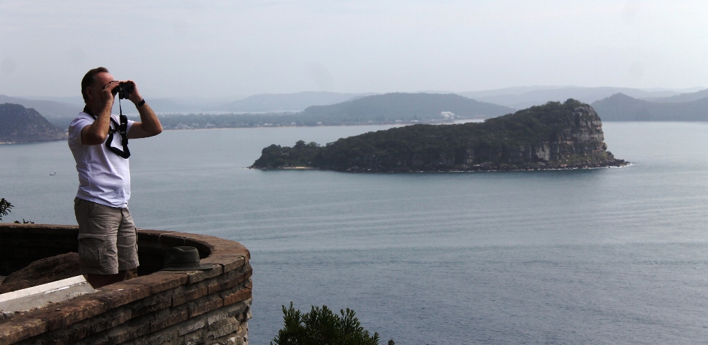
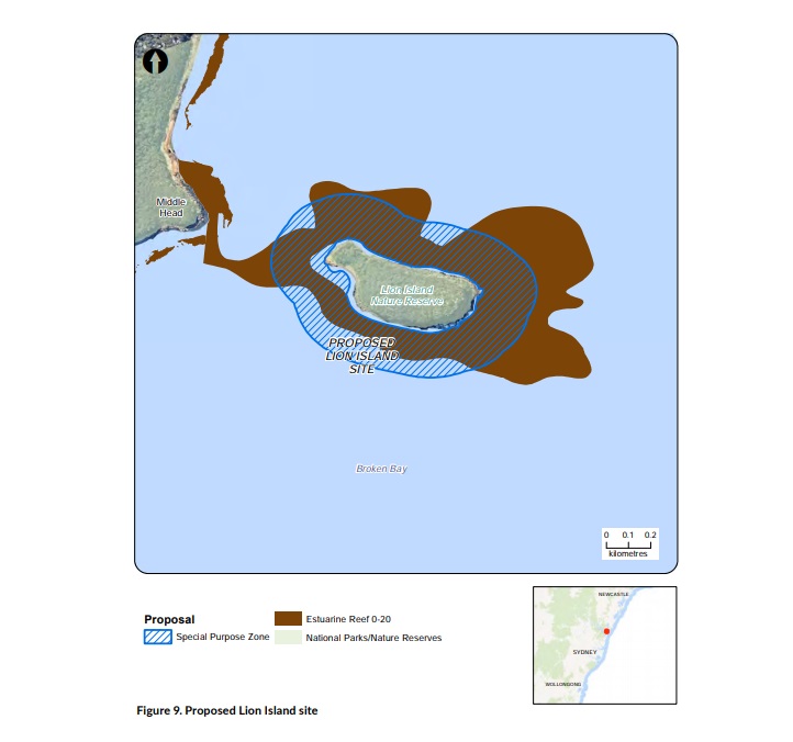
LION ISLAND
Lion Island is located in Broken Bay. A special purpose zone is proposed covering a 45 hectare area within 200 metres of the Island (Figure 9).
CURRENT MANAGEMENT
Lion Island was dedicated as a fauna reserve in 1956 and reclassified as a nature reserve under the National Parks and Wildlife Act 1974. No specific spatial management arrangements are in place other than existing regulations that generally apply to activities in the marine estate, such as NSW fishing rules and restrictions.
SITE OBJECTIVES
The primary objective for the proposed Lion Island site is to:
• reduce risks to identified threatened and protected species of the bioregion.
The secondary objectives that apply to this site are listed in Table 5.
ENVIRONMENTAL, SOCIAL, CULTURAL AND ECONOMIC VALUES
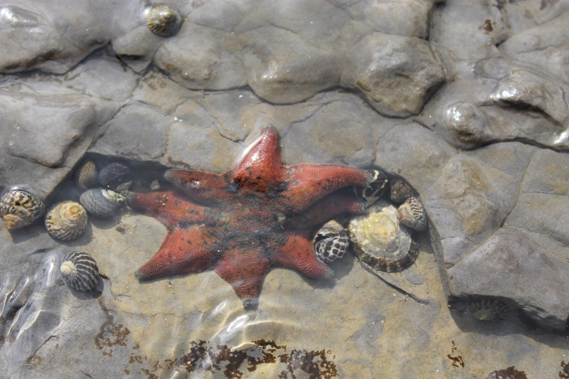
The waters surrounding Lion Island are important for the little penguin (Eudyptula minor), which is listed as a threatened species under the Biodiversity Conservation Act 2016.
The area has significance to the local Aboriginal communities. Spiritual sites and evidence of past cultural use, including shell middens, have been recorded.
PRIORITY THREATS TARGETED TO ENHANCE BENEFITS AT THIS SITE
The threats that will be addressed at this site and expected benefits to be enhanced are listed in Table 19.
PROPOSED MANAGEMENT RULES
Vessel speed restrictions (8 knots) are proposed in all waters within 200 metres of Lion Island to reduce the chance of vessel strike to little penguins. Hand gathering and collecting marine vegetation would be prohibited (Table 20).
FEEDBACK FROM COMMUNITY ENGAGEMENT
Lion Island was identified as having conservation value during community engagement. The National Parks Association of NSW (Southern Sydney Branch) described this site as having high biodiversity value.
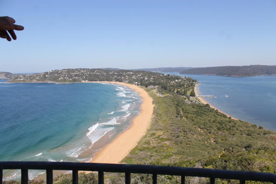
BARRENJOEY HEAD
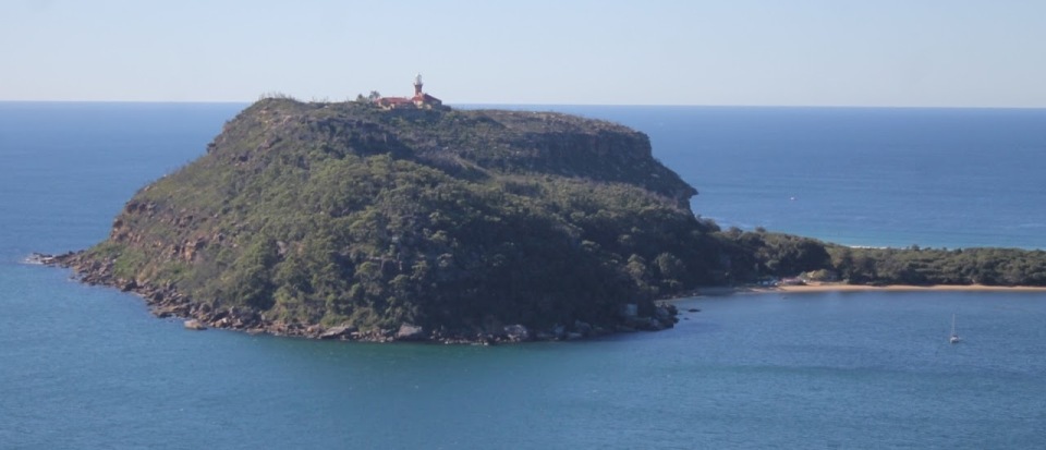
Barrenjoey Head is located at the northern end of the Palm Beach isthmus. The iconic Headland is part of a national park, has an historic lighthouse and is the southern head of Broken Bay, at the entrance to Pittwater.
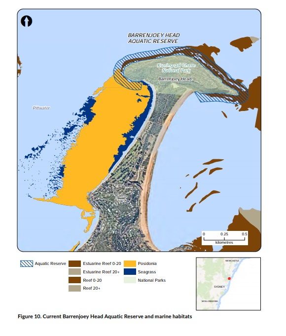
The proposed special purpose zone would extend the current Barrenjoey Head Aquatic Reserve (Figure 10) to cover a total area of 133 hectares and include the adjacent seagrass, including the endangered population of Posidonia australis (Figure 11).
CURRENT MANAGEMENT
The existing Barrenjoey Head Aquatic Reserve was established in March 2002. The reserve covers 28 hectares, extending around the headland and including the area between the mean high water mark and out to 100 metres offshore from the mean low water mark.
Collecting cunjevoi, invertebrates and marine vegetation is prohibited, with the exception of rock lobsters, abalone, sea lettuce and bait weed. Recreational fishing competitions and collecting for scientific and educational purposes require a permit.
A fishing closure under the Fisheries Management Act 1994 prohibits netting by recreational and commercial fishers from Barrenjoey Head to Stokes Point; the aim is to limit the potential spread of marine algae, Caulerpa taxifolia.
SITE OBJECTIVES
The primary objectives for the proposed Barrenjoey
Head site are to:
• reduce risks to identified threatened and protected species of the bioregion
• reduce risks to identified habitats of the bioregion
• continue to provide for marine economic opportunities that are consistent with ecologically sustainable development, for example low-risk commercial fishing activities
• establish and maintain public infrastructure to support access and use of the bioregion, for example moorings, boat ramps.
The secondary objectives that apply to this site are listed in Table 5.
ENVIRONMENTAL, SOCIAL, CULTURAL AND ECONOMIC VALUES
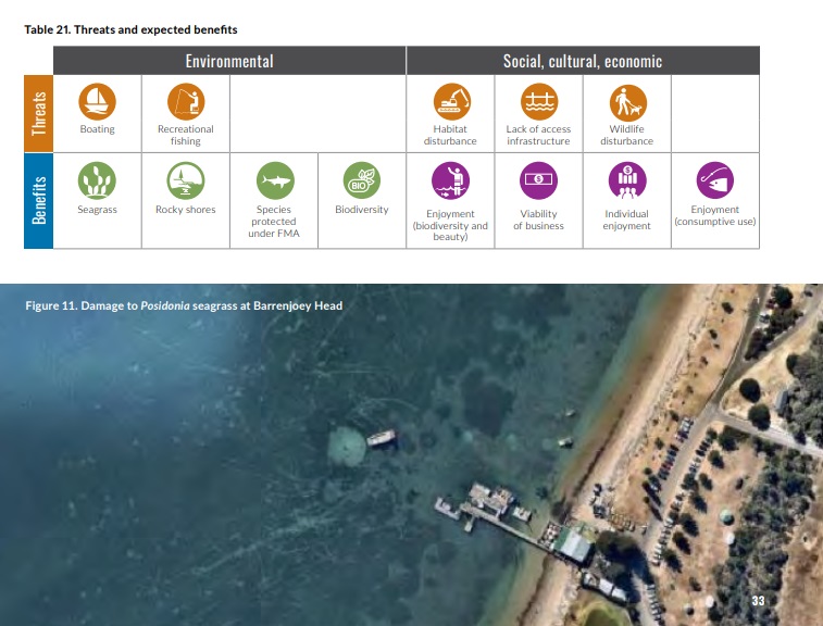
The existing aquatic reserve contains a variety of habitats. The combination of estuarine and oceanic influences supports the wide variety of marine life found here. The northern facing shoreline contains a relatively steep intertidal area dominated by large boulders, and a narrow strip of subtidal reef dominated by turf algae and some kelp. There are extensive seagrass beds located adjacent to the western side of the isthmus, including a large area of an endangered population of seagrass, Posidonia australis, which is listed under the Fisheries Management Act 1994. Significant damage to seagrass from anchoring, propellers, and swing moorings is evident from aerial imagery (Figure 11).
Barrenjoey Headland and its surrounding waters are frequented by many user groups. Passive recreation (walking, swimming, kayaking, paddle boarding) is popular here. Boats frequently shelter in the Pittwater side of the headland. Surfing is popular on the ocean side at the northern end of Palm Beach. Barrenjoey Headland is also used by recreational line fishers and spearfishers.
The area has significance to the local Aboriginal communities. Spiritual sites and evidence of past cultural use, such as shell middens, have been recorded in the Aboriginal Heritage Information Management System.
Some Ocean Trap and Line commercial fishing takes place in the area.
PRIORITY THREATS TARGETED TO ENHANCE BENEFITS AT THIS SITE
The threats that will be addressed at this site and expected benefits to be enhanced are listed in Table 21.
PROPOSED MANAGEMENT RULES
Fishing rules that apply to the existing aquatic reserve would be adopted in the proposed special purpose zone (Table 22).
Boating and moorings at the site would be reviewed and restrictions developed with boating stakeholders to reduce damage to seagrass from propellers and moorings. Anchoring in seagrass would not be permitted.
Aboriginal cultural use and recreational activities, such as swimming, snorkelling and scuba diving, would continue to be permitted.
FEEDBACK FROM COMMUNITY ENGAGEMENT
The conservation value of Barrenjoey Head was identified by community members and peak conservation stakeholders – the National Parks Association of NSW and Nature Conservation Council of NSW. Concerns regarding the establishment of a no take area at this site were raised by recreational fishers and spearfishers as it is reported to be a safe area to spearfish and fish from small vessels.
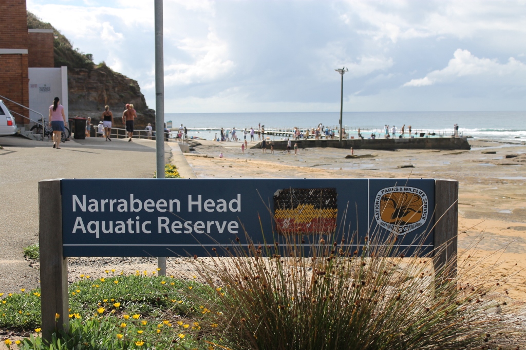
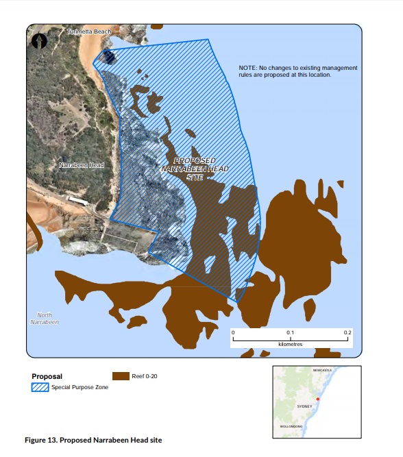
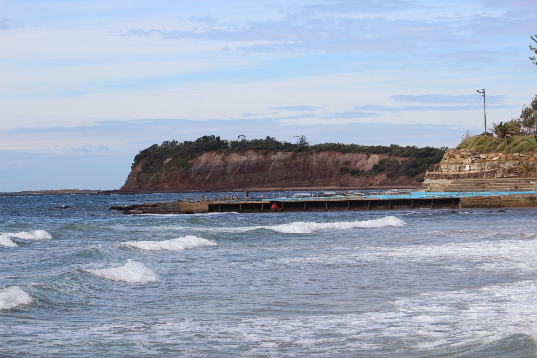
NARRABEEN HEAD
The site is located at North Narrabeen Headland on Sydney’s northern beaches. It is proposed to establish a special purpose zone to replace the existing aquatic reserve. No changes to management rules are proposed.
CURRENT MANAGEMENT
Narrabeen Head Aquatic Reserve was established in March 2002. It covers seven hectares and extends from the southern end of Turimetta Beach, to the western extremity of the rock baths at Narrabeen Head, covering the area from the mean high water mark to a distance of 100 metres offshore of the mean low water mark.
Collection of cunjevoi, marine invertebrates and seaweed is prohibited in the reserve, with the exception of lobster, abalone, sea lettuce and bait weed. Recreational fishing competitions and collecting for scientific and educational purposes require a permit.
SITE OBJECTIVES
The primary objectives for the proposed Narrabeen Head site are to:
• enhance opportunities for scientific research, education and learning including Aboriginal culture
• promote stewardship of the marine estate.
The secondary objectives that apply to this site are listed in Table 5.
ENVIRONMENTAL, SOCIAL, CULTURAL AND ECONOMIC VALUES
The site primarily consists of rocky shore, shallow rocky reef, beach and shallow soft sediments. It contains a diverse array of marine algae, invertebrates and fishes.
Birds such as oystercatchers, cormorants, sea gulls and sea eagles also forage in the area.
Narrabeen Head Aquatic Reserve was declared primarily to facilitate educational activities on the rocky shore. As such, it is highly valued for education and regularly used as a marine field study site by school groups. The Coastal Environment Centre at Narrabeen, run by Council, conducts environmental education activities in the local area as do private education companies Ecotreasures
and AUSECO.
The reserve is currently used for a wide variety of recreational activities, including snorkelling, scuba diving, swimming, sunbathing, picnics, recreational boating, line and spear fishing, walking and dog walking.
The site is located adjacent to the North Narrabeen National Surfing Reserve.
PRIORITY THREATS TARGETED TO ENHANCE BENEFITS AT THIS SITE
The threats that will be addressed at this site and expected benefits to be enhanced are listed in Table 23.
PROPOSED MANAGEMENT RULES
The proposed seven hectare special purpose zone (Figure 13) would maintain the existing boundaries and current fishing rules, with continued access to the reserve as an educational area and for Aboriginal cultural use. The assessment found that there were limited opportunities for further threat reduction at the site as it has limited subtidal environmental assets. There is also little opportunity for further enhancing social and cultural benefits.
FEEDBACK FROM COMMUNITY ENGAGEMENT
The high environmental value of Narrabeen Head was identified by peak conservation stakeholders – the National Parks Association of NSW and the Nature Conservation Council of NSW.
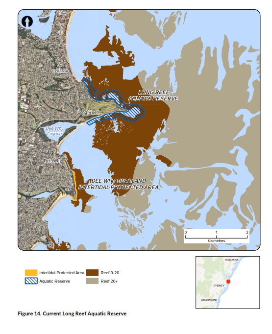
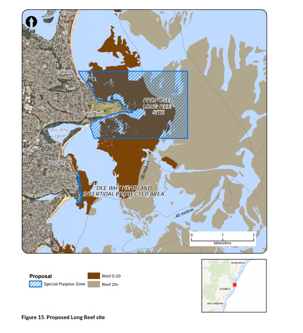
LONG REEF
Long Reef is a prominent beach, headland and rock platform on Sydney’s northern beaches, between Collaroy and Dee Why.
The proposed special purpose zone would expand the existing Long Reef Aquatic Reserve to include the adjacent subtidal reef. It is proposed to establish this zone as a site managed for sustainable recreational fishing.
CURRENT MANAGEMENT
The existing Long Reef Aquatic Reserve (Figure 14) was established in 1980 and is the oldest aquatic reserve in NSW. It covers 77 hectares, extending from Collaroy Rock Baths to Long Reef Surf Lifesaving Club and seaward from the mean high water mark to a distance of 100 metres offshore of the mean low water mark.
Collecting, destroying or interfering with cunjevoi, invertebrates and marine vegetation is prohibited. Finfish may be taken by spear or line. Collecting for scientific and educational purposes require a permit.
SITE OBJECTIVES
The primary objectives for the proposed Long Reef site are to:
• promote marine ecotourism in the bioregion
• enhance bequest values for current and future generations
• provide enhanced recreational experiences for particular user groups
• enhance opportunities for scientific research, education and learning including Aboriginal culture
• ensure appropriate mechanisms exist for community involvement in the management of the marine estate
• promote stewardship of the marine estate.
The secondary objectives that apply to this site are listed in Table 5.
ENVIRONMENTAL, SOCIAL, CULTURAL AND ECONOMIC VALUES
The site consists of a rock platform that projects from the coastline and provides rocky shore and shallow reef habitat with a full range of wave exposure and aspect. The reef platforms and reef complex extending across the shelf are together one of the best examples
of a wide range of interconnected ree
f habitats in the bioregion. The reefs include caves and overhangs and deep gutters.
Long Reef is dominated by extensive intertidal, shallow and deep rocky reefs that extend as continuous habitats several kilometres offshore. The Long Reef rocky shore is uncommon in that it extends in all compass directions and incorporates a wide range of exposed and sheltered habitats: it is one of the most extensive intertidal rock platforms in NSW. A range of threatened and protected
species utilise habitats at this site and adjacent areas, including black rockcod (Epinephelus daemelii), weedy seadragon (Phyllopteryx taeniolatus), greynurse shark, and many species of seabirds and local and migratory wader birds.
Long Reef Headland is popular with many user groups for recreation (walking, swimming, kayaking, paddle boarding) and boating. It is recognised as one of the most iconic fishing locations in the region.
Commercial fishers regularly fish in the waters offshore from Long Reef.
The Long Reef rock platform is a focal point for marine education and stewardship programs, with school excursions and community groups regularly visiting the reserve to learn about marine life.
PRIORITY THREATS TARGETED TO ENHANCE BENEFITS AT THIS SITE
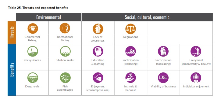
The threats that will be addressed at this site and expected benefits to be enhanced are listed in Table 25.
PROPOSED MANAGEMENT RULES
A 514 hectare special purpose zone is proposed at Long Reef. This would incorporate the current aquatic reserve and extend the current rules of the reserve, which permit line or spearfishing for finfish (fish with a backbone) only, and prohibit the collection of all marine invertebrates and plants whether dead or alive except for Aboriginal cultural use.
Other management methods that address the threats caused by recreational fishing are to be trialled at this site in consultation with recreational fishers.
Examples include catch-and-release fishing, gear-based restrictions, and specific bag and size limits. More information about the trial is described below.
FEEDBACK FROM COMMUNITY ENGAGEMENT
Long Reef was identified in Phase 1 and 2 community engagement. It was described as a site with high environmental values, in particular by peak conservation stakeholders – the National Parks Association of NSW and Nature Conservation Council of NSW. A
local, community-based campaign resulted in many submissions in support of a no-take area at Long Reef. Many submissions also raised concerns about a potential no-take area at this site, describing it as one of the safer rock platforms to fish from in NSW. Long Reef is reported to provide easy access for elderly fishers and has the only open ocean boat ramp on the northern beaches of Sydney.
The Recreational Fishing Alliance, as well as a number of other submissions, listed Long Reef as a site of great importance for spearfishers, especially in adverse weather. Several submissions also raised concerns about possible negative impacts on kayak based fishing at Long Reef.
ALTERNATIVE APPROACHES TO ADDRESSING THREATS FROM RECREATIONAL FISHING – LONG REEF TRIAL SITE
Peak stakeholders from the recreational fishing sectors have recommended to the NSW Government that alternative approaches be considered to address priority threats caused by recreational fishing as part of any proposal to expand marine protected areas in the Hawkesbury bioregion. These include:
- catch-and-release fishing – where any fish caught are released alive and fish are caught in accordance with recommended catch-and-release fishing gear and fish handling guidelines promoted by Department of Primary Industries Fisheries
- reviewing recreational fishing bag and size limits in the bioregion to allow some take of fish and other recreationally caught species
- promoting the use of low-impact fishing gear (such as lures, trolling, circle hooks) to target pelagic fish, rather than bottom-set gear to target demersal fish that are associated with particular habitat sites (such as rocky reefs) and may be subject to higher rates of fishing pressure in high-use fishing areas
- seasonal restrictions to reduce impacts on certain species when they are known to be more readily accessible in an area of the bioregion.
Long Reef on Sydney’s northern beaches has been chosen as a site to trial these alternative approaches. The trial will involve additional engagement with recreational fishers to determine the methods to be trialled and ways to monitor their effectiveness over time as part of the Marine Integrated Monitoring Program (MIM Program). Subject to the research outcomes, consideration will be given to expanding the measures to other sites.
CABBAGE TREE BAY
The proposed Cabbage Tree Bay site is south of Manly Beach. It is dominated by rocky shores and subtidal reefs. Shelly Beach, at the eastern end of Cabbage Tree Bay, is a key feature of the area.
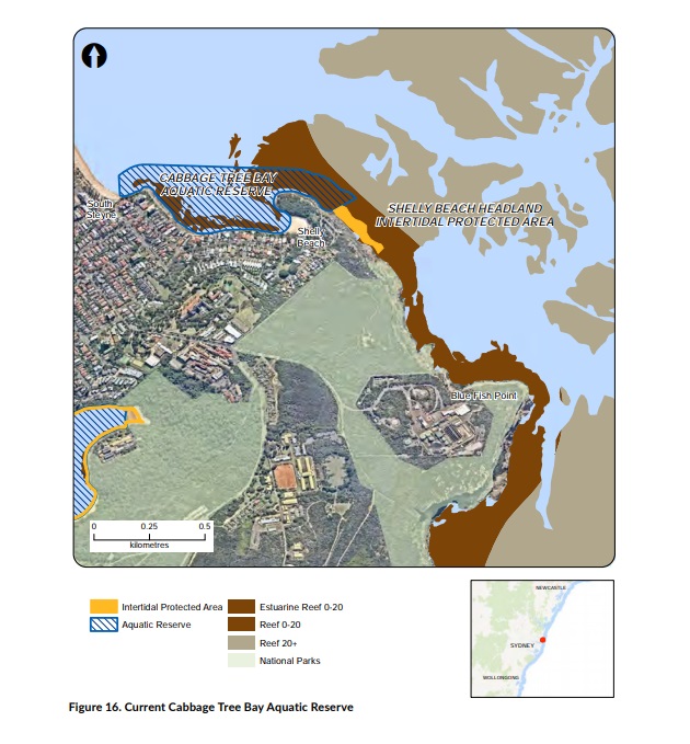
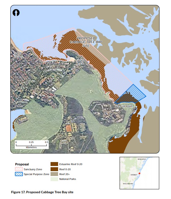
The proposed site extends the current Cabbage Tree Bay Aquatic Reserve (Figure 16) to Blue Fish Point. The protected area would include a 52 hectare sanctuary zone that extends the current reserve from Shelly Beach Headland to 250 metres north-west of Blue Fish Point (Figure 17) and a seven hectare special purpose zone at Blue Fish Point.
CURRENT MANAGEMENT
Cabbage Tree Bay Aquatic Reserve was established in 2002. It covers 18 hectares and extends from the southern end of Manly Beach at South Steyne to the northern end of Shelly Beach, encompassing all of Cabbage Tree Bay (Figure 16). Collecting, destroying or
interfering with all forms of marine life, whether dead or alive, is prohibited. Shelly Beach Headland Intertidal Protected Area (IPA) adjoins the aquatic reserve and protects a small intertidal area by way of a regulation under the Fisheries Management Act 1994.
SITE OBJECTIVES
The primary objectives for the proposed Cabbage Tree Bay site are to:
• enhance the conservation of marine biodiversity
• reduce risks to identified habitats of the bioregion
• promote marine ecotourism in the bioregion
• enhance the intrinsic benefits derived by the community from the marine estate
• enhance bequest values for current and future generations
• reduce conflicts between users of the marine estate
• provide enhanced recreational experiences for particular user groups
• enhance opportunities for scientific research, education and learning
• provide baseline monitoring areas (scientific reference sites)
• promote stewardship of the marine estate.
The secondary objectives that apply to this site are listed in Table 5.
ENVIRONMENTAL, SOCIAL, CULTURAL AND ECONOMIC VALUES
Cabbage Tree Bay is a very popular area for a wide variety of user groups, including scuba divers, swimmers, snorkellers and surfers. The existing aquatic reserve removed some previous sources of conflict – such as conflict between spearfishers and swimmers.
There is Zostera and Halophila spp. seagrass in the bay, primarily along the southern side, although this is currently unmapped.
Anchoring in this area is currently not permitted, although this is not well publicised, and vessels may be unaware they are anchoring in a seagrass area. Boating activity in the bay is significant during peak-use times, and user conflict between vessels and swimmers is not uncommon despite the small boating closure around Shelly Beach. The Bay provides safe haven for boats during strong southerly weather.
Cabbage Tree Bay is a west-facing embayment that provides protection from dominant south-easterly swells. This results in areas of sheltered beach and areas for seagrass to grow, which is uncommon on the NSW coast. There are areas of both intertidal and shallow
rocky reef that vary in exposure, with those on the eastern side of the headland most exposed. A number of threatened and protected species are known to frequent the area, including blue groper, green turtles, black rockcod and weedy seadragon.
Cabbage Tree Bay is part of the traditional lands of the Guringai (or Ku-ring-gai) people, and it is part of the Manly-Freshwater National Surfing Reserve. It is an area that has been regularly used for scientific research on rocky reef habitats.
Blue Fish Point is popular for recreational shore and boat-based fishing and for scuba diving. The location is considered hazardous in some swell conditions, and rock fishing fatalities have been reported here.
Some Ocean Trap and Line commercial fishing takes place in the area.
PROPOSED MANAGEMENT RULES
The proposal to extend the current reserve to 250 metres north-west of Blue Fish Point would prohibit all extractive activities in this zone except for Aboriginal cultural use (Table 28). This zone would also replace the existing Shelly Beach Headland IPA, which would increase protection of marine life and reduce the complexity of regulations.
Anchoring in seagrass habitat in Cabbage Tree Bay would also be restricted. Seagrass generally occurs at depths of eight metres or shallower, so anchoring inside much of Cabbage Tree Bay itself would be prohibited.
Courtesy moorings (including environmentally friendly moorings) or a designated anchoring area could be considered to manage boating access and use.
The proposed seven hectare special purpose zone at Blue Fish Point would prohibit hand gathering of marine invertebrates, except for lobster and abalone.
FEEDBACK FROM COMMUNITY ENGAGEMENT
The high environmental value of Cabbage Tree Bay was identified by peak conservation stakeholders – the National Parks Association of NSW and the Nature Conservation Council of NSW. The value of the existing Cabbage Tree Bay Aquatic Reserve was described
several submissions, including from Manly Council, as was a proposal to extend the current boundaries of the reserve, typically to Blue Fish Point. This reserve was often cited as a model for marine management in the bioregion that should be replicated. Safety concerns
about potential conflict between boats and passive water users were also raised.
NORTH HARBOUR
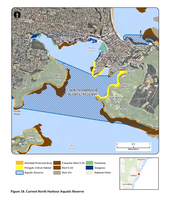
North Harbour includes the part of Sydney Harbour north of a line from North Head to Grotto Point. It includes Manly Cove, Spring Cove and all bays and beaches in this area.
The proposed site extends the current North Harbour Aquatic Reserve (Figure 18) to include all of North Harbour (Figure 19). Three new zones would be created: a 325 hectare special purpose zone, and two sanctuary zones with a combined area of 51 hectares, one at Fairlight and the other at Spring Cove.
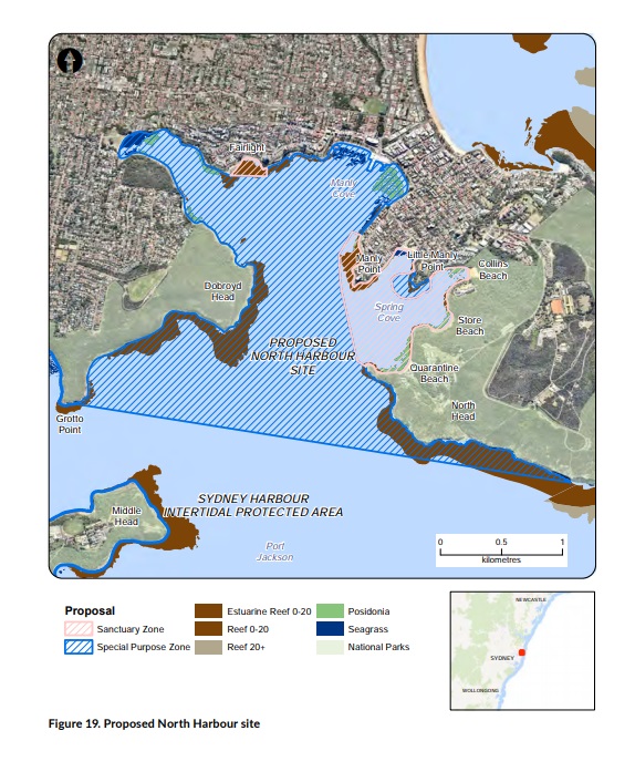
CURRENT MANAGEMENT
The 257 hectare North Harbour Aquatic Reserve (Figure 18) was established in 1982 and spans the area between North Head and Dobroyd Head. All marine species other than finfish are protected in the reserve, which allows line fishing for finfish only. All other fishing and collection methods are prohibited.
All of Sydney Harbour is closed to commercial fishing. Recreational fishing for shellfish is prohibited throughout Sydney Harbour. Netting, trapping, and spearfishing is prohibited in North Harbour. Sydney Harbour IPA also covers the coastline in North Harbour but not Manly Cove.
Little Penguin critical habitat restrictions include restrictions on fishing, anchoring, mooring and boating around Cannae Point and in Spring Cove. Courtesy moorings, including environmentally friendly designs, have been installed at Quarantine Bay and Manly Cove
West to reduce anchor damage to seagrass.
SITE OBJECTIVES
The primary objectives for the proposed North Harbour site are to:
• enhance the conservation of marine biodiversity
• reduce risks to identified threatened and protected species of the bioregion
• reduce risks to identified habitats of the bioregion
• promote marine ecotourism in the bioregion
• continue to provide for marine economic opportunities that are consistent with ecologically sustainable development, for example low-risk commercial fishing activities
• establish and maintain public infrastructure to support access and use of the bioregion, for example moorings, boat ramps
• enhance the intrinsic benefits derived by the community from the marine estate
• enhance bequest values for current and future generations
• reduce conflicts between users of the marine estate
• provide enhanced recreational experiences for particular user groups
• provide baseline monitoring areas (scientific reference sites) ensure appropriate mechanisms exist for community involvement in the management of the marine estate
• promote stewardship of the marine estate.
The secondary objectives that apply to this site are listed in Table 5.
ENVIRONMENTAL, SOCIAL, CULTURAL AND ECONOMIC VALUES
North Harbour includes a wide variety of habitats such as rocky shores, shallow rocky reefs, shallow soft sediments, beaches and seagrass beds. Most of the western shoreline and smaller areas of the eastern shoreline are rocky shore and subtidal reef. Threatened
and protected species are resident or are regularly observed in the area and include an endangered population of the seagrass Posidonia australis and little penguin. Dolphins and seals visit the area occasionally.
North Harbour area was used extensively by Aboriginal communities, known locally as the Gayemal clan of the Guringai tribe, who spent much of their time on the foreshores of Sydney Harbour. Spiritual sites and evidence of past cultural use, including art and
middens, have been recorded in the Aboriginal Heritage Information Management System. Important shipwrecks are also located in North Harbour.
The site is a focal point for boating (yachting, kayaking, power boats) and public and private on-water transport to Manly and other places. Scuba diving, snorkelling, swimming and on-water recreation are popular activities.
PRIORITY THREATS TARGETED TO ENHANCE BENEFITS AT THIS SITE
The threats that will be addressed at this site and expected benefits to be enhanced are listed in Table 29.
PROPOSED MANAGEMENT RULES
Recreational fishing and boating would be permitted in the special purpose zone, although existing restrictions on spearfishing and lobster fishing would continue (Table 30). Line fishing would no longer be restricted to finfish and would now include species such as squid. Other forms of hand gathering, including abalone fishing and collecting marine vegetation, would be prohibited. All forms of commercial fishing would be prohibited in this zone. Aboriginal cultural use and other low-risk activities such as scuba diving and snorkelling would be permitted in this zone.
In the proposed Fairlight and Spring Cove sanctuary zones, the removal or harm of marine biodiversity and habitats would be prohibited, including fishing by any method, hand gathering and collecting marine vegetation except for Aboriginal cultural use (Table 30). Anchoring would be prohibited in seagrass areas to prevent damage to the endangered Posidonia australis seagrass, and courtesy moorings would remain in place. Little penguin critical habitat areas would be included in the Spring Cove Sanctuary Zone.
FEEDBACK FROM COMMUNITY ENGAGEMENT
The high environmental value of North Head and North Harbour was identified by peak conservation stakeholders – the National Parks Association of NSW and Nature Conservation Council of NSW. Submissions proposed no-take areas at North Head, Spring Cove, and
Old Man’s Hat.
The Recreational Fishing Alliance reported that North Harbour is a safe and easy to access recreational fishing spot for the young, elderly and disabled.
Comments supported a no-take area in Sydney Harbour (including for a Sydney Marine Park). Other submissions (including from the Recreational Fishing Alliance and the Australian National Sportfishing Association) proposed that Sydney Harbour be declared a recreational fishing haven.
CHOWDER BAY
Chowder Bay is on the north shore of Sydney Harbour, near Mosman.
A 14 hectare site is proposed for Chowder Head and part of Chowder Bay (Figure 20).
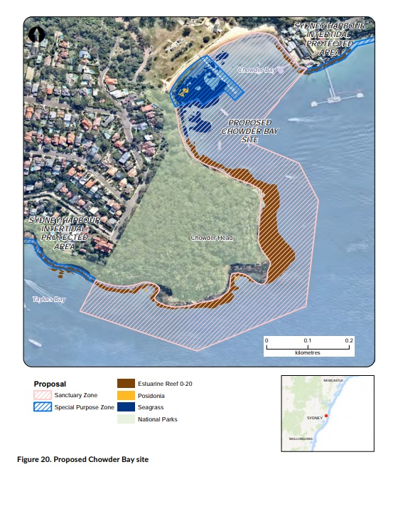
CURRENT MANAGEMENT
The shoreline of the proposed area is part of the Sydney Harbour IPA, which protects all marine invertebrates and cunjevoi.
Chowder Bay is currently closed to spearfishing as part of a closure under the Fisheries Management Act 1994.
SITE OBJECTIVES
The primary objectives for the proposed Chowder Bay site are to:
• enhance the conservation of marine biodiversity
• enhance the intrinsic benefits derived by the community from the marine estate
• enhance bequest values for current and future generations
• provide baseline monitoring areas (scientific reference sites).
The secondary objectives that apply to this site are listed in Table 5.
ENVIRONMENTAL, SOCIAL, CULTURAL AND ECONOMIC VALUES
Chowder Bay has shallow reefs and is used for marine education. It is next to the Sydney Institute of Marine Science. The area is used for passive recreation such as swimming, kayaking, snorkelling and scuba diving as the water is generally clear and has some protection from westerly winds. The proposed reserve excludes the popular and easily accessible fishing wharf.
The area has significance to the local Aboriginal communities. Spiritual sites and evidence of past cultural use, including art, have been recorded in the Aboriginal Heritage Information Management System.
PRIORITY THREATS TARGETED TO ENHANCE BENEFITS AT THIS SITE
The threats that will be addressed at this site and expected benefits to be enhanced are listed in Table 31.
PROPOSED MANAGEMENT RULES
A 13 hectare sanctuary zone is proposed for Chowder Head and part of Chowder Bay. In this zone, the removal or harm of marine biodiversity would be prohibited, including fishing by any method, anchoring in seagrass areas, harm to marine animals or plants, or collecting marine organisms whether dead or alive (Table 32).
Permissible activities would include those that are minimal–low risk, such as swimming, snorkelling, scuba diving and Aboriginal cultural use.
A 1 hectare special purpose zone is proposed for the area surrounding the jetty and swimming enclosure. In this zone, recreational line fishing would be permitted but spearfishing and hand gathering would be prohibited, in line with current management rules.
FEEDBACK FROM COMMUNITY ENGAGEMENT
The high environmental value of Chowder Bay was recognised by peak conservation stakeholders – the National Parks Association of NSW and Nature Conservation Council of NSW. The Sydney Institute of Marine Science states that this site is likely to be suitable for a baseline scientific monitoring site.
Comments supported a no-take area in Sydney Harbour (including for a Sydney Marine Park). Other submissions (including from the Recreational Fishing Alliance) proposed that Sydney Harbour be declared a recreational fishing haven.