Ingleside Planning Proposal rejected
At its February 17 2026 meeting the council resolved not to support the planning proposal for land at 1-9 Wilson Avenue, 7-14 Wilga Street and 212-222 Powderworks Road, Ingleside following extensive evaluation and community consultation.
The proposal sought to amend planning controls to facilitate 536 new dwellings along with environmental conservation areas and public open space. However, the proposal does not align with the Northern Beaches Local Strategic Planning Statement, Local Housing Strategy and other key planning documents.
Mayor Sue Heins stated the decision to reject the proposal was based on several significant concerns.
“The proposed development is inconsistent with local and regional housing plans, is not within a designated town centre, lacks access to high frequency public transport and community infrastructure required to support development of this scale”, Mayor Heins said.
“Council staff also identified major environmental issues, including the loss of endangered native vegetation and inadequate plans for bushfire risk management and safe evacuation.
During the exhibition period, Council received 606 submissions with an overwhelming 94% (567 submissions) objecting to the proposal.
“The community has sent a clear message that any new development must respect the character of our neighbourhoods and prioritise the safety and wellbeing of residents.
“Key community concerns included increased traffic congestion, environmental impacts, bushfire risks, insufficient infrastructure and the proposal’s incompatibility with the unique identity of Ingleside and Elanora Heights.
“Council remains committed to working with the community to deliver appropriate housing in suitable locations, in line with strategic plans and the values of the Northern Beaches,” Mayor Heins said.
'The applicant retains the right to request a rezoning review by the Sydney North Planning Panel and Council will keep the community updated of any developments', the council stated.
NSW Planning Department's SSD's
The proponent may also choose, now, to go straight past the council to the State Government and test out the SSD pathway for this proposal.
The NSW Government is using State Significant Development (SSD) pathways, managed by the Housing Delivery Authority (HDA), to accelerate large-scale housing projects, typically exceeding $60 million in capital investment. This process bypasses local councils for planning approvals, directly involving the Department of Planning, Housing and Infrastructure to speed up delivery.
Through the newly established Housing Delivery Authority (HDA), the state can fast-track large-scale residential projects and concurrently rezone land to facilitate higher density, such as turning low-density (R2) areas into medium-density zones.
The planning reforms enable the State Significant Development (SSD) pathways for housing to override local council zonings, allowing for increased density and rezoning, particularly within 800m–1200m of transport hubs.
However, State Significant Developments (SSD) and State Significant Infrastructure (SSI) in NSW can be approved away from established public transport. While state policy prioritises locating development near public transport to support sustainability, approvals are based on a merit-based assessment that considers economic, social, and environmental factors, allowing for exceptions.
With the upgrade of the Mona Vale West sections on track to commence construction in 2028, according to the
September 2025 Update, and now including constructing of a new local road connection between Bungendore Street and Powder Works Road, using the existing Harvey Road corridor, and extending the new local road east of Addison Road to meet the intersection of Mona Vale Road and Powder Works Road, other add-ins may also occur.
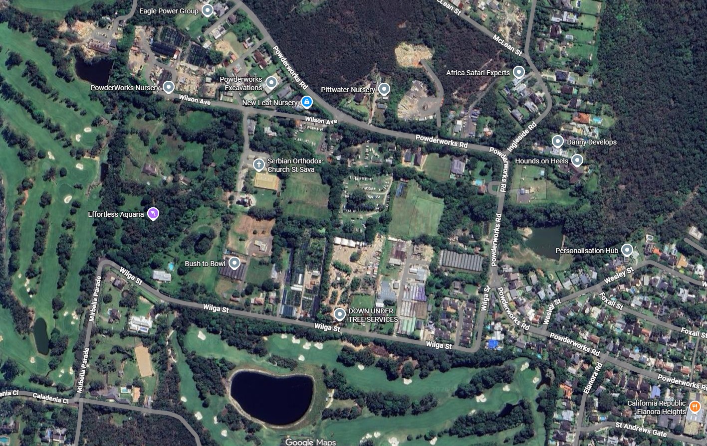
The 'Wilga-Wilson' proposal wanted to change zoning from RU2 Rural Landscape to R3 Medium Density, allowing new dwellings - including four six-storey apartment blocks (plus two bonus storeys), townhouses, and small-lot housing over the 14.248. hectare site.
Among the 22 documents tabled the proponents stated that at completion of the rezoning process, it is anticipated that the land will contribute 536 new dwellings, comprising 133 detached dwellings along the perimeter, 210 terrace and manor houses, and 193 apartments across four lots.
Wilga-Wilson site: Google Maps 2026
This project has had a few iterations.
In 2010 it was seeking a Site Compatibility Certificate to enable a seniors housing development of 850 independent living units, but was rejected by Pittwater Council.
In late 2016 it was among a proposal for close to 3,400 new homes and canned due to the high and unacceptable bushfire risks with no suitable route out for the thousands that would need to be evacuated in seconds.
The scheme was revisited in 2021, this time to rezone a smaller portion of Ingleside of approximately 980 lots, 420 of which were located within the 'Wilga Wilson Precinct', however, as the bushfire risk was still too high the then Planning Minister announced in mid June 2022 the plan would not be proceeding.
Two SSD's, one at Narrabeen and another at Mona Vale, are using this pathway, although neither has been approved, yet.
See:
Belrose SSD Approved
On February 5 2026 a State Significant Development application for Uniting Belrose Seniors Housing for a $194 million redevelopment was approved.
The approval allows demolition of the existing residential care facility and Manse House at 2B Morgan Road, Belrose. The project will deliver six new buildings ranging from two to five storeys.
The development includes 147 independent living units (ILUs) and 120 residential care facility (RCF) beds. It also provides a recreation centre, wellness spaces, café, salon, men’s shed, and 254 car parking spaces. The scheme has a total gross floor area of 26,973.7sqm.
The application relied on the State Significant Development pathway for large-scale seniors housing with residential care components, a pathway introduced in 2021. The site sits within the Locality B2 Oxford Falls Valley under Warringah LEP 2000, where seniors housing is permissible with consent.
The Department framed the proposal as a renewal of an ageing facility and noted the project responds to the needs of an ageing population. The location has access to public transport and proximity to established centres.
The Metropolitan Local Aboriginal Land Council raised issues relating to sediment and erosion control, road access, and the consultation processes. Forest Community Men’s Shed Inc expressed support for the development, as the mens shed on the site will be retained.
The Northern Beaches Council lodged an objection outside the formal exhibition period. The council reiterated earlier concerns about height, bulk and scale, urban design, parking, stormwater management, and residential amenity.
Height and bulk were the council's the most contentious issues. Council argued the proposal could set an undesirable precedent for the low-density character of the Oxford Falls Valley.
However, the Department accepted the applicant’s method for measuring building height. It relied on relevant case law and supported variations to the 8.5m height control, allowing buildings up to 14.3m. The assessment cited site topography, setbacks, and visual impact analysis as its key justifications.
Before construction begins, the proponent must satisfy several conditions. These include retiring biodiversity credits, finalising stormwater and groundwater strategies, and approving construction management plans. The NSW Planning Department’s report does not list any further statutory processes beyond standard post-approval compliance.
Construction will occur in stages. Subject to conditions, work is expected to start in late 2026.
The council also resolved not to support a separate planning proposal at 2 Abbott St, North Balgowlah for a dwelling house, as it would 'result in the loss of a long-established area of open space valued by the local community'. The council also stated it will write to the landowner and request the land be transferred to council ownership to be managed as public open space.
Related reports running this Issue, Week 4 February 2026, published Sunday February 22:
From Week 1 February 2026 Issue, published Sunday February 1:
2 Abbott St, North Balgowlah. Image: Google maps