We interrupt our usual celebrations of all things Aquatic associated with Pittwater to bring you some pretty appalling news from further north that has become apparent during the Easter break.
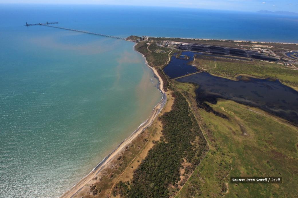
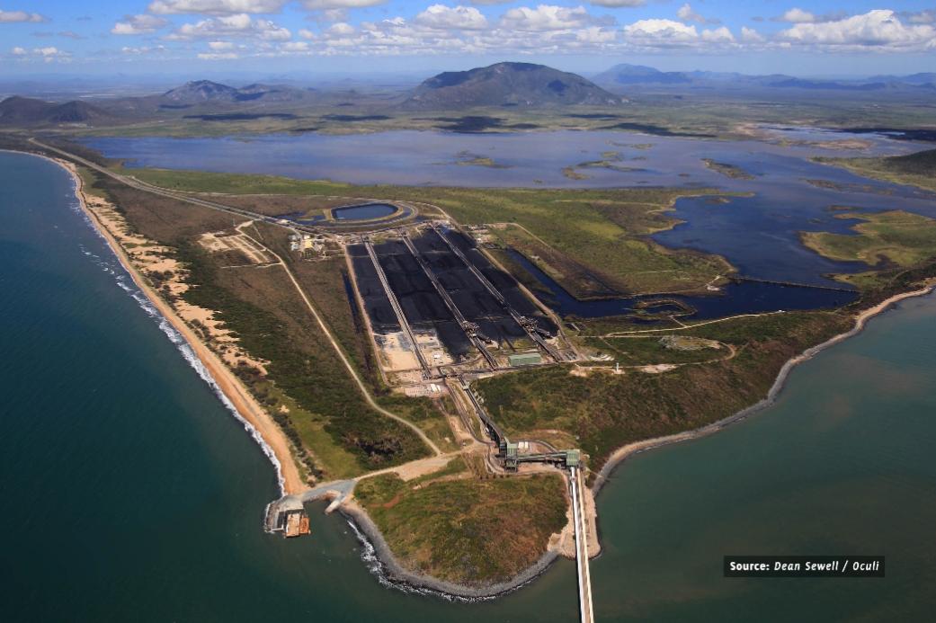
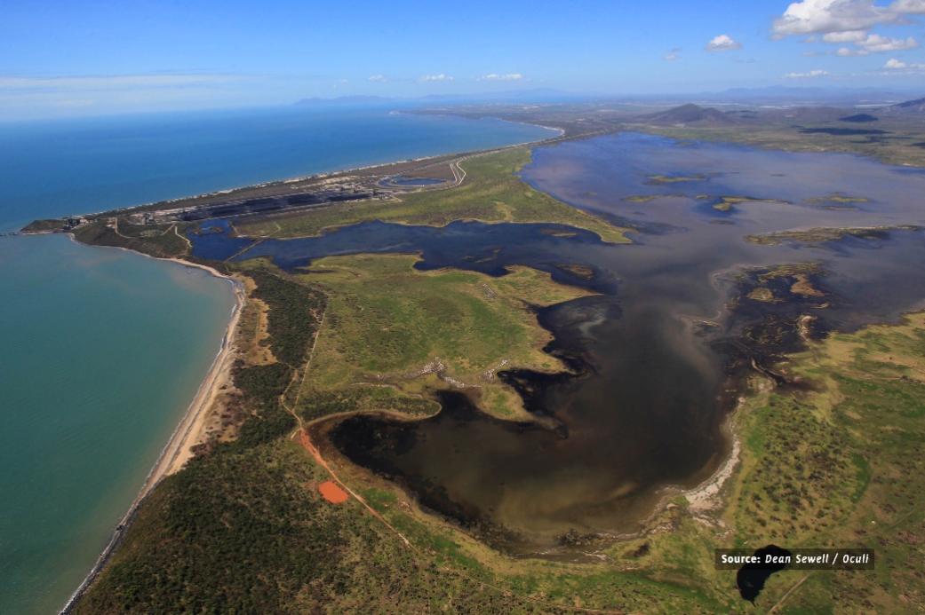
The Caley Valley wetlands have been polluted in the wake of Cyclone Debbie through coal-laden water spilling from the Abbot Point coal terminal.
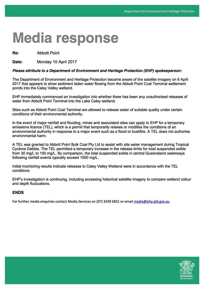
The QLD Department of Environment and Heritage Protection allowed terminal operator Abbot Point Bulk Coal, owned by Adani, to more than triple its "suspended solids" release limits in the wake of Cyclone Debbie, under what's called a Temporary Emissions Licence.
A department spokeswoman said that licence did not authorise environmental harm but Professor Brodie, James Cook University, professorial research fellow in water quality studies, has stated it was hard to see how the wetlands could emerge unscathed.
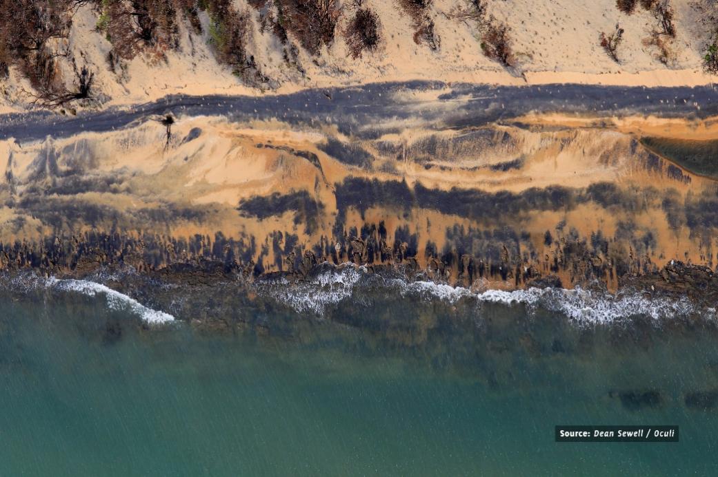
Mackay Conservation Group co-ordinator Peter McCallum, whose organisation released the images we run on April 11th, said they showed the wetlands had been "turned black by coal escaping from the port".
Adani stated testing conducted by them showed it had met the conditions of the temporary emissions licence (TEL) issued by Queensland's Department of Environment and Heritage Protection.
As Queensland experiences, on average, 4.7 tropical cyclones annually*, Temporary Emissions Licences may be issued as frequently.
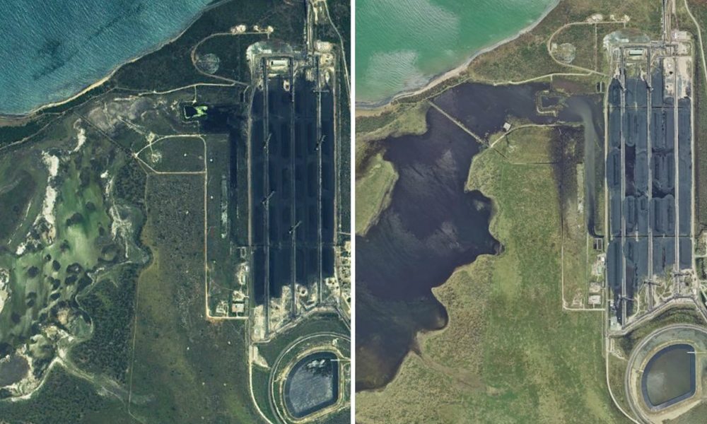
Satellite imagery released by the Queensland government. (Left) 14 May 2016 (Right) 1 April 2017. Photograph: Mackay Conservation Group
The Caley (Kaili) Valley Wetlands (the Wetlands) is a large, intact coastal wetland system located on the central Queensland coast approximately 25 kilometres (km) northwest of Bowen. The Wetlands cover an area of approximately 5,154 hectares (ha) and represents one of the few remaining intact wetland systems between Townsville and Bowen supporting valuable habitat and a wildlife corridor for a range of threatened flora and fauna species.
The Wetlands are a modified natural system that comprises of four out of the five main wetland systems within the Great Barrier Reef catchment, including - Estuarine, Lacustrine, Palustrine, and Riverine. There are at least six threatened native flora species within the Wetlands, remnant vegetation to the south that provides valuable habitat and a wildlife corridor of state significance, which connects the Wetlands to National Parks to the east and west.
The Wetlands are recognised as a nationally important wetland, under the Directory of Important Wetlands Australia (DIWA), and also meets, or once met, the criteria for being recognised as a Ramsar wetland of international importance.
In Issue 308 our Environment page ran a Media Release from Lock the Gate which notified all that the Queensland Government had granted, in secret, a 60 Year unlimited water licence to Adani for its proposed Carmichael coal mine, thus denying those born today any say, until 2077, in this matter, let alone anyone who can speak up right now.
“Adani is getting free reign to suck up as much groundwater as it wants until 2077, with no independent review during those 60 long years." the Lock the Gate release stated.
“This is a coal mine that is estimated to extract as much as 9,500 million litres of groundwater each year. The Queensland Government has failed to set a limit on the impacts to important aquifers, the Dunda Beds and Clematis Sandstone. Instead the government is letting Adani decide on acceptable limits in a report it’s meant to supply some time down the track."
Shamed into admitting the move, the QLD Government then issued their own Media Release, full of reassurances - both these run below.
This is the same government that won office in 2015 partly based on their pledges to save the Great Barrier Reef amid other assurances that announced... "We are the only party in this election that has committed to legislating the prohibition of commercial dredge spoil in the Great Barrier Reef," [1] and then gave the green light for the Adani mine to go ahead less than a month after winning the election. [2]
On Good Friday, April 14th, in an article published in Brisbane's Courier Mail, 'Abbot Point ‘coal spill’ pictures rubbished by experts', the claims have apparently been 'rubbished by by locals and experts, including scientists from the Department of Environment and Heritage Protection', all unnamed apart from Whitsunday Mayor Andrew Willcox, who said the blackened sand (above) was caused by a natural mineral called magnetite, found in sand, and that the as long as he could remember the mineral had always been found there. Mr. Wilcox, the Courier Mail reported, had even gone down there with a magnet to prove it.
Magnetite is ferrimagnetic; it is attracted to a magnet and can be magnetized to become a permanent magnet itself. So all Mr. Wilcox need do is get down there with the largest magnet ever to clean up the wetlands and the beach. Perhaps there is a belief that focusing on the beach and magnets or statements by unnamed experts will distract people from the black tide photographed seeping from the coal terminal into the wetlands.
The Townsville Bulletin followed this up by publishing an Editorial, 'Adani conspiracy blown out of the water' in which they stated that other black tide, away from the beach and into the wetlands, is actually showing "the natural reaction of freshwater hitting saltwater, turning it a dark colour which, when viewed from space, appears black".
The Editor unfortunately has mixed up the information shared in a Queensland Resources Council Media Release about the colours of water in a satellite image. The Queensland Resources Council is a 'not-for-profit peak industry association representing the commercial developers of Queensland’s minerals and energy resources'.
The other point being ignored is these other images weren't taken from space, they were taken by a drone and helicopter, and clearly show where that black tide flows from. They were taken on Tuesday April 11th, as the file's History shows.
All this begs the question of what is allowed and what are the conditions of the temporary emissions licence. The QLD Gov. webpage on this states an Application for a temporary emissions licence (Act, s357B(5)) 'A temporary emissions licence is a permit that relaxes or modifies specified conditions of an environmental authority. A TEL is a flexible tool that can be used to appropriately manage the environmental impacts of contaminant releases to the environment as a result of applicable events.' Cost $2438.00. The TEL document states;
"A TEL can be used
(a) for discharges to water when flood waters are due to reach the operation within hours or days
(b) when monitoring and reporting requirements related to contaminant releases cannot occur due to an applicable event preventing safe access
(c) to allow a waste transfer station to release contaminants (e.g. noise and odour emissions) associated with the acceptance of a volume of materials greater than its EA and/or for extended periods outside of their normal operating hours as part of a flood recovery after flood waters have receded
(d) to allow an operation to release contaminants (e.g. noise, water or air emissions) associated with operating 24 hours a day to aid in the reconstruction of infrastructure damaged as a result of an applicable event.
A TEL does not:
(a) manage the release of legacy water to the environment from mine sites or other environmentally relevant activities (ERAs) that are still affected by flooding issues that pre-date the commencement of the TEL mechanism
(b) remove the need for operators to manage their sites in accordance with the conditions of their EA at the end of the TEL, or to comply with unrelated conditions of their EA during the term of the TEL
(c) apply retrospectively to contaminant releases
(d) apply as a result of an accident occurring on site (refer to options below for mechanisms available to address accidents)
(e) otherwise retrospectively legitimise unlawful practices.
There is no express limitation on the period of a TEL in the EP Act, but the terminology ‘temporary’ indicates that these instruments are intended to be short term. As a general guide, it is unlikely that the immediate response to an event should take longer than 3 months."
This doesn't help determine how much of an 'emission' you can release into nearby areas or tell us who will pay for the clean up and the timeframe required for that. Nor does the QLD Government's:
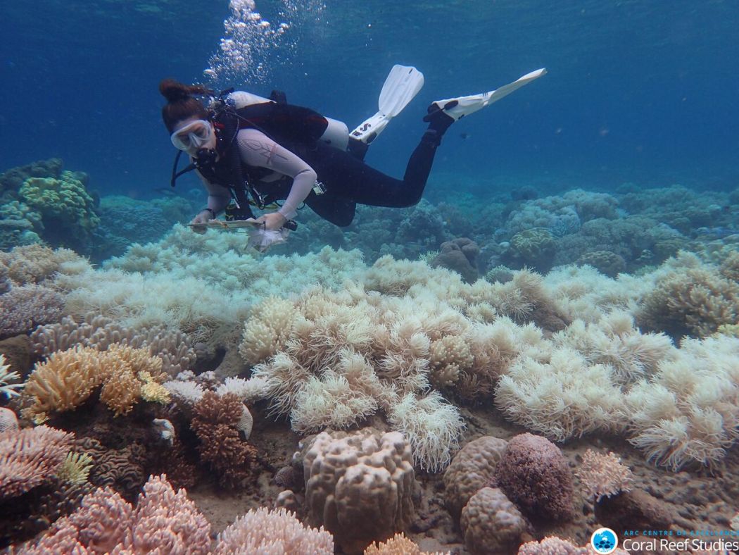
Add to this news of April 10th, the same day, from James Cook University scientists, who for the second time in just 12 months have recorded severe coral bleaching across huge tracts of the Great Barrier Reef after completing aerial surveys along its entire length, and things get blacker. In 2016, bleaching was most severe in the northern third of the Reef, while one year on, the middle third has experienced the most intense coral bleaching.
“The combined impact of this back-to-back bleaching stretches for 1,500 km (900 miles), leaving only the southern third unscathed,” says Prof. Terry Hughes, Director of the ARC Centre of Excellence for Coral Reef Studies, who undertook the aerial surveys in both 2016 and 2017.
“The bleaching is caused by record-breaking temperatures driven by global warming. This year, 2017, we are seeing mass bleaching, even without the assistance of El Niño conditions.”
In recent weeks news of the Federal Government's plans to help Adani with a one billion dollar loan to facilitate their building of a railway to the proposed 'multi billion dollar, providing thousands of jobs' Carmichael mine, although the Adani Media Release of March 31st 2015 stating 10 thousand jobs would be created was reduced under scrutiny to 1500 in the 2015 JOINT REPORT to the Land Court of Queensland on "Climate Change – Emissions", (2015) Adani Mining Pty Ltd (Adani) v Land Services of Coast and Country Inc & Ors" . On April 11th, in an The Australian report, PM’s native title fix for Adani mine, the 10 thousand jobs is still be quoted as credible.
Of course, giving 10 thousand people one million dollars each is another option for the taxpayers one billion...as long as they invest it in something in central Queensland...
Reactions have been long and generally opposed to the mine, including a number of major international banks that have publicly ruled out financing the Carmichael Mine and Rail Project, or the expansion of the Abbot Point Coal Terminal on which the Carmichael project depends. Community representatives have also voted with their money feet, the most recent being the Byron Council, as announced in Echo Net on April 20th, who will now blacklist Westpac for their refusal to publicly rule out financing the controversial Adani Carmichael coal mine and more their tens of millions elsewhere.
"One of the most beautiful and largest coastal Wetland in Queensland is in real danger of permanent damage as a result of the expansion of the Abbot Point Coal Ports, associated rail links and industrial development in the adjacent Abbot Point State Development Area." The Mackay Conservation Group states.
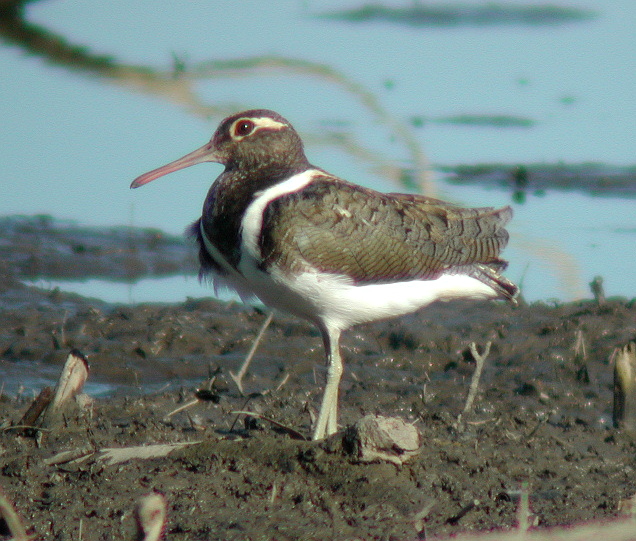
The 5,154 hectare Caley (Kaili) Valley Wetlands are alive with extraordinary bird life that can number over 40,000 in the Wet Season from October through April.
"Of the 200+ known species of birds that frequent the Wetlands, 3 are listed as threatened, including a nationally important population of the vulnerable Australian Painted Snipe. " the Mackay Conservation Group states on their landing webpage.
Australian Painted Snipe (Rostratula australis)- photo courtesy Aviceda
Queensland Premier Annastacia Palaszczuk has made no statement on the matter, however, the day the news broke, April 10th, she did issue a Media Release thanking Adani for donating $200,000 to The Salvation Army assist north Queensland victims of ex-Tropical Cyclone Debbie.
While most of us were out and about over the school holidays break, some perhaps helping those affected by Cyclone Debbie, many of us enjoying our own local wetlands and waterways, the Australian Conservation Foundation (ACF) and the Australian Marine Conservation Society (AMCS) released the drone and helicopter footage showing the extent of environmental damage to this nationally significant wetland caused by Adani’s coal spill at Abbot Point.
The footage of the polluted Caley Valley wetlands runs below. It shows that a thick black sludge has flowed from the Adani coal port into the wetland, smothering a large area of wetland. The adjacent beach and its waters, a turtle nesting ground, now appears to be scattered with lumps of coal.
As well as smothering the wetland’s vegetation and sediments, coal dust can release toxic heavy metals into the water including mercury and selenium
ACF President Geoff Cousins said:
“The wetland has turned coal black. It looks trashed. It’s a tragic and shocking picture of what the future of the Reef coast looks like if we don’t stop digging up coal,”
“As acknowledged by India’s former environment minister, Adani has an appalling track record. There is nothing to suggest it will be any different here at the doorstep of our most precious natural wonder the Great Barrier Reef.
“The Adani companies have proven they can’t be trusted with the environment and the climate. The idea that we’d spend public money propping up their operations beggars belief.”
AMCS Great Barrier Reef Campaign Director Imogen Zethoven said:
“The Caley Valley Wetlands today are a microcosm of what could happen to our Great Barrier Reef if the Carmichael mine and port go ahead,”
“If the Reef were a person, it would be crying out for help. In nearly 20 years it has suffered four severe coral bleaching events, 10 severe cyclones and four massive flood events washing huge volumes of pollution into its waters. It can’t take much more.
“The majority of Australians believe the state of our Reef is a national emergency and yet, rather than responding to the crisis, both the federal and Queensland governments are racing ahead to make the crisis worse. It defies belief,” Ms Zethoven said.
Dr Jon Brodie, of the ARC Centre of Excellence for Coral Reef Studies, said:
“It is highly likely that there is environmental harm due to the loss of light for the plants and clogging of fish gills with fine coal dust.
“Given the complexities of governance - the regulatory authority and port owner is the Queensland government and the port operator is Adani – it is vitally important to have a transparent, independent and urgent investigation of this environmental harm.”
Geoff Cousins and Imogen Zethoven recently led a delegation to India and toured other sites of environmental damage caused by Adani operations.
So instead of running glorious pictures of people enjoying pristine waterways, or visions of birds in wetlands, this Issue we run, thanks to the people standing at this 'coal face', the Mackay Conservation Group, a record of what has happened and wonder if those currently in the decision chairs have already decided this is one wetland the world can forgo.
Perhaps the Caley Wetlands aren't that important after all...
________________________________________
1. Queensland Election: Labor pledges $100m for Great Barrier Reef. Brisbane Times, online, January 14th, 2015
2. Qld Labor backs mega coal mines despite economic, climate warnings. Renew Economy, online. March 12, 2015
* Tropical Cyclones in Queensland. Australian Government Bureau of Meterology. Retrieved from http://www.bom.gov.au/cyclone/about/eastern.shtml
Kaili (Caley) Valley Wetlands
Baseline Report - February 2012
Two-Thirds Of Great Barrier Reef Hit By Back-To-Back Mass Coral Bleaching
April 10, 2017: James Cook University
For the second time in just 12 months, scientists have recorded severe coral bleaching across huge tracts of the Great Barrier Reef after completing aerial surveys along its entire length. In 2016, bleaching was most severe in the northern third of the Reef, while one year on, the middle third has experienced the most intense coral bleaching.
“The combined impact of this back-to-back bleaching stretches for 1,500 km (900 miles), leaving only the southern third unscathed,” says Prof. Terry Hughes, Director of the ARC Centre of Excellence for Coral Reef Studies, who undertook the aerial surveys in both 2016 and 2017.
“The bleaching is caused by record-breaking temperatures driven by global warming. This year, 2017, we are seeing mass bleaching, even without the assistance of El Niño conditions.”
The aerial surveys in 2017 covered more than 8,000 km (5,000 miles) and scored nearly 800 individual coral reefs closely matching the aerial surveys in 2016 that were carried out by the same two observers.
Dr. James Kerry, who also undertook the aerial surveys, explains further, “this is the fourth time the Great Barrier Reef has bleached severely – in 1998, 2002, 2016, and now in 2017. Bleached corals are not necessarily dead corals, but in the severe central region we anticipate high levels of coral loss.”
“It takes at least a decade for a full recovery of even the fastest growing corals, so mass bleaching events 12 months apart offers zero prospect of recovery for reefs that were damaged in 2016.”
Coupled with the 2017 mass bleaching event, Tropical Cyclone Debbie struck a corridor of the Great Barrier Reef at the end of March. The intense, slow-moving system was likely to have caused varying levels of damage along a path up to 100 km in width. Any cooling effects related to the cyclone are likely to be negligible in relation to the damage it caused, which unfortunately struck a section of the reef that had largely escaped the worst of the bleaching.
“Clearly the reef is struggling with multiple impacts,” explains Prof. Hughes. “Without a doubt the most pressing of these is global warming. As temperatures continue to rise the corals will experience more and more of these events: 1°C of warming so far has already caused four events in the past 19 years.”
‘Ultimately, we need to cut carbon emissions, and the window to do so is rapidly closing.”
Orpheus Island bleaching. Image: Greg Torda
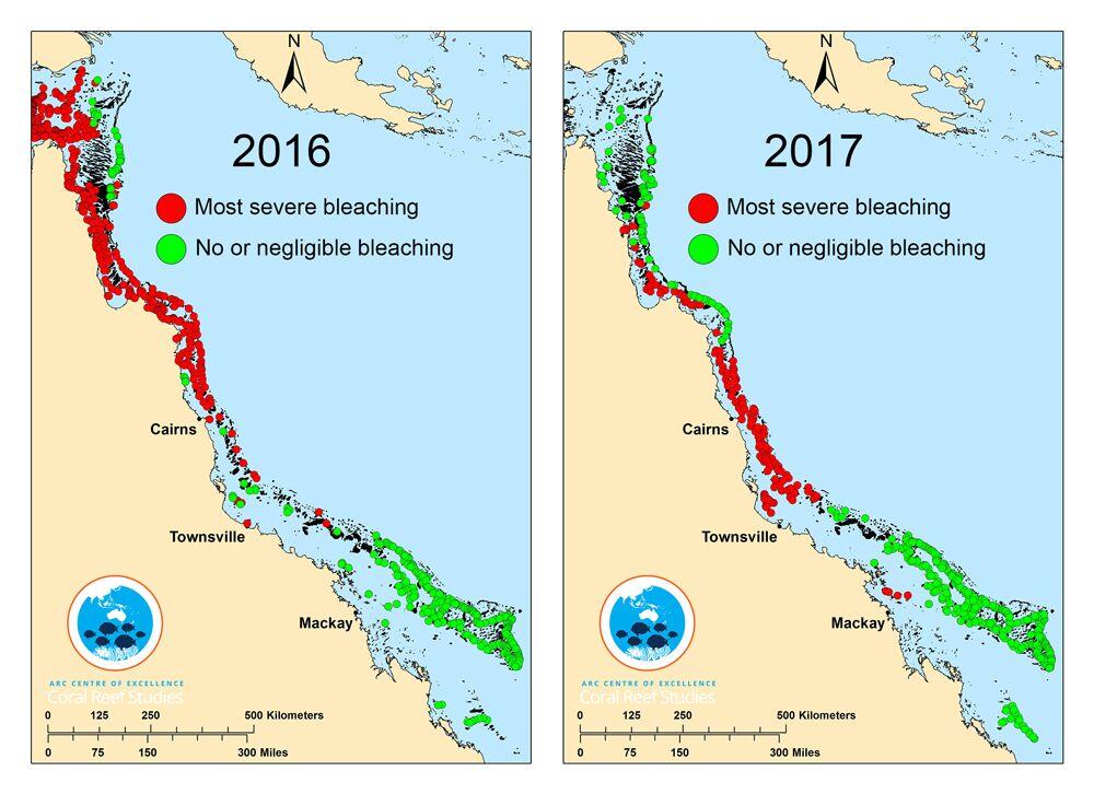
Not all data is shown, only reefs at either end of the bleaching spectrum: Red circles indicate reefs undergoing most severe bleaching (60% or more of visible corals bleaching) Green circles indicate reefs with no or only minimal bleaching (10% or less of corals bleaching).
Further
The two observers: Prof Terry Hughes and Dr. James Kerry work at the ARC Centre of Excellence for Coral Reef Studies at James Cook University in Townsville, Australia. The Centre for World University Rankings recently ranked this institution number 1 globally for Marine and Freshwater biology research.
The aerial survey techniques used in this study were employed consistently in all four bleaching events on the Great Barrier Reef: 1998, 2002, 2016 and 2017. They were backed up by extensive in-water research during the 2016 event and published in the peer-reviewed journal, Nature.
Coral bleaching occurs when abnormal environmental conditions, like heightened sea temperatures, cause corals to expel tiny photosynthetic algae, called ‘zooxanthellae’. The loss of these colorful algae causes the corals to turn white, and bleach͛. Bleached corals can recover if the temperature drops and zooxanthellae are able to recolonise them, otherwise the coral may die.
In the six months following the peak of bleaching in March 2016, scientists measured on average 67% loss of corals in the northern 700 km section of the Great Barrier Reef, which was the worst impacted section in that year. An interactive map of images and video of aerial survey footage from the 2016 event can be found here.
Terry P. Hughes, James T. Kerry, Mariana Álvarez-Noriega, Jorge G. Álvarez-Romero, Kristen D. Anderson, Andrew H. Baird, Russell C. Babcock, Maria Beger, David R. Bellwood, Ray Berkelmans, Tom C. Bridge, Ian R. Butler, Maria Byrne, Neal E. Cantin, Steeve Comeau, Sean R. Connolly, Graeme S. Cumming, Steven J. Dalton, Guillermo Diaz-Pulido, C. Mark Eakin, Will F. Figueira, James P. Gilmour, Hugo B. Harrison, Scott F. Heron, Andrew S. Hoey, Jean-Paul A. Hobbs, Mia O. Hoogenboom, Emma V. Kennedy, Chao-yang Kuo, Janice M. Lough, Ryan J. Lowe, Gang Liu, Malcolm T. McCulloch, Hamish A. Malcolm, Michael J. McWilliam, John M. Pandolfi, Rachel J. Pears, Morgan S. Pratchett, Verena Schoepf, Tristan Simpson, William J. Skirving, Brigitte Sommer, Gergely Torda, David R. Wachenfeld, Bette L. Willis, Shaun K. Wilson. Global warming and recurrent mass bleaching of corals. Nature, 2017; 543 (7645): 373 DOI: 10.1038/nature21707