Oceanography, Seafloor Mapping And Satellite Combine To Map World’s Strongest Current
December 19 2023 news by CSIRO
RV Investigator has been working for the last five weeks to understand how this natural barrier contributes to melting Antarctic ice shelves - and the potential for sea-level rise.
From space to the seafloor, an Australian and international research voyage has mapped a highly energetic "hotspot" in the world’s strongest current simultaneously by ship and satellite, and uncovered an underwater mountain range.
Halfway between Tasmania and Antarctica, the block of the Southern Ocean surveyed in high-resolution, three-dimensional detail stretches over an area of 20,000 square kilometres down through layers of swirling currents to the seafloor 4000 metres below.
The FOCUS voyage on CSIRO research vessel (RV) Investigator has been working in the Antarctic Circumpolar Current for the last five weeks to understand how heat leaking across this natural barrier contributes to melting Antarctic ice shelves and the potential for sea-level rise.
The voyage was designed to work with the new Surface Water and Ocean Topography (SWOT) satellite, jointly developed by NASA and the French space agency Centre National d’Études Spatiales (CNES) - enabling simultaneous mapping of fine-scale ocean features from the satellite and the ship.
Voyage chief scientist Dr Benoit Legresy said CSIRO, Australia’s national science agency, and the Australian Antarctic Program Partnership worked with collaborators and equipment from the US and France to tackle important climate questions.
“The ocean has absorbed more than 90 per cent of heat due to global warming and around 25 per cent of human CO2 emissions, providing an enormous service as a ‘climate shock absorber’,” Dr Legresy said.
“Knowing how to deal with human-induced climate change brings an urgency to tracking down the heat and carbon pathways in the global climate system.
“We’ve been working in a gateway where heat is funnelled towards Antarctica, contributing to ice melt and sea level rise. We need to understand how this gate works, how much heat gets through and how this may change in the future.”
While mapping the ocean currents, the companion mapping of the sea floor bathymetry has revealed ancient dormant underwater volcanoes.
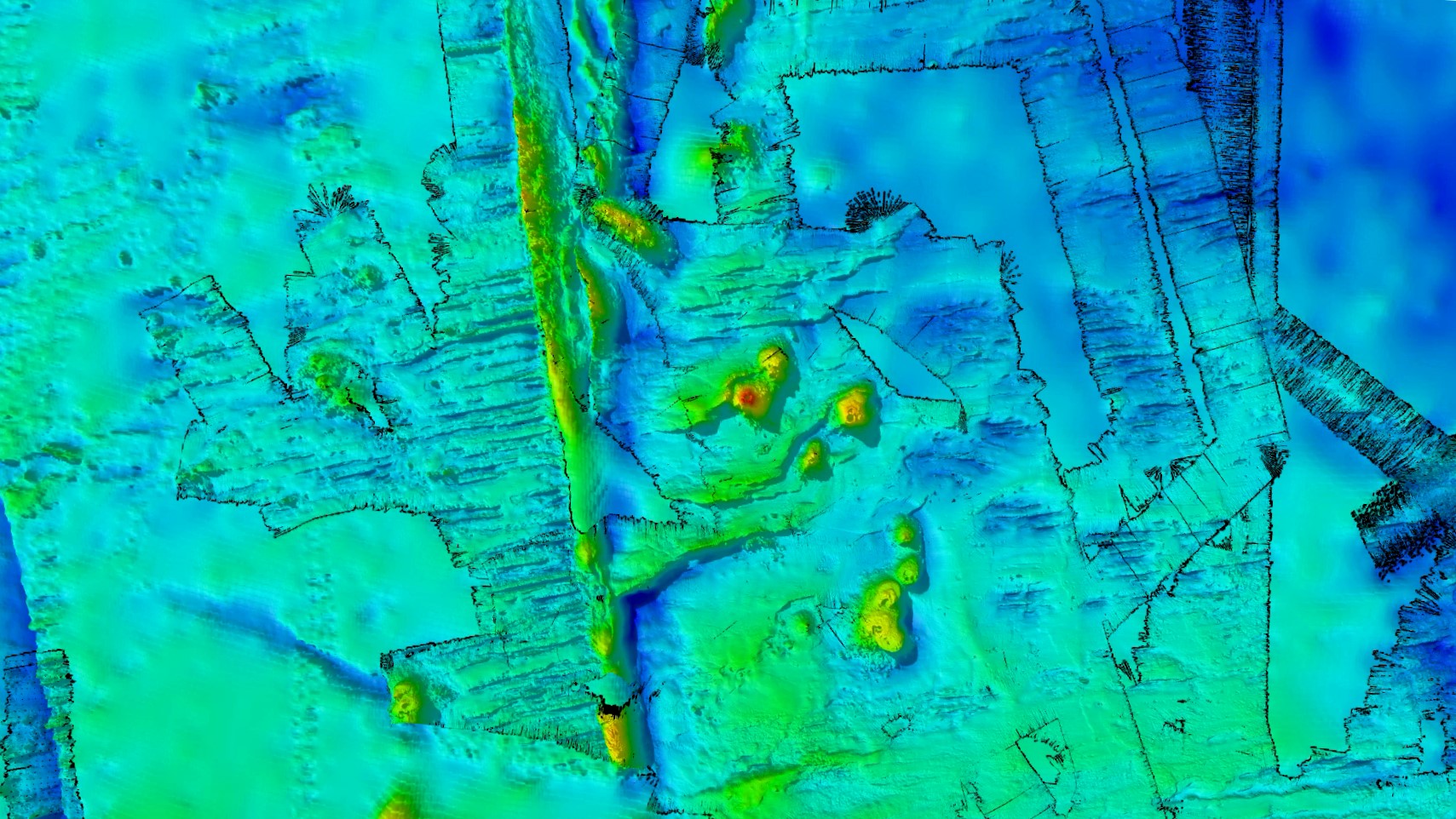
FOCUS survey area with newly mapped seafloor features. Photo: CSIRO
CSIRO geophysicist Dr Chris Yule said the team conducted high resolution mapping with RV Investigator’s world-class multibeam echo-sounder system. The survey spanned a seafloor area of 20,000 km2, most of which hasn’t been mapped before.
“To our delight, we’ve discovered a spectacular chain of ancient seamounts, comprising eight long-dormant volcanoes with peaks up to 1500 metres high and one with a double vent,” Dr Yule said.
“Four of them are new discoveries, and we filled in details on two seamounts and a fault line ridge partially mapped on a previous voyage. We now know the ridge, just west of the survey area, drops into a valley over a 1600-metre-high cliff.”
The survey area is 200 nautical miles (370 km) west of Macquarie Island and the tectonically active Macquarie Ridge. The seamounts were formed by volcanoes arising from hot-spot magmatism within the last 20 million years.
Voyage co-chief scientist Dr Helen Phillips, from the Australian Antarctic Program Partnership at the University of Tasmania, said new discoveries about the shape of the seafloor are vitally important to understanding ocean dynamics.
“The Antarctic Circumpolar Current ‘feels’ the seafloor and the mountains in its path, and where it encounters barriers like ridges or seamounts, ‘wiggles’ are created in the water flow that form eddies. Valleys and cliffs can also accelerate deep currents at the bottom of the ocean,” Dr Phillips said.
“Eddies are like the weather systems of the ocean, playing a major role in transporting heat and carbon from the upper ocean to deeper layers – a critical buffer against global warming.
“Knowledge of the depth and shape of the sea floor is crucial for us to quantify the influence of undersea mountains, hills and valleys on the Antarctic Circumpolar Current and the leaking of heat toward Antarctica.”
Dr Phillips said that while integrating all the ship and satellite data will take some time, the successful voyage is fundamental to building knowledge of ocean circulation that informs climate policy.
“Ultimately, we want to turn daily maps of ocean sea surface height from satellites into daily maps of the movement of heat in the Southern Ocean toward Antarctica. This will help governments and communities plan how to adapt to rising sea levels and how fast they need to act,” she said.
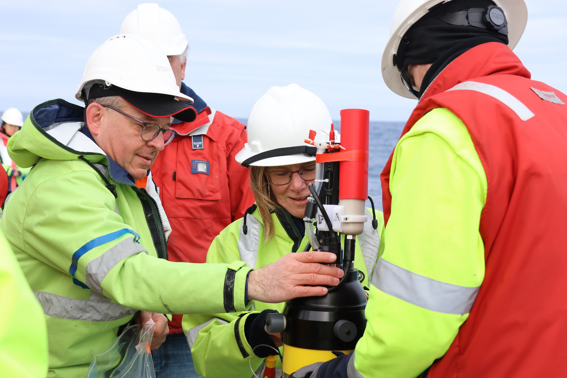
Voyage co-chief scientists Benoit Legresy and Helen Phillips preparing the EM-APEX float for deployment. Image: Amelia Pearson.
BY THE NUMBERS - The intensive ocean survey included:
- 111 casts of the CTD (Conductivity-Temperature-Depth) instrument at 70 monitoring stations around the edge of the survey area, 20 to the full depth of over 4000 metres
- between 12 and 24 water samples taken from each of the CTD casts to analyse salinity, dissolved oxygen, dissolved inorganic carbon, nutrients, phytoplankton communities and bacteria (1200+ nutrient samples analysed by the hydrochem lab on board)
- one giant tall mooring (the height of 11 Eiffel Towers) anchored in the centre of the survey area measuring salinity, temperature, oxygen, and current velocity from the seafloor 3600m deep to the near-surface every 10 minutes for the next 18 months
- mapping more than 90 per cent of the seafloor within the survey area to reveal a chain of double seamounts
- three robotic underwater gliders released from the ship to be piloted from Hobart and the US over the next six months
- 15 surface drifter buoys released through the survey area to track eddies in the current
- six Triaxus tows during satellite over-flights to provide a vertical slice from south to north of temperature, salinity and oxygen in the top 300 metres of ocean, for a distance of over 1000 km
- three BGC (biogeochemical) Argo floats released to measure ocean characteristics from the top 2000 metres of ocean depth
- two EM-Apex floats released to measure current speeds and ocean mixing
- hard work and fast learning by 13 early-career researchers providing valuable experience for oceanographers of the future
- more than 3500 nautical miles (6400 kilometres) travelled, on some days in 10-metre swell
The data collected from the voyage will be analysed by principal investigators in Australia, the United States and France to inform their research on the Antarctic Circumpolar Current and its role in global warming effects on Antarctica.
RV Investigator’s Longest Voyage To Try And Solve The Southern Ocean Puzzle
January 5, 2024 news by CSIRO
Scientists travelling as far as 65 degrees south will investigate why the deep ocean currents near Antarctica are slowing, whether the Southern Ocean will continue to absorb heat and carbon dioxide, and how clouds form over the Southern Ocean.
CSIRO’s research vessel (RV) Investigator sets off today on the longest voyage in its 10-year history to the Southern Ocean and sea-ice edge.
The aim of the 60-day voyage is to improve our ability to anticipate the impacts of future climate change.
The science teams on board, led by the Australian Antarctic Program Partnership (AAPP) and Australia’s national science agency, CSIRO, will search for climate clues between the deep ocean, up to six kilometres below the water surface, to low-lying clouds, two kilometres above in the atmosphere.
Co-Chief Scientist Dr Steve Rintoul, of CSIRO and AAPP, said the Southern Ocean takes up vast amounts of heat and carbon dioxide and acts as a handbrake on climate change, which means it has a profound influence on climate patterns in Australia and the rest of the globe.
“To anticipate how climate and sea level will change in the future, we need to understand how the Southern Ocean works and how sensitive it is to change,” Dr Rintoul said.
“What’s amazing about the Southern Ocean is that everything is interconnected – we can’t hope to understand how the region influences climate unless we measure each piece and how it fits with the other parts of the system.”
The voyage, known as MISO (for ‘Multidisciplinary Investigations of the Southern Ocean’), will explore how links between physics, biogeochemistry, plankton, aerosols, and clouds influence the Earth’s climate.
Changes in the Southern Ocean would have profound implications, influencing the rate of climate change, the productivity of the Antarctic ecosystem, and the future of the Antarctic Ice Sheet.
Changes in the Antarctic Ice Sheet, in turn, would affect the rate of sea level rise.
Recently published research has shown the “overturning circulation” of Antarctic waters driving global ocean currents may be slowing down, affecting the redistribution of heat, carbon and nutrients across the globe.
Co-Chief Scientist Dr Annie Foppert from the Australian Antarctic Program Partnership at the University of Tasmania said the meltwater from the Antarctic Ice sheet is reducing the amount of dense water sinking to the deep ocean around Antarctica, slowing ocean currents that control climate.
“Data collected on the MISO voyage will be compared to earlier measurements to track how the Southern Ocean is changing and what it means for climate and sea level rise,” Dr Foppert said.
“To track these changes in the deep ocean, we will deploy a dozen deep-diving robots.
“These new floats, able to collect measurements down to six kilometres below the sea surface, will allow us to track how the ocean is changing for the next five years by profiling the full depth of the ocean.
“Observing the deep ocean so regularly and over such large swaths was impossible before this new technology.”
The Southern Ocean takes up more of the heat and carbon added by human activities than any other latitude band on the earth.
“A key question is whether the Southern Ocean will continue to remove large amounts of our heat and carbon from the atmosphere, or will the Southern Ocean ‘sink’ become less effective as the climate warms,” Dr Foppert said.
“The Southern Ocean has essentially acted as a ‘climate shock absorber’ until now, but we need to probe the ocean depths to see if this will change in the future.”
Scientists onboard RV Investigator from the University of Tasmania and the Bureau of Meteorology will also study gases and particles released by tiny marine organisms called phytoplankton, grown in special aquariums mounted on the ship’s deck.
Gases and particles (or aerosols) released by the phytoplankton will be analysed to see how effectively they act as ‘seeds’ for new clouds.
Dr Marc Mallet, of the University of Tasmania, said understanding cloud formation in the southern hemisphere was a blind spot for climate science and model projections.
“This voyage will test the hypothesis that aerosols released by phytoplankton ’seed’ clouds and explain the unique properties of the Southern Ocean atmosphere,” Dr Mallet said.
“Improved understanding of cloud formation in the region will provide the foundation for more skilful weather and climate projections for Australia and the rest of the globe.”
The voyage will leave Hobart and sail south to the edge of the Antarctic ice travelling 9260 kilometres before returning to Fremantle in early March.
About the voyage
This voyage is supported by the Australian Antarctic Program Partnership (AAPP). The AAPP is funded by the Australian Government through the Antarctic Science Collaboration Initiative to better understand the role of the Antarctic region in the global climate system and the implications for marine ecosystems. The AAPP is a 10-year program established in July 2019 and is led by the University of Tasmania (UTAS) with core partners the Australian Antarctic Division (AAD), CSIRO, and the Bureau of Meteorology (BoM).
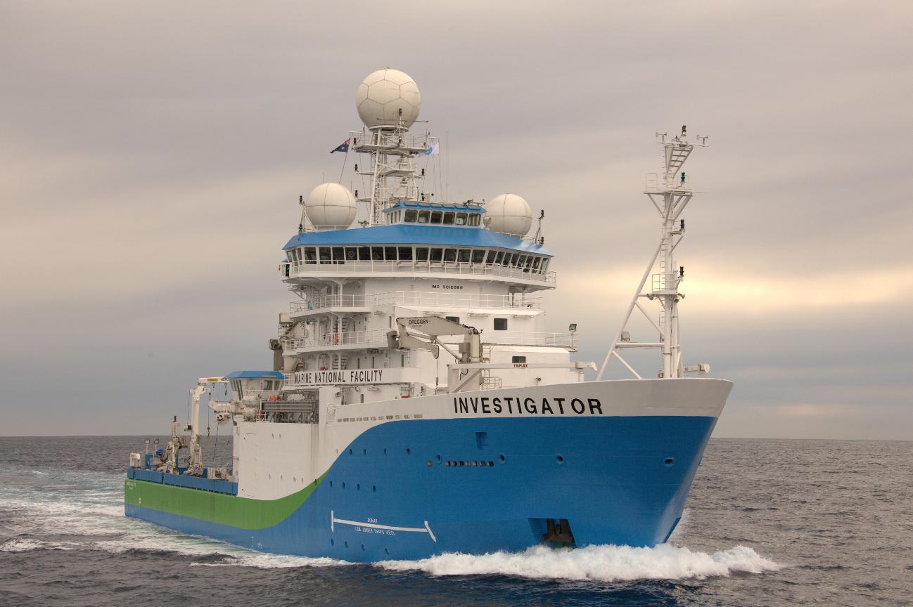
About RV Investigator
This research is supported by a grant of sea time on RV Investigator from the CSIRO Marine National Facility which is supported by the Australian Government’s National Collaborative Research Infrastructure Strategy (NCRIS).
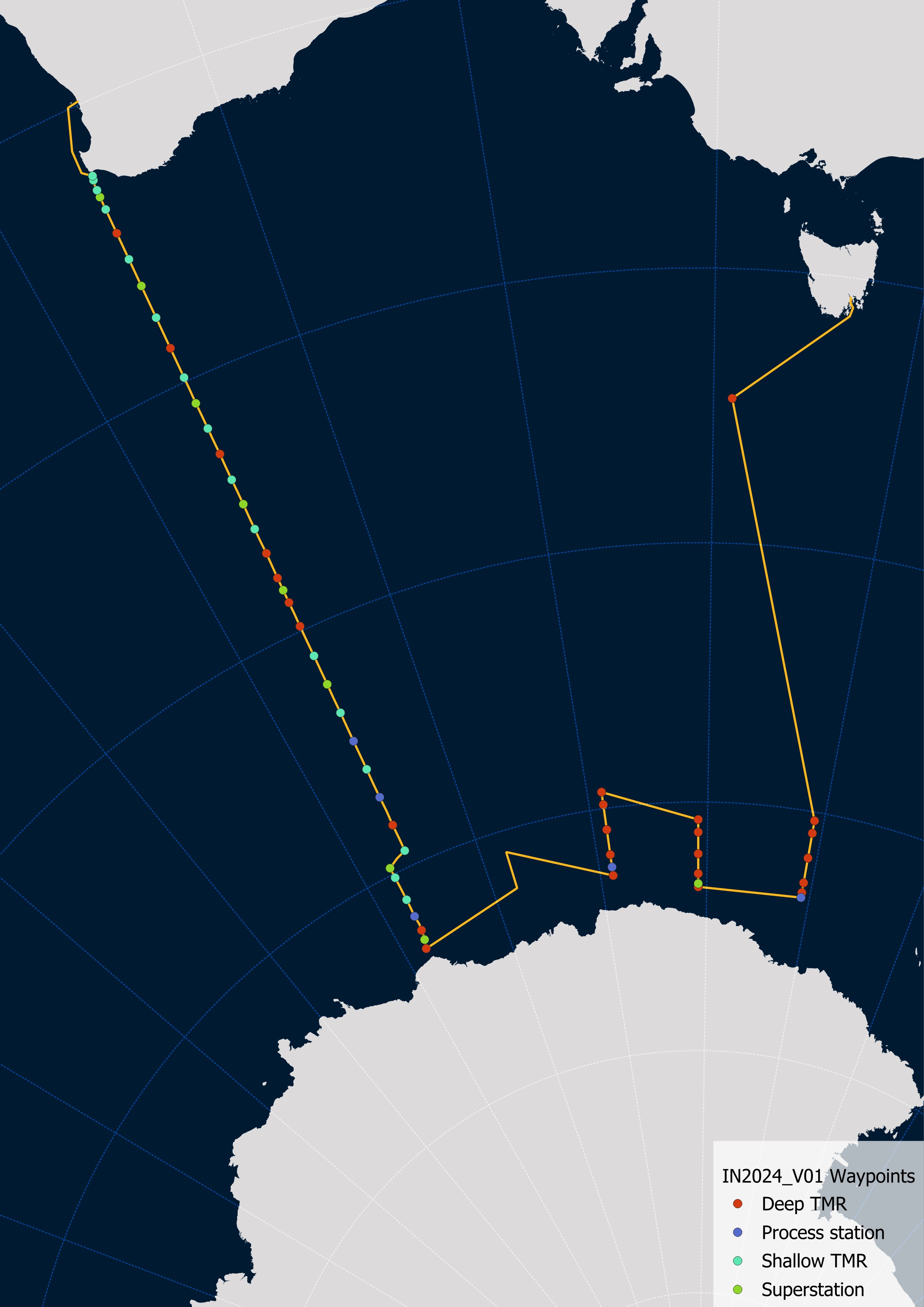
The RV Investigator will sail about 2300km south from Hobart to the edge of the Antarctic ice, before returning to Fremantle in early March in a 9260 km round trip. Image: CSIRO