Regional Boating Plan Launched For Community Comment
Monday, 11 August 2014
Member for Pittwater Rob Stokes today announced the NSW Government's Draft Regional Boating Plan for the Hawkesbury River, Pittwater and Brisbane Waters is now available for community consultation.
The Regional Boating Plan will help identify which projects will receive funding priority in coming years and help ensure these vital waterways are safe and accessible.
Community information sessions are being held throughout August and Pittwater is first up at 6pm on Tuesday 19 August at the Royal Motor Yacht Club, Newport.
"This plan shines a spotlight on our regional waterways and aims to identify projects which can deliver the greatest community benefit," Rob Stokes said.
"These waterways are used by thousands of local residents every day and it's vital they're safe, accessible and enjoyable.
"The Pittwater provides is a standout example of a thriving waterway that's relied upon by a huge variety of recreational, commercial and residential users.
"Feedback is being sought from all user groups to help ensure upcoming and future funding is correctly targeted.
"The Draft Regional Plan is available for viewing on the NSW Transport Website www.transport.nsw.gov.au/mmc
"Residents unable to attend the community information session can email their comments on the plan to mmc@transport.nsw.gov.au until 31 August, 2014.
"These are vital areas of our community and I encourage everyone with an interest to get involved," Rob Stokes said.
Consultation closes: Sunday 31 August 2014
___________________________________
Regional Boating Plan - Hawkesbury River, Pittwater and Brisbane Water Region - Consultation Draft August 2014
See draft at: www.transport.nsw.gov.au/sites/default/files/b2b/publications/201408-hawkesbury-pittwater-brisbane-waters-draft-boating-plan.pdf (6.72MB)
Community Information Sessions
Ettalong - Wednesday 20 August, Ettalong Diggers, 51-52 The Esplanade, Ettalong Beach 6:00-7:00pm
Windsor - Thursday 21 August, Windsor RSL, Mileham St and Argyle St, South Windsor, 6:00-7:00pm Sunday 31 August 2014
Regional Boating Plan - Hawkesbury River, Pittwater and Brisbane Water Region - Consultation Draft August 2014 - Copyright: 42 | Transport for NSW - Regional Boating Plan, 21/23122
Extracts from Consultation Draft
3.1 Analysis of waterway users
3.1.1 Licence data analysis
As of the 2011 census, there were 1,037,172 people living across the eight LGA’s in the Hawkesbury River, Pittwater and Brisbane Water region. The region generally experienced a population growth of 4.7% between 2006 and 2011, which was below the national average of 8.32% and the NSW average of 5.63%. It should be noted that two LGA’s experienced growth in excess of the State average namely Ku-ring-gai Council and The Hills Shire Council.
As of 12/03/2014 there were approximately 103,000 boat licence holders in the Hawkesbury River, Pittwater and Brisbane Water region.This represents approximately 19% of all boating licences in NSW, the greatest contribution of any of the Regional Boating Plan regions. The region also has the highest proportion (approximately 25%) of vessels over 6 metres in the State.
The majority of licence holders in the region carry a General Boat Licence with approximately 12% licensed to operate Personal Watercrafts (PWCs). This breakdown of licence types is typical across the State.
3.1.4 Future demand
In 2010, the then NSW Maritime released a report titled NSW Boat Ownership and Storage Growth Forecasts to 2026. The report forecast a continuing growth trend in vessel ownership of 2.9% annually across NSW.
The Report used a different regional profile to that being used for the Regional Boating Plan; however it identified the Hawkesbury/ Broken Bay region (which incorporates Pittwater) as one of the largest areas in the State in terms of boat ownership. The continuing population growth in the region together with high boat ownership of the current population supports the forecasted trend in vessel ownership.
4.Safety
Key findings
• Stakeholder consultation suggests high levels of satisfaction with current boating safety in the Hawkesbury, Pittwater and Brisbane Water Region with 85% of online survey respondents indicating they were at least satisfied with the region’s safety.
• The Nepean River has a high level of use by a range of different user groups with high use seen from passive craft, particularly rowers, PWC users and towing vessels.
• Beach areas, particularly within Pittwater, Broken Bay and Brisbane Water are popular for swimming and other passive activities where conflicting use often occurs.
• Stakeholder consultation suggests that the large contingent of vessels over 6 m regularly create excessive wash without consideration for other waterway users, especially on Cowan Creek, Broken Bay and Pittwater.
• Improved signage and navigation aids would help enhance the overall boating experience, especially in the narrow channels and entrances to Brisbane Water where shifting sand banks and siltation are an ongoing issue.
Actions
a. Review strategies to improve user behaviour across the region
b. Review the placement and planning of navigation aids and signage to improve navigation
4.2 Complaints
Analysis of the complaints received by Roads and Maritime during the five years leading up to 1 January 2014 reveals that the majority of complaints received relate to:
• On-water behaviour including irregular riding of personal watercraft, wash and vessels not observing correct distances off (25%);
• deficient moorings or vessels that are drifting (14%); and
• speeding (13%).
The most significant number of complaints received by the Roads and Maritime for the region related to the broad Brisbane Water area (25%). Localised areas that received a number of complaints included Pittwater, Berowra Creek, Woy Woy and the Nepean River (totalling to 32%).
Transport for NSW -Regional Boating Plan, 21/23122 | 19
4.3 Infringements
Between 2009 and 2013, the number of penalty notices issued within the Hawkesbury River, Pittwater and Brisbane Water region accounted for 12% of all infringement notices issued throughout NSW. Of the penalties issued over that period, approximately 79% were issued by Roads and Maritime, whilst the remainder were issued by NSW Police. In addition to these penalties, 2,882 formal warnings were issued. The highly trafficked waters of the Hawkesbury River accounted for more than a third of the region’s infringements.
As indicated in Figure 5 below, the infringements for which the most penalty notices were issued in the region were for:
• excessive speed (29%);
• failure to carry the correct safety equipment (28%); and
• failure to carry the required licence (10%).
4.4 Incidents
In the period between 1 January 2009 and 31 December 2013, there were 259 vessel incidents reported to Roads and Maritime in the region. Eighty-nine incidents occurred in Pittwater, 75 occurred on the Hawkesbury River, 44 incidents occurred in Brisbane Water and 28 incidents occurred offshore. The remaining 23 incidents took place in a range of locations including Berowra Creek, Cowan Creek, the Nepean River, Narrabeen Lagoon and Terrigal Lagoon. One hundred and ninety-nine of the incidents involved recreational vessels, 28 involved an interaction between a recreational and commercial vessel and 32 involved commercial vessels only. This breakdown of incidents among vessel categories is broadly consistent with State-wide observations.
4.4.1 Incidents resulting in death or injury
Ten fatal incidents have occurred in the region during this period, which resulted in 11 fatalities. All but one of these incidents took place during daylight hours and half occurred on a Sunday.
Vessel types that were involved in multiple incidents include open runabouts, cabin runabouts and canoes. The incident type was capsizing, fall overboard or a result of towing. Based on the data available, all but one of the deceased was not wearing an appropriate lifejacket and drowned. These victims may have survived had they been wearing a lifejacket at the time of the incident.
There were also 43 incidents which resulted in serious injury to the victim. A serious injury is classified as one requiring hospitalisation or outpatient treatment. These incidents resulted in 50 injuries, almost half of which took place on an open runabout. There was no particular trend or pattern when analysing the cause of incident, however, the most common incident type was injury on board followed by propeller incident. An additional 32 incidents resulted in minor injury to 39 persons; half of these were the result of collisions between vessels or capsizing.
4.4.2 Types of vessels
The main types of vessels involved in incidents, where known, were small powered craft (open runabouts 30%, cabin runabouts 14%), sailing vessels (21%), and larger motor cruisers (14%). PWC (5%), houseboats (3%) and canoes (1%) were not highly represented.
4.4.3 Incident locations
While incidents occurred throughout the region there are a number of areas where there were significant concentrations of incidents. These areas are:
• 20 incidents in Pittwater East from the Broken Bay entrance to Barrenjoey Head to Box Head;
• 19 incidents in Pittwater south of Church Point and Salt Pan Cove;
• 11 incidents on the Hawkesbury River between Sackville Reach and Kent Reach; and
• 11 incidents on the Hawkesbury River at Wisemans Ferry.
4.4.4 Incident cause
Behavioural and environmental factors were identified as the primary cause of the majority of incidents. Forty eight were caused by a lack of judgement, another 30 were the result of a lack of proper lookout and 30 incidents were the result of adverse weather conditions. Material factors were attributable to 21 incidents involving failure of a variety of equipment, machinery, electronics or hull; consistent with the State-wide average.
4.4.5 Incident type
Composition of incident types in the Hawkesbury River, Pittwater and Brisbane Water region was broadly consistent with State-wide averages. Over a third (92 incidents) involved collisions between vessels, which is slightly higher the State-wide average.
The next most common types of vessel incident observed in the region were vessel capsize (31 incidents), grounding (17) and collision with a fixed object (14).
4.4.6 Incident operation
Vessel operation at the time of an incident provides some insight into the nature of incidents occurring. While 143 were the result of vessels underway, 37 vessels were moored and 29 were at anchor or berth, which is a high proportion when compared to the rest of the State. Thirty three of the 92 incident collisions noted at Section 4.4.5 involved collisions with vessels that were moored, berthed or at anchor – mostly by vessels breaking their berths or moorings and colliding with other moored vessels. This finding also correlates with the high number of complaints summarised in Section 4.2 regarding moorings. Fourteen tow sport incident were
Transport for NSW -Regional Boating Plan, 21/23122 | 21
reported during the period, which is a slightly greater proportion than the State-wide average for waterways where towing occurs.
4.4.7 Time of day, month and year
Where the time of the incident is known, 211 occurred during daylight; 66 in the morning and 145 in the afternoon. Forty eight incidents occurred at night, with the majority of these (33) occurring before midnight. January was by far the most common month for incidents to occur. As expected, November, December and March also had a high proportion of incidents, corresponding to the most intense periods of boating activity. Similarly, weekends were the most likely days for incidents to occur.
5. Access
Key findings
• There are a relatively large number of waterway access points in the Hawkesbury River, Pittwater and Brisbane Water region. Despite this, there is a significant strain on capacity even amongst relatively new and well-managed facilities.
• Capacity of car and trailer parking does not meet demand at most access points. Car parking also restricts access to moorings, especially in Pittwater.
• More can be done to improve the condition of much of the region’s boating infrastructure, especially at the large number of wharves and jetties.
• There are a large number of residents in the region with waterway access only. These waterway commuters are heavily reliant on congested access infrastructure. This can impact upon the availability of infrastructure for recreational boaters.
• The Hawkesbury River covers a great distance and would benefit from the provision of strategically located access infrastructure to meet demand, spread waterway usage and cater for emergency response.
• There is a need to support the upgrade of rowing facilities with a view to sharing access with other passive boating uses including paddle craft.
• The Nepean River has relatively limited waterway access for the large growing population and the range of different waterway user groups it services.
Actions
c. Work with councils to improve the condition of key access facilities across the region to meet current and future demand
d. Work with councils to increase capacity and capability at existing access facilities with a particular focus on boat ramps
e. Work with councils to increase car parking for recreational boating access to moorings and jetties, especially in Pittwater, and increase car and trailer parking at boat ramps region-wide
f. Continue support for the Rescuing Our Waterways dredging program
g. Identify strategic locations for access development across the region specifically in Pittwater and the Upper Hawkesbury
5.3 Key findings
There are a relatively large number of waterway access points in the Hawkesbury River, Pittwater and Brisbane Water region. It is clear that there are four major areas in this region, these can be classified as:
• Pittwater including Broken Bay;
• Nepean and the Upper Hawkesbury;
• Lower Hawkesbury; and
• Brisbane Water.
This region has more jetties and wharves than there are boat ramps. This is likely due to the relatively large percentage of vessels over 6 m that are registered (both recreational and commercial) within the region that require access to wharves and jetties for ‘pick up and drop off’ of passengers and supplies. It is also due to the significant number of residents with waterway access only who require wharf and jetty access for commuting purposes.
Despite the large number of wharves and jetties, there is still a strain on their capacity with the competing demand for these facilities from both recreational boaters and commuters vessels. This issue of competition for access facilities is further outlined in Chapter 7. It was identified that several of the wharves and jetties in the Pittwater area require upgrading to maintain access at these locations.
Access to the waterway for trailered vessels at boat ramps is also strained with a significant proportion of the region’s boat ramps only able to accommodate a limited number of users due to:
• constraints in car and trailer parking;
• limited width of ramp;
• depth of ramp; and/or
• limited pontoon or jetty access.
The demand for many of these ramps is at capacity, if not already exceeded. In addition to the limited capacity, the condition of the boat ramps was identified to further restrict usage. This is seen to be a region wide issue although it is particularly prevalent in the Brisbane Water area.
This region has limited opportunities for creating additional public access points given the demand for waterfront property in Pittwater and Brisbane Water along with the large proportion of National Park. As such, locations for the development and expansion of car and trailer parking facilities to service boat ramps, wharves and jetties and mooring areas are scarce. Given these constraints it is vital that the existing boating access facilities are closely reviewed with the view to further optimise and upgrade.
5.4 Actions
c. Work with councils to improve the condition of key access facilities across theregion to meet current and future demand
d. Work with councils to increase capacity and capability at existing access facilitieswith a particular focus on boat ramps
e. Work with councils to increase car parking for recreational access to moorings and jetties, especially in Pittwater, and increase car and trailer parking at boat ramps region-wide
g. Identify strategic locations for access development across the region specifically in Pittwater and the Upper Hawkesbury
Similarly, Pittwater is congested by the large amount of boating taking place. An overall review of waterway and innovative strategies to reduce congestion both on water and on land will need to be considered to meet future demand. This may include provision to identify a new location to develop a new boating facility.
Table 6 – Perceived importance of storage issues – survey responses
Rank: 1 Lack of parking spaces 2 Physical accessibility 3 Cost 4 Amenity 5 Waiting list 6 Dinghy storage
6.3 Key findings
The Hawkesbury River, Pittwater, Brisbane Water region includes some of the more popular waterways in NSW, in part due to its proximity to Sydney and the highly urbanised surrounding suburbs. It has over 41,000 vessels registered in the region, large number of visitor vessels throughout the year and accommodates smaller crafts that do not require registration. As noted previously, this region also has one of the highest proportions of vessels over 6 m in the State. As noted in Section 3.1.4, there is a continuing growth trend in vessel ownership of 2.9% annually across NSW. Accommodating the region’s boat storage needs as vessel registrations and the size of vessels grow will require a balanced combination of additional on-water and dry storage options. Passive boating activities are also increasing in popularity in the region. While numbers are not easily identifiable since these vessels do not require registration, anecdotal evidence suggests that the popularity of these craft is growing at an even higher rate than that identified for registered vessels. Storage options for these vessels will therefore also need to be considered in this region.
Whilst open runabouts and cabin runabouts are still the predominant vessel type, sail vessels constitute a considerable portion of the total. This is evident in yacht clubs such as Royal Prince Alfred Yacht Club and Royal Motor Yacht Club in Broken Bay. These clubs have in excess of 500 berths between them. Compared to other regions, the region has a high proportion (over 50%) of private moorings licenced to hold sail craft. In Pittwater this rises to over 60% of the private moorings. This is significant and demonstrates a significant presence of sail craft in the region
The demand for additional on-water and on-land boat storage in this region is demonstrated by the long waiting lists for private mooring licences and commercial sites in a number of bays, the high occupancy rates, waiting lists for dinghy storage and the prevalence of boat trailers being parked on residential streets in the region.
In addition to what was observed on site there were also a significant number of issues in relation to storage raised by stakeholders. Some feedback received was similar to that received in regions such as Lake Macquarie – Tuggerah Lakes in relation to dinghy storage and mooring “minders”, and Botany Bay, Georges River and Port Hacking region in relation to trailer storage and the need for more berths and dry storage. However, some other feedback and findings from this region included:
• concern with the cost of dinghy storage as stakeholders felt that the storage was alreadyfunded from their licences and registrations,
• low maintenance and minimal amenities available at boating facilities;
• commuter vessels taking up on-water storage space;
• impact of current mooring systems on sea grass;
• lack of parking for trailers for medium and high density housing;
• trailer parking fees seen as high particularly in Pittwater;
• the demand for larger marina berths to accommodate larger vessels, and
• the need to phase out swing moorings in favour of berths and dry storage.
Other concerns and issues are captured in Chapter 7.
In 2013, the MMC developed the Sydney Harbour Boat Storage Strategy which examined the existing capacity and forecast demand for boat storage in Sydney Harbour. The Strategy seeks to identify the best way to accommodate growth by planning for the mix of storage facilities best suited to meet the characteristics of vessels and usage in the region. Adopting similar principles in the Hawkesbury River, Pittwater and Brisbane Water region will help achieve a common understanding of future boat storage requirements across all stakeholder groups.
Failing to plan for boat storage growth not only impacts on the experience of boaters in the region but also risks generating negative impacts for the community more broadly. As with other regions, dry storage, private moorings and other on-water storage including commercial marinas, need to be part of an overall approach for managing boat storage in the region. For example, there may be opportunities where Government funding can assist in establishing public marina facilities that could increase storage capacity while reducing the size of mooring fields.
Analysis from the consultation feedback and site visits has identified four key issues that would benefit from a more strategic approach to boat storage:
Demand for private moorings and on-water storage berths
A number of areas in the region have a significant waiting list in comparison to the total moorings. Some of the areas identified in Pittwater include:
• Horseshoe Cove;
• Winji Jimmi;
• Winnererremy Bay;
• America and Refuge Bays;
• Bayview Creek; and
• McCarrs Creek.
For example at Winnererremy Bay there are 26 listed on a waiting list for 17 moorings with the last mooring issued in November 2013. Similarly for Horseshoe Cove, the Roads and Maritime website notes the last mooring was issued in 2008 and “15 years plus possible size restriction” for one of 36 moorings which are predominantly sail craft.
Waiting list data reflects the feedback received from stakeholders and supports the demand for more on-water storage in the region such as private moorings and marina berths.
At the same time, navigation and access is often made difficult in and around some bays with high mooring numbers particularly at peak times. Examples of such bays and areas include Bayview, McCarr’s Creek, Salt Pan Cove and Careel Bay all with over 200 moorings. Other locations such as Parsley Bay, Brooklyn, Berowra, Refuge Cove, Scotland Island, Gosford, Koolewong, Hardy’s Bay and Saratoga all have over 100 moorings. Clareville was noted to having over 600 moorings. Some of these bays are also in close proximity to yachting/sailing clubs and are also adjacent to designated sailboat racing areas.
While there is a clear demand for additional private mooring licences, any further increase to mooring numbers would further impact on navigation and access in and around these congested mooring areas. A balanced approach is therefore required that optimises existing mooring configurations and identifies areas where future growth could be accommodated with minimal impact. Importantly, stakeholders also noted the need to provide more on-water storage such as marinas. This is the preferred type of storage for many boaters, especially amongst the ageing population due to ease of access. This is evident as many of the marinas in the region, especially in Pittwater, Cowan Creek and Brooklyn have waiting lists and high occupancy rates.
In March 2014, MMC released the Moorings Review Issues Paper which highlighted the potential for increasing mooring capacity through policy and regulatory changes and by using alternate moorings systems such as fore and aft or multi-point moorings. In addition, there may be opportunities where Government funding can assist in establishing public marina facilities that could increase storage capacity while reducing the size of mooring fields.
It is noted that alternate mooring systems are not suitable in all areas and may be subject to planning requirements.
Further information about the Moorings Review is available at: www.transport.nsw.gov.au/engagement/moorings-review-issues-paper.
Other issues such as concerns in relation to zoning as well as the treatment of moorings in the Pittwater Local Environmental Plan 2014 are further discussed in Chapter 7.
Dry Storage
Currently, there is a dry storage facility at Akuna Bay (169 spaces) and some hardstand storage at Newport (72 spaces) and minimal facilities in other areas
Dinghy and passive craft storage
Similar to other urbanised regions, a considerable majority of private mooring licence holders in this region are from suburbs adjacent to the waterways or in close proximity. Dinghies and other passive craft owned by foreshore residents are mostly stored on private land having exclusive access to waterways; this was observed at a number of foreshore residences. However for the other dinghies and passive craft, there was evidence of informal dinghy storage in several areas such as Careel Bay, along the foreshores of Palm Beach (suburb), Cowan Creek, Clareville Beach, Newport and Gosford.
Issues were identified regarding the lack of storage for growing numbers of other passive craft such as paddle craft in Pittwater, sailing dinghy storage in Gosford, rowing and dragon boats across some parts of the region. Conversely, some stakeholders noted that the provision of formalised dinghy storage modifies the character of the region and there should be some places where less formal storage methods is allowed to continue.
Long-term trailer parking
Boat trailer parking on residential streets has been identified as a key issue in a number of suburbs including around Lower Portland, Mona Vale, Terrigal, Davistown, Saratoga, Mooney Mooney, Church Point, and Palm Beach and generally around Pittwater. These are areas where trailers are being left parked on a long-term basis and also where there is limited short-term parking for trailers at boat ramps. Stakeholders also highlighted the fact that in new residential areas such as Penrith where new blocks are relatively smaller, there is little opportunity to store boats on private land.
In 2013, MMC released a report from a Boat Trailer Working Group established to investigate options to better manage long-term boat trailer parking. The report (www.transport.nsw.gov.au/publications-reports/boat-trailer-working-group-report) highlights a number of opportunities to reduce the incidence of long-term boat trailer parking on residential streets. The Government’s response to the options identified in the Boat Trailer Working Group report is expected shortly. The response will include additional funding to assist Councils, or other organisations, in establishing dedicated long-term boat trailer parking facilities.
 6.4 Actions
h. Establish a boat storage strategy for Pittwater.Work with councils and other partners to help deliver projects that support strategic growth in boat storage capacity in Brisbane Water and the Hawkesbury River
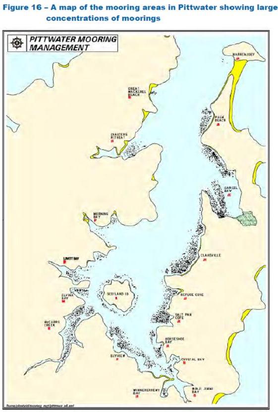
MMC and Roads and Maritime will work with Pittwater and other relevant councils to develop a boat storage strategy that seeks to identify the best mix of boat storage facilities required keep pace with demand in the Pittwater to Broken Bay area (Figure 15 and Figure 16). Developing the strategy will require further consultation with boat owners, industry and the local community. Once finalised, funding assistance will be provided to help councils and potentially other delivery partners to deliver new storage projects that support the agreed growth targets.
MMC and Roads and Maritime will also work with councils in Brisbane Water and the Hawkesbury River to identify a list of priority boat storage projects that will deliver the greatest strategic benefit. Other stakeholders and the general public are also encouraged to identify specific project that will improve boat storage in the region.
Potential opportunities to improve boat storage are identified in the analysis contained in Chapter 8.
i. Optimise configurations of existing mooring fields to improve access and navigation in the region and enable future growth as required
The boat storage strategy for Pittwater including Broken Bay will also inform the optimal number of moorings required in the region. In the interim, opportunities will also be explored to reduce waiting lists by methods such as optimising existing mooring configurations and identifying alternate areas where future growth could be accommodated with minimal impact.
As noted in the recently released Moorings Review Issues Paper, there are also likely to be opportunities to reduce waiting lists through more active compliance aimed at reducing the number of “mooring minders” in the region.
j.Provide dinghy storage for areas with high concentrations of moorings and passive craft storage in areas with high demand. Work with Pittwater Council to update existing dinghy management policies.
There is an opportunity to provide dinghy and passive craft storage racks and systems in areas with a high concentration of moorings or where there is demand for passive craft storage, as detailed in Chapter 8. Further opportunities to install dinghy and passive craft storage systems will be identified during consultation on this plan and through the development of a Pittwater boat storage strategy (Figure 15).
However for Pittwater, there was consistent feedback on dinghy and passive craft storage, there may be benefit to updating Pittwater Council’s dinghy management policies as described at www.pittwater.nsw.gov.au/recreation/boating_facilities/dinghy_storage to match supply with demand. This together with ensuring storage facilities are effectively managed and maintained will enhance the boating experience in the region.
k.Work with councils to improve long-term trailer parking capacity
In 2013, MMC released a report from a Boat Trailer Working Group established to investigate options to better manage long-term boat trailer parking. The report (www.transport.nsw.gov.au/publications-reports/boat-trailer-working-group-report) highlights a number of opportunities to reduce the incidence of long-term boat trailer parking on residential streets. The Government’s response to the options identified in the Boat Trailer Working Group report is expected shortly. The response will include additional funding to assist Councils, or other organisations, in establishing dedicated long-term boat trailer parking facilities.
NSW Regional Boating Plans
The Maritime Management Centre within Transport for NSW (TfNSW) together with Roads and Maritime Services is undertaking a state-wide study of existing boating facilities and safety measures to inform the development of Regional Boating Plans for each of the major waterways in NSW.
The study will identify the actions required to enhance the boating experience across NSW by improving boating safety, boat storage and waterway access on our major waterways.
Study area
The study area for this project has been broken down into 11 regions, as shown in the map below.
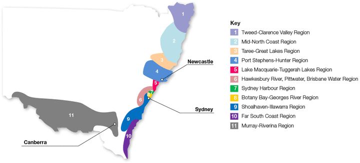
Each region contains significant waterways that will be investigated for the development of the Regional Boating Plans. Inland lakes and dams have been allocated to their closest region.
Stakeholder engagement
A comprehensive stakeholder engagement program has been developed to ensure we capture input from a variety of stakeholders ranging from high-level industry and stakeholder groups to everyday users of boating facilities.
The first stage of this program involved an initial round of consultation with councils and other stakeholders to gain an understanding of the key boating issues in the region.
An on-line survey was also conducted to seek input from the general public and boating community on the key boating safety, storage and infrastructure issues in the respective regions.
Input received through this first stage of stakeholder engagement is being used to produce draft Regional Boating Plans for each of the 11 major boating regions in NSW.
As each draft plan is produced, it will be available on the NSW Government Transport website (page link below) and comments can be made to mmc@transport.nsw.gov.au.
In addition, public information sessions will be held in each region to present the key findings for the respective draft Regional Boating Plans and provide an opportunity for attendees to have their say on the draft plan.
Feedback received from the public information sessions and comments emailed to mmc@transport.nsw.gov.au will be used to finalise the Regional Boating Plans which will be released later this year.
More information at: www.transport.nsw.gov.au/content/nsw-regional-boating-plans