Regular Readers will notice there's a few sculptures and sculpture stories appearing in recent Issues. This is about us all getting excited and talking of The Northern Beaches Coast Walk Public Art. In fact, we've been doing a few road trips to look at the various examples elsewhere that respond to the Principles and Themes outlined for here.
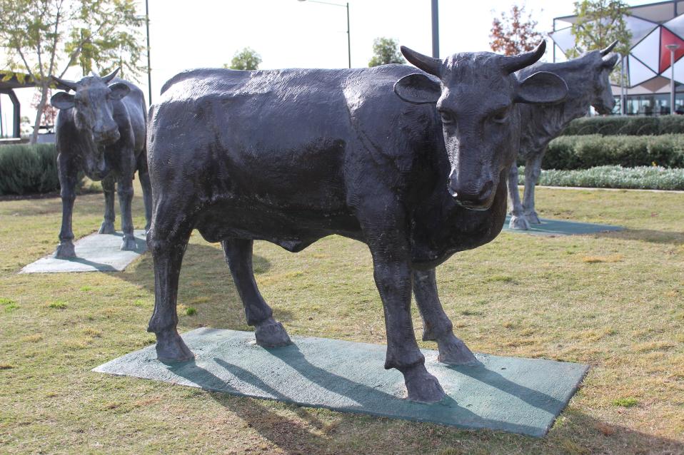
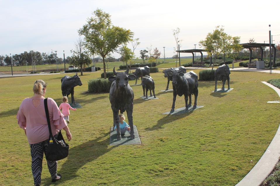
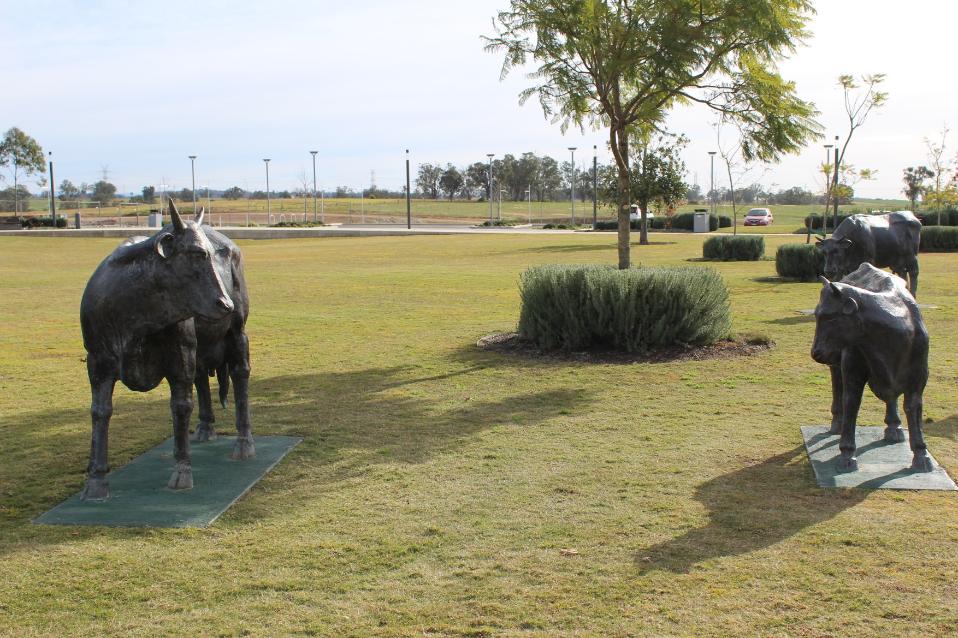
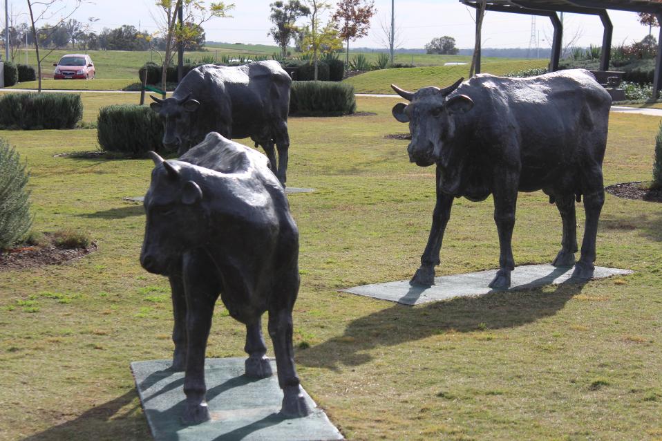
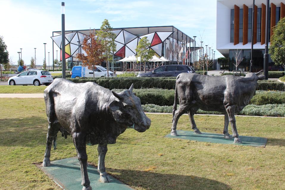
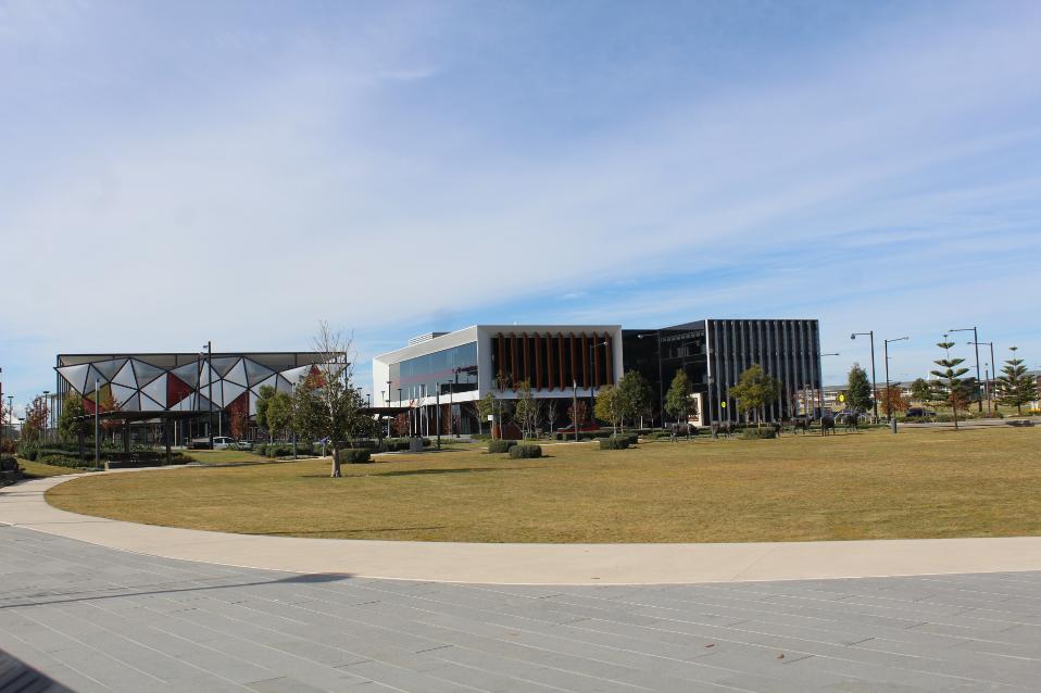
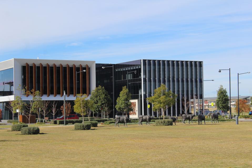
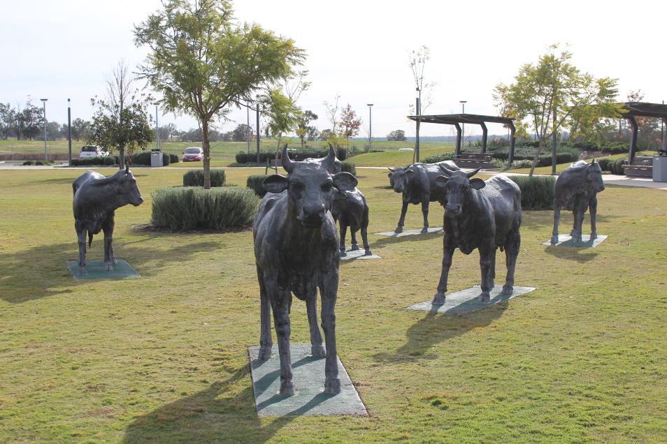
This example was donated to the community by the Perich family who are behind the Oran Park Town developments. This group were builders of the brand spanking new Award winning library on the verge of where this set of statues/sculptures are, delivered under a Voluntary Planning Agreement between Camden Council, Urban Growth NSW and Greenfields Development (Perich company).
.JPG?timestamp=1561003279019)
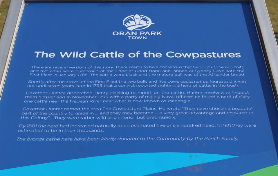
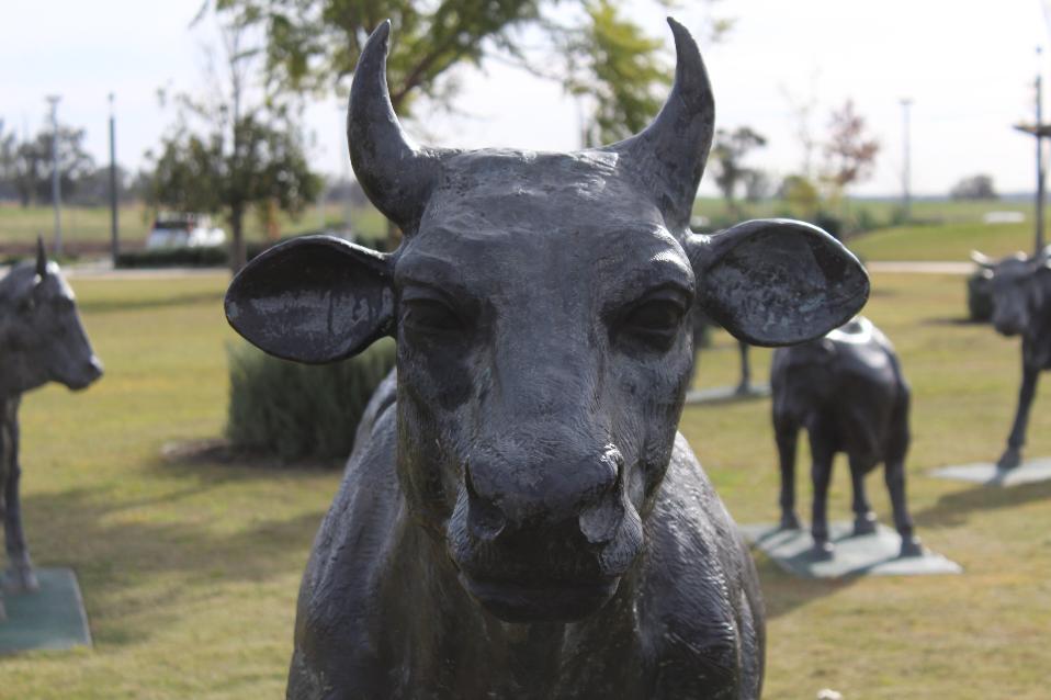
The cows speak of the former dairy lands these green fields once were and of the History of Cowpasture road and area more specifically. The idea is that future residents will be reminded of the First Fleet cows that strayed into the bush in 1788, followed creek corridors in the present Oran park Town and were found near Narellan on what settlers called 'Cowpastures'.
The Perich family's gift as an example also may bring into the conversation the contribution those who are developing parts of our area may make towards beautifying it as well. There are several kinds of parks being installed in Oran Park Town as part of that development from those devoted to exercise, replete with exercise equipment, to dedicated off-leash dog areas with dog exercise and activity equipment as well!
The cow herd is not the only item of interest in this park as there is a dedicated 'walk' here as well, and this too is to honour history, only in this case it is a few generations on from those cows.
On August 17th, 2017 the official opening of stage one of the Oran Park Raceway Walk of Fame took place. The Walk of Fame starts across the road from the Camden Council Building and will eventually stretch the whole length of the Oran Park Podium.
Dick Johnson, Allan Moffat, Lady Margaret Brabham (representing the Late Sir Jack Brabham) and Beverley Brock (representing Peter Brock) attended the opening.
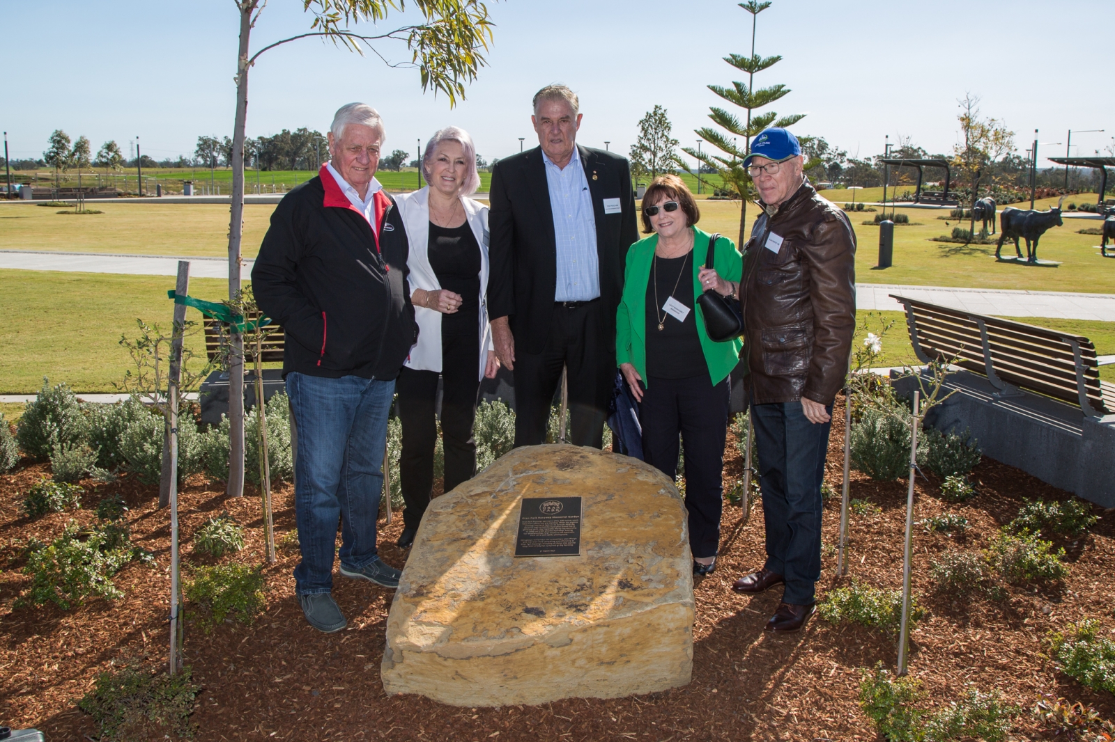
Photo courtesy Oran Park Town media.
.JPG?timestamp=1561068006789)
The first stage of the Walk of Fame features the following motor racing personalities, all of whom had a connection to Oran Park Raceway; Sir Jack Brabham, Wayne Gardner, Mick Doohan, Alan Jones, Peter Brock, Dick Johnson, Allan Moffat, Mark Skaife, Craig Lowndes.
.JPG?timestamp=1561068247842)
The developers also unveiled a memorial to all drivers and officials who lost their lives at the Raceway on the same day.
.JPG?timestamp=1561068308118)
.JPG?timestamp=1561068475343)
Tony Perich, head of the Perich family, stated at the opening that it was important to keep the memories of the track alive.
“I think it’s important to honour Oran Parks history which revolved around motor racing and cows so we’ve tried to create both with the cow statues here and the walk of fame,” he said.
“The path will stretch all the way down to the podium and there are 30 names on the list. It’ll all be finished by 2020.”
Although statues/sculptures of cows (and an 'Golden Calf/idolatry' association cause of rejection) or paying tribute to legendary race car drivers may not be suitable or applicable here, these two examples in the one place show the gamut of what is obviously a costly dedication to the community in the cow herd and something equally appealing but also a lot simpler and probably a lot less costly in the other.
The history of those who came before us and of the Cowpastures is significant for several reasons that apply to Pittwater, which began as a 'food bowl' area itself, with dairies sending prime butter to town, as much as great catches of fish or huge mounds of shells from middens to make cement for colonial edifices.
Pittwater, alike Camden, was teeming with life prior to Europeans settling here - in Camden every creek had at least one or several platypuses - in fact, their council logo features a platypus. Here we had koalas, masses of bright beautiful birds in the trees and on the estuary shores, so many that the first settlers remarked on the deafening dawns of birdsong. It is only the last few decades, this generation, that have seen these unique and beautiful animals diminish in number or disappear entirely.
We still have Fairy Penguins and Australian Sea lion colonies within Pittwater that regularly delight people by popping up on our estuary shores or break the surface of the water from Clareville to Church Point.
Similarly, our area is and was home to legends such as Bungaree, Boin, Catherine Benns. Might we consider our own Walks of Fame in certain areas along this 'Coast Walk' and the levels of context associated with them?
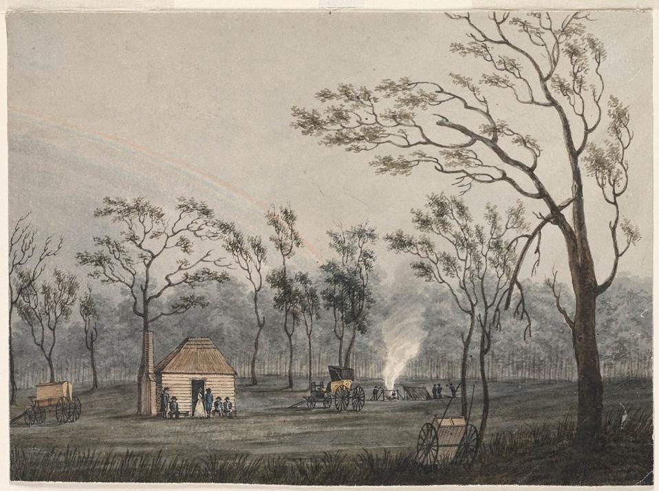
The Cowpastures provides the local context to John Macarthur's land grants and purchases, including the political constraints on settlement imposed by the colonial and British governments in their desire to protect the wild cattle. The descriptions of the countryside made by those who ventured into the Cowpastures between 1795 and 1805 to see the wild cattle provide a lens through which to view the local landscape at the very outset of European impact on the local environment. The origins, breed, conformation and description of the wild cattle of the Cowpastures are of special interest to agricultural historians.
Summary timeline - courtesy Belgenny Farm website:
1788 two bulls and five cows brought out on the First Fleet wandered off from Sydney Cove and were lost.
1795 the wild cattle were found thriving, south of the Nepean River. The area became known as the Cowpastures.
1801 the wild cattle numbered between 500 and 600 head.
1803 a hut was built at the Cowpastures, some bulls were shot and the beef salted.
1803 to protect the wild cattle, Government permission was required to enter the Cowpastures, and the cattle became Government property.
1804 there were between 3,000 and 5,000 wild cattle at the Cowpastures.
1805 John Macarthur was granted 5,000 acres of land at the Cowpastures to develop the merino wool industry. He named his grant 'Camden'.
1810 Governor Macquarie visited the Cowpastures and estimated the wild cattle to number between four and five thousand head.
1815 Gov. Macquarie began to build stockyards at the Cowpastures to tame or slaughter the wild cattle. Over the next few years he established stock centres at Cawdor, Stone Quarry (Picton) and Brownlow Hill.
1816 Local settlers and their workers were illegally catching or shooting the wild cattle.
1821 Nearly 900 wild cattle were tamed over the previous two years and incorporated into the Government's domestic herds. Many wild bulls were shot, their meat salted and hides tanned at Cawdor.
1824 The Government cattle at the Cowpastures were removed so that John Macarthur could take possession of 10,400 acres of land at Cawdor that he had acquired by grant and purchase.
1826 The Government tannery at Cawdor was closed.
1837 The Macarthurs' Camden Estate reached its maximum size of 27,698 acres at the Cowpastures.
1930s Probable descendants of the wild cattle were found in remote, rugged country near Mount Guouogang in the Kanangra-Boyd National Park which is part of the Blue Mountains, west of Camden.
References And Extras
- Trove - National Library of Australia
- Willis, Ian, Oran Park, Dictionary of Sydney, 2010, http://dictionaryofsydney.org/entry/oran_park
- St Johns Camden: 176th And 167th Anniversaries In June 2016 - Places To Visit
Sketches of Travel.
CAMDEN AND THE COWPASTURES.
THE horned cattle of Australia, in common with all other kinds of live stock, have grown into their present multitudinous herds, from a very small beginning. The " first fleet," which brought the founders of the colony, carried also from the Cape of Good Hope, two bulls and five cows, and this scanty supply was regarded as being, in its own way, the hope of the infant settlement. This living treasure was placed under the custody of a convict, who failed in his duty and allowed six of the seven under his charge to stray into the bush. To make bad worse, he concealed the mishap for several days and until it was too late to recover the cattle, notwithstanding a most protracted and painstaking search made by all and sundry. The erratic quadrupeds, as it became manifest years afterwards, were seized with the passion of free selection and had taken to the stampede interiorwards in search of "fresh fields and pastures new."
At the settlement the missing cattle were given up for lost with great reluctance; for the misfortune was of serious consequence during the time of trial which pressed so heavily upon the recent arrivals on the barren shores of Port Jackson. It was conjectured, most probably, they had been slaughtered by the blacks, who have always been more partial to beef than kangaroo flesh, and no one expected to hear again of the Cape cattle, as, in point of fact, nothing was heard of them till Governor Phillip had gone and the first chapter of our history closed.
Shortly after Captain Hunter's assumption of authority, when the aborigines were allowed more free access to the settlement, it was noticed that those who came from a distance inland were playing strange antics in their corrobborees in the way of bellowing and butting in professed imitation of some large animals which had been seen in their own hunting grounds. It was conjectured as the most probable inference that these, must be the long lost cattle or their progeny. After a short search a herd, about 60 in number, was discovered about 40 miles from Sydney. They had selected a fine tract of country, about 60,000 acres in extent, and bounded by the Bargo, Upper Nepean, and Warragumba rivers. From the circumstance of its first occupants it received and still retains the name of the "Cowpastures." The discovery of the lost cattle, now so largely increased, was reckoned a singular piece of good fortune for the still struggling colony, and the herd was strictly protected by Government order. But this seeming gain grew, in course of time,into a real nuisance, for being at best an inferior breed, they got mixed up occasionally with the cattle of the neighbouring settlers and endangered the purity of the stock. A representation to this effect having been made to Governor Brisbane, an order was issued for their destruction, which was carried into effect without delay, and thus, about the year 1824, the "Government black cattle" ceased to exist, either as a temptation to poachers or a scourge to settlers.
The district of the Cowpastures having been reserved for the purpose just indicated, it was necessarily later in being settled than were some of the surrounding parts, although of an inferior character. The prohibition which was laid on the coveted domain was relaxed, however, in favour of one colonist who, by rare energy and foresight, did more than any of his time to turn the young and pliant colony into the untried groove in which it has since kept running with constantly accelerating progress. This remark-able individual was John Macarthur, the honoured founder of the family who still occupy the Camden estate.
Mr. Macarthur came to the colony, in 1790, as lieutenant of the first detachment of the N.S.W. Corps, but left the service about three years after. Receiving a grant of 200 acres of land, he created the historic " Elisabeth Farm," near Parramatta, where he made some interesting and thoroughly successful experiments in wool growing and the breeding of sheep. Other business took; him to England in 1803, and he turned his opportunities to account by laying before the Privy'Council certain facts and theories which seemed to indicate the possibility of making New South Wales a great wool-producing colony. Macarthur's proposals were listened to with attention and his scheme was happily entertained with favour. He was permitted to purchase a few merino sheep from the royal flocks, in order to insure the best breed, and, the better to enable him to carry out his experiment, a grant was made of 10,000 acres of ground. This land was selected on a part of the Cow-pastures district, as affording the best conditions for the success of an enterprise on which so great issues depended.
Success indeed soon declared for the new venture, and the wool industry, notwithstanding many irritating impediments thrown in its path by a protective policy in Eng-land, was clearly seen to be the future stamina of Australia's prosperity. These prognostications have been amply fulfilled, for, from that day to this, the enterprise has grown with a marvellously increasing development. The great Australian squatting interest, which now looms with such proportions in the eyes of the whole world, had Mr. John Macarthur for its father and the Cowpaatures for its cradle.
The ancestral home of the Macarthur family is provided with all the comforts and conveniences of an ordinary English mansion. Its present occupants are Sir William Macarthur, now far advanced in life, and Captain Onslow, formerly member for the district. The fine garden which is attached to the house has, like the estate generally, played an important part in the, enrichment of the colony at large. The proprietors; have spared neither trouble nor expense in importing and acclimatising the newest and most approved varieties of garden plants, and especially fruit trees, of which " Sir William Macarthur's large Italian yellow peach" is only one of a host which could be men-tioned. As soon as these valuable varieties have been established in Camden garden, Mr. Ferguson has been invited to propagate them in his neighbouring nursery, from which they have been transplanted in thousands of our colonial orchards.
Camden county was the first of our agricultural districts, with the exception of the Hawkesbury basin; but the all-devouring rust having put an end even to the attempt to grow wheat, its place in the produce of cereals has sunk to zero. Its prosperity now depends on its grazing capabilities, both natural and artificial, with dairy farming pursuits. The soil is of a varied character, but generally good ; some being of a rich alluvial description, and most of the remainder excellent for pastoral purposes. The scenery is exceedingly pleasing, undulating for the most part, sometimes rising into picturesque hills and wearing every-where an aspect of tranquil loveliness. From any of the prominent points of view the landscape is seen to be dotted over with the snug and elegant seats of "country gentlemen." Most of these are historic estates, having been selected on the land-grant system by the most successful of the fathers and founders of the colony. A few of them remain as patrimonial inheritances in the occupation of representatives of the old families, but most have changed hands under the stern re-verses of fortune in the absence of a law of entail. The Camden estate, as already noticed, is still owned and occupied by the Macarthur family; but a process of disintegration has begun here, too. Quite recently, as much as 6000 acres have been sold to a Syndicate, and is now in process of sub-division for the purpose of being sold by auction. Other seats in the district. worthy of notice are- Kirkham, formerly the patrimonial domain of the descendants of Oxley, the explorer, but now in possession of the Hon. James White; Wivenhoe, the property of the late Sir Charles Cowper, and presently occupied by Mr. Thomas ; Brownlow Hill, the residence of J. Downes, Esq.; Oram Park, belonging to E. L. Moore, Esq.; Molesmain, leased by Captain Mc'Donald; and Harrington Park, the estate of William Rudd, Esq.
The township of Camden is situated in a pretty and quite picturesque position. It is about eight miles distant from Campbelltown, with which place it is now being connected by a tramway.
The Nepean River is in close proximity-so close indeed as to prove a very undesirable neighbour in times of flood, as the low flats outside the town are then in danger of being submerged. For a long period the population has remained pretty stationary and may be set down at 700 or 800. For a small place it has received an ample supply of churches. The denominations represented, with more , or less success, are-the Anglican, with a fine church " set upon a hill" and visible for miles around ; the Roman Catholic, the Presbyterian, the Wesleyan, and the Primitive Methodist. This is a very liberal allowance, and certainly justifies a local worthy in saying that Camden ought to be a very holy place if all the clergymen did their duty.
Another public building of some architectural pretensions is the Commercial Bank, only recently erected. Among private residences the houses of Dr. Goode and Dr. Jackson maybe singled out as being of a superior class. Manufactures of any importance do not yet exist, however it may be when tramway facilities are opened up. Should the traveller be inclined to see something worthy the name of a local industry, he would do well to take a short walk outside the town and visit the long established nursery of Mr. Francis Ferguson, on the banks of the Nepean. The proprietor is an enthusiast in arboriculture, and has laid the colony under an obligation while gaining honour to him-self, by raising from seed the superb Jacaranda, which is now becoming so great a favourite in our gardens, and pleasure grounds. This nursery has also obtained a high position from the acknowledged superiority of its fruit trees, some of which, like the " Camden Excellent" peach, are known by their local names all over the colony. Sketches of Travel. (1881, November 26). Australian Town and Country Journal (Sydney, NSW : 1870 - 1907), p. 26. Retrieved from http://nla.gov.au/nla.news-article70962591
FIRST FLEET CATTLE.
Disaster and its Sequel.
(BY "BORRENUICK.")
The loss early in June, 1788, of the black Cape cattle (four cows and two bulls) landed from the First Fleet late in January, 1788, appeared to the young and ill-fed community at Sydney Cove as an "absolute disaster." But the discovery in 1795 of several herds (totalling over 100 head) across the Nepean River, turned the disaster into perhaps the most splendid and important event of the early years of white settlement in New South Wales, giving an in-sight and comprehension of the capabilities of this new country to maintain vast herds of excellent cattle.
The full significance and tremendous influence of this event quickly appealed to that astute and grand pioneer, Captain John Macarthur (father of the Golden Fleece in Australia). He at once saw the possibilities of the "Cowpastures" country for meeting the requirements of his fine wool sheep, which did not thrive to his satisfaction near Rosehill, and he early lodged an application for a part of that country. But this was opposed by the Governor and his successors, who desired to reserve the area for the exclusive use of the wild cattle, as they had thrived so well there.
Captain John Macarthur in connection with his painstaking efforts to improve his fine wool flock visited England in 1801, and succeeded in attracting the attention of those in high places to the potentialities of the New South Wales for increasing the quantity and quality of the fleece to a perfection hardly known else-where in the world. Undoubtedly his was the vision splendid. His contentions were subsequently endorsed by Captain John Hunter (on his return to England in 1804). This, together with the "cloth-weaving experts'" opinion that the sample exhibited was equal to the best "Saxon" or "Spanish" wools, eventually succeeded in gaining the kindly interest of his Majesty King George, also of the Secretary of State, Lord Camden— causing the Privy Council to grant to John Macarthur an area at the "Cowpastures" as an encouragement for him to persevere in his efforts at high-class wool-growing. John Macarthur named his grant "Camden Park", in honour of his patron, Lord Camden.
HOW THE FIRST CATTLE WERE LOST
The cattle landed in January, 1788, were depastured over what is now known as the "Domain," being yarded each night near the "farm" (Botanic Gardens), and to prevent them straying a convict named Edward Cor-bett was made herdsman and given the strict-est instructions not to let them out of his sight. All went well until early in June, 1788, on returning after dinner, the cattle were missing.
Numerous parties were sent out to try and recover the cattle, but after three weeks' fruit-less search. Governor Phillip abandoned the matter, concluding the cattle had been spear-ed by the blacks, or strayed far into the Interior in quest of better feed.
There is little doubt that the cattle gradually made their way up George's River to some point between Campbelltown and Appin, their instinct then impelling them to cross the watershed at the Nepean River in the vicinity of Menangle. This must have been subsequent to August, 1790, as Captain Walkin Tench's was the first white party to cross the Nepean River a little upstream from the town of Camden on August 3, 1790, and they did not see any signs of the presence of cattle. The exploring party also failed to observe any good quality land, notwithstanding that they penetrated almost to the Razorback, which Captain Tench named "Pyramid Hill" on account of its conical appearance.
During October, 1795, two convicts while on a hunting expedition gathered from rumours among the blacks that cattle existed across the Nepean River. After penetrating to the river they on their return to Rosehill reported having seen a herd. Governor John Hunter was particularly busy at the time, but sent a reliable person to investigate the matter. He verified the hunters' statement, and, as a consequence, the Governor and party set out from Prospect Hill on November 8, 1795, and after travelling for two days in a southerly direction, with Pyramid Hill as their objective, crossed the Nepean (Tench's Wolgan) and to their surprise and satisfaction fell in with a very fine herd of over 40 grazing in "country remarkably pleasant to the eye, and the finest yet discovered in New South Wales, the soil good and eligible for cultivation, everywhere thick luxuriant grass " This marked contrast to the country's appearance to Captain Tench in 1790 is accounted for by the long dry period ending in 1792, being succeeded by a bounteous rainfall changing the whole outlook infinitely for the better. The party camped for the night, hoping to see the whole herd next day, and definitely ascertain if they were the progeny of the strayed Cape cattle. With this object the Governor directed the killing of a calf but next morning while lying in wait for the whole herd (60 head) to pass were furiously attacked by the monarch of the herd, which resented their unwelcome intrusion, the party in self-defence were compelled to kill the beast, which had all the characteristics of the Cape cattle.
The Governor paid a second visit to the "Cowpastures" in June, 1796, and ascended the highest point in the neighbourhood (now Mount Hunter), reporting the view from the summit as full of grand objects, wood, water, plains, and mountains everywhere on that side of the Nepean River the soil was excel-lent, and eligible for cultivation. He again visited the wild cattle in September, 1799 along a new route westerly of Cobbitty through good country, and on arrival near Mount Taurus fell in with a fierce herd of about twenty. Their dogs eventually drove off the herd, but in doing so detained a bull calf about six weeks old. The Governor directed its liberation, but, strange to say, the calf would not quit the party, but persisted in running between the legs of the horses and bellowing for the herd. Apprehending great danger to the party if the herd returned. Its cries were ended by shooting it through the head—the whole party regaling itself on veal, a rare dish in the colony.
GRADUAL DISAPPEARANCE
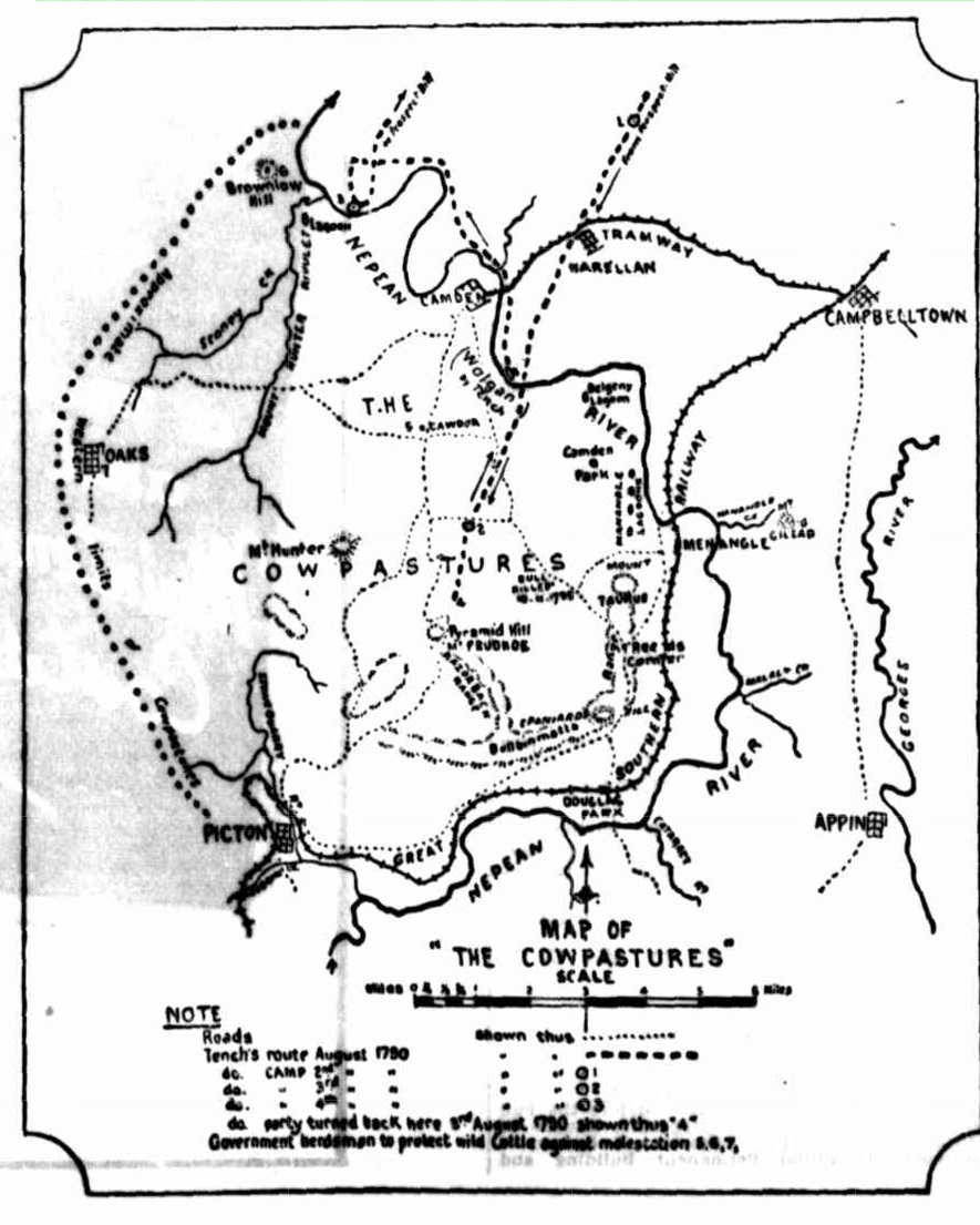
Many proposals were made to drive the cattle into the settlement, but the Governor determined to allow them to remain undis-turbed, and to guard against any attempt at their destruction he issued a proclamation against anyone crossing the Nepean River without his permission. He also established herdsmen's stations at Cawdor, Brownlow Hill, and the Oaks (see map) in his efforts towards their preservation. But these laudable efforts were eventually frustrated by the settlers raiding the wild herds from time to time to recover their own cattle, whenever they be-came mixed with the wild stock. In the course of time (say, about 1812) the wild herds had completely disappeared, and the name "Cowpastures" gradually dropped into disuse, while the name "Camden" became general for that locality.
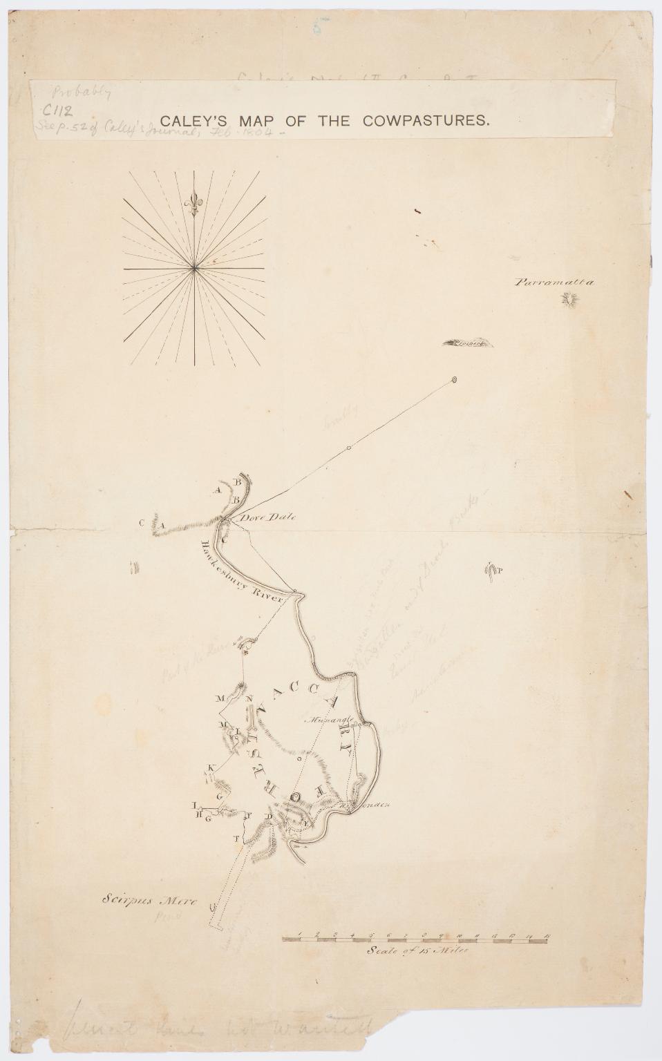
In the accompanying map I have endeavoured to revive several of the interesting names early applied to certain natural fea-tures but not now shown on official maps viz—"Pyramid Hill", "Mount Taurus," "Menangle" (the blacks' name for the four lagoons near Mount Taurus), "Bulbinmatta," for the range of hills running southerly from Mount Taurus, this name is a good example of a combination of English and aboriginal words-"Bull," "been," "matta," native meaning "sit down." Hence the whole name "Bulbinmatta" is literally equal to "Cattle Camp," the wild herds resorting to the hill-tops to camp and escape from the cold damp air of the valleys at night.
FIRST FLEET CATTLE. (1932, August 13). The Sydney Morning Herald (NSW : 1842 - 1954), p. 9. Retrieved from http://nla.gov.au/nla.news-article16889435
WHERE THE WILD HERDS WERE FOUND IN 1795.
WHERE THE WILD HERDS WERE FOUND IN 1795. (1932, August 13). The Sydney Morning Herald (NSW : 1842 - 1954), p. 9. Retrieved from http://nla.gov.au/nla.news-article16889509
Oran Park
by Ian Willis 2010
CC BY-SA 2.0
Oran Park is a locality on the southwest rural-urban interface of the Sydney metropolitan area. It is an area that has been a zone of transition and contrasts, similar to other parts of the Sydney basin.
The western part of the locality of Oran Park is delineated by the Northern Road, the southern boundary is Cobbitty Road, while in the east the area is bounded by the watercourse of South Creek and in the north Lowes Creek. The area has always had a rural character and in 2001 the population of the Oran Park–Catherine Field area was 1,470, yet within 20 years Oran Park is predicted to grow to 25,000, while the Camden local government area will surge by 390 per cent to a population of over 250,000.
The area has never had closer settlement, and the nearest urban centres have been the hamlet of Catherine Field to the north, the village of Cobbitty to the west and the township of Narellan to the south, along with the new suburbs of the Harrington Park development. The locality was part of Nepean Shire Council until 1948, at which time the shire council was split up between Penrith, Liverpool and Camden Councils. Oran Park was part of the shire's C Riding and was amalgamated with Camden Municipal Council.
Originally Oran Park was part of the traditional land of the Dharawal people, who were dispossessed, and then displaced by Europeans who established their grand colonial estates. Until recently the area largely retained a rural character with open pastures and rolling hills, creating a picturesque landscape reminiscent of rural England. The rural character has never been seriously challenged, although there have been a golf course, a trotting track, and a motor racing circuit, while some had dreams of theme parks. The first developer subdivisions in the 1960s were for small-scale hobby farming, which saw the appearance of stables, small-scale floriculture and horticulture. These urban fringe-dwellers have been recently joined by developer corporations selling dreams to new suburbanites who live in streets named after motor racing celebrities.
Early estates
The European domination of Oran Park commenced with the two principal land grants, one of 2,000 acres (809 hectares), Harrington Park, granted to William Douglas Campbell in 1815, and another to George Molle in 1815, Netherbyres, of 1,600 acres (647.5 hectares) which ran between South Creek and the Northern Road. Campbell was a member of the British merchant navy, who first visited New South Wales in 1797, and eventually returned in 1801 as master of the brig, Harrington. He had trading interests in the Pacific and was a knowledgeable navigator of the Pacific region. He settled on his property in 1817 and named it after his ship. He died in 1827.
In 1829 the Oran Park portion of Campbell's grant (800-acres) was sub-divided from the Harrrington Park estate and assigned to John Douglas Campbell, William's nephew. He leased the 800-acre (323.7-hectare) property Oran to Sydney gentleman Henry Keck in 1839 for eight years, with an option to purchase the property for £1,600. The terms of the lease confirm that JD Campbell had commenced building a house at Oran Park before 1839. Historian Rosemary Broomham maintains that 'the price of the property indicates that the house was a substantial building'. [1]
Oran Park, and other colonial estates like it, were part of the spatial pattern and economic structure of the Cumberland Plain established by a powerful colonial elite by 1840. They built themselves impressive homes, and in the Cowpastures their ilk included John Macarthur's Camden Park, George Macleay's Brownlow Hill, John Oxley's Kirkham and Elderslie, Alexander Riley's Raby, Edward Lord's Orielton, William Howe's Glenlee, Thomas Hassall's Denbigh and Garnham Blaxcell's Curtis Park. This set, who modelled themselves on the British elite, established a social and economic hegemony over the region that persisted into the twentieth century.
Unfortunately for Keck, the depression of the 1840s resulted in his lease on Oran being transferred to Henry William Johnson. Johnson completed the purchase of the property for £1,600 by raising a mortgage with JD Campbell and later Thomas Barker. Broomham maintains that the 'high price he paid for the property disproves the apocryphal tale that he built the entire house in 1857'. Johnson lived at Oran Park until 1869 when he defaulted and Barker foreclosed on him. Barker (of Maryland and Orielton) was one of the wealthiest men in the colony and a man of influence. He was a member of the New South Wales Legislative Council 1853–56 and the Legislative Assembly 1856–57.
Oran Park house was a typical country manor house with panoramic vistas over the landscape and to the important access point of the estate, reminiscent of the English park. It was set on a knoll creating 'an imposing composition set amongst landscaped grounds' and an example of the Summit Model of homestead, sited on a hilltop with the homestead complex. The house was a Georgian form with a symmetrical front, 12-paned windows and six-panelled doors, marble chimney pieces, plastered internal walls and plaster ceilings. It had two storeys, built of English bond brick. It had a lead-lined flat roof behind parapets, a two-storey timber verandah on three sides and an attached three-storey octagonal tower at the rear. The interior had detailed cedar joinery and paneling, particularly in the main entrance hall, and a geometric staircase with a large arched stair window. There was a two-storey servants' wing at the rear. The outbuildings included a cottage, silo and stable. The front of the house had a carriage loop with plantings forming a circle in front of the house, with a driveway to its entrance from the intersection of Cobbitty Road and Cowpastures Road.
Barker sold Oran Park to Campbelltown grazier Edward Lomas Moore (of Badgally) in 1871, the son of an assigned convict. Moore also owned the neighboring property Netherbyres and leased part of the combined property to farmer Thomas Cadell in 1882. EL Moore lived at Oran Park during the 1870s and 1880s and died in 1887 (at his new house at Badgally). After his death there were questions about the estate and Oran Park eventually passed to John and Frederick Moore in 1904. Frederick Moore was mayor of Campbelltown from 1901 to 1909.
Twentieth-century changes
In 1907 Oran Park was sold to Essington Moore, who in 1919 leased it and the neighboring Netherbyres, to Charles, James and Andrew McIntosh for seven years. In 1939, after Moore's death, Hubert Harry Robbins, described as a Sydney gentleman, purchased Oran Park and the neighboring properties of Netherbyres and Graham's Farm. Historian Helen Proudfoot maintains that Robbins and ER Smith ran Oran Park as a golf club along with racing and trotting courses. The house was apparently extended in the 1930s, the roof reconstructed, the side verandahs built in and a west wing and front portico added. Robbins died towards the end of the war and in 1946 his wife Joyce, consolidated the three properties into a single title of 2200 acres (890 hectares). She then promptly subdivided the property and sold off a 507-acre (205-hectare) allotment.
During World War II, when HH Robins owned the Oran Park property, 260 acres (105 hectares) were used by the military for the Narellan Military Camp. The camp was located on the intersection of Cobbitty Road and the Northern Road (Green's Corner), and occupied all four points of the intersection. The camp and its facilities, which also occupied parts of Denbigh and Harrington Park properties, functioned as a military base from 1940 to 1944, with all buildings disposed of by 1946. The camp was used for troop training, where raw recruits were formed into units, then mobilised for active service in the Pacific conflict. The camp, which was planned to accommodate over 3,500 troops, was a tented camp with huts for administration, storage, messing and recreational purposes. During the occupation part of the Oran Park property was used as a grenade firing range. It was one of three practice ranges adjacent to the camp.
The 507-acre property changed hands and was sold in 1961 to Edward Alfred Star, a Rose Bay hotel proprietor, and his wife Emily. They subdivided the Hume Highway and Cobbitty Road frontages into 26 hobby farms lots of five acres (two hectares) each. The remaining property was further subdivided into three hobby farms, one of which contained Oran Park homestead and 229 acres (92.6 hectares). Star retained one lot and sold the others, which included the homestead, to Newport investors John and Peggy Cole in 1968.
The Coles sold Oran Park homestead and stables in 1969 to the Honourable Lionel John Charles Seymour Dawson-Damer, a member of the English aristocracy. The Dawson-Damers undertook restoration guided by architect Richard Mann. John 'DD' Dawson-Damer was an Old Etonian and car collector. He was a prominent motor racing identity and was killed in an accident while driving his Lotus 63 at a race meeting at Goodwood, West Sussex in 2000. Dawson-Damer was the managing director of Austral Engineering Supplies Pty Ltd, and was involved with the International Automobile Federation and the Historic Sports Racing Car Association of New South Wales. Ashley Dawson-Damer, his socialite wife, was a member of the council of governors of the Opera Australia Capital Fund and a board member of the National Gallery of Australia Foundation. After her husband's death she sold the house in 2006, with its historic gardens and 107 hectares of pasture, for $19 million to Valad Property Group.
In mid-2009 Mark Frinsdorf of the Valad Property Group stated that in the future Oran Park house and the surrounding gardens will become part of a 'high quality integrated heritage residential development as part of the residential growth release area in South West Sydney'. In late 2009 Valad put the property up for sale and then withdrew it six months later.
Oran Park house has been under consideration for listing on the New South Wales State Heritage Register since 2004. The lack of movement on this important heritage item reflects the tenuous nature of heritage protection for some New South Wales colonial properties.
Motor racing
The south-western and western part of the original estate adjacent to the intersection of Cobbitty Road and the Northern Road was the location of the Oran Park Motor Racing Circuit. The main grand prix circuit was 2.6 kilometres long with a mixture of slow, technical and fast sweeping corners as well as changes in elevation around the track. The main circuit was broken into two parts. The south circuit was the original track built in 1962 by the Singer Car Club. It consisted of the main straight, pit lane garages and a constant radius 180-degree turn at the end. The track hosted its first Australian Touring Car Championship in 1971, which was a battle between racing legends Bob Jane and Allan Moffat, and drew a crowd of over 30,000. The north circuit was added in 1973 and was an 800-metre figure of eight.
In 1976 there was a proposal to create a sports and recreation centre on the raceway. The development was raised again in 1981 and was to include a themed entertainment park, an equestrian centre, dude ranch, motel, health and fitness centre, model farm and cycling, hiking and bridle trails. But it all came to nothing. In 1983 Bill Cleary stated to the Macarthur Advertiser that his family had owned the property for 38 years. It was subsequently sold in the mid-1980s to Leppington Pastoral Company, owned by the Perich family. Leppington Pastoral Company is arguably one of the largest and most advanced dairy farms in Australia with a herd of 2,000 cows. The Perich family also has interests in Narellan Town Centre, the Oran Park Town centre land release and fertilisers.
Over the years the raceway has been the base for a number of subsidiary activities that included a two dirt circuits, two four-wheel training venues, a skid pan and a go-kart circuit. The racing circuit has been used for a variety of motorsport including club motorkhanas, touring cars, sports sedans, production cars, open-wheelers, motocross and truck racing. The track hosted the Australian Grand Prix in 1974 and 1977. In 2008 a number of organisations used the circuit for driver training, including advanced driving, defensive driving, high performance and off-road driving. The December 2008 V8 Supercar event was the 38th time a championship was held at the track.
The racing circuit was rezoned for housing in 2004, and Tony Perich was launched into the BRW Top 200 rich list and named the 42nd richest person in Australia. The New South Wales Planning Minister, Craig Knowles, announced a partnership between Greenfields Development Corporation, a Perich family company, and Landcom for the development of the Oran Park raceway for housing.
Sadly for motoring enthusiasts the circuit was eventually closed in January 2010. The track has been silenced, like other Sydney suburban raceways, which have included Amaroo Park, Warwick Farm, Mt Druitt, Sydney Showground, Liverpool and Westmead speedways.
Many racing legends have driven on the track over the years. The list has included Sir Jack Brabham, Sir Stirling Moss, Kevin Bartlett, Fred Gibson, Ian Luff, Bathurst legends Alan Moffat and Peter Brock, and Formula One driver Mark Weber. Many innovations were implemented at the track and included night racing, truck racing and NASCAR racing.
The track was always a crowd favourite. Fans were close to the action and could see the entire circuit. According to David Fitzsimons the crowd had a 'fantastic vantage point on the hills and from the grandstands'. Motoring enthusiasts might miss the spectacle, but they will not miss the basic amenities and the long queues of traffic in and out the circuit.
Oran Park is a place of lost memories and grieving. Motoring enthusiasts have been displaced and dispossessed by a new band of arrivals who have different hopes and aspirations.
Suburban development
Oran Park and the associated Turner Road precincts (now Gregory Hills) were the first two areas that were developed as part of the state government's South West Growth Centre plan. The government's Growth Centres Commission stated that the South-West Growth Centre stretches from the edge of Currans Hill and Harrington Park in the south to Kemps Creek in the north. The centre is divided in 18 precincts and is eventually planned to accommodate 295,000 people by 2031. The Oran Park and Turner Road Development is expected to house 33,000 people.
In 2007 Tony Perich told the Sydney Morning Herald that his development company, Greensfields Development Corporation, planned to build almost one-fifth of the 11,500 dwellings in Oran Park and Turner Road in a joint venture with Landcom. The Planning Minister, Frank Sartor, stated that the state government would create 'liveable communities'. In 2008 the new Planning Minister, Kristina Keneally, declared that Oran Park was 'the biggest residential development we have seen in Sydney for the past 10 years'. The project would incorporate cycling and pedestrian paths, a supermarket, retail complex, medical and civic centre, library, police station and other government agencies. The minister said that
phase one would have two school sites, a display home village, road infrastructure, playing fields, cycle paths, a seniors' living precinct and the first commercial building of the town centre.
Not everyone was so sure about these developments and in 2007 the Macarthur Chronicle greeted the news with a headline, 'Home invasion'. 'The rural landscape surrounding Camden will be engulfed by suburbia'. Even at this early stage journalist Catharine Munro predicted that the urban development would be 'as dense as some of Sydney's most congested areas'. In 2008 Chris Patterson, Camden's mayor, stated that 'locals were bracing themselves for an onslaught of new residents.'
Rob Elliott, the president of Macarthur Regional Organisation of Councils, was concerned about the provision of adequate infrastructure and predicted that new residents would be 'busy sitting on Narellan Road stuck in traffic'. His words were prophetic, as morning commuters will currently attest. The poor provision of public transport has meant that the Camden local government area has one of the highest car ownership rates in the Sydney area, a trend likely to continue into the foreseeable future.
The first Oran Park home sites were released for sale in late March 2010. Buyers camped out for days in the hope of purchasing their part of the Australian dream. A shortage of new-home sites in the Sydney basin has resulted in a pent-up demand for housing. According to the buyers, the attractions of Oran Park are the community concept and the affordability of the development.
A thematic approach has been taken throughout the master-planned estate and the developers have paid homage to the raceway, rural themes and token gestures to the area's history. Robert Sullivan, spokesman for Landcom, stated that
future residents will be able to see an artist's version of a chequered flag where the old finish line used to be; buy a house along the main straight; live in streets named after Brock, Moffat and the ilk; relax in Wayne Gardner Reserve; and let their children play on the pedal cars on the miniature racetrack opposite the sales centre.
A statue of a cow is located outside the sales centre, and a herd of cows provided a backdrop to the carpark on the open day, while the Perich family continue their dairy business on the farm adjacent to the development site.
In reality the new fringe dwellers are just part of the extension of Sydney's urban sprawl, although Landcom's Robert Sullivan vehemently denies this. He maintains that, 'we're putting a new town on the map of Sydney' and draws a comparison with developments at Rouse Hill.
A new suburb
An associated part of the Oran Park precinct is the new suburb called Gregory Hills. It is part of the Turner Road release and was established in 2008 east of Camden Valley Way. Gregory Hills is located in the upper reaches of South Creek and constitutes the conjunction of the boundaries of Oran Park, Catherine Fields, Currans Hill and Smeaton Grange. The development is made up of 415 hectares of Marist Brothers-owned land that was part of St Gregory's college. The name Gregory Hills is derived from the original St Gregory's Chapel on the Marist Brothers land and the topography of the area.
There was controversy over the naming of the locality after the developer, Dart West Developments, wanted to call it Camden Hills. There was local opposition and other suggested names included St Gregory's Hills, Gledswood Hills, Chisholm Hills and Scenic Hills. In 2007 planning consultants Development Planning Strategies stated that the site should have a 'sense of identity and one which is easily recognisable to the area'. The consultants maintained that the name Gregory Hills would provide residents with a 'sense of community ownership and awareness of the historical land uses and foster a sense of place'. The name Gregory Hills was registered with the Geographical Names Board in 2008.
Building community in these greenfield developments is a challenge and developers' promotional material is rich in its rhetoric. Community building is about participation and the creation of social capital. New arrivals might live on the rural fringe yet their heads are firmly located in the metropole. New suburbanites are part of the Otherness. They are outsiders trying to get on the inside. It is a challenge most will aspire to, few will succeed.
The commodification of the rural setting and local history area constant themes for land releases in the Camden local government area. The Dart West website claimed in 2009 that their development is 'located in the historic and beautiful Camden district, combining the best of Camden country living'. New residents' houses, the developer maintained, will be 'set in rolling paddocks and bushland ridges and valleys in a beautiful rural environment'. These values are at the heart of the existing community's sense of place and identity, and attract the new suburbanites. The new arrivals come looking for a place where 'the country looks like the country'. Yet the paradox of the whole situation is that in time they will convert the area into something that they are trying to escape, Sydney's urban sprawl.
References
Rosemary Broomham, 'Oran Park, Oran Park Precinct, Narellan, NSW, History', in Tropman and Tropman, Oran Park, Curtilage Study and Capability Strategy, Landcom, Sydney, 2006
About the Oran Park Town Project
At Oran Park Town, UrbanGrowth NSW is a development partner with Greenfields Development Company. UrbanGrowth NSW will fund all development works and be responsible for the development of the first 2,700 lots in Oran Park, including the final delivery of the developed lots to the general public and/or the building industry.
Some of the lead-in works (called enabling works) have been funded by Greenfields Development Company via external borrowings. UrbanGrowth NSW manages the enabling works.
UrbanGrowth NSW’s role includes utilising the land efficiently and producing a community of unique identity. UrbanGrowth NSW also has the potential to play a role in the coordination of infrastructure for all of Greenfields Development Company’s lands (12,500 dwellings) and influence the development of the future town centre. from https://www.landcom.com.au/places/oran-park-town
About Landcom
MAY 31, 2019
Landcom is the NSW Government’s land and property development organisation. We are a State Owned Corporation working with government and the private and not-for-profit sectors to deliver exemplary housing projects that provide social and economic benefits to the people of NSW.
Landcom helps the NSW Government achieve its urban management objectives by taking a lead role in improving the supply, diversity and affordability of new housing.
Our mission is to create more affordable and sustainable communities.
Tony Perich
Tony’s parents, Kolombo and Julia Perich, immigrated to Australia from Croatia and started making their living as market gardeners. Tony left school at an early age to work with his family. Keen to expand the business he and his brother persuaded their father to move into the dairy industry.
In 1963 the family purchased 242 ha of land at Bringelly and built a dairy, milking 200 cows. Together with his wife Catherine and his family, Tony established the Leppington Pastoral Company and set about building a state of the art dairy, currently milking 3,000 cows per day.
Over the years the Leppington Pastoral Company has diversified into other areas including Freedom Foods, Organic Fertilisers, Oran Park Raceway, Narellan Town Centre and Greenfields Development Company.
Oran Park Raceway, an extremely well patronised sporting venue, will close in 2008 to make way for Oran Park Town Centre. A ten year project, developed by the Perich Family’s Greenfields Development Company in conjunction with Landcom, Oran Park Town Centre will provide housing as well as retail, schools and community facilities.
Tony is a strong supporter of local charities, for example he was a principal fundraiser for the Respite Care Facility for the Spastic Centre in Liverpool. He is also a strong supporter of the local business community. He is a member of The Narellan Rotary Club and The Narellan Chamber of Commerce as well as a former member of The Greater Western Sydney Economic Board. Tony is still interested in the Dairy Industry and is a member of the Dairy Research Foundation of the University of Sydney.
From simple beginnings on the dairy farm at Bringelly, Tony and his family have played a key role in the development of the Macarthur Region.
PORT HACKING.
TO THE EDITOR OF THE HERALD.
Sir,-In your issue of this morning, under the heading of "The National Park," I observe the following remarks :- " My companion relates to me an interesting little fact with which this paper may be fittingly closed. It was Commander Aitken who first explored the port, and discovered the river which flows into it ; and in commemoration of his discovery his name was bestowed on both port and river. But some untoward fate brought it about that the name 'Aitken' was corrupted into ' Hacking,' and when fresh charts were made the popular nomenclature was adopted, and so the mistake was perpetuated for all time."
Permit me to state that Port Hacking was named after Henry Hacking, seaman, formerly quartermaster in H.M.S. Sirius. Henry Hacking was despatched, during the earliest years of the colony, to make various coast surveys. On one of these expeditions he discovered and surveyed the port now bearing his name, and the word Hacking is therefore correct.
This is the same Hacking who, in 1794, attempted the passage of the Blue Mountains (being two years before Bass attempted it), and penetrated 20 miles further than any previous European. I am, &c,
JOHN W. DEERING. Riverview, Five Dock, 9th December.
PORT HACKING. (1881, December 10). The Sydney Morning Herald (NSW : 1842 - 1954), p. 7. Retrieved from http://nla.gov.au/nla.news-article13500928
PORT HACKING.
TO THE EDITOR OF THE HERALD.
Sir,—I am sorry again to trouble you, but the letter of Mr. Woodhouse in this morning's Herald necessitates a reply from me. It is not a matter of very great importance as to whom the port was named after ; but it is a matter of interest to those who desire to preserve the original nomenclature of this continent. It would have been more satisfactory if Mr Woodhouse had given dates as to the time Mr Midshipman, afterwards Commander, Aitken was in Sydney.
My former note to you on this subject was written from memory. Since then I have referred to "Collins' New South Wales" and also to Flinders'. The latter says, at page 102 of his introduction, that in sailing up the east coast with Bass, in the Tom Thumb in 1876, " We found the river, or rather port, which was the original place of our destination, and it having been a pilot named Hacking from whom the first information of it had been received, it was named after him " We may well suppose that Flinders, being in commission for the special duty of maritime exploration and survey in these waters, knew thoroughly what he was writing about.
On the chart by William Dawes, in " Hunter's New South Wales," in 1792, Port Hacking is not shown, and nothing further south than Botany Bay the chart embracing "all those parts of the territory of New South Wales which have been seen by any person belonging to the settlement."
On the chart published in " Collins's New South Wales," dated 1st May, 1802, the port we are considering is first shown, and the name is " Port Hacking."
If Mr, Woodhouse is right, then it is clear that Flinders and Collins (who lived and wrote at the time) must be wrong ; but if they are right, which no reasonable person can doubt, then Mr Woodhouse is in error. Will Mr. Woodhouse give the date of Mr. Aitken's first arrival in this country.
Henry Hacking was quartermaster on board H.M.S. Sirius, which, with the tender Supply, were the first two vessels that entered the waters of Port Jackson.
When the settlement was formed, Hacking appears to have been employed in maritime surveying, and was, I think, the first harbour master and pilot. He is spoken of as a person of trust, and a man "who could be depended upon." During some of his coast expeditions he must have discovered the port now bearing his name, as recorded by Flinders in 1796, eight years only after the arrival of the Sirius.
Unlike Mr. Woodhouse, I have no personal interest in the matter ; and having no family traditions as to the name to fall back upon, am compelled to resort to the facts as nar- rated by that eminent and singularly accurate man, Flinders. 'Palmam qui meruit ferat.'
I am, &c.,
JOHN W. DEERING.
December 21.
PORT HACKING. (1881, December 23). The Sydney Morning Herald (NSW : 1842 - 1954), p. 7. Retrieved from http://nla.gov.au/nla.news-article13501825
NB - both Mr. Woodhouse and Mr. Deering were both right: Port Hacking was named by Matthew Flinders in 1796 after Port Jackson pilot Henry Hacking. Hacking had told Flinders of a large river south of Botany Bay which First Fleet midshipman of HMS Supply, James Aicken, had discovered. Originally named Port Aicken (alternatively Akin or Aken) after James Aicken.
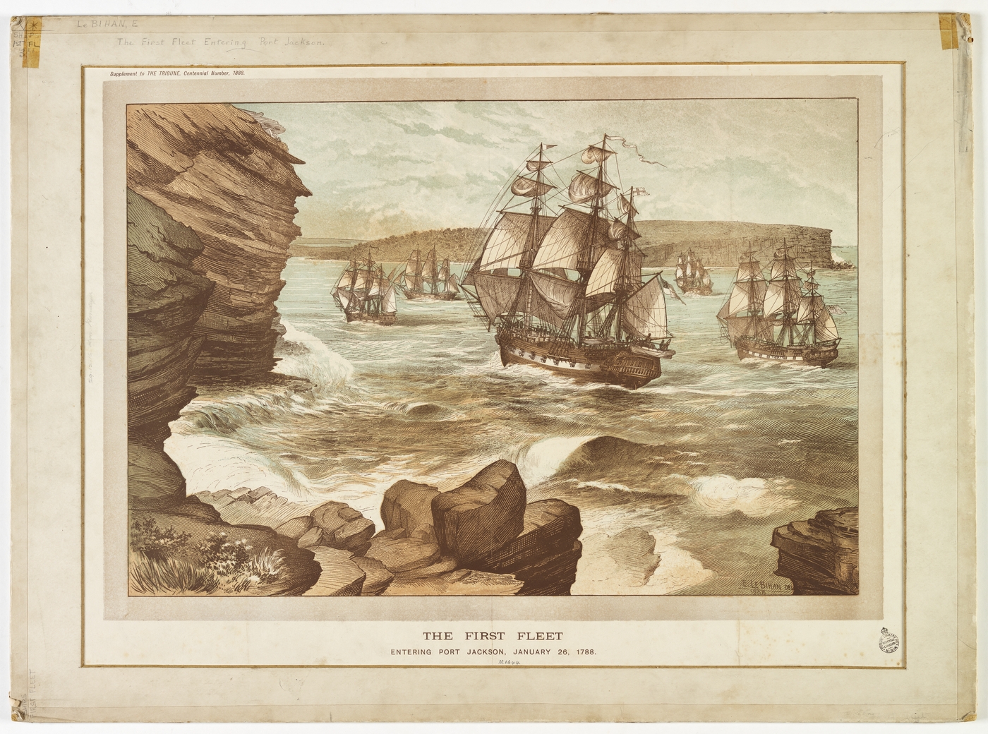
The First Fleet entering Port Jackson, January 26, 1788, drawn 1888 / E. Le Bihan. Image No.: a9333001h, courtesy Mitchell Library, State Library of New South Wales
Hacking was quartermaster of Sirius, the flagship of the First Fleet that established the first European colony in New South Wales, Australia in 1788. He probably returned to England after the loss of the Sirius in 1790, as he returned to Sydney in the Royal Admiral in 1792.
Henry Hacking was the principal game hunter in the colony and who first told them of a large river he had seen inland on kangaroo hunting expeditions. Hacking was the quartermaster on HMS Sirius, part of the First Fleet under the command of Governor Arthur Phillip.
Mr. Hacking became a skilled, adventurous bushman, who led many hunting expeditions to supplement meat rations for Australia’s first settlers. He was amongst the party that found the lost government cattle at Cowpastures in 1795.
He was also the man who in 1802 killed Pemulwuy an Aboriginal resistance fighter and a Bediagal man who had killed and harassed settlers and who since 1790 had been a wanted man.
In 1800 and 1801 he piloted the Porpoise into and out of Port Jackson. In 1802 he was appointed first mate of the Lady Nelson.
In 1803 he was found guilty of stealing naval stores from Investigator and sentenced to death, then reprieved on condition that he was transported to Van Diemen's Land.
In 1804 Hacking was appointed coxswain to the lieutenant-governor at Hobart. In July 1806 he was appointed pilot at Hobart at £50 a year. In 1816, 'useless as a Pilot from Drunkenness and other infirmities', he was granted a pension of half his salary. He died at Hobart on 21 July 1831, aged 81.
European impacts have been substantial on Port Hacking: the river has been effectively dammed at Audley, the dynamics of the frontal part of the marine delta were substantially altered by the creation of a fish hatchery at The Basin, shell grit extraction decimated large seagrass beds, and the entire northern shore is urbanised. Port Hacking has been closed to commercial fishing for about a century, and there are other catch/harvesting closures throughout the Port. The northern headland, located at Cronulla is called Bass and Flinders Point.